- Melville Island (Northwest Territories and Nunavut)
-
Melville Island 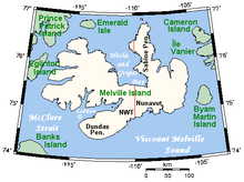
Closeup of Melville Island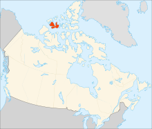
Geography Location Northern Canada Coordinates 75°30′N 111°30′W / 75.5°N 111.5°WCoordinates: 75°30′N 111°30′W / 75.5°N 111.5°W Archipelago Queen Elizabeth Islands
Canadian Arctic ArchipelagoArea 42,149 km2 (16,273.8 sq mi) Area rank 33rd Country CanadaTerritory  Northwest Territories
 Nunavut
Demographics Population Uninhabited 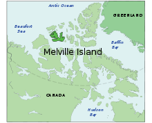 Melville Island, Canada
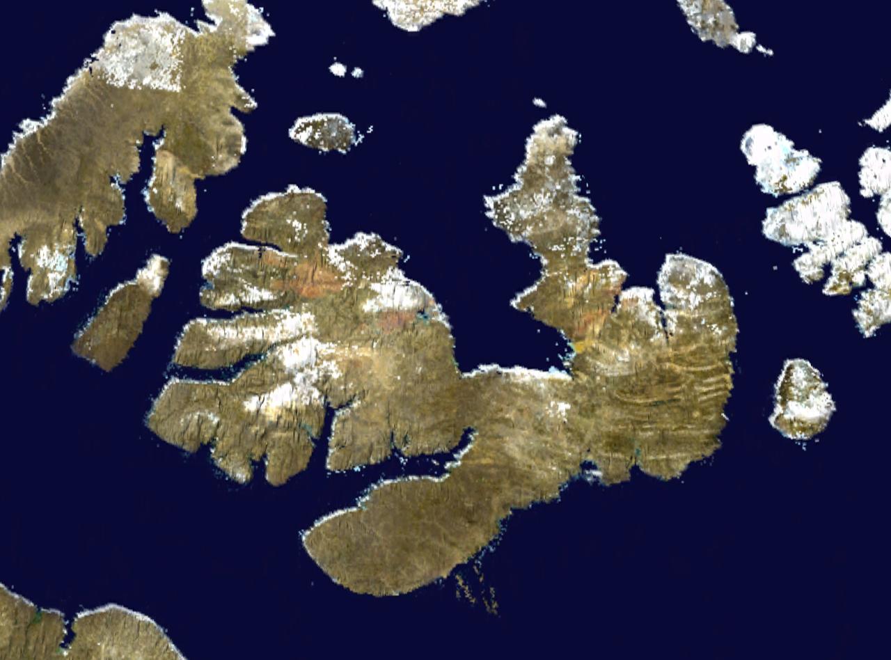
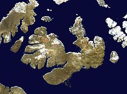 Satellite photo montage of Melville Island
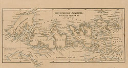 Melville Island, Canada
Melville Island is a vast, uninhabited member of the Canadian Arctic Archipelago with an area of 42,149 km2 (16,274 sq mi). It is the 33rd largest island in the world and Canada's eighth largest island. Melville Island is shared by the Northwest Territories, which is responsible for the western half of the island, and Nunavut, which is responsible for the eastern half. The border runs along the 110th meridian west. The mountains on Melville Island, some of the largest in the western Canadian Arctic, reach heights of one kilometre.
The island has little or no vegetation. Where continuous vegetation occurs, it usually consists of hummocks of mosses, lichens, grasses, and sedges. The only woody species, the dwarf willow, grows as a dense twisted mat crawling along the ground. However, a diverse animal population exists: Polar bear, Peary Caribou, muskox, Northern Collared Lemming, Arctic Wolf, Arctic Fox, Arctic Hare, and Ermine (Stoat) are common. A 2003 sighting of a Grizzly bear and grizzly tracks by an expedition from the University of Alberta represents the most northerly report of grizzly bears ever recorded.
Melville Island is one of two major breeding grounds for a small sea goose, the Western High Arctic Brant (or Gray Brant, Intermediate Brant or Grey-bellied Brent Goose). DNA analysis and field observations suggest that these birds may be distinct from other brant stocks. Numbering only 4-8,000 birds, this could be one of the rarest goose stocks in the world.
Contents
History
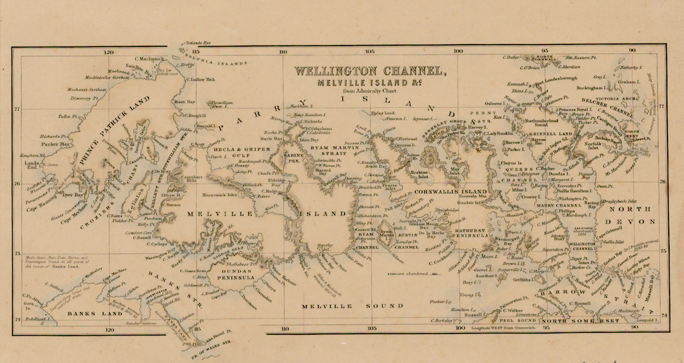
The first European to visit Melville Island was the British explorer Sir William Parry in 1819. Not only the first European to visit the island, but he was forced to spend the winter at what is now called "Winter Harbour", until August 1, 1820 owing to freeze-up of the sea.[1] The island is named for Robert Dundas, 2nd Viscount Melville who was First Sea Lord at the time. In the search for Franklin's lost expedition, its east coast was explored as far as Bradford Point by Dr. Abraham Bradford in 1851, while its north and west coasts were surveyed by Francis Leopold McClintock, Richard Vesey Hamilton and George Henry Richards in 1853.[2][3][4]
Fossil fuel deposits
Melville has surfaced as a candidate for natural gas deposits. The Island was believed to have deposits of coal and oil shale since the first half of the 20th century.[5][6] The first Canadian Arctic island exploratory well was spudded in 1961 at Winter Harbour.[7][8][9][10] It drilled Lower Paleozoic strata to a total depth of 3,823 m (12,543 ft). In the 1970s, the northern portion of the island on the east side of the Sabine Peninsula proved to contain a major gas field, known as Drake Point. The lease was owned by Panarctic Oils, a joint operation with the Canadian Government.
References
Further reading
- ^ Parry, William Edward (1821). Journal of a voyage for the discovery of a North-West passage from the Atlantic to the Pacific: performed in the years 1819-20. London: John Murray. http://books.google.com/books?id=sdM0AAAAQAAJ&printsec=frontcover&dq=William+Edward+Parry+1819#v=onepage&q&f=false.
- ^ M'Dougall, George F. (1857). The eventful voyage of H.M. discovery ship "Resolute" to the Arctic regions, in search of Sir John Franklin and the missing crews of H.M. discovery ships "Erebus" and "Terror," 1852, 1853, 1854. London: Longman, Brown, Green, Longmans, & Roberts. http://books.google.com/books?id=Bm4SAAAAYAAJ&pg=PA452&dq=The+Eventful+Voyages+of+HMS+Resolute#v=onepage&q&f=false.
- ^ Murphy, David (2004). The Arctic Fox: Francis Leopold McClintock, discoverer of the fate of Franklin. Toronto: Dundurn Press.
- ^ Savours, Ann (1999). The Search for the North West Passage. New York: St. Marten's Press.
- ^ "Canadian Arctic Islands". http://mainc.info/nth/og/pubs/prosp/chap5-eng.pdf. Retrieved 2010-06-21. "The Kanguk Formation, a basinal bituminous shale, was deposited from the Turonian to the Maastrichtian."
- ^ D.M. Edwards (1938-07-27). "Treasure of the Arctic". Christian Science Monitor. p. WM4. http://pqasb.pqarchiver.com/csmonitor_historic/access/297535292.html?dids=297535292:297535292&FMT=ABS&FMTS=ABS:AI&date=Jul+27%2C+1938&author=By+D.M.+Edwards&pub=Christian+Science+Monitor&desc=Treasure+of+the+Arctic&pqatl=google. Retrieved 2010-06-21.
- ^ "History of the Canadian Oil Industry (Key Dates)". Geo-Help Inc. http://www.geohelp.net/history.html. Retrieved 2010-06-21.
- ^ "Canada's Arctic". Government of Alberta. http://www.albertasource.ca/petroleum/industry/historic_dev_canada_arctic.html. Retrieved 2010-06-21. "The first Arctic Island well was drilled in 1961-62 by Dome Petroleum on Melville Island. Other wells followed on Cornwallis and Bathurst Islands. Although wells were abandoned, Melville Island was the site of further significant gas discoveries. Panarctic Petroleum, made up of industry and government initiatives, found gas at Drake Point on Melville Island in 1969."
- ^ "Rediscovering High Arctic riches". Vancouver Sun. 2008-10-28. http://www.canada.com/vancouversun/news/editorial/story.html?id=9d5b3935-8689-4314-b437-2299f6526bcc. Retrieved 2010-06-21. "Panarctic had discovered a huge gas field at Drake Point on Melville Island in 1968. It was so big it took 14 wells to delineate."
- ^ "Riches beckon, but the risks are high". Saskatoon Star-Phoenix. 2008-08-18. http://www.canada.com/saskatoonstarphoenix/news/national/story.html?id=dd5b3820-6b22-43a4-81a2-0d7620067a5e. Retrieved 2010-06-21. "When the federal government issued a call for bids to explore the islands of the High Arctic last year, no one stepped to the plate. Several companies discovered oil and gas fields around Melville Island in the 1970s, but eventually abandoned the projects due to high costs."
- Arctic Pilot Project (Canada). Environmental Statement : Melville Island Components. [Calgary, Alta.?]: Arctic Pilot Project, 1979.
- Barnett, D. M., S. A. Edlung, and L. A. Dredge. Terrain Characterization and Evaluation An Example from Eastern Melville Island. Paper (Geological Survey of Canada), 76-23. Ottawa: Energy, Mines and Resources Canada, 1977. ISBN 0660008122
- Buchanan, Robert A., William E. Cross, and Denis H. Thomson. Survey of the Marine Environment of Bridport Inlet, Melville Island. Calgary: Distributed by Pallister Resource Management Ltd, 1980.
- Christie, Robert Loring, and N. J. McMillan. The Geology of Melville Island, Arctic Canada. Ottawa, Canada: Geological Survey of Canada, 1994. ISBN 0660149826
- Dominion Observatory (Canada), and A. Spector. A Gravity Survey of the Melville Island Ice Caps. Canada Dominion Observatory Contributions, 07:7. 1967.
- Hodgson, D. A. Quaternary Geology of Western Melville Island, Northwest Territories. Ottawa, Canada: Geological Survey of Canada, 1992. ISBN 0660138093
- Hotzel, Charles Neish Duncan. Terrain Disturbance on the Christopher Formation, Melville Island, NWT. Ottawa: Carleton University, Dept. of Geography, 1973.
- McGregor, D. C., and M. Camfield. Middle Devonian Miospores from the Cape De Bray, Weatherall, and Hecla Bay Formations of Northeastern Melville Island, Canadian Arctic. Ottawa: Energy, Mines and Resources Canada, 1982. ISBN 0660110849
- Shea, Iris V., and Heather Watts. Deadman's Melville Island & Its Burial Ground. [Tantallon, N.S.]: Glen Margaret Pub, 2005. ISBN 0920427685
- Shearer, David Lloyd. Modern and Early Holocene Arctic Deltas, Melville Island, N.W.T., Canada. S.l: s.n.], 1974.
- Steen, O. A., and Z. D. Hora. Landscape Survey Eastern Melville Island, N.W.T. Calgary: R.M. Hardy & Associates, 1978.
- Thomas, Donald C., W. J. Edmonds, and H. J. Armbruster. Range types and their relative use by Peary caribou and muskoxen on Melville Island, NWT. Edmonton, AB: Environment Canada, Canadian Wildlife Service, 1999.
- Trettin, Hans Peter, and L. V. Hills. Lower Triassic Tar Sands of Northwestern Melville Island, Arctic Archipelago. [Ottawa]: Dept. of Energy, Mines and Resources, 1966.
External links
- Salt Dome "Craters" on Melville Island at NASA Earth Observatory
- Environment Canada Field Projects: Geese and Swans
Queen Elizabeth Islands, Nunavut and Northwest Territories, Canada Ellesmere Island: Parry Islands (major): Devon • Melville • Bathurst • Prince Patrick • Cornwallis • Mackenzie King • Borden • Cornwall • Eglinton • Graham • Lougheed • Byam Martin • Île Vanier • Cameron • Brock • North Kent • Emerald Isle • Alexander • Massey • Little Cornwallis • Coburg • Helena • Baillie-Hamilton • Griffith • Hoved • Lowther • BuckinghamParry Islands (minor): Beechey • Berkeley • Browne • Cheyne • Cocked Hat • Crescent • Des Voeux • Dundas • Edmund Walker • Eight Bears • Ekins • Fairholme • Fitzwilliam Owen • Findlay Group • Grosvenor • Hans • Houston Stewart • Hyde Parker • Île Marc • John Barrow • Margaret • Nookap • Norman Lockyer • Patterson • Philpots • Pim • Princess Royal • Skraeling • Stupart • Table • Thor • TruroSverdrup Islands (major): Sverdrup Islands (minor): Fay • Gretha • Haig-Thomas • Hat • UlvingenIslands of the Qikiqtaaluk Region Adams · Akpatok · Alfred · Allen · Amherst · Arvalik · Aulitivik · Aulitiving · Baffin · Barth · Beloeil · Bergesen · Bjarnason · Bylot · Curry · Davids · Dexterity · Diana · Edgeworth · Eider · Elder · Emmerson · Fraser · Frechette · Gyrfalcon · Hamilton · Imiqqutailaqtuuq · Kaigosuiyat · Kilian · Lady Franklin · Landslip · Liddon · Lock · Low · Marvin · Nakoaiyet · Nova Zembla · Old Squaw · Ormonde · Otrick · Pandora · Payne · Peter Richards · Pisiktarfik · Plover · Prescott · Prince Leopold · Prince of Wales · Ragged · Round · Russell · Salikuit · Saneruarsuk · Scott · Sillem · Somerset · Spicer · Stephens · Trinity · Vesey Hamilton · Vivian · Ward Hunt · Wollaston · Yeoman · YoungBelcher Islands Islands of Cumberland Sound Akulagok · Anarnittuq · Aupaluktok · Aupaluktut · Beacon · Blacklead · Clear Passage · Drum · Ekallulik · Iglunga · Imigen · Ivisa · Kaigosuit · Kangigutsak · Kekertelung · Kekertelung · Kekerten · Kekertukdjuak · Kudjak · Maktaktujanak · Miliakdjuin · Moodie · Nimigen · Nunatak · Nuvujen · Opingivik · Sanigut · Saunik · Shakshukowshee · Shakshukuk · Tesseralik · Tuapait · Ugpitimik · Utsusivik · WarehamIslands of Davis Strait Akuglek · Alikdjuak · Angijak · Durban · Idjuniving · Kekertaluk · Kekertuk · Kekerturnak · Manitung · Monumental · Nedlukseak · Nudlung · Nunatsiaq · Nuvuktik · Padloping · Pilektuak · Qaqaluit · Rock · SatigsunIslands of Foxe Basin Air Force · Bird · Bray · Deer · Foley · Igloolik · Jens Munk · Koch · Neerlonakto · North Tweedsmuir · Prince Charles · Rowley · South Tweedsmuir · Tern · White · WinterIslands of Frobisher Bay Algerine · Alligator · Anchorage · Aubrey · Augustus · Bear · Beveridge · Bishop · Brigus · Brook · Bruce · Cairn · Camp · Carter · Chase · Coffin · Crimmins · Crowell · Culbertson · Daniel · Dog · Eden · Emerick · Falk · Faris · Field · Fletcher · Frobisher's Farthest · Gabriel · Gardiner · Gay · Gross · Halford · Hantzsch · Harper · Hill · Jenvey · Kudlago · Kungo · Lefferts · Leopold · Loks Land · Long · Low · Luella · Mair · Mark · Mary · McAllister · McBride · McLaren · McLean · Metela · Mitchell · Monument · Nest · Nouyarn · Ogden · Pan · Peak · Pichit · Pike · Pink Lady · Pope · Potter · Precipice · Ptarmigan · Pugh · Qarsau · Quadrifid · Redan · Resor · Sale · Scalene · Sliver · Smith · Sybil · Thompson · WhiskukunIslands of the Gulf of Boothia Islands of Hudson Bay Islands of Hudson Strait Alareak · Aulassivik · Avingasittuit Siqinirsipangat · Beacon · Big · Black Bluff · Bush · Button · Charles · Clark · Dolphin · Dorset · Edgell · Emma · Erhardt · Forder · Glasgow · Glencoe · Goodwin · Gudmusson · Hector · High Bluff · Holdridge · Ijjurittiak · Ivisaat · Juet · King · Lacy · Lavoie · Lawson · Leading · Lee · Lower Savage · MacColl · Mallik · Middle Savage · Mill · Niels · Nottingham · Nunajuak · Nuvursiit · Nuvursirpaaraaluk · Observation · Okolli · Point · Poodlatee · Rabbit · Resolution · Sakkiak · Salisbury · Sheer · Strathcona · Uugalautiit · WishartIslands of James Bay Akimiski · Bear · Big · Cape Hope · Carey · Charlton · Grey Goose · Gull · Jacob · North Twin · Paint Hills · Solomons Temple · South Twin · Spencer · Strutton · Sunday · Trodely · Twin · Walter · WestonIslands of the Labrador Sea Brevoort · Cape Chidley · Christopher Hall · Hozier · Hudson · Ilikok · Jackson · Killiniq · Knight · Leybourne · Little Hall · Muingmak · RogersQueen Elizabeth Islands Alexander · Baillie-Hamilton · Bathurst · Beechey · Berkeley • Borden · Brock · Browne · Buckingham · Byam Martin · Cameron · Cheyne · Coburg · Cocked Hat · Cornwall · Cornwallis · Crescent · Des Voeux · Devon · Dundas · Edmund Walker · Eglinton · Ekins · Ellesmere · Emerald · Exmouth · Fairholme · Findlay Group · Garrett · Graham · Griffith · Grosvenor · Hansdisputed · Helena · Houston Stewart · Hoved · Hyde Parker · John Barrow · Little Cornwallis · Lougheed · Lowther · Mackenzie King · Marc · Margaret · Massey · Melville · Nookap · Norman Lockyer · North Kent · Patterson · Philpots · Pim · Pioneer · Prince Patrick · Princess Royal · Seymour · Skraeling · Spit · Stupart · Table · Thor · Truro · VanierSverdrup Islands Amund Ringnes · Axel Heiberg · Ellef Ringnes · Fay · Gretha · Haig-Thomas · Hat · King Christian · Meighen · Stor · UlvingenSee also Islands of the Kitikmeot Region, Islands of the Kivalliq Region. Categories:- Queen Elizabeth Islands
- Uninhabited islands of Qikiqtaaluk Region
- Bituminous sands of Canada
- Islands of the Northwest Territories
- Borders of Nunavut
- Borders of the Northwest Territories


Wikimedia Foundation. 2010.