- Beechey Island
Infobox Islands
name = Beechey Island

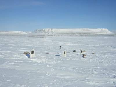
image caption = Beechey Island in 2004. Grave sites are visible in foreground.
image size =
locator
map_custom =
native name =
native name link = Inuktikut
nickname =
location =Northern Canada
coordinates = coord|74|44|N|91|55|W|display=inline,title
archipelago =Queen Elizabeth Islands Canadian Arctic Archipelago
total islands =
major islands =
area =
highest mount = 198 m (unnamed)
elevation =
country = Canada
country admin divisions title = Territory
country admin divisions = flag|Nunavut
country admin divisions title 1 =Qikiqtaaluk Region
country admin divisions 1 =
country admin divisions title 2 =
country admin divisions 2 =
country capital city =
country largest city =
country largest city population =
country leader title =
country leader name =
population = Uninhabited
population as of =
density =
ethnic groups =
additional info =Beechey Island is an
island located in theCanadian Arctic Archipelago ofNunavut ,Canada , inWellington Channel . It is separated from the southwest corner of Devon Island by Barrow Strait. [cite web |url=http://www.mobilegeographics.com:81/locations/480.html |title=Beechy Island, Barrow Strait, Nunavut |accessdate=2008-04-22 |publisher=mobilegeographics.com] Other features include Wellington Channel, Erebus Harbour, [ [http://www.google.com/search?q=Beechy+Island+-wiki+map&ie=utf-8&oe=utf-8&aq=t&rls=org.mozilla:en-US:official&client=firefox-a Beechy Island] ] and Terror Bay.The island was discovered in 1819 by Captain
William Edward Parry and was named forFrederick William Beechey (1796-1856) who was then serving as Parry'slieutenant .It is the site of several very significant events in the history of Arctic exploration. In 1845, the British explorer Sir
John Franklin , commanding a new search for theNorthwest Passage aboard HMSs Erebus and Terror, chose the protected harbor of Beechey Island for his first winter encampment. The site was not discovered until 1851 when British and American search vessels anchored nearby. They found a large stone cairn, along with the graves of three of Franklin's crew --Petty Officer John Torrington , Royal Marine PrivateWilliam Braine , and Able SeamanJohn Hartnell -- but no written record or indication of where Franklin planned to sail the next season. There are memorials to Franklin and other polar explorers and sailors on the island, includingJoseph René Bellot . [cite journal|author=Brian D. Powell|title=The memorials on Beechey Island, Nunavut, Canada: an historical and pictorial survey.|journal=Polar Record|volume=42|issue=223|pages=325-333|year=2006]In the 1980s, Canadian
forensic anthropologist Dr.Owen Beattie exhumed the three bodies, finding them to be (externally) remarkably well-preserved. Autopsies determined thatlung disease andlead poisoning were among the probable causes of death; thelead appeared to come from the thousands of lead-soldered tins of provisions with which the Franklin expedition had been supplied.Beechey Island was declared to be a "site of territorial historical significance" by the government of the
Northwest Territories in 1979. Since 1999, it has been part of the newly-created Canadian territory ofNunavut .In fiction, the explorers in Jules Verne's novel Voyages et aventures du capitaine Hatteras visit Beechey Island.
References
* [http://www.bartleby.com/69/86/B03786.html The Columbia Gazetteer of North America]
Wikimedia Foundation. 2010.
