- Devon Island
-
Devon Island 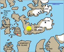
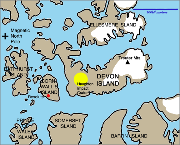
Devon Island region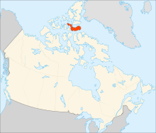
Geography Location Baffin Bay Coordinates 75°08′N 087°51′W / 75.133°N 87.85°WCoordinates: 75°08′N 087°51′W / 75.133°N 87.85°W Archipelago Queen Elizabeth Islands
Canadian Arctic ArchipelagoArea 55,247 km2 (21,331 sq mi) Area rank 27th Highest elevation 1,920 m (6,300 ft) Highest point Devon Ice Cap Country CanadaTerritory  Nunavut
Region Qikiqtaaluk Region Demographics Population Uninhabited Density 0 /km2 (0 /sq mi) 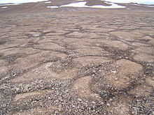 Patterned ground permafrost pattern seen on Devon Island
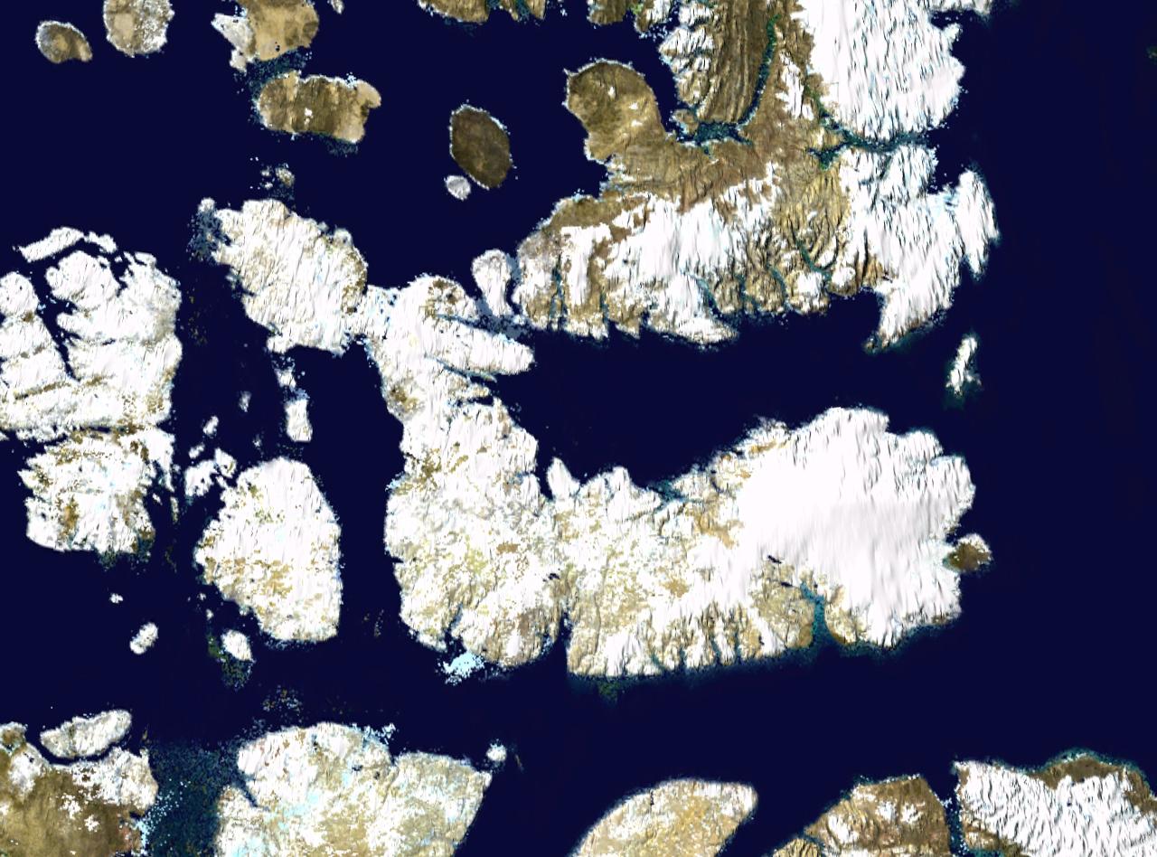
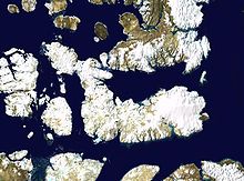 Satellite photo montage of Devon Island and its neighbours
Devon Island, claimed to be the largest uninhabited island on Earth, is located in Baffin Bay, Qikiqtaaluk Region, Nunavut, Canada. It is one of the larger members of the Canadian Arctic Archipelago, the second-largest of the Queen Elizabeth Islands, Canada's sixth largest island, and the 27th largest island in the world. It comprises 55,247 km2 (21,331 sq mi) of Precambrian gneiss and Paleozoic siltstones and shales. The highest point is the Devon Ice Cap at 1,920 m (6,300 ft) which is part of the Arctic Cordillera. Devon Island contains several small mountain ranges, such as the Treuter Mountains, Haddington Range and the Cunningham Mountains.
Because of its relatively high elevation and its extreme northern latitude, it supports only a meagre population of musk oxen and small birds and mammals; the island does support hypolith communities. Animal life is concentrated in the Truelove Lowland area of the island, which has a favourable microclimate and supports relatively lush Arctic vegetation. Temperatures during the brief (40 to 55 days) growing season seldom exceed 10 °C (50 °F), and in winter can plunge to as low as −50 °C (−58 °F). With a polar desert ecology, Devon Island receives very little precipitation.
Cape Liddon is an Important Bird Area (IBA) notable for its Black Guillemot and Northern Fulmar populations.[1] Cape Vera, another IBA site, is also noted for its Northern Fulmar population.[2]
Devon Island is also notable for the presence of the Haughton impact crater, created some 39 million years ago when a meteorite about 2 km (1.2 mi) in diameter crashed into what were then forests. The impact left a crater approximately 23 km (14 mi) in diameter, which was a lake for several million years.
Contents
History and settlement
Robert Bylot was the first European to sight the island in 1616.[3] William Edward Parry charted its south coast in 1819-20.[4] In 1850 Edwin De Haven sailed up Wellington Channel and sighted the Grinnell Peninsula.[5]
An outpost was established at Dundas Harbour in 1924, and it was leased to Hudson's Bay Company nine years later. The collapse of fur prices and the need to cut relief expenses led to the dispersal of 53 Baffin Island Inuit families on the island in 1934. It was considered a disaster due to wind conditions and the much colder climate, and the Inuit chose to leave in 1936. Dundas Harbour was populated again in the late 1940s, but it was closed again in 1951. Only the ruins of a few buildings remain.
An investigation by mysendoff.com discovered that the most northern cemetery in the world is located in Dundas Harbour on Devon island. Royal Canadian Mounted Police (RCMP) Constable Victor Maisonneuve was the first person to be buried in the island cemetery, he committed suicide on 16 June 1926 while seal hunting on the island at Crocker Bay. He was one of three officers to be transplanted to the island as part of the effort to assert Canadian sovereignty in the area. The second person to be buried on the island was RCMP constable William Robert Stephens, who accidentally shot himself while walrus hunting on 26 August 1927.[6] [7]
Two other marked graves stand in the cemetery, one is for baby Davidee Panipakichoo, who was born premature in December 1950 to one of the 53 Inuit families who were transplanted to the island. [8]
Scottish whaler John Davidson is the other individual remembered at the site. He died in 1855 while hunting seals with his crew. He passed away from tuberculosis while on the hunt. His crew members buried him at Fellfoot Point on the other side of Devon Island, which was not discovered until several Hudson Bay Company employees discovered his dislodged and washed up marker in 1935. John C. Russell, the manager of the Hudson Bay Company outpost wrote in his journal "A board was picked up on the east side of Maxwell Bay which originally had served to mark a grave, it apparently had been dislodged by the wind and blown or drifted to where it was found. It is inscribed as follows: - In memory of John Davidson, Peterhead, who died 1st August 1885, aged 42 years, S.S. 'Resolute', 'Dundee'."[9]
A replica of the headstone was placed at his resting place, and the original can be seen today at Nunatta Sunakkutaangit Museum in Iqaluit. The RCMP visits the cemetery once a year to ensure that the cemetery is properly maintained and to pay respects to the deceased. [10]
Scientific research
The Flashline MARS (Mars Arctic Research Station) project entered its third season in 2004. In July 2004, Devon Island became the temporary home for five scientists and two journalists, who were to use the Mars-like environment to simulate living and working on the Red Planet. April 2007 through 21 August 2007 was the longest simulation period and included 20 scientific studies.[11]
The Haughton crater is now considered one of Earth's best Mars analog sites. It is the summer home to a complementary scientific program, NASA's Haughton Mars Project. HMP has conducted geological, hydrological, botanical, and microbiological studies in this harsh environment since 1997.[12] HMP-2008 is the twelfth field season at Devon Island.[13]
In 2007, fossils of the seal ancestor Puijila darwini were found on the island.[14]
Notes
- ^ "Cape Liddon". bsc-eoc.org. http://www.bsc-eoc.org/iba/site.jsp?siteID=NU059. Retrieved 2009-04-23.
- ^ "Cape Vera". bsc-eoc.org. http://www.bsc-eoc.org/iba/site.jsp?siteID=NU053. Retrieved 2009-05-04.
- ^ Markham, Clements (1881). The voyages of William Baffin, 1612-1622. London: Hakluyt Society. http://books.google.com/books?id=pmcMAAAAIAAJ&printsec=frontcover&dq=William+Baffin#v=onepage&q&f=false.
- ^ Parry, William Edward (1821). Journal of a voyage for the discovery of a North-West passage from the Atlantic to the Pacific: performed in the years 1819-20. London: John Murray. http://books.google.com/books?id=sdM0AAAAQAAJ&printsec=frontcover&dq=William+Edward+Parry+1819#v=onepage&q&f=false.
- ^ Savours, Ann (1999). The Search for the North West Passage. New York: St. Marten's Press.
- ^ "Dundas Harbour". The House and other Arctic musings. http://kiggavik.typepad.com/the_house_other_arctic_mu/2005/09/dundas_harbour.html. Retrieved 19 October 2011.
- ^ Francone, Patrick. "The Most Northern Cemetery in the World". Mysendoff.com website. mysendoff.com. http://mysendoff.com/2011/07/the-most-northern-cemetery-in-the-world/. Retrieved 19 October 2011.
- ^ Francone, Patrick. "The Most Northern Cemetery in the World". Mysendoff.com website. mysendoff.com. http://mysendoff.com/2011/07/the-most-northern-cemetery-in-the-world/. Retrieved 19 October 2011.
- ^ "A Peterhead loon far awa' fae hame". The House and other Arctic Musings. http://kiggavik.typepad.com/the_house_other_arctic_mu/2006/05/a_peterhead_loo.html. Retrieved 19 October 2011.
- ^ Francone, Patrick. "The Most Northern Cemetery in the World". Mysendoff.com website. mysendoff.com. http://mysendoff.com/2011/07/the-most-northern-cemetery-in-the-world/. Retrieved 19 October 2011.
- ^ Aggerholm, Barbara (2007-08-22). "Looks like Mars, feels like Mars". The Record. http://news.therecord.com/article/231567. Retrieved 2008-05-06.
- ^ Desportes, C.; Rice, M. & Lee, P. (2007). "Periglacial polygon fields on Devon Island, High Arctic". Lunar and Planetary Science XXXVIII. http://www.lpi.usra.edu/meetings/lpsc2007/pdf/2341.pdf. Retrieved 2008-05-06.
- ^ "Gearing up for the 12th Year of Research at Haughton Crater". Mars Institute. 2008-02-23. http://www.marsonearth.org/. Retrieved 2008-05-06.
- ^ Black, Richard (2009-04-22). "'Missing link' fossil seal walked". BBC Online. http://news.bbc.co.uk/2/hi/science/nature/8012322.stm. Retrieved 2010-11-13.
References
- NASA Haughton-Mars project
- Truelove Lowland summary and pictures
- Sea islands: Atlas of Canada; Natural Resources Canada
Further reading
- Anderson, David G, and L C Bliss. 1998. "Association of Plant Distribution Patterns and Microenvironments on Patterned Ground in a Polar Desert, Devon Island, N.W.T., Canada". Arctic and Alpine Research. 30, no. 2: 97.
- Bliss, L. C. Truelove Lowland, Devon Island, Canada A High Arctic Ecosystem. Edmonton: University of Alberta Press, 1977. ISBN 0888640145(Publisher description)
- Cockell, Charles S, Pascal Lee, Andrew C Schuerger, Loretta Hidalgo, Jeff A Jones, and M Dale Stokes. 2001. "Microbiology and Vegetation of Micro-Oases and Polar Desert, Haughton Impact Crater, Devon Island, Nunavut, Canada". Arctic, Antarctic, and Alpine Research. 33, no. 3: 306.
- Lamoureux, Scott F, and Robert Gilbert. 2004. "A 750-Yr Record of Autumn Snowfall and Temperature Variability and Winter Storminess Recorded in the Varved Sediments of Bear Lake, Devon Island, Arctic Canada". Quaternary Research. 61, no. 2: 134.
- Paterson, W. S. B. "An Oxygen-Isotope Climate Record from the Devon Island Ice Cap, Arctic Canada". Nature, Vol.266,No.5602. 1977.
- Robertson, Peter, and G. D. Mason. Shatter Cones from Haughton Dome, Devon Island, Canada. 1975.
- Thorsteinsson, R., and Ulrich Mayr. The Sedimentary Rocks of Devon Island, Canadian Arctic Archipelago. Ottawa, Canada: Geological Survey of Canada, 1987. ISBN 0660123193
- Ugolini, Fiorenzo C, Giuseppe Corti, and Giacomo Certini. 2007. "Pedogenesis in the Sorted Patterned Ground of Devon Plateau, Devon Island, Nunavut, Canada". Geoderma. 136, no. 1: 87.
External links
- Photo, ca. 1900-1910, musk ox at Cape Sparbo, Devon Island
- Alpine Hydrometerology Lab, University of Lethbridge
- Arctic and Alpine Research Group, University of Alberta
- Flashline Mars Arctic Research Station (FMARS), The Mars Society
Queen Elizabeth Islands, Nunavut and Northwest Territories, Canada Ellesmere Island: Parry Islands (major): Devon • Melville • Bathurst • Prince Patrick • Cornwallis • Mackenzie King • Borden • Cornwall • Eglinton • Graham • Lougheed • Byam Martin • Île Vanier • Cameron • Brock • North Kent • Emerald Isle • Alexander • Massey • Little Cornwallis • Coburg • Helena • Baillie-Hamilton • Griffith • Hoved • Lowther • BuckinghamParry Islands (minor): Beechey • Berkeley • Browne • Cheyne • Cocked Hat • Crescent • Des Voeux • Dundas • Edmund Walker • Eight Bears • Ekins • Fairholme • Fitzwilliam Owen • Findlay Group • Grosvenor • Hans • Houston Stewart • Hyde Parker • Île Marc • John Barrow • Margaret • Nookap • Norman Lockyer • Patterson • Philpots • Pim • Princess Royal • Skraeling • Stupart • Table • Thor • TruroSverdrup Islands (major): Sverdrup Islands (minor): Fay • Gretha • Haig-Thomas • Hat • UlvingenIslands of the Qikiqtaaluk Region Adams · Akpatok · Alfred · Allen · Amherst · Arvalik · Aulitivik · Aulitiving · Baffin · Barth · Beloeil · Bergesen · Bjarnason · Bylot · Curry · Davids · Dexterity · Diana · Edgeworth · Eider · Elder · Emmerson · Fraser · Frechette · Gyrfalcon · Hamilton · Imiqqutailaqtuuq · Kaigosuiyat · Kilian · Lady Franklin · Landslip · Liddon · Lock · Low · Marvin · Nakoaiyet · Nova Zembla · Old Squaw · Ormonde · Otrick · Pandora · Payne · Peter Richards · Pisiktarfik · Plover · Prescott · Prince Leopold · Prince of Wales · Ragged · Round · Russell · Salikuit · Saneruarsuk · Scott · Sillem · Somerset · Spicer · Stephens · Trinity · Vesey Hamilton · Vivian · Ward Hunt · Wollaston · Yeoman · YoungBelcher Islands Islands of Cumberland Sound Akulagok · Anarnittuq · Aupaluktok · Aupaluktut · Beacon · Blacklead · Clear Passage · Drum · Ekallulik · Iglunga · Imigen · Ivisa · Kaigosuit · Kangigutsak · Kekertelung · Kekertelung · Kekerten · Kekertukdjuak · Kudjak · Maktaktujanak · Miliakdjuin · Moodie · Nimigen · Nunatak · Nuvujen · Opingivik · Sanigut · Saunik · Shakshukowshee · Shakshukuk · Tesseralik · Tuapait · Ugpitimik · Utsusivik · WarehamIslands of Davis Strait Akuglek · Alikdjuak · Angijak · Durban · Idjuniving · Kekertaluk · Kekertuk · Kekerturnak · Manitung · Monumental · Nedlukseak · Nudlung · Nunatsiaq · Nuvuktik · Padloping · Pilektuak · Qaqaluit · Rock · SatigsunIslands of Foxe Basin Air Force · Bird · Bray · Deer · Foley · Igloolik · Jens Munk · Koch · Neerlonakto · North Tweedsmuir · Prince Charles · Rowley · South Tweedsmuir · Tern · White · WinterIslands of Frobisher Bay Algerine · Alligator · Anchorage · Aubrey · Augustus · Bear · Beveridge · Bishop · Brigus · Brook · Bruce · Cairn · Camp · Carter · Chase · Coffin · Crimmins · Crowell · Culbertson · Daniel · Dog · Eden · Emerick · Falk · Faris · Field · Fletcher · Frobisher's Farthest · Gabriel · Gardiner · Gay · Gross · Halford · Hantzsch · Harper · Hill · Jenvey · Kudlago · Kungo · Lefferts · Leopold · Loks Land · Long · Low · Luella · Mair · Mark · Mary · McAllister · McBride · McLaren · McLean · Metela · Mitchell · Monument · Nest · Nouyarn · Ogden · Pan · Peak · Pichit · Pike · Pink Lady · Pope · Potter · Precipice · Ptarmigan · Pugh · Qarsau · Quadrifid · Redan · Resor · Sale · Scalene · Sliver · Smith · Sybil · Thompson · WhiskukunIslands of the Gulf of Boothia Islands of Hudson Bay Islands of Hudson Strait Alareak · Aulassivik · Avingasittuit Siqinirsipangat · Beacon · Big · Black Bluff · Bush · Button · Charles · Clark · Dolphin · Dorset · Edgell · Emma · Erhardt · Forder · Glasgow · Glencoe · Goodwin · Gudmusson · Hector · High Bluff · Holdridge · Ijjurittiak · Ivisaat · Juet · King · Lacy · Lavoie · Lawson · Leading · Lee · Lower Savage · MacColl · Mallik · Middle Savage · Mill · Niels · Nottingham · Nunajuak · Nuvursiit · Nuvursirpaaraaluk · Observation · Okolli · Point · Poodlatee · Rabbit · Resolution · Sakkiak · Salisbury · Sheer · Strathcona · Uugalautiit · WishartIslands of James Bay Akimiski · Bear · Big · Cape Hope · Carey · Charlton · Grey Goose · Gull · Jacob · North Twin · Paint Hills · Solomons Temple · South Twin · Spencer · Strutton · Sunday · Trodely · Twin · Walter · WestonIslands of the Labrador Sea Brevoort · Cape Chidley · Christopher Hall · Hozier · Hudson · Ilikok · Jackson · Killiniq · Knight · Leybourne · Little Hall · Muingmak · RogersQueen Elizabeth Islands Alexander · Baillie-Hamilton · Bathurst · Beechey · Berkeley • Borden · Brock · Browne · Buckingham · Byam Martin · Cameron · Cheyne · Coburg · Cocked Hat · Cornwall · Cornwallis · Crescent · Des Voeux · Devon · Dundas · Edmund Walker · Eglinton · Ekins · Ellesmere · Emerald · Exmouth · Fairholme · Findlay Group · Garrett · Graham · Griffith · Grosvenor · Hansdisputed · Helena · Houston Stewart · Hoved · Hyde Parker · John Barrow · Little Cornwallis · Lougheed · Lowther · Mackenzie King · Marc · Margaret · Massey · Melville · Nookap · Norman Lockyer · North Kent · Patterson · Philpots · Pim · Pioneer · Prince Patrick · Princess Royal · Seymour · Skraeling · Spit · Stupart · Table · Thor · Truro · VanierSverdrup Islands Amund Ringnes · Axel Heiberg · Ellef Ringnes · Fay · Gretha · Haig-Thomas · Hat · King Christian · Meighen · Stor · UlvingenSee also Islands of the Kitikmeot Region, Islands of the Kivalliq Region.Categories:- Baffin Bay
- Islands of Qikiqtaaluk Region
- Queen Elizabeth Islands
- Uninhabited islands of Qikiqtaaluk Region
- Canadian Arctic Archipelago
- Former populated places in Arctic Canada
- Former populated places in the Qikiqtaaluk Region


Wikimedia Foundation. 2010.