- Clyde River, Nunavut
-
Clyde River
ᑲᖏᖅᑐᒑᐱᒃ
Kangiqtugaapik— Hamlet — Clyde River 1997 
SealCoordinates: 70°28′26″N 068°35′10″W / 70.47389°N 68.58611°WCoordinates: 70°28′26″N 068°35′10″W / 70.47389°N 68.58611°W Country  Canada
Territory  Nunavut
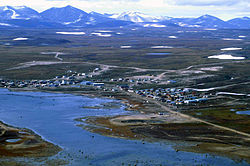
Region Qikiqtaaluk Region Electoral district Uqqummiut Government[1][2] - Mayor Apiusie Apak - MLA James Arreak Area[3] - Total 106.48 km2 (41.1 sq mi) Elevation[4] 27 m (89 ft) Population (2006)[3] - Total 820 - Density 7.7/km2 (19.9/sq mi) Time zone EST (UTC-5) - Summer (DST) EDT (UTC-4) Canadian Postal code X0A 0E0 Area code(s) 867 Clyde River (Inuktitut: Kanngiqtugaapik, Syllabics: ᑲᖏᖅᑐᒑᐱᒃ) is an Inuit hamlet located on the shore of Baffin Island's Patricia Bay, off Clyde Inlet,[5] an arm of Davis Strait in the Qikiqtaaluk Region, of Nunavut Canada. It lies in the Baffin Mountains which in turn form part of the Arctic Cordillera mountain range. The community is served by air and by annual supply sealift.
The community is served by Quluaq School, two stores, a new arena, a community hall, a church, health center, hotel and Clyde River Airport with regular flights to Iqaluit and Pond Inlet.
Contents
Demographics
As of the 2006 census the population was 820 an increase of 4.5% from the 2001 census.[3] About half of the people here are under the age of 18 and the population is growing rapidly.
Geography
It is located on a flood plain, surrounded by spectacular fiords that stretch all the way into the Barnes Icecap. The mountains, icebergs and glaciers in the Clyde River area attract rock and ice climbers from around the world.
There is also a multitude of animals to be seen, including Barren-ground Caribou, Narwhals, Polar Bears and other sea mammals. The proposed "Igaliqtuuq National Wildlife Area", which would be a protected Bowhead Whale sanctuary, is located in Isabella Bay. Clyde River will become the location for Nunavut's New Cultural school which will be complete in 2009.
Climate
Climate data for Clyde River Airport Month Jan Feb Mar Apr May Jun Jul Aug Sep Oct Nov Dec Year Humidex 2.2 1.7 -2.0 7.2 8.5 15.0 21.4 20.7 14.4 34.4 1.7 1.7 21.4 Record high °C (°F) 3.3
(37.9)3.3
(37.9)−1
(30.2)11.7
(53.1)8.9
(48.0)17.8
(64.0)22.2
(72.0)20.0
(68.0)14.6
(58.3)10.3
(50.5)6.7
(44.1)2.8
(37.0)22.2
(72.0)Average high °C (°F) −24.2
(−11.6)−25.6
(−14.1)−22.7
(−8.9)−14.1
(6.6)−4.3
(24.3)3.6
(38.5)8.2
(46.8)7.1
(44.8)2.4
(36.3)−4.5
(23.9)−13.8
(7.2)−21
(−5.8)−9.08
(15.67)Daily mean °C (°F) −28.1
(−18.6)−29.6
(−21.3)−27.2
(−17.0)−19
(−2.2)−8.5
(16.7)0.7
(33.3)4.4
(39.9)3.9
(39.0)0.0
(32.0)−7.6
(18.3)−17.5
(0.5)−24.8
(−12.6)−12.78
(9.01)Average low °C (°F) −31.9
(−25.4)−33.4
(−28.1)−31.5
(−24.7)−23.9
(−11.0)−12.7
(9.1)−2.3
(27.9)0.6
(33.1)0.6
(33.1)−2.4
(27.7)−10.6
(12.9)−21
(−5.8)−28.5
(−19.3)−16.42
(2.45)Record low °C (°F) −50.2
(−58.4)−50.1
(−58.2)−47.8
(−54.0)−41.1
(−42.0)−31.1
(−24.0)−17.2
(1.0)−6.8
(19.8)−5.6
(21.9)−16.1
(3.0)−28.7
(−19.7)−39.5
(−39.1)−45
(−49.0)−50.2
(−58.4)Wind chill −59.5 −62.4 −58.1 −48.9 −34.4 −20 −10.5 −9.5 −21.2 −36.4 −46.7 −55.3 −62.4 Precipitation mm (inches) 8.8
(0.346)6.3
(0.248)7.4
(0.291)15.6
(0.614)17.7
(0.697)16.5
(0.65)22.3
(0.878)31.4
(1.236)33.0
(1.299)37.7
(1.484)22.9
(0.902)13.5
(0.531)233.0
(9.173)Rainfall mm (inches) 0.0
(0)0.0
(0)0.0
(0)0.0
(0)0.4
(0.016)3.6
(0.142)16.1
(0.634)24.8
(0.976)7.3
(0.287)0.3
(0.012)0.0
(0)0.0
(0)52.6
(2.071)Snowfall cm (inches) 9.5
(3.74)7.4
(2.91)8.3
(3.27)17.4
(6.85)19.4
(7.64)13.5
(5.31)6.2
(2.44)7.0
(2.76)29.4
(11.57)43.9
(17.28)25.9
(10.2)15.1
(5.94)202.7
(79.8)Avg. precipitation days 7.1 6.3 6.6 8.5 10.3 6.9 7.6 10.6 14 16.7 11.6 8.1 114.4 Avg. rainy days 0.0 0.0 0.0 0.0 0.31 1.6 6.6 9.1 3.8 0.34 0.1 0.03 21.8 Avg. snowy days 7.3 6.6 6.8 8.7 10.5 5.6 2.4 3.3 12 17 11.8 8.4 100.3 Sunshine hours 0.0 56.1 175.6 253.3 264.1 273.4 279.0 161.6 83.9 45.5 0.0 0.0 1,592.5 Source: 1971-2000 Environment Canada[6] See also
References
- ^ Hamlets elect new councils
- ^ Election Results - 2008 General Election
- ^ a b c 2006 census
- ^ Elevation at airport. Canada Flight Supplement. Effective 0901Z 20 October 2011 to 0901Z 15 December 2011
- ^ "Nunavut Communities". 2007 Western Premiers' Conference. gov.nu.ca. http://www.gov.nu.ca/wpc/communities.html. Retrieved 2008-09-22.
- ^ Environment Canada—Canadian Climate Normals 1971–2000. Retrieved 22 June 2011.
Further reading
- Gearheard S, W Matumeak, I Angutikjuaq, J Maslanik, HP Huntington, J Leavitt, DM Kagak, G Tigullaraq, and RG Barry. 2006. ""It's Not That Simple": A Collaborative Comparison of Sea Ice Environments, Their Uses, Observed Changes, and Adaptations in Barrow, Alaska, USA, and Clyde River, Nunavut, Canada". Ambio. 35, no. 4: 203-11.
- Igutaq Group Clyde River. Igutaq Group Clyde River Prints/Estampes, 1981. Ottawa: Igutaq Group, 1981. ISBN 092023447X
- Nickels, Scot. Northern Conservation and Tourism The Perceptions of Clyde River Inuit. Ottawa: National Library of Canada, 1992. ISBN 0315804246
- Sekerak, A. D. A Community Plan to Increase Fish Populations Near Clyde River, N.W.T. [Yellowknife, N.W.T.]: The Dept, 1991.
External links
 Subdivisions of Nunavut
Regions Communities Arctic Bay · Arviat · Baker Lake · Bathurst Inlet · Cambridge Bay · Cape Dorset · Chesterfield Inlet · Clyde River · Coral Harbour · Gjoa Haven · Grise Fiord · Hall Beach · Igloolik · Iqaluit Apex · Kimmirut · Kugaaruk · Kugluktuk · Pangnirtung · Pond Inlet · Qikiqtarjuaq · Rankin Inlet · Repulse Bay · Resolute · Sanikiluaq · Taloyoak · Whale CoveWeather stations
and Canadian Forces basesMine sites Proposed Baffinland Iron MineUnder construction Defunct Bent Horn Mine · Cullaton Lake/Shear Lake Mine · Jericho Diamond Mine · Lupin Mine · Nanisivik Mine · Polaris mine · Rankin Inlet MineDEW line and NWS sites Bernard Harbour · Bray Island · Brevoort Island · Broughton Island · Byron Bay · Cambridge Bay · Cape Dyer · Cape Hooper · Cape Mcloughlin · Cape Mercy · Cape Peel West · Cape Young · Clifton Point · Clinton Point · Croker River · Dewar Lakes · Durban Island · Edinburgh Island · Ekalugad · Gjoa Haven · Gladman Point · Hall Beach · Harding River · Hat Island · Jenny Lind Island · Kangok Fjord · Keats Point · Keith Bay · Kivitoo · Lady Franklin Point · Lailor River · Loks Land · Longstaff Bluff · Mackar Inlet · Matheson Point · Nudluardjuk Lake · Pelly Bay · Resolution Island · Ross Point · Rowley Island · Scarpa Lake · Shepherd Bay · Simpson Lake · Sturt PointFormer Amadjuak · Brooman Point Village · Craig Harbour · Dundas Harbour · Iglunga · Killiniq · Native Point · Nuwata · Padlei · Port Leopold · TavaniHudson's Bay Company
trading postsAmadjuak · Apex · Arctic Bay · Baker Lake · Bathurst Inlet · Bay Chimo · Belcher Islands · Blacklead Island · Cambridge Bay · Cape Dorset · Charlton Island Depot · Chesterfield Inlet · Clyde River · Coats Island · Dundas Harbour · Eskimo Point · Fort Hearne · Fort Ross · Frobisher Bay · Gjoa Haven · Igloolik · Kent Peninsula · King William Island · Kugaryuak · Lake Harbour · Mansel Island · Nueltin House · Padley · Pangnirtung · Pangnirtung Fox Farm · Perry River · Ponds Inlet · Port Leopold · Port Burwell · Repulse Bay · Southampton Island · Tavane · Tree River · Wager InletCategories:- Baffin Island
- Arctic Cordillera
- Populated places in Arctic Canada
- Hudson's Bay Company trading posts in Nunavut
- Hamlets in the Qikiqtaaluk Region
Wikimedia Foundation. 2010.


