- Pond Inlet
-
Pond Inlet
Mittimatalik
ᒥᑦᑎᒪᑕᓕᒃPond Inlet in 2006
 Pond Inlet
Coordinates: 72°41′57″N 077°57′33″W / 72.69917°N 77.95917°WCoordinates: 72°41′57″N 077°57′33″W / 72.69917°N 77.95917°W Country  Canada
Territory  Nunavut
Region Qikiqtaaluk Region Electoral district Tunnuniq Government[1][2] - Type Hamlet Council - Mayor Jaykolasie Killiktee[3] - MLAs James Arvaluk Area[4] - Total 173.36 km2 (66.9 sq mi) Elevation[5] 55 m (180 ft) Population (2006)[4] - Total 1,315 - Density 7.6/km2 (19.6/sq mi) Time zone EST (UTC-5) - Summer (DST) EDT (UTC-4) Canadian Postal code X0A 0S0 Area code(s) 867 Website www.pondinlet.ca Pond Inlet (Inuktitut: Mittimatalik, in English the place where Mitima is buried) is a small, predominantly Inuit community in the Qikiqtaaluk Region of Nunavut, Canada and is located at the top of Baffin Island. As of the 2006 census the population was 1,315, an increase of 7.8% from the 2001 census[4] making it the largest of the four hamlets above the 72nd parallel. Pond Inlet was named in 1818 by explorer John Ross for John Pond, an English astronomer. The mayor is Abraham Kublu.[6] Toonoonik-Sahoonik Cooperative Limited most often referred to simply as the Co-op, also operates a local hotel and other endeavors.
Contents
Economy
Its economy is largely service based with government as the largest employer. Small businesses that serve the community, tourism, and art work though are also found.
The local co-operative, Tununiq Sauniq Co-op, is the largest co-op in Nunavut. It serves the community by managing contracts and delivering goods and services to the citizens of Pond Inlet. Some of the services T.S. Co-op provides are; school bus services, Canada Post services, First Air Services, Qilaut Heavy Equiptment Rentals and services, Sauniq Hotel (largest in community), Construction contracts, T.V. Cable Services, a grocery and department store, Yamaha Snowmobile and ATV repair shop, and others.
The economy is expected to boom once the Mary River Iron Ore MIne is in full operation. The mine site is approximately 160 km west/south-west of the community and still in it's developmental stage.
As a tourist destination, Pond Inlet is considered one of Canada's "jewels of the North". It is one of the most picturesque communities with mountainous ranges viewable from all directions. Icebergs are most often accessible from the community within walking distance or a short snowmobile ride in winter. Pond Inlet boasts a nearby floe edge, several dozen glaciers, explorable ice caves, and many grand and picturesque inlets. Barren-ground Caribou, Ringed Seal, Narwhals and Polar Bears are just some of the wildlife that can be encountered while traveling out on the land. Nunavut also boasts one of Canada's newest national parks named after a majestic glacier that can be viewed north of the community on Bylot Island; Sirmilik National Park.
Transportation
Pond Inlet is most readily accessible by airplane through a connection in Iqaluit, Nunavut's capital to Pond Inlet Airport. The ocean is ice free for as long as three and a half months when tourist cruise ships visit and goods can be transported to the community by sealift cargo carrying ships. Fresh food such as fruits, vegetables and milk is flown from Montreal to Pond Inlet several times a week, a distance of about 2,500 km (1,600 mi).
Because of such great distances the cost of food and other materials such as construction supplies can be much higher than that of southern Canada. Milk is approximately $3.75/L, and soda can be as much as $4.50/can. 1.8 L of Ocean Spray juice was as high as $64.99 in September 2004.
Although the community is not more than 2.5 km (1.6 mi) long, snowmobiles and ATV four wheelers are the main modes of transportation. With the decentralization of the Nunavut government and increased economic opportunities in the community, the number of vehicles has been increasing tenfold.
Education
Pond Inlet has two schools: Ulaajuk (elementary school) and Nasivvik (junior and high school). There is also Nunavut Arctic College which provides courses and programs for adults.
Climate
Pond Inlet has a polar arctic climate with long cold winters and short cool summers. Pond Inlet's average high for the year is −11.5 °C (11.3 °F) while the average low for the year is −18.6 °C (−1.5 °F). The record high for Pond Inlet is 25.7 °C (78.3 °F) on 5 March 1993. The record low for Pond Inlet is −53.9 °C (−65.0 °F) on 12 February 1979.[7]
Climate data for Pond Inlet Airport Month Jan Feb Mar Apr May Jun Jul Aug Sep Oct Nov Dec Year Humidex 3.6 -4.0 -0.8 3.9 9.4 15.0 22.0 18.8 11.8 6.0 0.9 -3.2 22.0 Record high °C (°F) 3.7
(38.7)21.5
(70.7)25.7
(78.3)3.9
(39.0)12.1
(53.8)15.5
(59.9)22.0
(71.6)18.5
(65.3)11.9
(53.4)6.5
(43.7)2.0
(35.6)−1.7
(28.9)25.7
(78.3)Average high °C (°F) −28.8
(−19.8)−30.6
(−23.1)−26.4
(−15.5)−17.7
(0.1)−5.8
(21.6)4.7
(40.5)9.8
(49.6)7.2
(45.0)1.2
(34.2)−8
(17.6)−18.5
(−1.3)−25
(−13.0)−11.5 Daily mean °C (°F) −32.4
(−26.3)−34.1
(−29.4)−30.3
(−22.5)−22.1
(−7.8)−9.9
(14.2)1.8
(35.2)6.0
(42.8)4.2
(39.6)−1.4
(29.5)−11.4
(11.5)−22.4
(−8.3)−28.7
(−19.7)−15.1 Average low °C (°F) −35.9
(−32.6)−37.5
(−35.5)−33.9
(−29.0)−26.5
(−15.7)−13.9
(7.0)−1.1
(30.0)2.1
(35.8)1.2
(34.2)−4
(24.8)−14.7
(5.5)−26.1
(−15.0)−32.4
(−26.3)−18.6 Record low °C (°F) −49.8
(−57.6)−53.9
(−65.0)−49
(−56.2)−40.2
(−40.4)−28.4
(−19.1)−14
(6.8)−6.1
(21.0)−6.1
(21.0)−16.4
(2.5)−30.1
(−22.2)−42
(−43.6)−45.5
(−49.9)−53.9
(−65.0)Wind chill −64.8 −68.5 −60.3 −51.4 −36.2 −20.7 −7.5 −17.8 −25 −42 −51.6 −58.6 −68.5 Precipitation mm (inches) 5.7
(0.224)4.3
(0.169)8.0
(0.315)10.7
(0.421)9.6
(0.378)15.8
(0.622)31.1
(1.224)36.9
(1.453)20.8
(0.819)23.4
(0.921)16.1
(0.634)8.4
(0.331)190.8
(7.512)Rainfall mm (inches) 0.0
(0)0.0
(0)0.0
(0)0.0
(0)0.2
(0.008)11.7
(0.461)30.5
(1.201)32.9
(1.295)8.4
(0.331)1.3
(0.051)0.4
(0.016)0.0
(0)85.4
(3.362)Snowfall cm (inches) 7.3
(2.87)5.6
(2.2)10.1
(3.98)13.9
(5.47)14.2
(5.59)5.3
(2.09)0.5
(0.2)3.9
(1.54)16.7
(6.57)32.8
(12.91)22.4
(8.82)11.8
(4.65)144.5
(56.89)Avg. precipitation days 5.7 4.8 7.6 7.1 6.5 6.5 8.7 10.9 8.6 12.1 9.8 7.1 95.4 Avg. rainy days 0.0 0.0 0.0 0.0 0.13 4.3 8.5 9.8 2.2 0.15 0.04 0.0 25.12 Avg. snowy days 5.7 4.9 7.7 7.0 6.3 2.9 0.26 1.4 6.6 12.0 9.8 7.2 71.76 Source: 1971-2000 Environment Canada[7] Image gallery
-
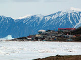
Pond Inlet in mid June of 2005 from Salmon Creek, 3.5 kms West of the Hamlet
-
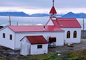
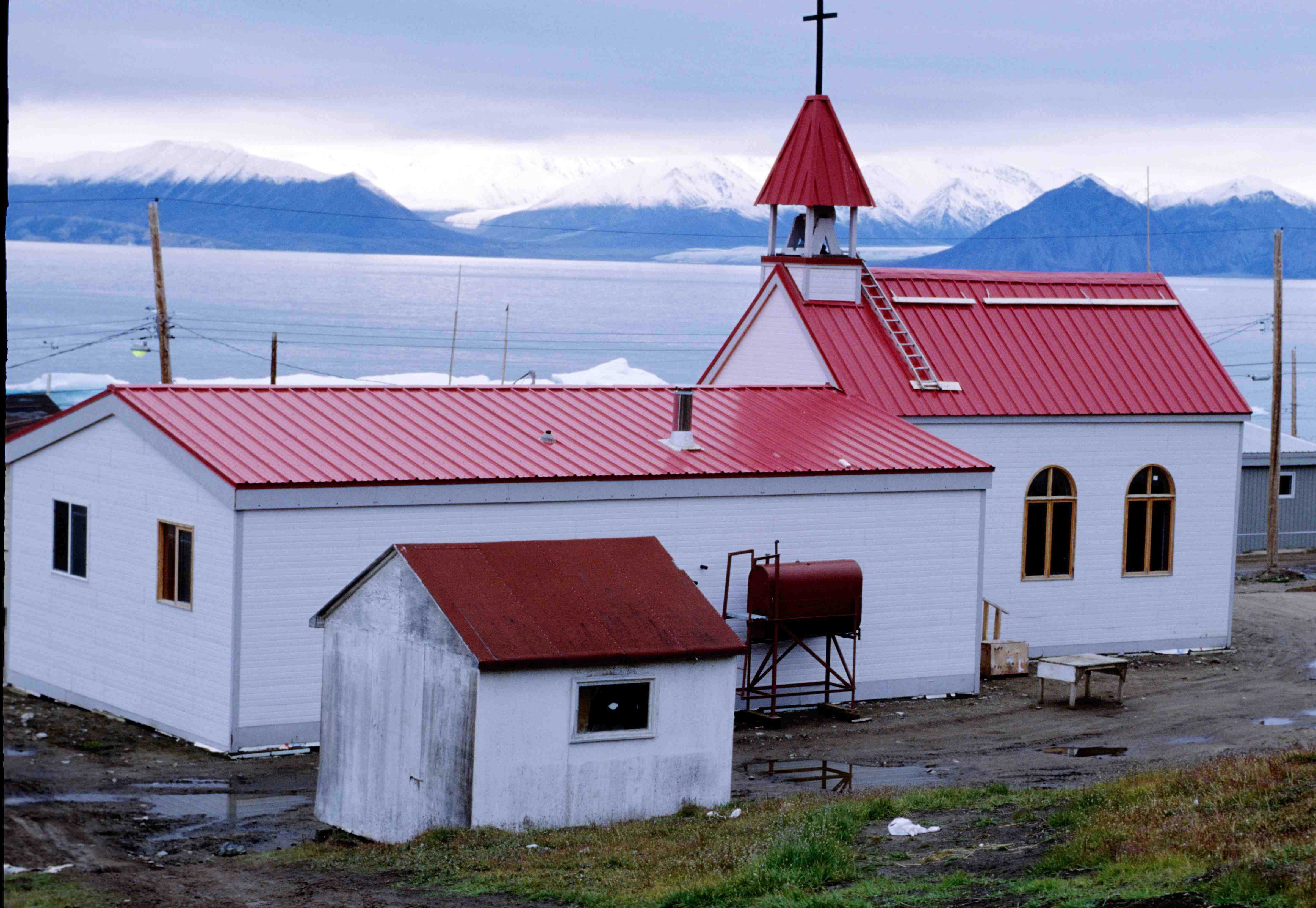
Catholic church
See also
References
- ^ Hamlets elect new councils
- ^ Election Results - 2008 General Election
- ^ Pond Inlet, Gjoa Haven and Taloyoak elect new mayors
- ^ a b c 2006 census
- ^ Elevation at airport. Canada Flight Supplement. Effective 0901Z 20 October 2011 to 0901Z 15 December 2011
- ^ Hamlet of Pond Inlet
- ^ a b Environment Canada—Canadian Climate Normals 1971–2000. Retrieved 22 June 2011.
Further reading
- Bradstreet, Michael S. W. Studies Near the Pond Inlet Ice Edge Occurrence, Habitat Use, and Behavior of Seabirds, Marine Mammals, and Arctic Cod. Calgary: Petro-Canada, 1980.
- Finley, K. J., and Elizabeth J. Gibb. Summer Diet of the Narwhal (Monodon Monoceros) in Pond Inlet, Northern Baffin Island. Toronto: LGL Limited for Petro-Canada Exploration Inc., Calgary, 1982.
- Gourdeau, Eric. Notes on the Social Impact of Panarctic's Employment Policy in Arctic Bay and Pond Inlet. [Montreal]: Arctic Institute of North America, 1973.
- Grant, Shelagh D. Arctic Justice On Trial for Murder, Pond Inlet, 1923. McGill-Queen's native and northern series, 33. Montréal, QC: McGill-Queen's University Press, 2002. ISBN 0773523375
- Grigsby, Michael. Eskimos of Pond Inlet. [Great Britain]: Granada TV, 1975.
- Jackson, G. D., A. Davidson, and W. C. Morgan. Geology of the Pond Inlet Map-Area, Baffin Island, District of Franklin. Paper (Geological Survey of Canada), 74-25. Ottawa: Geological Survey of Canada, Dept. of Energy, Mines and Resources, 1975.
- MacFarlane, I. C. The Effects of Deformation on the Structure of Sea Ice, Pond Inlet, N.W.T. A Contract Report. St. John's, Nfld: Centre for Cold Ocean Resources Engineering, Memorial University of Newfoundland, 1983.
- Nashook, Elijah. Pond Inlet Airstrip Extension Correspondence between Elijah Nashook, Mayor of the Hamlet of Pond Inlet and the Government of the Northwest Territories. Yellowknife?, N.W.T.: Government of the Northwest Territories?, 1987.
- Northwest Territories. Pond Inlet (Mittimatalik). Northwest Territories data sheets. 1986.
- Pond Inlet Education Council, and Baffin Divisional Board of Education. Nanuit Miksaanut. [Iqaluit, N.W.T.]: Pond Inlet Education Council, 1980. ISBN 0920245668
- Remote Community Demonstration Program (Canada), and Peter J. Poole. A Study to Determine Off-Oil Options for Pond Inlet, N.W.T., with Special Emphasis on the Prospects for Developing Coal Reserves. Ottawa: The Program, 1983.
- Romer, Mark. Pond Inlet Gardens A Report on the Design and Operation of a Solar Greenhouse on North Baffin Island, NWT, with Particular Reference to Economic Viability of Vegetable Production for Arctic Regions. Outremont, Qué: Romer, 1987.
- Soberman, D. A. Report to the Canadian Human Rights Commission on the Complaints of the Inuit People Relocated from Inukjuak and Pond Inlet, to Grise Fiord and Resolute Bay in 1953 and 1955. S.l: s.n.], 1991.
External links
- Official site
- Pond Inlet at the Canadian Arctic Collections
- Sirmilik National Park
- Pond Inlet at the Qikiqtani Inuit Association
 Subdivisions of Nunavut
Regions Communities Arctic Bay · Arviat · Baker Lake · Bathurst Inlet · Cambridge Bay · Cape Dorset · Chesterfield Inlet · Clyde River · Coral Harbour · Gjoa Haven · Grise Fiord · Hall Beach · Igloolik · Iqaluit Apex · Kimmirut · Kugaaruk · Kugluktuk · Pangnirtung · Pond Inlet · Qikiqtarjuaq · Rankin Inlet · Repulse Bay · Resolute · Sanikiluaq · Taloyoak · Whale CoveWeather stations
and Canadian Forces basesMine sites Proposed Baffinland Iron MineUnder construction Defunct Bent Horn Mine · Cullaton Lake/Shear Lake Mine · Jericho Diamond Mine · Lupin Mine · Nanisivik Mine · Polaris mine · Rankin Inlet MineDEW line and NWS sites Bernard Harbour · Bray Island · Brevoort Island · Broughton Island · Byron Bay · Cambridge Bay · Cape Dyer · Cape Hooper · Cape Mcloughlin · Cape Mercy · Cape Peel West · Cape Young · Clifton Point · Clinton Point · Croker River · Dewar Lakes · Durban Island · Edinburgh Island · Ekalugad · Gjoa Haven · Gladman Point · Hall Beach · Harding River · Hat Island · Jenny Lind Island · Kangok Fjord · Keats Point · Keith Bay · Kivitoo · Lady Franklin Point · Lailor River · Loks Land · Longstaff Bluff · Mackar Inlet · Matheson Point · Nudluardjuk Lake · Pelly Bay · Resolution Island · Ross Point · Rowley Island · Scarpa Lake · Shepherd Bay · Simpson Lake · Sturt PointFormer Amadjuak · Brooman Point Village · Craig Harbour · Dundas Harbour · Iglunga · Killiniq · Native Point · Nuwata · Padlei · Port Leopold · TavaniHudson's Bay Company
trading postsAmadjuak · Apex · Arctic Bay · Baker Lake · Bathurst Inlet · Bay Chimo · Belcher Islands · Blacklead Island · Cambridge Bay · Cape Dorset · Charlton Island Depot · Chesterfield Inlet · Clyde River · Coats Island · Dundas Harbour · Eskimo Point · Fort Hearne · Fort Ross · Frobisher Bay · Gjoa Haven · Igloolik · Kent Peninsula · King William Island · Kugaryuak · Lake Harbour · Mansel Island · Nueltin House · Padley · Pangnirtung · Pangnirtung Fox Farm · Perry River · Ponds Inlet · Port Leopold · Port Burwell · Repulse Bay · Southampton Island · Tavane · Tree River · Wager InletCategories:- Baffin Island
- Populated places in Arctic Canada
- Hudson's Bay Company trading posts in Nunavut
- Hamlets in the Qikiqtaaluk Region
-


Wikimedia Foundation. 2010.