- Repulse Bay, Nunavut
-
Repulse Bay
Naujaat
ᓇᐅᔮᑦRepulse Bay in October
 Repulse Bay
Coordinates: 66°31′19″N 086°14′06″W / 66.52194°N 86.235°WCoordinates: 66°31′19″N 086°14′06″W / 66.52194°N 86.235°W Country  Canada
Territory  Nunavut
Region Kivalliq Region Electoral district Akulliq Government[1][2] – Type Hamlet Council – Mayor Hugh Haqpi[3] – MLA John Ningark Area[4] – Total 423.74 km2 (163.6 sq mi) Elevation[5] 24 m (79 ft) Population (2006)[4] – Total 748 – Density 1.8/km2 (4.6/sq mi) Time zone EST (UTC-6) – Summer (DST) EDT (UTC-5) Canadian Postal code X0C 0H0 Area code(s) 867 Repulse Bay (Inuktitut: Naujaat ᓇᐅᔮᑦ literally “seagulls’ nesting place”) is an Inuit hamlet located on the shore of Hudson Bay, Kivalliq Region, in Nunavut, Canada.
Contents
Location and wildlife
 Arctic Circle arch
The hamlet is located exactly on the Arctic Circle, on the north shore of Repulse Bay and on the south shore of the Rae Isthmus. Transport to the community is provided primarily by air and by an annual sealift. Naujaat is home to a wide variety of animals including polar bears, caribou, seals, whales, and walrus. There are also approximately one hundred species of birds in the area, including gyrfalcons and peregrine falcons.
History
Naujaat is translated into English variously as "seagull fledgling," "seagull resting place" or "seagulls' nesting place," named after a cliff five kilometres to the north, where seagulls, migrating from the south each June, make their nests. Naujaat was first visited by Europeans in the 1740s, and by the late 1800s it became a popular whaling ground for American and Scottish whalers. Many Naujaat Inuit residents worked on board these whaling vessels from the south. Although there are various theories as to the origin of the English name "Repulse Bay," many attribute the name to Christopher Middleton, who when searching for the Northwest Passage in 1742 discovered that the bay was not a route out of Hudson Bay, but rather a cul-de-sac. He is claimed to have called it the “Bay of Repulse, the bay where I was pushed away”. Others believe that the name comes from an eighteenth-century English vessel named "Repulse"[disambiguation needed
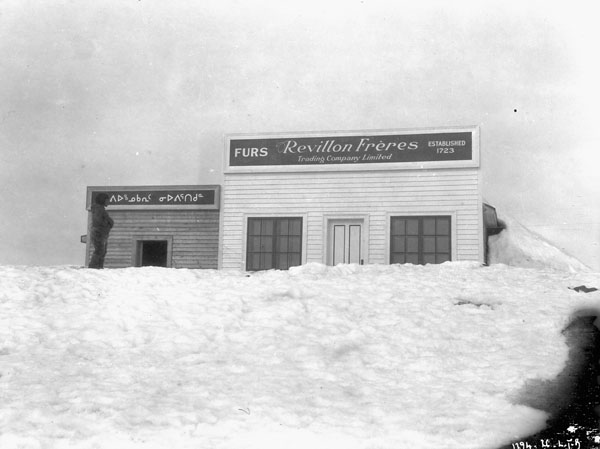
 ] which visited the area. The Hudson's Bay Company opened a post in Repulse Bay about 1916 and in 1923 a rival fur trading company, Revillon Freres, opened a post. A Roman Catholic Mission was built in 1932. Naujaat was formerly part of the District of Keewatin and the Keewatin Region; in 1999 the area became part of the Kivalliq Region.
 Revillon Frères post, Repulse Bay, 1926.
Naujaat (Repulse Bay) today
As of the 2006 census, the population was 748, an increase of 22.2% from the 2001 census.[4] The Naujaat community continues to rely on traditional sealing, fishing, hunting, trapping, and carving for their livelihood, together with tourism. Naujaat is known for its Inuit artists, especially carvers (typically creating small realist animal sculptures of ivory, soapstone, marble and antler), as well as jewellery and crafts. Its people are the 'Aivilingmiut'.
See also
References
- ^ Hamlets elect new councils
- ^ Election Results - 2008 General Election
- ^ Election results
- ^ a b c 2006 census
- ^ Elevation at airport. Canada Flight Supplement. Effective 0901Z 20 October 2011 to 0901Z 15 December 2011
- inuitarteskimoart.com [1]
- thecanadianencyclopedia.com [2]
- planetware.com [3]
- atlas.nrcan.gc.ca [4]
- arcticco-op.com [5]
- repulsebayhotel.com [6]
- gov.nu.ca/Nunavut [7]
- arcticomi.ca [8]
- bbs.keyhole.com [9]
External links
- "CONDUCTING A TRADING POST FARTHEST NORTH - A LIFE THAT GETS INTO THE BLOOD OF A MAN" - May 18, 1924 New Bedford Sunday Standard article on the Repulse Bay HBC post in the early 1920s.
 Subdivisions of Nunavut
Regions Communities Arctic Bay · Arviat · Baker Lake · Bathurst Inlet · Cambridge Bay · Cape Dorset · Chesterfield Inlet · Clyde River · Coral Harbour · Gjoa Haven · Grise Fiord · Hall Beach · Igloolik · Iqaluit Apex · Kimmirut · Kugaaruk · Kugluktuk · Pangnirtung · Pond Inlet · Qikiqtarjuaq · Rankin Inlet · Repulse Bay · Resolute · Sanikiluaq · Taloyoak · Whale CoveWeather stations
and Canadian Forces basesMine sites Proposed Baffinland Iron MineUnder construction Defunct Bent Horn Mine · Cullaton Lake/Shear Lake Mine · Jericho Diamond Mine · Lupin Mine · Nanisivik Mine · Polaris mine · Rankin Inlet MineDEW line and NWS sites Bernard Harbour · Bray Island · Brevoort Island · Broughton Island · Byron Bay · Cambridge Bay · Cape Dyer · Cape Hooper · Cape Mcloughlin · Cape Mercy · Cape Peel West · Cape Young · Clifton Point · Clinton Point · Croker River · Dewar Lakes · Durban Island · Edinburgh Island · Ekalugad · Gjoa Haven · Gladman Point · Hall Beach · Harding River · Hat Island · Jenny Lind Island · Kangok Fjord · Keats Point · Keith Bay · Kivitoo · Lady Franklin Point · Lailor River · Loks Land · Longstaff Bluff · Mackar Inlet · Matheson Point · Nudluardjuk Lake · Pelly Bay · Resolution Island · Ross Point · Rowley Island · Scarpa Lake · Shepherd Bay · Simpson Lake · Sturt PointFormer Amadjuak · Brooman Point Village · Craig Harbour · Dundas Harbour · Iglunga · Killiniq · Native Point · Nuwata · Padlei · Port Leopold · TavaniHudson's Bay Company
trading postsAmadjuak · Apex · Arctic Bay · Baker Lake · Bathurst Inlet · Bay Chimo · Belcher Islands · Blacklead Island · Cambridge Bay · Cape Dorset · Charlton Island Depot · Chesterfield Inlet · Clyde River · Coats Island · Dundas Harbour · Eskimo Point · Fort Hearne · Fort Ross · Frobisher Bay · Gjoa Haven · Igloolik · Kent Peninsula · King William Island · Kugaryuak · Lake Harbour · Mansel Island · Nueltin House · Padley · Pangnirtung · Pangnirtung Fox Farm · Perry River · Ponds Inlet · Port Leopold · Port Burwell · Repulse Bay · Southampton Island · Tavane · Tree River · Wager InletCategories:- Hudson's Bay Company trading posts in Nunavut
- Hamlets in the Kivalliq Region


Wikimedia Foundation. 2010.