- Loks Land Island
Infobox Islands
name = Loks Land Island
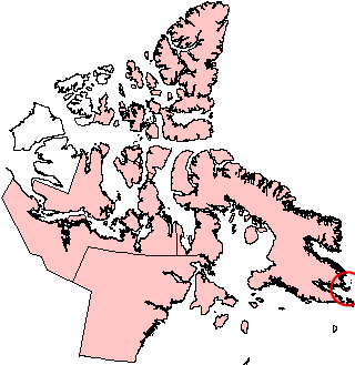
image caption = Loks Land Island, Nunavut (red circle at right edge)
image size =
locator
map_custom =
native name =
native name link = Inuktikut
nickname =
location =Northern Canada
coordinates = coord|62|26|N|64|38|W|display=inline,title
archipelago =Canadian Arctic Archipelago
total islands =
major islands =
area = convert|419|km2|sqmi|abbr=on
highest mount =
elevation =
country = Canada
country admin divisions title = Territory
country admin divisions = flag|Nunavut
country largest city =Iqaluit
country largest city population = 6,184
country leader title =
country leader name =
population = Uninhabited
population as of =
density =
ethnic groups =Inuit
additional info =Loks Land Island is part of the
Canadian arctic islands inNunavut ,Canada . It is located off the eastern tip ofBaffin Island 'sBlunt Peninsula , close to the mouth ofFrobisher Bay , at 62°26'N 64°38'W, and with an area of convert|419|km2|sqmi|abbr=on and a coastline of 206 km. The localInuktitut name for the island is "Takuligjuaq".Loks Land was the site of one of the stations in the
Distant Early Warning Line radar defence network, and had the code number BAF-4A.The island was discovered by
Martin Frobisher and is named forMichael Lok , a London financier who was one of the patrons of Frobisher's Arctic expeditions of the 1570s. Frobisher's first expedition found ore which was purported to contain gold, leading to a second and third expedition which failed to find any of the precious metal. These later speculative ventures almost bankrupted Lok.External links
* [http://www.civilization.ca/hist/frobisher/frsub04e.html Michael Lok]
* [http://www.lswilson.ca/dewline.htm#L DEW Line stations]
Wikimedia Foundation. 2010.