- Killiniq Island
Infobox Islands
name = Killiniq Island
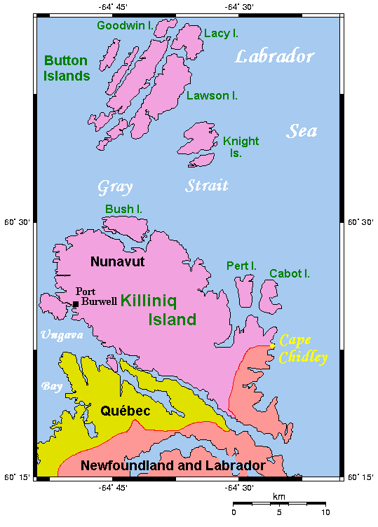
image caption = Map of Killiniq Island
image size =
locator
map_custom =
native name =
native name link = Inuktikut
nickname =
location =Northern Canada
coordinates = coord|60|22|N|64|37|W|display=inline,title
archipelago =Canadian Arctic Archipelago
total islands =
major islands =
area = convert|269|km2|sqmi|abbr=on
highest mount =
elevation =
country = Canada
country admin divisions title = Territory
country admin divisions = flag|Nunavut
country largest city =Iqaluit
country largest city population = 6,184
country leader title =
country leader name =
population = Uninhabited
population as of =
density =
ethnic groups =Inuit
additional info =Killiniq Island (English: "ice flows"cite web|url=http://www.livingdictionary.com/search/viewResults.jsp?language=en&searchString=Killiniq&languageSet=all |title=killiniq|work=Asuilaak Living Dictionary|accessdate=2007-12-22] ) is a small, remote
island in northeasternCanada . Located at the extreme northern tip ofLabrador betweenUngava Bay and theLabrador Sea , it is notable in that it contains the only land border betweenNunavut Territory and the province ofNewfoundland and Labrador , as the mainland border betweenQuebec and Newfoundland and Labrador continues through this littoral island. Most other islands off the northern coast of Quebec and Labrador belong exclusively to Nunavut.The northernmost point of Newfoundland and Labrador is
Cape Chidley on the island.A former community, also called Killiniq or Port Burwell, is found on the Nunavut side of the island, which is part of the territory's
Qikiqtaaluk Region .Some cartographic sources do not correctly show its geopolitical boundaries.
History
Although the
Inuit of Killiniq were recognized as a signatory to theJames Bay and Northern Quebec Agreement in November 1975, this did not prevent a gradual deterioration in government services and programs at Killiniq. This decline created an insecure environment and gave rise to a slow outmigration of families in search of settlements with assured access to essential services, especially medical and air transport. Between November 1975 and February 1978, a total of 50 Inuit left Killiniq in search of a more secure environment. OnFebruary 8 1978 , the 47 people that remained were notified by radio that the Federal government was sending planes to take them from the community and that Killiniq would be closed.All of the former residents are now scattered in five host communities. They arrived with housing, without income, and without many of their personal effects. Family groups were broken up and the people separated from their seasonal hunting territory. The "host communities" were neither advised nor prepared for this influx of people and there have been no follow up programs or special funds to help with their resettlement. [
Makivik Corporation , "Taqpangajuk Relocation: A Feasibility Study, Phase II", Final Report, volume ii (1987), p. i.]The town was demolished during the 1980s or 1990s. The power lines and poles were cut down and the abandoned residences bulldozed or burned. A broken down bulldozer still exists at the site however the fuel supplies that had been left have been reported to have been depleted by visitors to the site.
References
Wikimedia Foundation. 2010.