- Prince Patrick Island
-
Prince Patrick 
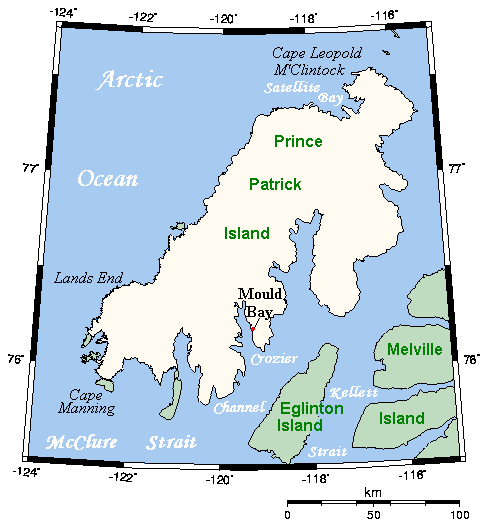
Closer look at Prince Patrick Island, showing the Mould Bay weather station
Geography Location Northern Canada Coordinates 76°45′N 119°30′W / 76.75°N 119.5°WCoordinates: 76°45′N 119°30′W / 76.75°N 119.5°W Archipelago Queen Elizabeth Islands
Canadian Arctic ArchipelagoArea 15,848 km2 (6,118.9 sq mi) Area rank 55th Highest elevation 279 m (915 ft) Highest point unnamed Country CanadaTerritory  Northwest Territories
Demographics Population Uninhabited A member of the Canadian Arctic Archipelago, Prince Patrick Island is the westernmost of the Queen Elizabeth Islands in the Northwest Territories of Canada. The area of the island is 15,848 km2 (6,119 sq mi),[1] making it the 55th largest island in the world and Canada's 14th largest island. It has historically been icebound all year, making it one of the most inaccessible parts of Canada.
Located at the entrance of the M'Clure Strait, Prince Patrick Island is uninhabited. A High Arctic Weather Station (H.A.W.S.) called Mould Bay was opened in 1948 as part of a joint Canada-U.S. military effort to support a weather station network. Regular weather observations began on May 14, 1948. It had a temporary staff of between 10 and 40 people. The station was closed in 1997 owing to budget cuts and replaced with an automated weather station at a new location on the airstrip below the station. The last manned weather observations were taken on March 31, 1997, ending the continuous weather record of 1948-1997. The buildings still stand, but as of 2007 most have deteriorated to an unrepairable state.[2] The station represented the only known long-term human settlement of the Island.
The first known sighting of the island was in 1853 by George Mecham, when it was explored by him and Francis Leopold McClintock the spring of that year.[3] Much later, it was named for Prince Arthur William Patrick, Duke of Connaught, who was Governor General 1911-16.
The island rises to only about 279 m (915 ft),[4] and the area is seismically active.
Prince Patrick Island is the setting for a work of fiction, the novel The Lost Ones (1961) by Ian Cameron (Donald G. Payne). It was filmed as the Walt Disney Pictures film The Island at the Top of the World in 1974. The novel tells of a lost colony of Vikings living in a lost valley in the island, which, thanks to the volcanoes on the island, is warm and habitable.
Contents
Climate
Climate data for Prince Patrick Island (Mould Bay) Month Jan Feb Mar Apr May Jun Jul Aug Sep Oct Nov Dec Year Record high °C (°F) −5.3
(22.5)−4.9
(23.2)−6.7
(19.9)−0.5
(31.1)5.6
(42.1)13.7
(56.7)17.5
(63.5)14.4
(57.9)7.8
(46.0)2.5
(36.5)−1.7
(28.9)−2.6
(27.3)17.5
(63.5)Average high °C (°F) −29.4
(−20.9)−30.2
(−22.4)−28.3
(−18.9)−19.8
(−3.6)−7.9
(17.8)2.5
(36.5)6.8
(44.2)3.0
(37.4)−3.9
(25.0)−14.1
(6.6)−23.1
(−9.6)−27.3
(−17.1)14.3 Daily mean °C (°F) −33.1
(−27.6)−34
(−29)−31.9
(−25.4)−23.8
(−10.8)−11
(12.2)0.2
(32.4)4.0
(39.2)0.9
(33.6)−6.4
(20.5)−17.7
(0.1)−26.7
(−16.1)−30.8
(−23.4)−17.5 Average low °C (°F) −36.8
(−34.2)−37.8
(−36.0)−35.5
(−31.9)−27.8
(−18.0)−14.1
(6.6)−2.1
(28.2)1.3
(34.3)−1.3
(29.7)−8.8
(16.2)−21.3
(−6.3)−30.3
(−22.5)−34.4
(−29.9)−20.7 Record low °C (°F) −52.2
(−62.0)−53.9
(−65.0)−50
(−58.0)−46.1
(−51.0)−28.9
(−20.0)−14.4
(6.1)−3.9
(25.0)−13.5
(7.7)−26.1
(−15.0)−37.9
(−36.2)−44.4
(−47.9)−52.8
(−63.0)−53.9
(−65.0)Precipitation mm (inches) 4.1
(0.161)4.6
(0.181)3.5
(0.138)5.7
(0.224)8.9
(0.35)8.6
(0.339)13.5
(0.531)22.5
(0.886)17.4
(0.685)11.7
(0.461)6.3
(0.248)4.4
(0.173)111.0
(4.37)Sunshine hours n/a n/a 106.6 291.1 301.3 280.2 258.3 128.7 45.7 11.9 n/a n/a n/a Source no. 1: 1971-2000 Environment Canada[5] Source no. 2: Sunshine data from 1961-1990 Environment Canada [6] References
- ^ Prince Patrick Island at the Atlas of Canada
- ^ See Mould Bay photographs for types of construction.
- ^ M'Dougall, George F. (1857). The eventful voyage of H.M. discovery ship "Resolute" to the Arctic regions, in search of Sir John Franklin and the missing crews of H.M. discovery ships "Erebus" and "Terror," 1852, 1853, 1854. London: Longman, Brown, Green, Longmans, & Roberts. http://books.google.com/books?id=Bm4SAAAAYAAJ&pg=PA452&dq=The+Eventful+Voyages+of+HMS+Resolute#v=onepage&q&f=false.
- ^ Prince Patrick Island High Point, Northwest Territories
- ^ Environment Canada—Canadian Climate Normals 1971–2000. Retrieved 17 June 2011.
- ^ Environment Canada—Canadian Climate Normals 1961–1990. Retrieved 22 June 2011.
Further reading
- Frebold, Hans. Fauna, Age and Correlation of the Jurassic Rocks of Prince Patrick Island. Ottawa: E. Cloutier, Queen's printer, 1957.
- Harrison, J. C., and T. A. Brent. Basins and fold belts of Prince Patrick Island and adjacent areas, Canadian Arctic Islands. [Ottawa]: Geological Survey of Canada, 2005. ISBN 0-660-19008-7
- Miller, F. L. Peary Caribou and Muskoxen on Prince Patrick Island, Eglinton Island, and Emerald Isle, Northwest Territories, July 1986. [Edmonton]: Canadian Wildlife Service, 1987. ISBN 0-662-15652-8
- Pissart, A. The Pingos of Prince Patrick Island (760N - 1200W). Ottawa: National Research Council of Canada, 1970.
- Tedrow, John C. F., P. F. Bruggemann, and Grant Fontain Walton. Soils of Prince Patrick Island. Research paper (Arctic Institute of North America), no. 44. Washington: Arctic Institute of North America, 1968.
External links
- Prince Patrick Island on the Canada's Arctic website.
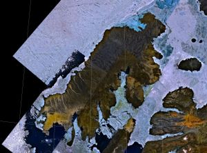 NASA landsat image of Prince Patrick Island
Queen Elizabeth Islands, Nunavut and Northwest Territories, Canada Ellesmere Island: Parry Islands (major): Devon • Melville • Bathurst • Prince Patrick • Cornwallis • Mackenzie King • Borden • Cornwall • Eglinton • Graham • Lougheed • Byam Martin • Île Vanier • Cameron • Brock • North Kent • Emerald Isle • Alexander • Massey • Little Cornwallis • Coburg • Helena • Baillie-Hamilton • Griffith • Hoved • Lowther • BuckinghamParry Islands (minor): Beechey • Berkeley • Browne • Cheyne • Cocked Hat • Crescent • Des Voeux • Dundas • Edmund Walker • Eight Bears • Ekins • Fairholme • Fitzwilliam Owen • Findlay Group • Grosvenor • Hans • Houston Stewart • Hyde Parker • Île Marc • John Barrow • Margaret • Nookap • Norman Lockyer • Patterson • Philpots • Pim • Princess Royal • Skraeling • Stupart • Table • Thor • TruroSverdrup Islands (major): Sverdrup Islands (minor): Arey Island • Baillie Island • Banks Island • Barter Island • Cross Island • Ellice Island • Garry Island • Herschel Island • Hooper Island • Jones Island • Kendall Island • Mc Clure Island • Maguire Island • Pingok Island • Prince Patrick Island • Pullen Island • Stockton IslandCategories:- Uninhabited islands of the Northwest Territories
- Islands of the Beaufort Sea
- Queen Elizabeth Islands
- Former populated places in the Inuvik Region
- Former populated places in Arctic Canada


Wikimedia Foundation. 2010.