- Meighen Island
-
Meighen Island 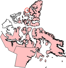
Meighen Island, NunavutGeography Location Arctic Ocean Coordinates 79°59′N 099°30′W / 79.983°N 99.5°WCoordinates: 79°59′N 099°30′W / 79.983°N 99.5°W Archipelago Sverdrup Islands[1]
Queen Elizabeth Islands
Canadian Arctic ArchipelagoArea 955 km2 (368.7 sq mi) Country CanadaProvince  Nunavut
Region Qikiqtaaluk Demographics Population Uninhabited  Closeup of Meighen Island
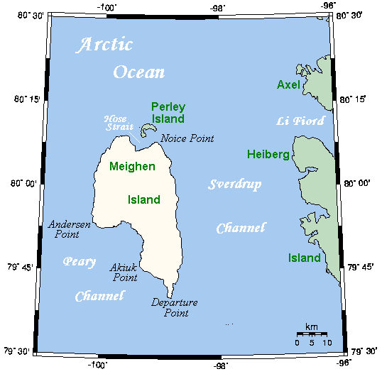
Meighen Island is an uninhabited member of the Queen Elizabeth Islands, part of the Canadian Arctic Archipelago, in the Qikiqtaaluk Region of Nunavut, Canada. Located at 79°55'N 99°30'W, it measures 955 km2 (369 sq mi) in size and is topped with an ice cap. The island is continuously icebound, and its northwestern coast faces onto the open Arctic Ocean. The first known sighting of the island was in 1916, during the Canadian Arctic Expedition by Vilhjalmur Stefansson, and later named after Arthur Meighen, Canadian prime minister. Unlike many Canadian Arctic islands, no traces of Inuit or Thule camps have been found, suggesting the island has never been occupied, and this is likely due to its extreme northern latitude.
Meighen Island has few neighbours. It is about 40 km (25 mi) west of the next nearest major island, Axel Heiberg Island. About 4 km (2.5 mi) to Meighen's north, across the Hose Strait, lies small crescent-shaped Perley Island. The Fay Islands lie between Meighen Island and Axel Heiberg Island within the Sverdrup Channel.
References
Queen Elizabeth Islands, Nunavut and Northwest Territories, Canada Ellesmere Island: Parry Islands (major): Devon • Melville • Bathurst • Prince Patrick • Cornwallis • Mackenzie King • Borden • Cornwall • Eglinton • Graham • Lougheed • Byam Martin • Île Vanier • Cameron • Brock • North Kent • Emerald Isle • Alexander • Massey • Little Cornwallis • Coburg • Helena • Baillie-Hamilton • Griffith • Hoved • Lowther • BuckinghamParry Islands (minor): Beechey • Berkeley • Browne • Cheyne • Cocked Hat • Crescent • Des Voeux • Dundas • Edmund Walker • Eight Bears • Ekins • Fairholme • Fitzwilliam Owen • Findlay Group • Grosvenor • Hans • Houston Stewart • Hyde Parker • Île Marc • John Barrow • Margaret • Nookap • Norman Lockyer • Patterson • Philpots • Pim • Princess Royal • Skraeling • Stupart • Table • Thor • TruroSverdrup Islands (major): Sverdrup Islands (minor): Fay • Gretha • Haig-Thomas • Hat • UlvingenIslands of the Qikiqtaaluk Region Adams · Akpatok · Alfred · Allen · Amherst · Arvalik · Aulitivik · Aulitiving · Baffin · Barth · Beloeil · Bergesen · Bjarnason · Bylot · Curry · Davids · Dexterity · Diana · Edgeworth · Eider · Elder · Emmerson · Fraser · Frechette · Gyrfalcon · Hamilton · Imiqqutailaqtuuq · Kaigosuiyat · Kilian · Lady Franklin · Landslip · Liddon · Lock · Low · Marvin · Nakoaiyet · Nova Zembla · Old Squaw · Ormonde · Otrick · Pandora · Payne · Peter Richards · Pisiktarfik · Plover · Prescott · Prince Leopold · Prince of Wales · Ragged · Round · Russell · Salikuit · Saneruarsuk · Scott · Sillem · Somerset · Spicer · Stephens · Trinity · Vesey Hamilton · Vivian · Ward Hunt · Wollaston · Yeoman · YoungBelcher Islands Islands of Cumberland Sound Akulagok · Anarnittuq · Aupaluktok · Aupaluktut · Beacon · Blacklead · Clear Passage · Drum · Ekallulik · Iglunga · Imigen · Ivisa · Kaigosuit · Kangigutsak · Kekertelung · Kekertelung · Kekerten · Kekertukdjuak · Kudjak · Maktaktujanak · Miliakdjuin · Moodie · Nimigen · Nunatak · Nuvujen · Opingivik · Sanigut · Saunik · Shakshukowshee · Shakshukuk · Tesseralik · Tuapait · Ugpitimik · Utsusivik · WarehamIslands of Davis Strait Akuglek · Alikdjuak · Angijak · Durban · Idjuniving · Kekertaluk · Kekertuk · Kekerturnak · Manitung · Monumental · Nedlukseak · Nudlung · Nunatsiaq · Nuvuktik · Padloping · Pilektuak · Qaqaluit · Rock · SatigsunIslands of Foxe Basin Air Force · Bird · Bray · Deer · Foley · Igloolik · Jens Munk · Koch · Neerlonakto · North Tweedsmuir · Prince Charles · Rowley · South Tweedsmuir · Tern · White · WinterIslands of Frobisher Bay Algerine · Alligator · Anchorage · Aubrey · Augustus · Bear · Beveridge · Bishop · Brigus · Brook · Bruce · Cairn · Camp · Carter · Chase · Coffin · Crimmins · Crowell · Culbertson · Daniel · Dog · Eden · Emerick · Falk · Faris · Field · Fletcher · Frobisher's Farthest · Gabriel · Gardiner · Gay · Gross · Halford · Hantzsch · Harper · Hill · Jenvey · Kudlago · Kungo · Lefferts · Leopold · Loks Land · Long · Low · Luella · Mair · Mark · Mary · McAllister · McBride · McLaren · McLean · Metela · Mitchell · Monument · Nest · Nouyarn · Ogden · Pan · Peak · Pichit · Pike · Pink Lady · Pope · Potter · Precipice · Ptarmigan · Pugh · Qarsau · Quadrifid · Redan · Resor · Sale · Scalene · Sliver · Smith · Sybil · Thompson · WhiskukunIslands of the Gulf of Boothia Islands of Hudson Bay Islands of Hudson Strait Alareak · Aulassivik · Avingasittuit Siqinirsipangat · Beacon · Big · Black Bluff · Bush · Button · Charles · Clark · Dolphin · Dorset · Edgell · Emma · Erhardt · Forder · Glasgow · Glencoe · Goodwin · Gudmusson · Hector · High Bluff · Holdridge · Ijjurittiak · Ivisaat · Juet · King · Lacy · Lavoie · Lawson · Leading · Lee · Lower Savage · MacColl · Mallik · Middle Savage · Mill · Niels · Nottingham · Nunajuak · Nuvursiit · Nuvursirpaaraaluk · Observation · Okolli · Point · Poodlatee · Rabbit · Resolution · Sakkiak · Salisbury · Sheer · Strathcona · Uugalautiit · WishartIslands of James Bay Akimiski · Bear · Big · Cape Hope · Carey · Charlton · Grey Goose · Gull · Jacob · North Twin · Paint Hills · Solomons Temple · South Twin · Spencer · Strutton · Sunday · Trodely · Twin · Walter · WestonIslands of the Labrador Sea Brevoort · Cape Chidley · Christopher Hall · Hozier · Hudson · Ilikok · Jackson · Killiniq · Knight · Leybourne · Little Hall · Muingmak · RogersQueen Elizabeth Islands Alexander · Baillie-Hamilton · Bathurst · Beechey · Berkeley • Borden · Brock · Browne · Buckingham · Byam Martin · Cameron · Cheyne · Coburg · Cocked Hat · Cornwall · Cornwallis · Crescent · Des Voeux · Devon · Dundas · Edmund Walker · Eglinton · Ekins · Ellesmere · Emerald · Exmouth · Fairholme · Findlay Group · Garrett · Graham · Griffith · Grosvenor · Hansdisputed · Helena · Houston Stewart · Hoved · Hyde Parker · John Barrow · Little Cornwallis · Lougheed · Lowther · Mackenzie King · Marc · Margaret · Massey · Melville · Nookap · Norman Lockyer · North Kent · Patterson · Philpots · Pim · Pioneer · Prince Patrick · Princess Royal · Seymour · Skraeling · Spit · Stupart · Table · Thor · Truro · VanierSverdrup Islands Amund Ringnes · Axel Heiberg · Ellef Ringnes · Fay · Gretha · Haig-Thomas · Hat · King Christian · Meighen · Stor · UlvingenSee also Islands of the Kitikmeot Region, Islands of the Kivalliq Region. Categories:- Queen Elizabeth Islands
- Islands of Qikiqtaaluk Region
- Uninhabited islands of Qikiqtaaluk Region
- Canadian Arctic Archipelago
- Sverdrup Islands
- Qikiqtaaluk Region, Nunavut geography stubs

Wikimedia Foundation. 2010.