- Jersey Bridge
-
Jersey Bridge Bridge in Cherrytree Township, Drake Well Bridge 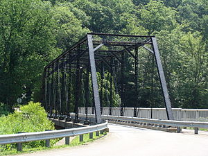
Country United States State Pennsylvania County Venango Township Cherrytree Township Road SR 1011 Crosses Oil Creek Coordinates 41°36′55″N 79°39′27″W / 41.61528°N 79.6575°W Length 42.7 m (140 ft) [1] Width 10.1 m (33 ft) [1] Builder Morse Bridge Company Design Pratt through truss bridge Material Steel Built 1882 - Added to NRHP 22 June 1988 - Reopened 27 May 1998 Governing body PennDOT NBI # 601011001014800 [1] NRHP # 88000809 [2] ADT 816 (2008)[1] MPS Highway Bridges Owned by the Commonwealth of Pennsylvania, Department of Transportation TR 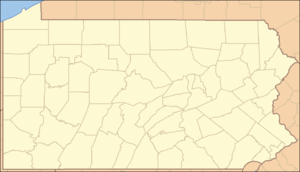
 Location of the Jersey Bridge in Pennsylvania
Wikimedia Commons: Jersey Bridge The Jersey Bridge is a one-lane, Pratt through truss bridge that spans Oil Creek in Cherrytree Township, Venango County in the U.S. state of Pennsylvania. It connects the city of Titusville to the Drake Well Museum and Oil Creek State Park. The bridge was listed on the National Register of Historic Places in 1988. It was replaced in 1998 with a modern bridge that used the superstructure of the old bridge.
Contents
History
The Jersey Bridge was constructed in 1882 by the Morse Bridge Company, the predecessor to Youngstown Bridge Company.[3] The Pennsylvania Department of Transportation (PennDOT) instituted a 10 short tons (9.1 t) weight limit for the bridge due to its detoriating condition in 1979.[4] It was listed on the National Register of Historic Places on June 22, 1988.[2] The bridge was replaced in 1997 to meet safety requirements from PennDOT, as well as to allow tour buses heading to the nearby Drake Well Museum. The replacement of the bridge, on the only route to and from museum, forced the museum to close on November 2, 1997.[4] The museum was able to reopen in April 1998 after an agreement with the Oil Creek and Titusville Railroad, which operates a train station at the museum, to transport tourists from Titusville to Drake Well.[4] The refurbished Jersey Bridge was reopened on May 27, 1998.
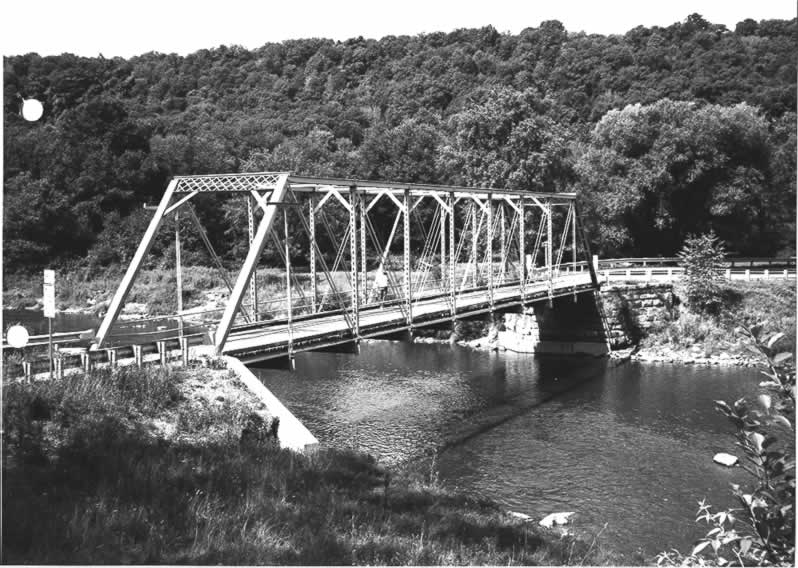
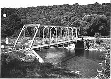 PennDOT photo of the bridge in 1982
Design
After it was rebuilt in 1998, the new Jersey Bridge utilized the old bridge's superstructure, but the actual loadbearing substructure is a modern girder bridge.[1] The superstructure remained a pin-connected, Pratt through truss bridge.[3] The bridge is still one-lane, but has a pedestrian walkway on one side of the bridge outside the superstructure.
See also
- List of bridges on the National Register of Historic Places in Pennsylvania
- National Register of Historic Places listings in Venango County, Pennsylvania
References
- ^ a b c d e Federal Highway Administration (2010). "State: PA, Place Name: Oilcreek (Township of), County: Venango, NBI Structure Number: 601011001014800". National Bridge Inventory. Nationalbridges.com (Alexander Svirsky). http://nationalbridges.com/index.php?option=com_lqm&ff645ff0638bc08405e23714b07b706e=1&task=showResults&query=8&lqm_id=537254&&format=raw&&Itemid=2. Retrieved July 5, 2011. Note: this is a formatted scrape of the 2010 official website, which can be found here for Pennsylvania: "PA10.txt". Federal Highway Administration. 2010. http://www.fhwa.dot.gov/bridge/nbi/2010/PA10.txt. Retrieved July 5, 2011.
- ^ a b "NPS Focus". National Register of Historic Places. National Park Service. http://nrhp.focus.nps.gov. Retrieved January 8, 2011.
- ^ a b Rapp, G. A.; Pennsylvania Department of Transportation (August 13, 1982). "Bridge in Cherrytree Township" (PDF). Pennsylvania Historic Resource Survey Form. Pennsylvania Historical and Museum Commission. p. 3. https://www.dot7.state.pa.us/ce_imagery/phmc_scans/H000028_01D.pdf. Retrieved July 5, 2011.
- ^ a b c Carroll, Jim (May 27, 1998). "Unique Bridge Opens in Titusville". Erie Morning News: p. 11B.
Bridges and tunnels on the National Register of Historic Places Alabama · Alaska · Arizona · Arkansas · California · Colorado · Connecticut · Delaware · Florida · Georgia · Guam · Hawaii · Idaho · Illinois · Indiana · Iowa · Kansas · Kentucky · Louisiana · Maine · Maryland · Massachusetts · Michigan · Minnesota · Mississippi · Missouri · Montana · Nebraska · Nevada · New Hampshire · New Jersey · New Mexico · New York · North Carolina · North Dakota · Ohio · Oklahoma · Oregon · Pennsylvania (covered) · Puerto Rico · Rhode Island · South Carolina · South Dakota · Tennessee · Texas · Utah · Vermont · Virginia · Washington · Washington, D.C. · West Virginia · Wisconsin · Wyoming
Categories:- Bridges completed in 1882
- Bridges on the National Register of Historic Places in Pennsylvania
- Buildings and structures in Venango County, Pennsylvania
- Transportation in Venango County, Pennsylvania
- Truss bridges
- Steel bridges
- Road bridges in Pennsylvania


Wikimedia Foundation. 2010.