- Chennai district
-
This article is about the district. For its eponymous headquarters, see Chennai.
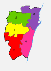 Divisions of Chennai district.
1. Egmore-Nungambakam
2. Fort Tondiarpet
3. Mambalam-Guindy
4. Mylapore-Triplicane
5. Perambur-Purasawalkkam.The Chennai District (Tamil: சென்னை மாவட்டம்) is a district in the state of Tamil nadu, in India. It is the smallest of all the districts in the state, but has the highest population.[1] The district is a city district which means that it does not have a district headquarters. Most of the city region of Chennai comes under this district. It is divided into five talukas, namely,
- Egmore-Nungambakam
- Fort Tondiarpet
- Mambalam-Guindy
- Mylapore-Triplicane
- Perambur-Purasawalkkam.
Contents
Geography
Chennai district covers an area of 178.2 km2 located on the Eastern Coastal Plains of India. It is situated on the northeastern corner of Tamil Nadu along the Coramandel coast, a region bounded by the Bay of Bengal and is surrounded inland by the districts of Tiruvallur and Kanchipuram. It lies between 12°59' and 13°9' of the northern latitude and 80°12' and 80°19' of the eastern longitude at an average altitude of 6 metres above sea level on a 'sandy shelving breaker swept' beach. Terrain slope varies from 1:5000 to 1:10,000.[2] The terrain is very flat with contours ranging from 2 m to 10 m above mean sea level with a few isolated hillocks in the southwest beyond the district limits at St. Thomas Mount, Pallavaram and Tambaram.[3] The district runs inland in a rugged semi-circular fashion and its coastline is about 25.60 km (2.5% of the total coastline of Tamil Nadu). Because of its strategic location and economic importance, it is referred to as the "Gateway of South India." The drainage system includes two rivers, namely, Cooum (flowing in the northern part) and Adyar (flowing in the southern part), a canal (the Buckingham), and a stream (the Otteri Nullah) slicing the district into several islands.
The district falls under Seismic Zone III indicating a moderate risk of earthquake. Geologically the district is divided into three regions, namely, sandy, clayey and hard-rock regions. The soil comprises clay, shale and sandstone.
Of the total land area, reserved forests cover 2.71 km2 and is concentrated in and around the Guindy National Park region, one of the few national parks in the world located within a city. The forest cover of the district is as follows:[4]
Class Area (Ha) Percentage Dense forest 151.01 1.16 Moderate dense TOF 121.16 0.93 Non-forest 12215.56 94.06 Open forest 114.24 0.88 Open TOF 153.73 1.18 Water 231.46 1.78 Total 12987.16 100 Climate
Climate data for Chennai Month Jan Feb Mar Apr May Jun Jul Aug Sep Oct Nov Dec Year Average high °C (°F) 28.4
(83.1)29.9
(85.8)31.9
(89.4)33.6
(92.5)36.4
(97.5)36.6
(97.9)34.7
(94.5)33.9
(93.0)33.5
(92.3)31.4
(88.5)29.2
(84.6)28.1
(82.6)32.3 Average low °C (°F) 20.6
(69.1)21.2
(70.2)23.1
(73.6)25.9
(78.6)27.6
(81.7)27.2
(81.0)25.9
(78.6)25.3
(77.5)25.3
(77.5)24.3
(75.7)22.8
(73.0)21.6
(70.9)24.2 Rainfall mm (inches) 20.3
(0.799)16.4
(0.646)6.7
(0.264)10.3
(0.406)44.9
(1.768)76.2
(3)106.8
(4.205)133.5
(5.256)131.6
(5.181)307
(12.09)382.5
(15.059)167.7
(6.602)1,403.9
(55.272)Avg. rainy days 1.9 1.3 .4 1.3 2.0 7.6 9.8 10.9 10.0 12.1 11.8 6.9 76 Sunshine hours 269.7 271.2 294.5 291.0 279.0 204.0 186.0 192.2 198.0 195.3 183.0 204.6 2,768.5 Source no. 1: WMO [5] Source no. 2: HKO (sun only, 1971–1990) [6] Demographics
According to the 2011 census Chennai district has a population of 4,681,087,[1] roughly equal to the nation of Norway[7] or the US state of South Carolina.[8] This gives it a ranking of 27th in India (out of a total of 640).[1] The district has a population density of 26,903 inhabitants per square kilometre (69,680 /sq mi) .[1] Its population growth rate over the decade 2001-2011 was 7.77 %.[1] Chennai has a sex ratio of 986 females for every 1000 males,[1] and a literacy rate of 90.33 %.[1]
This district is listed as the "most advanced" district in Tamil Nadu. It had a resident population of 4,681,087 as of 2011, yielding an average density of 26,903 persons per km2, excluding the huge commuter traffic from neighbouring districts. This is against a density of 24,963 persons per km2 in 2001, making it the district with the second highest density in the country.[9] The sex ratio is 1000:951. The average literacy rate is 80.14%, much higher than the national average of 64.5%. It is 100% urbanised as per Census 2011.[10] Chennai District has 13.39 per cent of the urban population in the state of Tamil Nadu. The decadal growth of population in Chennai District during 2001-2011 is 7.77 percent.
Politics
Assembly
ConstituencyPolitical
PartyElected
RepresentativeRoyapuram AIADMK D. Jayakumar Harbour AIADMK Pala. Karuppiah Dr. Radhakrishnan Nagar AIADMK P. Vetriivel Thiru. Vi. Ka Nagar AIADMK V. Neelakandan Virugampakkam DMDK B. Parthasarathy Perambur CPIM A. Soundararajan Kolathur DMK M. K. Stalin Egmore DMDK K. Nalla Thambi Anna Nagar AIADMK S. Gokula Indira Villivakkam AIADMK J. C. D. Prabhakar Thiyagaraya Nagar AIADMK V. P. Kalairajan Thousand Lights AIADMK B. Valarmathi Chepauk-Thiruvallikeni DMK J. Anbazhagan Velachery AIADMK M. K. Ashok Mylapore AIADMK R. Rajalakshmi Saidapet AIADMK G. Senthamizhan Source: Office of the CEO,Tamil Nadu.[11] Lok Sabha
ConstituencyPolitical
PartyElected
RepresentativeChennai North DMK T. K. S. Elangovan Chennai South AIADMK C. Rajendran Chennai Central DMK Dayanidhi Maran Source: Indian Elections / Election Commission of India.[12][13][14] References
- ^ a b c d e f g "District Census 2011". Census2011.co.in. 2011. http://www.census2011.co.in/district.php. Retrieved 2011-09-30.
- ^ Session-3 River and Drainage System in CMA
- ^ Chapter IX Macro Drainage System in CMA
- ^ [1]
- ^ "World Weather Information Service - Chennai". World Meteorological Organisation. http://worldweather.wmo.int/066/c00527.htm. Retrieved 2011-05-04.
- ^ "Climatological Information for Madras, India". Hong Kong Observatory. http://www.hko.gov.hk/wxinfo/climat/world/eng/asia/india/madras_e.htm. Retrieved 2011-05-04.
- ^ US Directorate of Intelligence. "Country Comparison:Population". https://www.cia.gov/library/publications/the-world-factbook/rankorder/2119rank.html. Retrieved 2011-10-01. "Norway 4,691,849 July 2011 est."
- ^ "2010 Resident Population Data". U. S. Census Bureau. http://2010.census.gov/2010census/data/apportionment-pop-text.php. Retrieved 2011-09-30. "South Carolina 4,625,364"
- ^ Suburbs record higher population growth
- ^ http://www.censusindia.gov.in/2011-prov-results/prov_data_products_tamilnadu.html
- ^ "Chennai District MLA details". Election Commission of India. http://www.elections.tn.gov.in/TNLA2011_Winner_Runner.pdf.
- ^ "Election results". Indian Elections. http://www.indian-elections.com/assembly-elections/tamil-nadu/election-result-06.html.
- ^ "Parties Statistics". Election Commission of India. http://www.eci.gov.in/StatisticalReports/ElectionStatistics.asp.
- ^ "City Constituency post-delimitation details". Election Commission of India. http://164.100.9.199/ecimaps/ECIPDF/Tamilnadu_Maps/Chennai.pdf.
External links

Thiruvallur district 
Bay of Bengal  Chennai district

Kanchipuram district Chennai district State 
Region Taluks Egmore-Nungambakkam · Fort-Tondiarpet · Mambalam-Guindy · Mylapore-Triplicane · Perambur-PurasawalkamChennai History History of Chennai, Fort St George, Madras Presidency, George Town, Chennai, Pallava, SMS Emden (1906), Treaty of Aix-la-Chapelle (1748), Siege of Madras, Battle of Madras, Carnatic Wars, Thomas Parry (Chennai merchant), Arbuthnot & Co, Madras State,Geography Geography of Chennai, Chennai District, Coromandel Coast, Cooum River, Adyar River, Pallikaranai Marsh, Chembarambakkam Lake, Ennore creek, Birding in Chennai, Otteri Nullah, Kosasthalaiyar River, Buckingham Canal, Chetput Lake
Architecture LIC Building, Broken Bridge, Chennai architecture, Madras High Court, Valluvar Kottam, Vivekanandar Illam, Seven Pagodas of Mahabalipuram, Government Museum, Ravishwarar, Victoria Public Hall, Madras War Cemetery, Rajiv Gandhi Memorial, Lighthouse, Ripon Building, Napier Bridge, Chennai Central Prison, Puzhal Central PrisonPlaces of worship Kapaleeswarar Temple, Parthasarathy Temple, Marundeeswarar Temple, Ashtalakshmi Kovil, Santhome Basilica, Madhya Kailash, Church of Our Lady of Light, Kalikambal Temple, Saint Patrick's Cathedral, St. George's Cathedral, St. Mary's Church (Fort St. George), Varasiddhi Vinayaka temple, Armenian Church,Corporations Chennai Corporation, North Chennai Corporation, South Chennai CorporationLocalities North Chennai West Chennai Sriperumbudur, Tiruvallur, Arakkonam, Valasaravakkam, Alwarthirunagar, Virugambakkam, Aminjikarai, Anna Nagar, Anna Nagar West, Mogappair, Arumbakkam, Ashok Nagar, Choolaimedu, KK Nagar, Koyambedu, Manapakkam, Nandambakkam, Poonamallee, Porur, Shenoy Nagar, Thirumangalam, Vadapalani, West MambalamCentral Chennai T Nagar, Parry's Corner, Saidapet, Mylapore, Chepauk, Chetput, Egmore, George Town, Kilpauk, Mambalam, Nandanam, Nungambakkam, Palavakkam, Panagal Park, Park Town, Chennai, Parry's Corner, Pondy Bazaar, Royapettah, Santhome, Teynampet, Triplicane, Trustpuram, Kodambakkam,South Chennai Adyar, Besant Nagar, Guindy, Thuraipakkam, Velachery, Adambakkam, Chitlapakkam, Chromepet, Foreshore Estate, Greenways Road, Guindy Thiru Vi Ka Estate, Injambakkam, Karapakkam, Kotturpuram, Madipakkam, Mandavelli, Meenambakkam, Nanganallur, Neelankarai, Pazhavanthangal, Pammal, Perungalathur, Perungudi, Puzhuthivakkam, Jafferkhanpet, Sholinganallur, St. Thomas Mount, Tambaram, Taramani, Thiruvanmiyur, Tirusulam, Pallavaram, AlandurEducation Education in Chennai, Schools in Chennai, Connemara Public Library, Anna Centenary Library
Universities Anna University, Tamil Nadu Veterinary and Animal Sciences University, University of Madras, Madras Christian College, Presidency College, Pachaiyappa's College, Institute of Mathematical Sciences, Chennai Mathematical Institute, Indian Maritime University, Tamil Nadu Dr. M.G.R. Medical University, Tamil Nadu Dr. Ambedkar Law UniversityEngineering colleges Medical colleges Hospitals Government General Hospital, Apollo Hospitals, Adyar Cancer Institute, Regional Institute of Ophthalmology and Government Ophthalmic Hospital, Sir Ivan Stedeford Hospital, Sankara Nethralaya, Madras Medical Mission, Frontier Lifeline & K.M.Cherian Heart Foundation, MIOT Hospital, Chettinad Health CityIndustry Automobile industry in Chennai, EMS Industry in Chennai, Heavy Vehicles Factory, Integral Coach Factory, Irevna, EID Parry, Anabond, Accel Transmatic Limited, Anantara Solutions, Murugappa Group, Madras Rubber Factory, Ashok Leyland, Royal Enfield, Sify, TI Cycles of India, TVS Motors, Laser SoftScience & Technology Central Leather Research Institute, Birla Planetarium, Regional Meteorological Centre, National Institute of Ocean TechnologyInfrastructure Transportation Transport in Chennai, Chennai Metro, Chennai Monorail, Chennai BRTS, Chennai RBTW, Chennai Suburban Railway, Chennai MRTS, Chennai Elevated Expressways, Chennai HSCTC, Chennai Bypass, Inner Ring Road, Outer Ring Road, Chennai Port - Maduravoyal Expressway, East Coast Elevated ExpresswayUrban public transits Chennai International Airport, Chennai Port, Ennore Port, Kattupalli Shipyard, Chennai Central Terminus, Chennai Central MMC Terminus, Chennai Egmore Terminus, Chennai Beach Terminus, Royapuram Railway Station, Tambaram Railway Station, Chennai Mofussil Bus Terminus, Chennai Contract Carriage Bus Terminus, Metropolitan Transport CorporationMajor roads Grade separators Kathipara Junction, Koyambedu Junction, Padi Junction, Maduravoyal Junction, Madhya Kailash JunctionFlyovers High-technology business districts IT Corridor, Automotive Corridor, Chennai ITIR, Electronics Corridor, SEZ Corridor, Entertainment Corridor, Mahindra World City, DLF IT Park, SIPCOT IT Park, Tidel Park, International Tech Park, Olympia Tech Park, List of tech parks in ChennaiTrade promotion Sports Chennai Open, Chennai Veerans, Jawaharlal Nehru Stadium, M. A. Chidambaram Stadium, SDAT Tennis Stadium, Sholavaram, Chennai Super Kings, Chennai Superstars, Madras Boat Club, Madras Motor Sports Club, Irungattukottai Race Track, Cosmopolitan Club, Guindy Race Course, Gymkhana Club, Sport in Chennai, Tamil Nadu Cricket Association, Velachery Aquatic Complex, Chennai Sepak Takraw LeagueBeaches & beachways Elliot's Beach, Marina Beach, East Coast Road, Golden Beach, Covelong, Thiruvanmiyur Beach, Adyar Beach, Pebble Beach, Chennai, Mamallapuram Beach, Palavakkam BeachMalls & multiplexes Spencer Plaza, Sathyam Cinemas, Chennai Citi Centre, Mayajaal Multiplex, Abirami Mall, Ampa Mall, Chennai Central Mall, Express Avenue, Coromandal Plaza, Marina Grand, AGS multiplexParks Theme parks MGM Dizzee World, Queens Land, VGP Universal Kingdom, Dash N Splash, Kishkinta, Mayajaal Beach ResortCulture Kollywood, Chennai Sangamam, Theosophical Society Adyar, Saarang, Techofes, Gaana, KM Music Conservatory, Kalakshetra, Madras Music Academy, Cholamandal Artists' Village, Moksha (Indian band), Tamil cuisine, LBG, DakshinaChitra, Chennai Book Fair,Other topics
Categories:

Wikimedia Foundation. 2010.