- Tirunelveli district
-
This article is about the district. For its eponymous headquarters, see Tirunelveli.
Tirunelveli District Nellai — district — Coordinates 8°43′55″N 77°42′01″E / 8.73194°N 77.70028°ECoordinates: 8°43′55″N 77°42′01″E / 8.73194°N 77.70028°E Country India State Tamil Nadu District(s) Tirunelveli Subdistrict(s) Tirunelveli, Palayamkottai, Sankarankovil, Ambasamudram, Nanguneri, kadayanallur Radhapuram, Tenkasi, Shenkottai, Alangulam, Veerakeralampudur, Sivagiri District formed on September 01, 1790 Headquarters Tirunelveli Largest city Tirunelveli Collector & District Magistrate Dr. R. Selvaraj, IAS Legislature (seats) elected (11) Population
• Density
3,072,880[1] (2011[update])
• 410.5 /km2 (1,063 /sq mi)
Sex ratio M-49%/F-51% ♂/♀ Literacy
• Male
• Female68.44%%
• 75.94%%
• 61.12%%Official languages Tamil Time zone IST (UTC+05:30) Area
• Coastline
6,823 square kilometres (2,634 sq mi)
• 35 kilometres (22 mi)
Climate
• Precipitation
Temperature
• Summer
• Winter
• 814.8 mm (32.08 in)
• 37 °C (99 °F)
• 22 °C (72 °F)Central location: 09°04′N 77°30′E / 9.067°N 77.5°E Website Official website of District Collectorate, Tirunelveli Tirunelveli District (Tamil: திருநெல்வேலி மாவட்டம்) is a district of Tamil Nadu state in southern India. The city of Tirunelveli is the district headquarters. A unique feature of this district is that it encompasses all five geographical traditions of Tamil Literature; kurinji (mountains), mullai (forest), marudham (paddy fields), neithal (coastal) and palai (desert). Tirunelveli District was formed on September 1, 1790[2][3] by the East India Company (on behalf of the British government), and comprised the present Tirunelveli and Thoothukudi districts and parts of Virudhunagar and Ramanathapuram districts. It is the second-largest district (as of October 2008), after Villupuram district.
Contents
History
 Nellaippar Temple
The founding date of Tirunelveli District is commemorated as Tirunelveli Day. The British East India Company named it Tinnevelly district; its headquarters was first located in Palayamkottai (an adjacent city), where it had its military headquarters during its operations against the Palayakars. There are three reasons attributed for naming the district Tirunelveli. The primary reason is after the largest city of the district; another reason is that it was been called Tirunelveli Seemai under the Nayaks and Nawabs. Finally, it served as the southern capital during the Pandyan Empire. Both Tirunelveli and Palayamkottai grew as twin cities in the district.
In the early 20th century, parts of Tirunelveli district was separated into Ramanathapuram and Virudhunagar districts. In 1986, Tirunelveli district was further split into two districts for administrative purposes: Chidambaranar (present-day Thoothukudi) and Nellai-Kattabomman (later Tirunelveli-Kattabomman and present-day Tirunelveli) districts.
Geography and climate
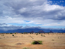 The Agasthiyamalai hills cut off Tirunelveli from the southwest monsoon, creating a rainshadow region
The district is located in the southern part of Tamil Nadu. It is surrounded by Virudhunagar District in the north, the Western Ghats in the west, Kanyakumari District in the south and Thoothukudi District in the east. The district covers an area of 6,823 km2. It lies between 8°05’ and 9°30’ north latitude and 77°05’ and 78°25’ east longitude. The district has diverse geographical and physical features. It has mountains (a stretch of the Western Ghats and lowland plains. It has a perennial river (the Tamirabarani) and small seasonal rivers. The district has many scenic waterfalls. Its physical features include sandy soil and fertile alluvium, a variety of flora, fauna and protected wildlife. The district also has inland and mountainous forests.
Tirunelveli has a unique climate, and has rainfall in all seasons (953.1 mm in 2005-2006). The district benefits from both the northeast and southwest monsoons. Most precipitation came from the northeast monsoon (548.7 mm) followed by the southwest monsoon (147.8 mm) and summer rains (184.2 mm). The district is irrigated by several rivers originating in the Western Ghats such as the Pachaiyar River, which flows into the Tambaraparani River. The Tambaraparani and Manimuthar Rivers have many dams, with reservoirs providing water for irrigation and power generation. The Tamiraparani River provides consistent irrigation to a large agricultural area.[4] The Chittar River also originates in this district. The Courtallam and Manimuthar waterfalls are the two major falls in the district.
Demographics
According to the 2011 census Tirunelveli district has a population of 3,072,880,[5] roughly equal to the nation of Oman[6] or the US state of Iowa.[7] This gives it a ranking of 116th in India (out of a total of 640).[5] The district has a population density of 458 inhabitants per square kilometre (1,190 /sq mi) .[5] Its population growth rate over the decade 2001-2011 was 13.66 %.[5] Tirunelveli has a sex ratio of 1024 females for every 1000 males,[5] and a literacy rate of 82.92 %.[5]
The population at the 2001 census was 2,723,988. Of that population, 48.03% was urban with a population density of 410.5 people per square kilometer.[8] Tamil was the main language spoken. Hindus formed the majority religious group of the population (79.76%), followed by Christians (10.89%), Muslims (9.26%) and other religions (0.09%).[9]
Infrastructure
The district is well-connected by a network of roads and railways. Tirunelveli city serves as the main junction. It has no airports; the nearest airports are at Tuticorin (40 km away), Madurai (150 km) and Thiruvananthapuram. The district has a total of 27 Railway stations. Given below are tables listing the length of roads and railways in the district.[10]
Roads National highways State highways Corporation and Municipalities Roads Panchayat Union and Panchayat Road Town Panchayat and Townships Road Others (forest roads) Length (km.) 174.824 442.839 1,001.54 1,254.10 and 1,658.35 840.399 114.450 Railways Route length (km) Track length (km) Broad gauge 77.000 95.448 Meter gauge 125.000 134.430 Canals, wells, tanks and reservoirs are the sources of irrigation in the district. As of 2005–2006, the district had a total of 151 canals with a length of 499 km, 85,701 irrigation wells, 640 tube wells, 8 reservoirs and 2,212 tanks. The district also has 21,776 wells used for domestic purposes. Electricity is provided by the Tamil Nadu Electricity Board (TNEB).[10] The district has hydroelectric power plants and windmills, with an installed capacity of 1,089.675 MW; it is one of the major producers of wind energy in the state. The Koodankulam Nuclear Power Plant project is being undertaken (with Russian aid) at the village of Koodankulam.
Education and social development
Tirunelveli is known for its educational institutions, many of which are located at Palayamkottai (east of Tirunelveli). For this reason, Palayamkottai is known as the "Oxford of South India". The district has a literacy rate of 76.97%, which is above the state average. As of 2005–2006, the district had a total of 2,494 schools. It has one university (the Manonmaniam Sundaranar University). There are also four government colleges, eleven government-sponsored colleges and seven private colleges; in addition, there is a computer-education centre (Nellai Information Technology Institute, or NITI) in Palayamkottai.[10]
Tirunelveli has a poverty rate of 31.8%, which is higher than the state and national averages.[10] The district has a good record in religious harmony, but a poor one in caste discrimination and caste-based violence.[11] The 1999 drowning of 17 striking Dalit tea-plantation workers in the river Thamiraparani is one such incident which was condemned by Human Rights Watch observers.[12][13]
Tirunelveli has the following educational institutions:
- Universities: 2
- Arts and science colleges: 25
- Medical College: 1
- Siddha medical college: 1
- Engineering colleges: 20
- Law school: 1
- Pre-kindergartens: 241
- Primary schools: 1,501
- Middle schools: 431
- High schools: 114
- Higher secondary schools: 185
- Teacher-training institutes: 28
Manonmaniam Sundaranar University
Manonmaniam Sundaranar University (MSU) was established in 1990. Named after poet Sundaram Pillai, the university has a network of 102 affiliated colleges. Many of these colleges have contributed to higher education for decades; five colleges are more than 100 years old. The University campus is located at Abishekapatti, nine km from Tirunelveli town. Advanced studies are offered in a number of departments, and postgraduate programmes in chemistry, communications, computer science, English, environmental studies, history, mathematics, physics, sociology and statistics are offered.
The university has introduced compulsory core courses in Indian studies. The curriculum includes "History of Freedom Movement in India", "Gandhian Thought", "Ecology, Environment and Pollution Studies", "Status of Women in India", "History of Science", "Indian Economy Since Independence", "Rural India", "Consumer Protection and Social Responsibility in Business" and "Secularism". It has set up a centre for environmental studies at Alwarkurichi in collaboration with a corporation, Amalgamations. Eco-friendly ventures in aquaculture and fishing are encouraged. The centre has developed an organic manure, "Mano compost".
Collegiate education
In 1878, there were two colleges in the district: the Madurai Diraviam Thayumanavar Hindu College and St. John’s College. The first college for women (and third college of the district), Sarah Tucker College, began in 1895. The fourth and fifth colleges (St. Xavier’s and St. Ignatius Colleges of Education) were established in 1950 and 1957, respectively. In 1963-64 two more colleges, the Paramakalyani and Parasakthi Colleges, were added. The Ambai Arts and Thiruvalluvar Colleges (1969), Muthuramalinga Thevar College and Government Arts College for Women (1970), and the Sadaktathullah Appa and T.D.M.N.S. Colleges (1971) were established in the district. Except for Government Arts College for Women, all the other schools are private colleges run by educational trusts. There are three self-financing colleges: Saratha College for Women (1986), Sattanathakarayalar College (1994–95) and Jayaraj Annabakkiam College (1997–98).
Of the 17 arts colleges in the district eight are coeducational institutions, five are for girls and four for boys. The colleges in Tirunelveli district were originally affiliated with the University of Madras. Upon the creation of Madurai Kamaraj University in 1966, they were affiliated with MKU from 1966–1990. In 1990, their affiliation transferred to Manonmaniam Sundaranar University. The university has granted autonomous status to St. Xavier’s College in Palayamkotti and Sri Parasakthi College for Women in Courtallam. The Regional Directorate of the Collegiate Education in the district was formed on 10 September 1979 to regulate colleges in Tirunelveli, Thoothukudi and Kanyakumari districts.
School districts
In 1986, the Revenue District of Tirunelveli was divided into Tirunelveli and Thoothukkudi districts. A new post, District Educational Officer at Tenkasi, was created. The names of posts of District Educational Officer, Tirunelveli Central was changed to District Education Officer, Tirunelveli; the District Educational Officer, Tirunelveli South was redesignated District Educational Officer, Cheranmahadevi. The three District Education Officers serve under the Chief Education Officer.
Education officials Jurisdiction District Educational Officer, Tirunelveli Taluks of Tirunelveli, Palayamkottai and Sankarankoil District Educational Officer, Cheranmahdevi Taluks of Ambasamudram, Nanguneri and Radhapuram District Educational Officer, Tenkasi Taluks of Tenkasi, Shencottai, Alangulam, VK Pudur and Sivagiri District Adult Education Officer Entire district District Elementary Educational Officer Entire Tirunelveli district (primary and upper-primary schools) Assistant Elementary Educational Officers (21) One for each of the 19 panchayat unions and two for urban areas Additional Assistant Elementary Educational Officers (21) One for each of the 19 panchayat unions and two for urban areas Legal education
In Tirunelveli district, a [(GOVERNMENT LAW COLLEGE)] was established to meet the requirements of the people of the southern most part of Tamil Nadu in the year 1996 and was opened on 14 October 1996 with 80 students for the three-year law course affiliated to Manonmaniam Sundaranar University as the Fifth Government Law College in the State . A five-year B.L course is also offered from the Academic Year 2000-01.From the Academis Year 1997-98 the college is affiliated to the Tamil Nadu Dr. Ambedkar Law University, Chennai. At first, classes were held at the Ponnusamy Pillai Bungalow on Tiruchendur Road in Palayamcottai before its new building was constructed. The College has started functioning from October 2000 in its own new building in an area of 15 acres adjacent to District Court Buildings on the Tiruchendur High Road.
As directed by the Bar Council of India Semester System has been introduced for both (3 yrs and 5 yrs) Law Courses from the Academic Year 2002-03.The year 2007 set another milestone in the history of this college when M.L Degree in Constitutional Law and Human Rights was started.
Medical education
The Tirunelveli Medical College and its teaching hospital are located on about 350 acres of land at High Grounds, Palayamcottai. It was begun in 1965 and affiliated with the University of Madras, with 75 students for the academic year 1965-66. These students took their first-year courses at local arts and science colleges. In July 1966, the first group of second-year MBBS students attended the classes in the newly-constructed Anatomy Block. Other departments (such as pharmacology, pathology, microbiology and social and preventive medicine) began in subsequent years and the district-headquarters hospital was converted to Tirunelveli Medical College Hospital. The college was affiliated with Madurai Kamaraj University after its inception in 1967. Since 1988, upon the formation of Dr. M.G.R. Educational and Research Institute it has been affiliated with that university. The college was recognised by the Medical Council of India, New Delhi in 1978. The number of seats for the MBBS course was increased from 75 to 100 in 1980, and that year the state government also authorised postgraduate courses. The college celebrated its Silver Jubilee in 1990.
The following postgraduate degree courses are offered:
- M.D. General Medicine: 2
- M.D. Pathology: 1
- M.D. Micobiology: 1
- M.D. Orthopedics: 2
- M.D. Forensic Medicine:1
- M.S. General Surgery: 2
- D.G.O. Obstetrics and Gynecology: 4
The Government Siddha Medical College was establisheded at Palayamkottai on 30 November 1964. This was an affiliated College of the University of Madras until March 1966; from then until 1988 it was an affiliate of Madurai Kamaraj University, and since March 1989 of Dr. MGR Medical University.
Technical education
Technical education in the district dates to 1844, when Mrs. Caldwell (wife of Bishop Robert Caldwell) began a school to teach girls lace-making at Idyangudi. The government of Tamil Nadu set up a State Board of Technical Education and Training and a separate Directorate of Technical Education, effective 1 October 1957. Since then, the Directorate of Technical Education has assumed the administration of both engineering colleges and polytechnics since then.
The Government College of Engineering was established in October 1981 to fulfill the needs of people in the southern region. At first the college met in a bungalow near Tirunelveli Medical College, since new buildings were under construction. In 1984, the college moved into new buildings on its 25-hectare (62-acre) campus. It is currently located about 8 km from Tirunelveli Junction on the Tirunelveli-Trivandrum Highway. From its inception, the College admitted students in three undergraduate departments: civil, electronics and communication and mechanical engineering; electrical and electronics engineering was introduced during 1986-87, and computer science and engineering was added in 1989-90. A postgraduate course in computer science and engineering was introduced in 1994-95.
Economic profile
Tirunelveli has been an agricultural area throughout its history. The district is a major producer of rice, coconuts, bananas, spices and forest-based products. The district's livestock and poultry populations are as follows:[10]
Cattle Buffalo Sheep Goats Pigs Horses and Ponies Donkeys Rabbits Total livestock Total poultry 418,694 78,777 487,273 390,570 12,752 245 961 2401 67,877 1,218,583 Since it is a coastal district, Tirunelveli is also involved in fishery development and production. For the period 2005–2006 the total inland fish catch was 1,874 tonnes, and the total marine fish catch was 7,014 tonnes.[10] The district is also rich in minerals, with a total of 407 mines and quarries. Limestone, granite and garnet sand are some of the minerals mined or produced in the district. Major industries include textile, food and forestry products. A Special Economic Zone (SEZ) was introduced at Nanguneri in 2001. A pharma park and windmill spare-parts and television-manufacturing factories have been planned in this SEZ. The Tamil Nadu Industrial Development Corporation (TIDCO) has planned a Rs 700-crore high-tech industrial park in Nanguneri in association with INFAC Group and Axes Technologies Inc of the US.[14][15] The state government is planning light manufacturing, design and assembly facilities, modern infrastructure facilities and amenities in this SEZ to attract a workforce from around the world.
Karivalamvandanallur
Karivalamvandanallur is a developing village in the district, located on the Tirunelveli-Sankarankoil-Rajapalayam state highway, 10 km from Sankarankovil. It is a junction for the surrounding villages.
Thisayanvilai
A town in southeast Tirunelveli, Thisayanvilai sprang up from the shadows of Idaiyankudi and became a centre for business, education and health care. The town flourished under the guidance of a philanthropist, M. L. Asirwatham. He was the first mayor, until his death in 1973. A desert is referenced in the Tamil Nadu Gazette as "ML". The town is located in an arid area, surrounded by sandy deserts; Asirwatham pioneered the village into an agricultural town. He established roads, making the town accessible from Udangudi, Sathankulam, Valliyoor, Uvari and Nanguneri, constructed irrigation tanks, wells, water tanks and pipelines. A bus terminal and electric supply followed; Asirwatham laid the foundation for schools, hospitals and merchants. A market (santhai) held every Friday made the town more popular, and a business centre was established. Thisyanvilai is now (as of 2011) a market town, with many shops, five banks and a sand-mining industry. The educational system consists of about seven higher-secondary schools, several high-, middle, primary and industrial schools and a college. An engineering college is awaiting affiliation (as of 2011). There are several hospitals, which provide health care to the neighbouring villages. The town is connected to Chennai by private and government bus-transport operators.
The town encompasses all communities in Tirunelveli district, but the majority are Nadars. Its residents adhere to the Hindu, Christian and Muslim faiths. Several temples, three churches and two mosques dot the town. There is a Post and Telegraph office with post office substations, police and fire stations, tehsil and revenue offices, petrol stations and a public library.
Singampatti
Singampatti is now a small village which had once been a kingdom covering 340 square kilometres (130 sq mi) of land and had 32 rulers since 1100 AD. This independent kingdom-principality was transformed during the 1530s into a Palaiyakkarar territory by the Nayaks and again converted to a zamindari by the British in 1802. An earlier zamin had supported the Travancore ruler Marthanda Varma in the Ettuveetil Pillai rebellion. The Singampatti Zamin palace accommodates guests. It resembles a large house, with a 200-year-old museum housing a rare antiques collection.[16]
Sivasailam
Sivasailam is a temple named for Sivasailappar and Parvathi, which is located on the Karunaiyar River a few kilometers from Alwarkurichi (which is rich in natural resources).
Surandai
Surandai is situated between Alangulam and Puliangudi. It has five schools and one college, and is one of the fastest-growing cities in the district. Surandai serves as a trade centre for several nearby villages.
Offices in Surandai are:
- Fire service
- Post office
- Sub-registrar's office
- Banks
- Indian Overseas Bank
- Pandian Grama Bank
- Primary Agricultural
- District Central Cooperative Bank
- Kooturavu Pantag Salai (cooperative society)
- State bank of India
- Grama Vidiyal Micro Finance Ltd
- Tamil Nadu Mercantile Bank Ltd
- Federal Bank
Deivacheyalpuram
Deivacheyalpuram is a small village 21 km from Tirunelveli, en route to Thoothukudi. The Rajarajeswari and Ramar temples are located there, along with a 75-foot (23 m) statue of Lord Anjaneya (built at the temple, in the hope of world peace). Poojas are performed in the temples daily, with special poojas performed every Friday and during festivals. Daily during every full moon, the temples provide annadanam (free food to the poor).
Tenkasi
Tenkasi is known as the "Varanasi) of the south". The 400-year-old temple flagpole is noted for its sculptured beauty. It is the nearest town to Courtrallam (5 km away) and its waterfalls.
===Puliangudi===("Lemon city") Puliangudi (Tamil: புளியங்குடி) is located on the Tenkasi–Thirumangalam National Highway. It is between Tenkasi and Rajapalayam (about 30 km south of Tenkasi and 40 km north of Rajapalayam). The town is in the foothills of the Western Ghats and has a gentle slope from west to east. It covers an area of 55.166 square kilometres (21.300 sq mi), and the 2001 population was 60,142. The Puliangudi municipal area includes four villages: Mela Puliangudi, Puliangudi, Chinthamani and Thirumalai Naicken Pudukudi. It has a dry climate, except during the monsoons. Puliangudi is known as the "Lemon City" because of the variety of lemons (the main agricultural product) cultivated in the area.
Puliangudi has 18 higher secondary schools; students come to study from the nearby municipalities of Sankarankoil, Kadayanallur and Vasudevanallur. Some schools in Puliangudi are:
- Government Boys Hr Secondary School
- Government Girls Hr Secondary School
- HNUC Hr Sec School-T.N.Puthukudi
- Sri Kanna Matriculation Hr Secondary School
- Seventh Day Adventist Matriculation Hr Secondary School
- Suyambulingam Hr Secondary School
- Seeniammal Hr Secondary School
- R C High School
- Selvan Nursery and Primary School
- Arun Nursery and Primary School
- Agasthiar Nursery and Primary School
- Quid-e-Millath Hr Secondary School
- Senaithalaivar Hr Secondary School
- Mohidheen Andavar School
- T.D.T.A. Middle School
- A.V.S. High School
- New Crescent Matriculation School (CBSE)
- Kanna Girls Hr Secondary School
- HNUC High School, Chinthamani
- Packiathai Middle School
Engineering and technology institutions:
- S.V.Engineering College near Puliangudi
- Gomathiammal Polytechnic and an industrial training institute at Malayadikuruchi, 5 km from Puliangudi
Manapad
Holy Cross Church at Manapad was built in 1581. Thousands of worshipers congregate during the festival season, from 1 to 14 September. This church is also associated with St. Francis Xavier.
Tiger reserve
The 900 square kilometres (350 sq mi) Kalakkad Mundanthurai Tiger Reserve was established in 1962. The reserve, at 8°39′N 77°23′E / 8.65°N 77.383°E, is about 45 km west of Tirunelveli and is known as KMTS to forest and tiger researchers. Kalakkad is the nearest town.
Sankarankoil
The temple at Sankarankoil depicts Hari and Hara as one God. There is a deity named Sankara Narayanan, which is half Lord Shiva and half Lord Vishnu. There is another deity, named Avodai ambal or Gomathi Ambal, after whom the temple is named; it was built by Ukrama Pandiyan in 900 AD. Sacred sand is available, which is believed curative by some. June is marked by the Adi Thabasu festival.nearest village in alagunatchiyapuram
Madathupatti
It is a small village having more than 1000 families. It is situated in the middle of the Thirunelveli District having near by places like Panavadalichathiram, Ayalpatti, Arachipatti, Achempatti and Vellapaneri. The total village depand upon agriculture.This village gives to the nation so many eminent personalities and celebiratees. One of them is Mr. Thomas K Chelladurai,(Additional Superintendent of Prisons, Rtd) who served the nation in various dignified posts in Prison Department and played vital role in reforming the minds of the prisoners inside the prison and he is remembered for his oratary speech in English, presence of mind and IQ. The next one was Ramar Thevar,the only homeopathy medical practitioner, he sacrified his profession for the sake of his native people.
Vidivelli Achiramam
Vidivelli Achirmam is a C.S.I. church in the remote historic village of Sayamalai Valasai, nearly 20 km from Sankarankoil. It is the foremost Christian church in the area. It was organised and built in 1938 by two British women missionaries, named Frost and Joy Ammaiyar. P. Raja Thalaivar served as a catechist in the church and headmaster of nearby T.D.T.A. schools. P. Immanuel Santhosham (headmaster of Scafter Higher Secondary School, Tirunelveli) is also a dedicated administrator.
Tirunelveli
The Nellaiappar Temple, a well-known temple in Tamil Nadu, is located at Tirunelveli. The temple is rooted in tradition and history, and known for its musical pillars and other sculpted figures.[17] The nearest airport is Tuticorin Airport (TCR) at Vagaikulam, a 30-minute drive (32 km) from Tirunelveli.
Vallioor
Vallioor is a developing panchayati raj union in Radhapuram taluk. It is located along National Highway 7 between Tirunelveli and Nagarkoil. Vallioor was named for the goddess Valli, consort of Lord Murugan. Attractions include the Murugan Temple, the Valliyoor Kulam, the Western Ghats, kalyanamandapams (marriage halls), churches and ancient, architecturally-important temples. Also featured are international-standard schools, fire stations and a transport system, which includes a bus station.
The United Volunteer Service Society's (UVSS) New Life Home for Aged Destitutes opened seven km from Vallioor, on the road to Eruvadi. This initiative is from like-minded people; it does not involve a religious group, the government or a particular community. The Shelton garment industry, employing about 1000 people, is a major employer in Valliyur; shirts and trousers manufactured here are marketed throughout India and in Dubai.
Nanguneri
The temple town of Nanguneri, located 31 km south of Tirunelveli, is known for its Vishnu temple whose presiding deity is Thotathri Nathan. The temple is run by the Vanamamalai matha and houses the well-known Ennai Kinaru (oil well). It is one of the divya sheathram, according to Vaishnava tradition.
Perumpathu
Perumpathu is a village in Nanguneri taluk. It is located along the Tirunelveli-Nagarkoil National Highway (NH-7) and the Eruvadi road, 1.5 km in south of Nanguneri. With a sizable Nadar population, Perumpathu is known for its Narayanaswamy Temple and CSI church.
Parappadi
The village of Parappadi (Tamil: வந்தாரை வாழ வைக்கும் பரப்பாடி) is 11 km east of Nanguneri and has a population of about 7,000. Holy Trinity Church is its Christian church, which has a healing service on the first Saturday of each month and celebrates its anniversary in conjunction with a Tamil Hindu festival at the Mutharamman Kovil (temple). The village has one TDTA middle school and one state-run secondary school. Most of the population are well-educated professionals, from a variety of castes which live in harmony; 50 percent are teachers.
Veeravanallur
The village of Veeravanallur had a population of 19,681 in the 2001 census. It has an electric-power substation, Gomathi Mills and the Power weaving mill. Surrounding villages are Harikesanallur, Kiriyammalpuram, Manabaranallur, a Nainar colony, a Thambran colony, Retiyarpuram, Malayangulam, Vellangulli and Puthukudi. The village has a bharathiyar state-run school and a Roman Catholic church.
Pappankulam
This village, 15 km in east of Nanguneri, is known for its Mutharamman Temple.
Maruthur
This village, located 12 km from Palayamkottai, has tourism potential. Its stone dam, known as anaikattu, was repaired by the British in 1872. The dam, across the Thamirabarani River, is 20–35 feet high and 2.5 km long. It was constructed in a concave shape across the river to facilitate the flow of water. The dam divides the river into a maruthur melakal (western channel) and a maruthur kelakal (eastern channel). Walking on the stone wall and seeing the water flow on both sides is a popular adventure.
Venkatachalapuram
This small village has a population of more than 1000 families, and is near I.T. Park, the Coca-Cola Company and SIPCOT (State Industries Promotion Corporation of Tamil Nadu). The agricultural village has a good water supply.
R.C.Nandhankulam
This village, one of the smallest in the district, has a population of about 70 families. The letters "R.C." in the name stand for "Roman Catholic"; the Church of St. Peter celebrates a 10-day festival from May 13–23.
Dohnavur is a village near Nanguneri. German-born missionary C. T. E. Rhenius purchased land and constructed CSI Christ Church with the help of "Count Dohna" (a psudonym used by Queen Christina of Sweden), naming the village “Dohnavur”. Rev. Thomas Walker built Walker Higher Secondary School in Dohnavur and missionary Amy Carmichael constructed Parama Sugasalai Hospital and an orphanage. The village is surrounded by ponds; its residents are primarily farmers, building contractors and teachers.
Aazhigudi
Main article: AazhigudiCheranmadevi
Main article: CheranmadeviGangaikondan
Main article: GangaikondanAnimal husbandry
The district is home to almost 50% of the buffalo population of Tamil Nadu.[18]
Notable residents
Literary figures
- Agathiyar
- Tholkappiyar
- Robert Caldwell
- Thirikuda Rasappa Kavirayar: poet, author of Coutralak Kuravanji
- TK Ramanuja Kavirajar: Tamil epic poet, playwright and humanitarian
Freedom fighters
- Veeran Azhagu Muthu Kone
- Arunkumar yadav
- Veeran Sundharalingam Devendran
- Puli Thevar (Pooli Thevan)
- Veera Pandiya Kattabomman
- Vanchinathan
- Muhammad Ismail (Quaid-e-Millat—"Leader of the Nation")
Journalists
- C.Pa. Adithanar: Founder of the Dina Thanthi newspaper group
- Dr.Sivanthi Adhiththanar: Owner of popular Tamil newspaper Dina Thanthi
- K. P. Kandasamy: Founder of the Dinakaran newspaper group
Educator
- Rangaswami Kasturi Naidu: Chairman, Doon College of Management
Politicians
- Vaiko: General Secretary, Marumalarchi Dravida Munnetra Kazhagam (MDMK)
- Puliangudi Palanisamy: - Tirunelveli District President, MDMK
- K.M.Kathiravan: Tamil Nadu Assembly Chief Whip (1989–1991)
- Arunachalam: Former Congress MP and Central Minister
- A.L.Subramanian: Chairman of Tirunelveli Corporation and former MLA, Tirunelveli
- T. P. M. Mohideen Khan: Sports Minister and MLA, Palayamkottai
- Aladi Aruna: Dravidian movement head in Tirunelveli and Minister for Law
- Poongothai Aladi Aruna: Physician, former Minister for Information and Technology
- Dhanuskodi Adithan: Former MP and Central Minister
- P. H. Pandian: former Speaker of Tamil Nadu State Assembly, Cheranmadevi
- Y.S.M. Yousuf: Former Public Works Department Minister, Tamil Nadu State Assembly
- S. Peter Alphonse: Former MP (Congress) for Tiruenelveli, MLA (Tamil Nadu)
- Diravidamani: Former MLC (member of legislative council), DMK (Kadyanallur)
- Nainar Nagedran: Formar State Minster, AIADMK
- S. Thangavalu: MP for Rajya Sabha (former Handloom Minister)
Film industry
Musical directors
- Bharathwaj
- Harris Jeyaraj
- T. N. Seshagopalan (Carnatic musician and composer)
- Maharajapuram Santhanam
- Vijay Antony
- S.S.Kumaran
Directors
References
- ^ "2011 Census of India" (Excel). Indian government. 16 April 2011. http://www.censusindia.gov.in/2011-prov-results/prov_data_products_tamilnadu.html.
- ^ http://www.edreamsinetcafe.in/tirunelveli/history.htm
- ^ http://www.dictirunelveli.in/profile.html
- ^ "Tirunelveli District Irrigation". http://www.nellai.tn.nic.in/irrigation.html. Retrieved 2006-09-24.
- ^ a b c d e f "District Census 2011". Census2011.co.in. 2011. http://www.census2011.co.in/district.php. Retrieved 2011-09-30.
- ^ US Directorate of Intelligence. "Country Comparison:Population". https://www.cia.gov/library/publications/the-world-factbook/rankorder/2119rank.html. Retrieved 2011-10-01. "Oman 3,027,959"
- ^ "2010 Resident Population Data". U. S. Census Bureau. http://2010.census.gov/2010census/data/apportionment-pop-text.php. Retrieved 2011-09-30. "Iowa 3,046,355"
- ^ censusindiamaps
- ^ http://www.census.tn.nic.in/religion.aspx
- ^ a b c d e f Microsoft Word - Format.doc
- ^ Recommendations - Broken People: Caste Violence Against India's "Untouchables" (Human Rights Watch Report, 1999)
- ^ Chowk: Education: A Convert's Complaint: Analyzing Naipaul's Views on Islam
- ^ Banning Films Or Article 19(1)(A) - Author - Subhradipta Sarkar & Archana Sarma
- ^ The Hindu Business Line : TN plans to reorient Nanguneri SEZ with Tuticorin
- ^ Nanguneri.Com India Portal
- ^ Pradeep Chakravarthy, "A weekend at Singampatti". The Hindu, April 29, 2005 Retrieved 2011-09-15.
- ^ Tirunelveli District, National Informatics Centre, Tirunelveli Tourism & Places of Importance
- ^ Tamil Nadu animal-husbandry report Retrieved 2011-09-15.
External links

Idukki district, Kerala Virudhunagar district Pathanamthitta district, Kerala
Kollam district, Kerala
Thoothukudi district  Tirunelveli district

Thiruvananthapuram district, Kerala
Kanniyakumari districtGulf of Mannar Tirunelveli district District Headquarters Country State Region Divisions Taluks Alangulam · Ambasamudram · Nanguneri · Palayamkottai · Radhapuram · Sankarankoil · Shenkottai · Sivagiri · Tenkasi · VeerakeralamputhurRevenue blocks Alangulam · Ambasamudram · Cheranmahadevi · Kadayanallur · Kadayam · Kalakadu · Keelapavoor · Kuruvikulam · Manur · Melaneelithanallur · Nanguneri · Palayamkottai · Radhapuram · Sankarankoil · Shenkottai · Tenkasi · Valliyoor · VasudevanallurMunicipalities Ambasamudram · Kadayanallur · Puliyankudi · Sankarankoil · Shenkottai · Tenkasi · VikkramasingapuramTown Panchayats Courtalam • Manimutharu • Sankarnagar • Vadakkuvalliyur • Alangulam • Cheranmadevi • Kalakkad • Kalladaikurichi • Keezhapavur • Mukkudal • Naranammalpuram • Panagudi • Sivagiri • Surandai • Thisayanvilai • Veeravanallur • Achampudur • Alwarkurichi • Aygudi • Eruvadi • Gopalasamudram • Ilanji • Melacheval • Melagaram • Moolakaraipatti • Nanguneri • Pathamadai • Pudur • Rayagiri • Sambavar Vadagarai • Vadakarai Keezhpadugai • Vasudevanallur • Panboli • Sundarapandiapuram • Thirukarungudi • Thiruvenkatam
Rivers Koraiyar · Tamiraparani · Pachaiyar · Chittar · Aluthakanniar · Aintharuviar · Jambunathi · Ramanathi · Gadananathi · Hanumannathi · Karuppanathi · Gundar · Mottaiyar · Manimuthar · Nambiyar · Karunaiyar · Vedamaliyaru · Kottamalaiyaru · Kothaiyaru · Rajasingiyaru · Mundhal OdaiHistory Early Cholas · Kalabhras · Pallavas · Medieval Cholas · Later Cholas · Later Pandyas · Delhi Sultanate · Madurai Sultanate · Vijayanagar Empire · Thanjavur Nayaks · Thanjavur Marathas · British RajPlaces of interest Universities Cities and towns · People · Villages


Wikimedia Foundation. 2010.