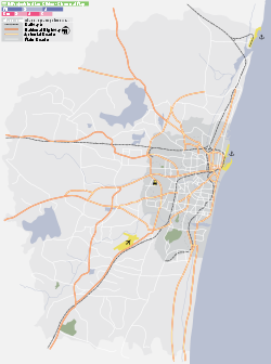
- Park Town, Chennai
-
- See also Park Town, Oxford, a street in North Oxford.
Park Town, Chennai (Madras) — neighbourhood — Coordinates 13°04′47″N 80°16′39″E / 13.0798°N 80.2776°ECoordinates: 13°04′47″N 80°16′39″E / 13.0798°N 80.2776°E Country India State Tamil Nadu District(s) Chennai District Subdistrict(s) Fort-Tondiarpet Parliamentary constituency Chennai North Assembly constituency Park Town, Chennai Planning Agency CMDA Civic agency Chennai Corporation Zone Pulianthope Ward 47 Time zone IST (UTC+05:30) Codes-
• Pincode • 600 003
Website Chennai District website Park Town (Tamil: பூங்கா நகர்) is a suburb in the north of Chennai (Madras), India. The area got its name from the People's Park which was situated near the Ripon Building. It was earlier known as White Town, as the Europeans used to stay here.
Today the area is a major transit hub with all Chennai's suburban lines converging here. It also houses several key Government offices.
Major Government landmarks include:
- Chennai Central
- Government General Hospital
- Madras Medical College
- Chennai Corporation
- Central Jail
- Southern Railway Headquarters
All four of Chennai's suburban routes cross through Park Town, which makes it a popular transit point.
Politics
Park Town assembly constituency is part of Chennai Central (Lok Sabha constituency).[1]
References
- ^ "List of Parliamentary and Assembly Constituencies". Tamil Nadu. Election Commission of India. http://archive.eci.gov.in/se2001/background/S22/TN_ACPC.pdf. Retrieved 2008-10-08.
Gallery
Park Town Next station north:
Chennai FortChennai suburban railway : MRTS Next station south:
ChintadripetStop Number:3 KM from starting:2.64 These are the stations of Chennai suburban railway - MRTS Chennai Beach | Chennai Fort | Park Town | Chintadripet | Chepauk | Tiruvallikeni | Light House | Mundagakanniamman Koil (u/c) | Thirumayilai | Mandaiveli | Greenways Road | Kotturpuram | Kasturba Nagar | Indira Nagar | Thiruvanmiyur | Taramani | Perungudi | Velachery Park Town Next station east north/north:
Chennai FortSouth West Line, Chennai Suburban Next station south/south west:
Chennai EgmoreStop number: 3 KM from starting: 3.07 These are the stations of South West Line of Chennai Suburban Railway Chennai Beach · Chennai Fort · Park Town · Chennai Egmore · Chetpet · Nungambakkam · Kodambakkam · Mambalam · Saidapet · Guindy · St. Thomas Mount · Palavanthangal · Meenambakkam · Tirusulam · Pallavaram · Chromepet · Tambaram Sanatorium · Tambaram · Perungalathur · Vandalur · Urapakkam · Guduvancheri · Potheri · Kattangulathur · Maraimalai Nagar · Singaperumal Koil · Paranur · Chengalpattu · Reddypalayam · Villiambakkam · Palur · Palayasivaram · Walajabad · Nathapettai · Kanchipuram · Tirumalpur · Thakkolam · Arakkonam Park Town Next station northbound:
Chennai FortSouth Line, Chennai Suburban Next station southbound:
Chennai EgmoreStop number: 3 KM from starting: 3.07 These are the stations of South Line of Chennai Suburban Railway Chennai Beach · Chennai Fort · Park Town · Chennai Egmore · Chetpet · Nungambakkam · Kodambakkam · Mambalam · Saidapet · Guindy · St. Thomas Mount · Palavanthangal · Meenambakkam · Tirusulam · Pallavaram · Chromepet · Tambaram Sanatorium · Tambaram · Perungalathur · Vandalur · Urapakkam · Guduvancheri · Potheri · Kattangulathur · Maraimalai Nagar · Singaperumal Koil · Paranur · Chengalpattu · Tirumani · Ottivakkam · Padalam · Karunguzhi · Madurantakam · Paakkam · Melmaruvathur · Acharapakkam · Tozhuppedu · Karasangal · Olakur · Panchalam · Tindivanam · Mailam · Perani · Vikravandi · Mundiyampakkam · Villupuram Categories:- Neighbourhoods of Chennai
- Chennai railway division
- Southern Railway (India) Zone
- Chennai MRTS stations
- Stations of Chennai Suburban Railway
- Chennai geography stubs
Wikimedia Foundation. 2010.


