- Missouri City, Missouri
-
Missouri City, Missouri — City — Location of Missouri City, Missouri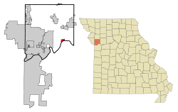
Coordinates: 39°14′17″N 94°18′4″W / 39.23806°N 94.30111°WCoordinates: 39°14′17″N 94°18′4″W / 39.23806°N 94.30111°W Country United States State Missouri County Clay Area - Total 1.1 sq mi (2.9 km2) - Land 1.0 sq mi (2.6 km2) - Water 0.1 sq mi (0.3 km2) Elevation 725 ft (221 m) Population (2000) - Total 295 - Density 290.5/sq mi (112.2/km2) Time zone Central (CST) (UTC-6) - Summer (DST) CDT (UTC-5) ZIP code 64072 Area code(s) 816 FIPS code 29-48980[1] GNIS feature ID 0730151[2] Missouri City is a city in Clay County, Missouri, United States. The population was 295 at the 2000 census.
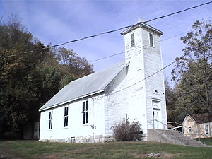 Missouri City - City Hall (Originally a Methodist church)
Contents
History
Missouri City was originally named Atchison. The earliest known use of the name was on a deed to a building from 1820. The land was possessed by French fur traders Antoine Laffond and Bernard Laffond as early as January 24, 1807. The name had changed to Missouri City by December 5, 1857.[3]
From Encyclopedia of the history of Missouri; A special charter town of about 600 inhabitants on the Missouri River, in Clay County, six miles from Liberty. The Wabash Railroad runs through it. The beginning of the place was in Williams' Landing, and a ferry established by a man named Shrewsbury Williams, at the mouth of Rose's branch, about the year 1834. About 1846 there were a dozen houses in the place and it was called Richfield. Some time later a bar formed opposite the landing and a stock company laid off a town below which they called St. Bernard. Later still another town was laid off and called New Richfield, and not long after another town was laid off and called Atchison. In 1859 St. Bernard, Richfield and Atchison were incorporated as Missouri City. There was at one time a tobacco factory in the place, and a large quantity of hemp was shipped from there. During the Civil War it was the prey of bushwhackers and jayhawkers, and its business was almost entirely destroyed, but since the building of the Wabash Railroad a considerable business has been attracted to it.[4]
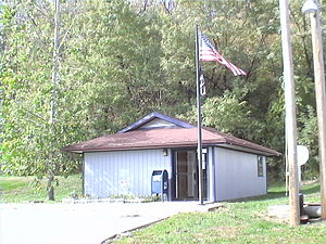 Missouri City Post Office
Geography
Missouri City is located at 39°14′17″N 94°18′04″W / 39.238147°N 94.301128°W.[5]
According to the United States Census Bureau, the city has a total area of 1.1 square miles (2.8 km2), of which, 1.0 square mile (2.6 km2) of it is land and 0.1 square miles (0.26 km2) of it (9.73%) is water.
Demographics
As of the census[1] of 2000, there were 295 people, 110 households, and 75 families residing in the city. The population density was 290.5 people per square mile (111.7/km²). There were 120 housing units at an average density of 118.2 per square mile (45.4/km²). The racial makeup of the city was 93.56% White, 2.71% African American, and 3.73% from two or more races.
There were 110 households out of which 29.1% had children under the age of 18 living with them, 52.7% were married couples living together, 8.2% had a female householder with no husband present, and 31.8% were non-families. 23.6% of all households were made up of individuals and 7.3% had someone living alone who was 65 years of age or older. The average household size was 2.68 and the average family size was 3.23.
In the city the population was spread out with 26.1% under the age of 18, 8.1% from 18 to 24, 29.8% from 25 to 44, 26.8% from 45 to 64, and 9.2% who were 65 years of age or older. The median age was 37 years. For every 100 females there were 121.8 males. For every 100 females age 18 and over, there were 107.6 males.
The median income for a household in the city was $41,875, and the median income for a family was $45,000. Males had a median income of $30,357 versus $24,554 for females. The per capita income for the city was $17,693. About 4.2% of families and 7.6% of the population were below the poverty line, including 9.1% of those under the age of eighteen and none of those sixty five or over.
References
- ^ a b "American FactFinder". United States Census Bureau. http://factfinder.census.gov. Retrieved 2008-01-31.
- ^ "US Board on Geographic Names". United States Geological Survey. 2007-10-25. http://geonames.usgs.gov. Retrieved 2008-01-31.
- ^ History of Missouri City by Oscar S. Chaney 1979,
- ^ Encyclopedia of the history of Missouri By Howard Louis Conard
- ^ "US Gazetteer files: 2010, 2000, and 1990". United States Census Bureau. 2011-02-12. http://www.census.gov/geo/www/gazetteer/gazette.html. Retrieved 2011-04-23.
External links
Kansas City Metropolitan Area's cities and counties Central city 
Largest cities (over 100,000 in 2000) Medium-sized cities (10,000 to 100,000 in 2000) Blue Springs • Belton • Excelsior Springs • Gladstone • Grandview • Lansing • Leawood • Leavenworth • Lee's Summit • Lenexa • Liberty • Merriam • Ottawa • Prairie Village • Raymore • Raytown • ShawneeCounties Municipalities and communities of Clay County, Missouri County seat: Liberty Cities Avondale | Excelsior Springs‡ | Gladstone | Glenaire | Holt‡ | Independence‡ | Kansas City‡ | Kearney | Liberty | Lawson‡ | Missouri City | Mosby | North Kansas City | Pleasant Valley | Smithville‡ | Sugar Creek‡

Villages Birmingham | Claycomo | Excelsior Estates‡ | Oaks | Oakview | Oakwood | Oakwood Park | Prathersville | Randolph
Townships Chouteau | Fishing River | Gallatin | Kearney | Liberty | Platte | Washington
Unincorporated
communityFootnotes ‡This populated place also has portions in an adjacent county or counties
Categories:- Cities in Clay County, Missouri
- Missouri populated places on the Missouri River


Wikimedia Foundation. 2010.