- Cobbs Creek, Philadelphia, Pennsylvania
-
For the stream named Cobbs Creek, see Cobbs Creek.Cobbs Creek Automobile Suburb Historic District
Location: Roughly bounded by Cobbs Creek Parkway, Spruce St., 62nd St., and Angora St.
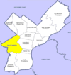
Philadelphia, PennsylvaniaCoordinates: 39°57′1″N 75°14′50″W / 39.95028°N 75.24722°W Area: 100 acres (40 ha) Built: 1880 Architect: E.A. Wilson; et al. Architectural style: Colonial Revival, Tudor Revival, Bungalow/craftsman Governing body: Local NRHP Reference#: 98001366[1] Added to NRHP: November 12, 1998 Cobbs Creek is a predominantly African American neighborhood located in the West Philadelphia section of Philadelphia, Pennsylvania, United States . Cobbs Creek is generally bound by Market Street to the north, Baltimore Ave. to the south, 52nd Street to the east, and Cobbs Creek to the west. It is often locally referred to as "The Southside", in reference to its location to the south of Market Street and above the Baltimore Ave. border of Southwest Philadelphia, as well as a neighborhood distinction used by local street gangs in the area during the 1960s and 70s. The area, originally farmland owned by the Cobb family (early Quaker colonists), was also the location of the infamous 1985 bombing of the MOVE compound by police, which resulted in a fire that consumed two city blocks.
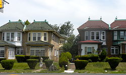
In 1998, the Cobbs Creek Automobile Suburb Historic District was created, with Cobbs Creek Parkway, Spruce St, 62nd St, and Angora St its boundaries. The District protects 1049 buildings, with Tudor Revival, Colonial Revival, and Bungalow/Craftsman architectural styles contained within the district.
Philadelphia architect William Alesker, whose latest project is a Trump Tower in Center City, and Evangelical minister Tony Campolo, one of Bill Clinton's spiritual advisers, lived, respectively, in the 6200 blocks of Pine and Delancey Streets back in the 1940s and 1950s.
Contents
Education
Public libraries
Free Library of Philadelphia operates the Blanche A. Nixon/Cobbs Creek Branch at 5800 Cobbs Creek Parkway at the intersection of 59th Street and Baltimore Avenue. The branch opened in 1925 and was renamed in 1990 after an area activist.[2]
References
- ^ "National Register Information System". National Register of Historic Places. National Park Service. 2007-01-23. http://nrhp.focus.nps.gov/natreg/docs/All_Data.html.
- ^ "Blanche A. Nixon/Cobbs Creek Branch." Free Library of Philadelphia. Retrieved on November 7, 2008.
External links
- Cobbs Creek Community Environmental Education Center
- InfoResources West Philadelphia Neighborhood - Cobbs Creek
- Historic Photographs of Cobbs Creek, PhillyHistory.org
Coordinates: 39°57′10″N 75°14′09″W / 39.952912°N 75.23592°W
Neighborhoods of the West Philadelphia section of Philadelphia, Pennsylvania Belmont • Belmont Village • Carroll Park • Cathedral Park • Cedar Park • Cobbs Creek • Dunlap • Garden Court • Haddington • Haverford North • Mantua • Mill Creek • Overbrook • Overbrook Farms • Overbrook Park • Parkside • Powelton Village • Saunders Park • Spruce Hill • Squirrel Hill • University City • Walnut Hill • Woodland Terrace • Wynnefield • Wynnefield Heights
Categories:- Historic districts in Pennsylvania
- Neighborhoods in Philadelphia, Pennsylvania
- National Register of Historic Places in Philadelphia, Pennsylvania
- Populated places in Pennsylvania with African American majority populations
- Houses on the National Register of Historic Places in Pennsylvania
- Colonial Revival architecture
- Historic districts in Philadelphia, Pennsylvania
- Pennsylvania Registered Historic Place stubs
Wikimedia Foundation. 2010.


