- National Register of Historic Places listings in Waldo County, Maine
-
 Location of Waldo County in Maine
This is a list of the National Register of Historic Places listings in Waldo County, Maine.
This is intended to be a complete list of the properties and districts on the National Register of Historic Places in Waldo County, Maine, United States. Latitude and longitude coordinates are provided for many National Register properties and districts; these locations may be seen together in a Google map.[1]
There are 56 properties and districts listed on the National Register in the county, including 1 National Historic Landmark.
-
- This National Park Service list is complete through NPS recent listings posted November 10, 2011.[2]
Contents: Counties in Maine Androscoggin - Aroostook - Cumberland - Franklin - Hancock - Kennebec - Knox - Lincoln - Oxford - Penobscot - Piscataquis - Sagadahoc - Somerset - Waldo - Washington - York Current listings
[3] Landmark name [4] Image Date listed Location City or town Summary 1 Archeological Site No. 29-64 February 22, 1982 Address Restricted Islesboro 2 Archeological Site No. 39.1 August 1, 1994 Address Restricted Searsmont 3 Bayside Historic District December 30, 1996 Roughly bounded by Penobscot Bay, Clinton Ave., George St., and Bay View Park
44°22′48″N 68°58′09″W / 44.38°N 68.969167°WBayside 4 Belfast Commercial Historic District April 4, 1980 Main St. between Church and Cross Sts.
44°25′34″N 69°00′27″W / 44.426111°N 69.0075°WBelfast 5 Belfast Historic District 
August 21, 1986 Roughly bounded by High, Grove, Elm, Congress, Main, Market, and Imrose; also 59-63 Anderson St; also 121 High St.
44°25′25″N 69°00′23″W / 44.423611°N 69.006389°WBelfast Anderson St. addresses and High St. address each represent a boundary increase 6 Belfast National Bank April 23, 1973 Main and Beaver Sts.
44°25′32″N 69°00′26″W / 44.425556°N 69.007222°WBelfast 7 Black Horse Tavern 
February 11, 1982 Searsport Ave.
44°25′44″N 68°59′02″W / 44.428889°N 68.983889°WBelfast 8 Carver Memorial Library October 14, 1993 Northeastern corner of the junction of Union and Mortland Sts.
44°27′38″N 68°55′23″W / 44.460556°N 68.923056°WSearsport 9 Hezekiah Chase House January 31, 1978 U.S. Route 202
44°36′49″N 69°19′58″W / 44.613611°N 69.332778°WUnity 10 Christ Church March 26, 1992 Off the western side of Main Rd. south of Dark Harbor
44°14′58″N 68°55′04″W / 44.2495°N 68.91767°WDark Harbor 11 Church Street Historic District November 28, 1978 Irregular pattern along Church St. from High to Franklin Sts.
44°25′23″N 69°00′14″W / 44.423056°N 69.003889°WBelfast 12 Cobe Estate October 20, 1983 North of Northport on Bluff Rd.
44°22′27″N 68°58′07″W / 44.374167°N 68.968611°WNorthport 13 College Club Inn April 14, 2000 190 W. Main St.
44°26′40″N 68°56′07″W / 44.444444°N 68.935278°WSearsport 14 Drexel Estate March 21, 1985 The Bluff
44°20′37″N 68°52′50″W / 44.343611°N 68.880556°WIslesboro 15 East Main Street Historic District December 13, 1991 U.S. Route 1 between Black Rd. and Navy St.
44°27′27″N 68°54′53″W / 44.4575°N 68.914722°WSearsport 16 First Church of Belfast 
November 7, 1976 Church St.
44°25′28″N 69°00′27″W / 44.424444°N 69.0075°WBelfast 17 Fort Knox State Park 
October 1, 1969 U.S. Route 1 near Prospect
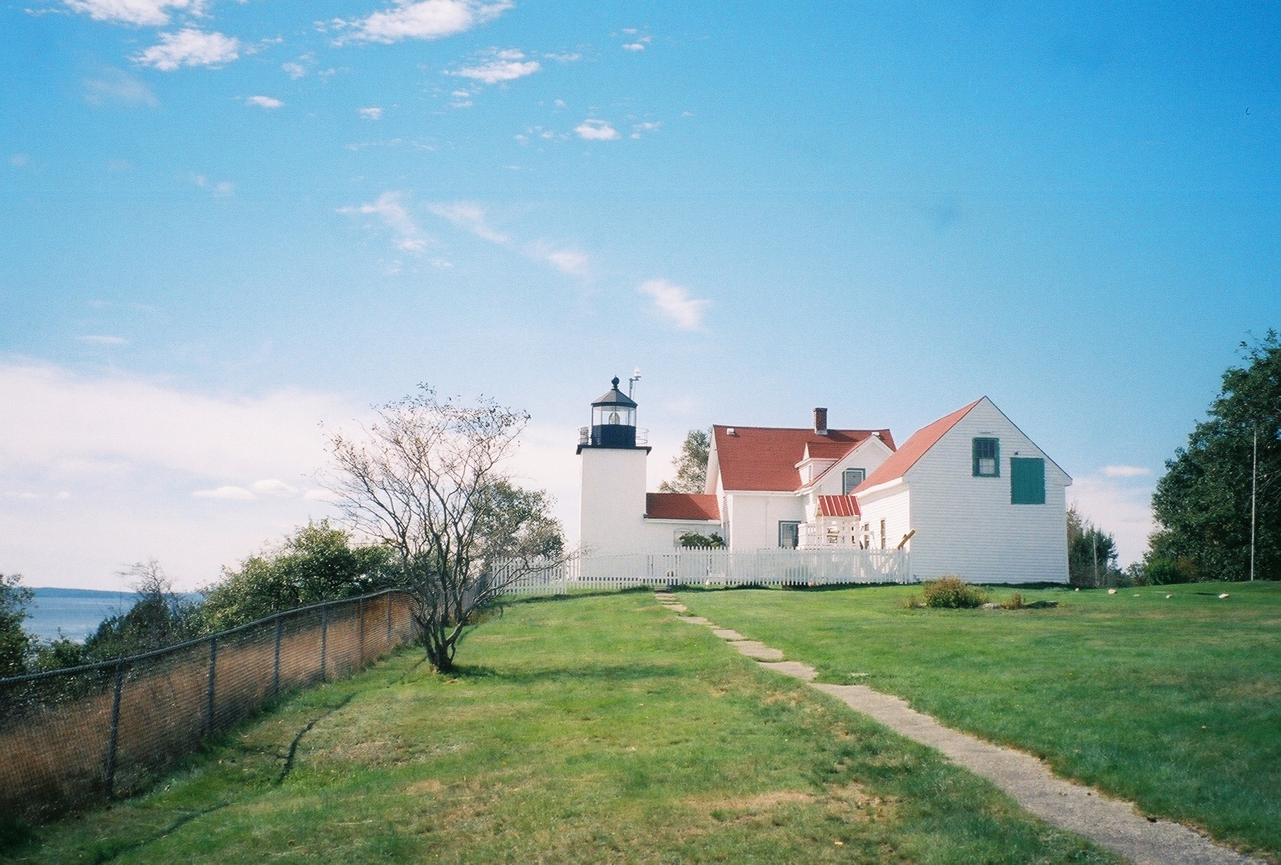
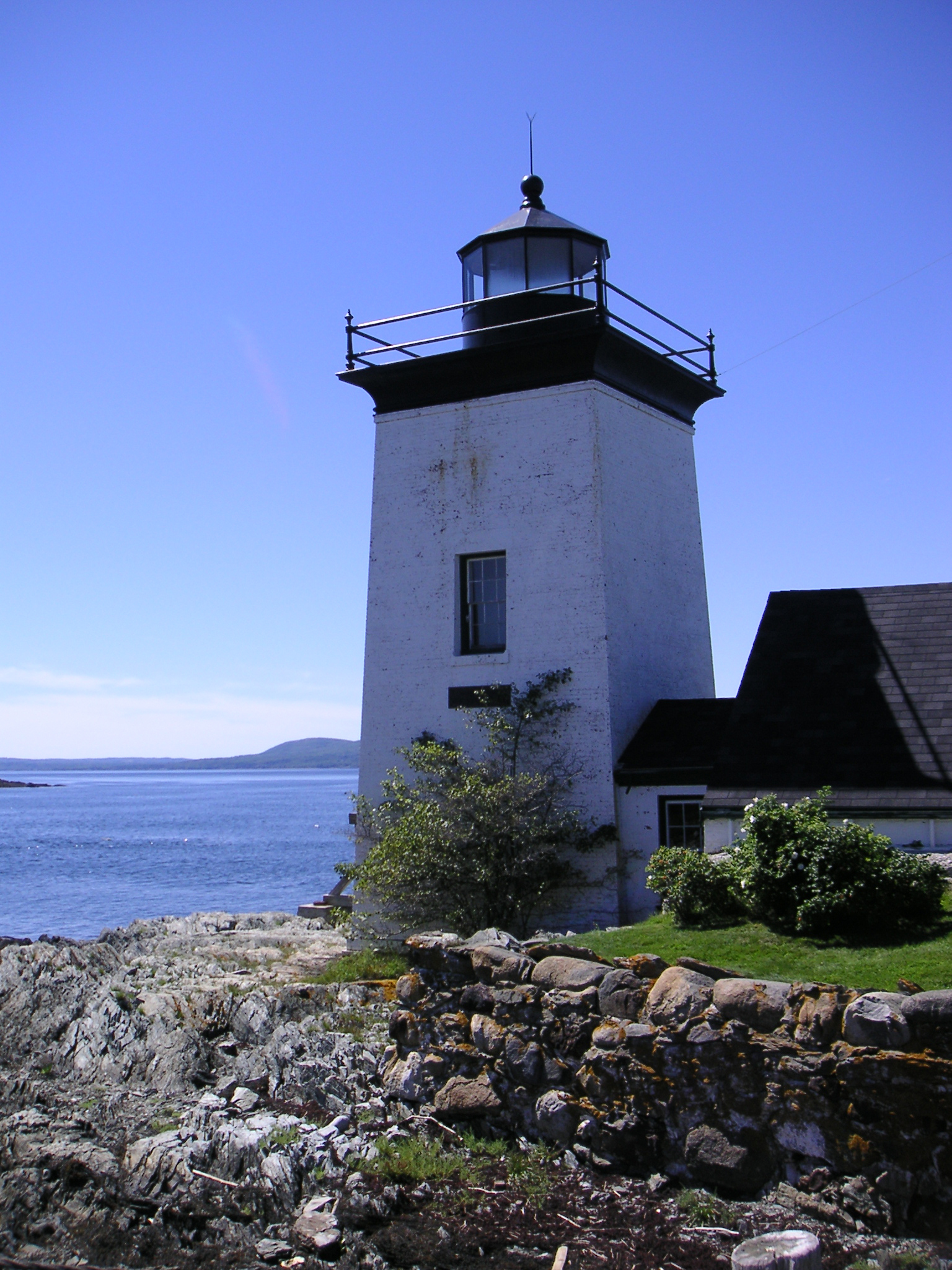
44°33′53″N 68°48′34″W / 44.564722°N 68.809444°WProspect 18 Fort Point Light Station 
March 23, 1988 Fort Point Rd.
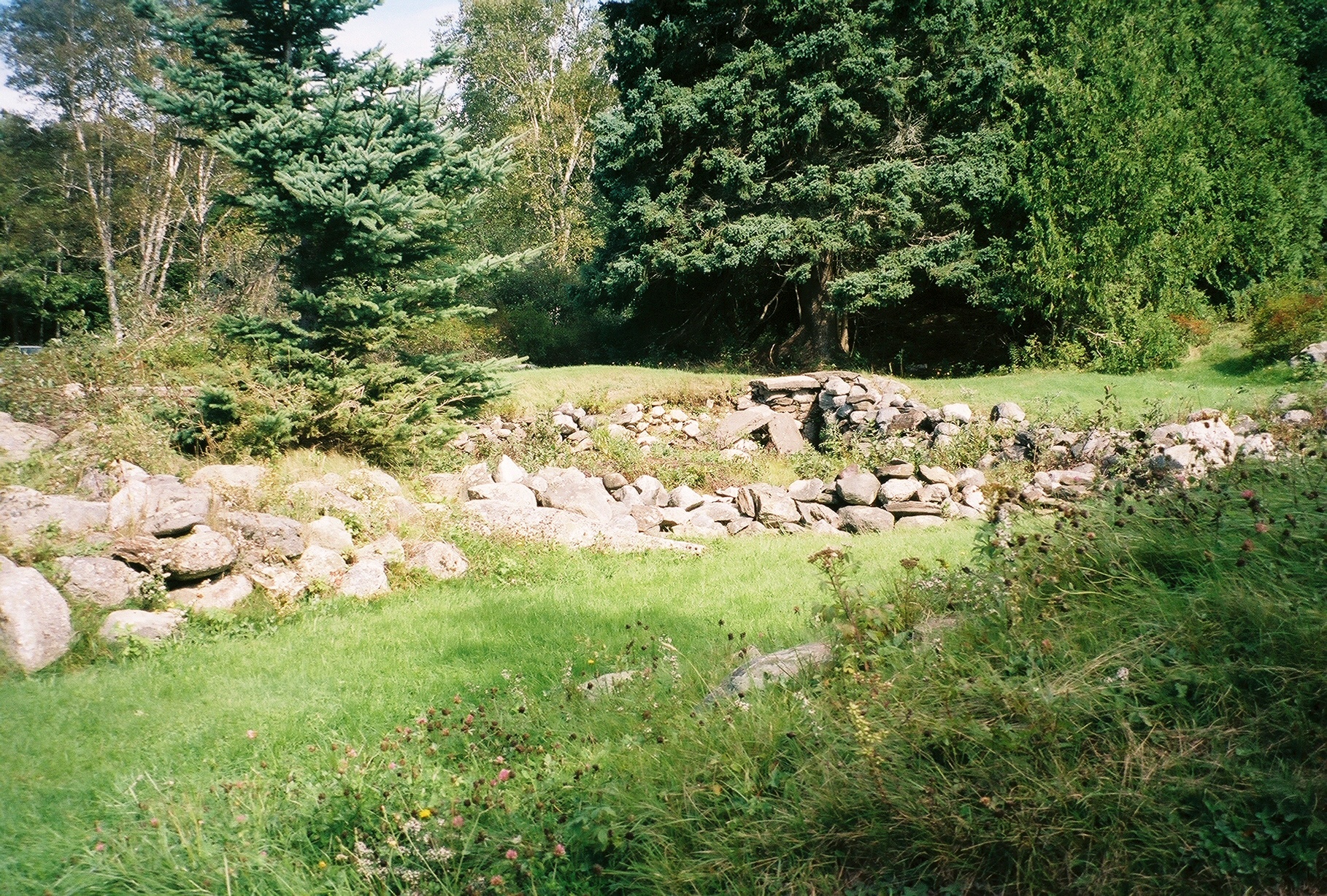
44°28′01″N 68°48′45″W / 44.466944°N 68.8125°WStockton Springs 19 Fort Pownall Memorial 
October 28, 1969 Southeast of Stockton Springs on Fort Point
44°28′05″N 68°48′46″W / 44.468056°N 68.812778°WStockton Springs 20 Frankfort Dam February 12, 2003 South of the junction of State Route 1A and the north branch of Marsh Stream
44°36′33″N 68°52′24″W / 44.609167°N 68.873333°WFrankfort 21 Free Will Baptist Church and Cemetery September 27, 1988 Church Rd.
44°21′11″N 68°53′41″W / 44.353056°N 68.894722°WNorth Islesboro 22 Georges River Canal March 5, 1970 Upper Falls on the Georges River in Warren to the Union town line, extending to Quantabacook Pond in Searsmont
44°15′N 69°15′W / 44.25°N 69.25°WSearsmont Also extends into Knox County 23 Greer's Corner School October 16, 1991 Southeastern corner of Back Belmont and Greer's Corner Rd.
44°22′28″N 69°07′48″W / 44.374444°N 69.13°WBelmont Corner 24 Grindle Point Light Station 
March 13, 1987 Ferry Rd.
44°16′53″N 68°56′36″W / 44.281389°N 68.943333°WIslesboro 25 Hardscrabble Farm March 17, 1994 Eastern side of Maine State Route 131, 0.5 miles south of its junction with State Route 173
44°21′03″N 69°11′48″W / 44.350833°N 69.196667°WSearsmont 26 Hayford Block August 29, 1977 47 Church St.
44°25′31″N 69°00′27″W / 44.425278°N 69.0075°WBelfast 27 Nathan G. Hichborn House April 7, 1988 Church St.
44°29′25″N 68°51′29″W / 44.490278°N 68.858056°WStockton Springs 28 Islesboro Free Library January 5, 1989 Main Rd.
44°18′09″N 68°54′04″W / 44.3025°N 68.901111°WIslesboro 29 Ebenezer Knowlton House January 11, 2002 Choate Rd.
44°22′44″N 69°16′03″W / 44.378889°N 69.2675°WMontville 30 Lincolnville Center Meeting House July 21, 1983 State Route 173
44°17′55″N 69°06′33″W / 44.298611°N 69.109167°WLincolnville Center 31 (Former) Maine Central Railroad Depot August 5, 2009 31 State Route 7
44°33′05″N 69°07′17″W / 44.551389°N 69.121389°WBrooks 32 Masonic Temple April 26, 1973 High St. (U.S. Route 1)
44°25′34″N 69°00′24″W / 44.426111°N 69.006667°WBelfast 33 Capt. John McGilvery House December 29, 1983 E. Main St.
44°27′31″N 68°55′00″W / 44.458611°N 68.916667°WSearsport 34 Capt. William McGilvery House December 29, 1983 E. Main St.
44°27′33″N 68°54′52″W / 44.459167°N 68.914444°WSearsport 35 Moody Farm October 31, 2002 Junction of State Route 173 and Lawry Rd.
44°21′33″N 69°08′56″W / 44.359167°N 69.148889°WSearsmont 36 Mortland Family Farm October 24, 1991 Eastern side of Mortland Rd. north of Searsport
44°28′38″N 68°55′21″W / 44.477222°N 68.9225°WSearsport 37 Mount Waldo Granite Works March 15, 1974 Address Restricted Frankfort 38 Capt. John P. Nichols House January 4, 1983 U.S. Route 1
44°27′28″N 68°54′56″W / 44.457778°N 68.915556°WSearsport 39 Old Post Office June 19, 1973 Main St. (State Route 173)
44°23′31″N 69°18′26″W / 44.391944°N 69.307222°WLiberty 40 James G. Pendleton House March 10, 1995 81 W. Main St.
44°27′10″N 68°55′59″W / 44.452778°N 68.933056°WSearsport 41 Penobscot Marine Museum July 1, 1970 Church St.
44°27′36″N 68°55′31″W / 44.46°N 68.925278°WSearsport 42 Philler Cottage April 11, 1985 Main Rd., Dark Harbor
44°15′31″N 68°54′45″W / 44.258611°N 68.9125°WIslesboro 43 Primrose Hill Historic District October 3, 1973 High and Anderson Sts.
44°25′16″N 69°00′44″W / 44.421111°N 69.012222°WBelfast 44 Stockton Springs 45 Searsport Historic District July 27, 1979 Main St.
44°27′30″N 68°55′33″W / 44.458333°N 68.925833°WSearsport 46 Springdale Farm April 24, 2000 Horseback Rd., 0.5 miles south of Troy Rd.
44°40′59″N 69°21′57″W / 44.683056°N 69.365833°WBurnham 47 Stockton Springs Community Church June 20, 1985 U.S. Route 1 and State Route 3
44°29′28″N 68°51′29″W / 44.491111°N 68.858056°WStockton Springs 48 George S. Tiffany Cottage October 16, 1989 Off Main Rd.
44°14′57″N 68°55′22″W / 44.249167°N 68.922778°WDark Harbor 49 Tranquility Grange No. 344 April 11, 2002 1 mile north of the junction of State Routes 52 and 173
44°18′21″N 69°05′52″W / 44.305833°N 69.097778°WLincolnville Center 50 George Ulmer House October 4, 2006 3 S. Cobbtown Rd.
44°17′55″N 69°00′14″W / 44.298611°N 69.003889°WLincolnville 51 Union Hall March 20, 1986 3 Reservoir St.
44°27′34″N 68°55′28″W / 44.459444°N 68.924444°WSearsport 52 Union School March 25, 1993 Eastern side of Mt. Ephraim Rd., 0.2 miles north of its junction with U.S. Route 1
44°27′38″N 68°55′43″W / 44.460556°N 68.928611°WSearsport 53 Waldo-Hancock Bridge 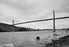
June 20, 1985 U.S. Route 1
44°33′37″N 68°48′08″W / 44.560278°N 68.802222°WProspect 54 James P. White House April 24, 1973 1 Church St.
44°25′15″N 69°00′02″W / 44.420833°N 69.000556°WBelfast 55 Winterport Congregational Church April 24, 1973 Alternate U.S. Route 1
44°38′09″N 68°50′49″W / 44.635833°N 68.846944°WWinterport 56 Winterport Historic District October 3, 1975 Irregular pattern along Main, Elm, Cushing, Lebanon, Commercial, Dean, and Water Sts.
44°38′10″N 68°50′53″W / 44.636111°N 68.848056°WWinterport See also
References
- ^ The latitude and longitude information provided in this table was derived originally from the National Register Information System, which has been found to be fairly accurate for about 99% of listings. For about 1% of NRIS original coordinates, experience has shown that one or both coordinates are typos or otherwise extremely far off; some corrections may have been made. A more subtle problem causes many locations to be off by up to 150 yards, depending on location in the country: most NRIS coordinates were derived from tracing out latitude and longitudes off of USGS topographical quadrant maps created under the North American Datum of 1927, which differs from the current, highly accurate WGS84 GPS system used by Google maps. Chicago is about right, but NRIS longitudes in Washington are higher by about 4.5 seconds, and are lower by about 2.0 seconds in Maine. Latitudes differ by about 1.0 second in Florida. Some locations in this table may have been corrected to current GPS standards.
- ^ "National Register of Historic Places: Weekly List Actions". National Park Service, United States Department of the Interior. Retrieved on November 10, 2011.
- ^ Numbers represent an ordering by significant words. Various colorings, defined here, differentiate National Historic Landmark sites and National Register of Historic Places Districts from other NRHP buildings, structures, sites or objects.
- ^ "National Register Information System". National Register of Historic Places. National Park Service. . http://nrhp.focus.nps.gov/natreg/docs/All_Data.html.
U.S. National Register of Historic Places Topics Lists by states Alabama • Alaska • Arizona • Arkansas • California • Colorado • Connecticut • Delaware • Florida • Georgia • Hawaii • Idaho • Illinois • Indiana • Iowa • Kansas • Kentucky • Louisiana • Maine • Maryland • Massachusetts • Michigan • Minnesota • Mississippi • Missouri • Montana • Nebraska • Nevada • New Hampshire • New Jersey • New Mexico • New York • North Carolina • North Dakota • Ohio • Oklahoma • Oregon • Pennsylvania • Rhode Island • South Carolina • South Dakota • Tennessee • Texas • Utah • Vermont • Virginia • Washington • West Virginia • Wisconsin • WyomingLists by territories Lists by associated states Other Municipalities and communities of Waldo County, Maine City 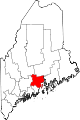
Towns CDPs Searsport | Unity | Winterport
Other
villageCategories:- National Register of Historic Places in Maine by county
- Waldo County, Maine
-


Wikimedia Foundation. 2010.