- Montville, Maine
-
Montville, Maine — Town — Location of Montville (in yellow) in Waldo County and the state of Maine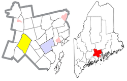
Coordinates: 44°25′48″N 69°17′6″W / 44.43°N 69.285°WCoordinates: 44°25′48″N 69°17′6″W / 44.43°N 69.285°W Country United States State Maine County Waldo Area – Total 43.1 sq mi (111.7 km2) – Land 42.6 sq mi (110.4 km2) – Water 0.5 sq mi (1.3 km2) Elevation 469 ft (143 m) Population (2000) – Total 1,002 – Density 23.5/sq mi (9.1/km2) Time zone Eastern (EST) (UTC-5) – Summer (DST) EDT (UTC-4) ZIP code 04941 Area code(s) 207 FIPS code 23-46790 GNIS feature ID 0582605 Montville is a town in Waldo County, Maine, United States. The population was 1,002 at the 2000 census.
Contents
Geography
According to the United States Census Bureau, the town has a total area of 43.1 square miles (112 km2), of which, 42.6 square miles (110 km2) of it is land and 0.5 square miles (1.3 km2) of it (1.16%) is water.
Demographics
As of the census[1] of 2000, there were 1,002 people, 391 households, and 279 families residing in the town. The population density was 23.5 people per square mile (9.1/km²). There were 483 housing units at an average density of 11.3 per square mile (4.4/km²). The racial makeup of the town was 98.00% White, 0.10% African American, 0.10% Native American, 0.10% Asian, 0.90% from other races, and 0.80% from two or more races. Hispanic or Latino of any race were 1.00% of the population.
There were 391 households out of which 35.8% had children under the age of 18 living with them, 59.1% were married couples living together, 5.9% had a female householder with no husband present, and 28.4% were non-families. 21.0% of all households were made up of individuals and 6.9% had someone living alone who was 65 years of age or older. The average household size was 2.56 and the average family size was 3.00.
In the town the population was spread out with 26.4% under the age of 18, 6.7% from 18 to 24, 29.7% from 25 to 44, 27.3% from 45 to 64, and 9.8% who were 65 years of age or older. The median age was 37 years. For every 100 females there were 102.4 males. For every 100 females age 18 and over, there were 100.3 males.
The median income for a household in the town was $32,434, and the median income for a family was $37,917. Males had a median income of $25,391 versus $23,583 for females. The per capita income for the town was $14,112. About 9.9% of families and 14.5% of the population were below the poverty line, including 18.0% of those under age 18 and 12.2% of those age 65 or over.
Notable people
- Ebenezer Knowlton, congressman, minister, co-founder of Bates College.
Historic Sites in Montville
- Ebenezer Knowlton House
References
- ^ "American FactFinder". United States Census Bureau. http://factfinder.census.gov. Retrieved 2008-01-31.
External links
Municipalities and communities of Waldo County, Maine City 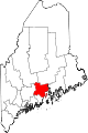
Towns CDPs Searsport | Unity | Winterport
Other
villageCategories:- Towns in Waldo County, Maine


Wikimedia Foundation. 2010.