- Morrill, Maine
-
Morrill, Maine — Town — Location of Morrill (in yellow) in Waldo County and the state of Maine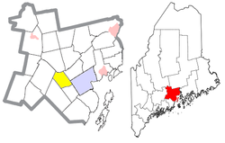
Coordinates: 44°25′42″N 69°10′18″W / 44.42833°N 69.17167°W Country United States State Maine County Waldo Area – Total 17.0 sq mi (44.2 km2) – Land 16.6 sq mi (42.9 km2) – Water 0.5 sq mi (1.3 km2) Elevation 240 ft (73 m) Population (2000) – Total 774 – Density 46.7/sq mi (18.0/km2) Time zone Eastern (EST) (UTC-5) – Summer (DST) EDT (UTC-4) ZIP code 04952 Area code(s) 207 FIPS code 23-47245 GNIS feature ID 0582608 Morrill is a town in Waldo County, Maine, United States. The population was 774 at the 2000 census.
Contents
Geography
According to the United States Census Bureau, the town has a total area of 17.0 square miles (44 km2), of which, 16.6 square miles (43 km2) of it is land and 0.5 square miles (1.3 km2) of it (2.87%) is water.
Demographics
As of the census[1] of 2000, there were 774 people, 299 households, and 217 families residing in the town. The population density was 46.7 people per square mile (18.0/km²). There were 331 housing units at an average density of 20.0 per square mile (7.7/km²). The racial makeup of the town was 97.93% White, 0.13% Native American, 0.65% Asian, and 1.29% from two or more races. Hispanic or Latino of any race were 0.39% of the population.
There were 299 households out of which 35.5% had children under the age of 18 living with them, 61.9% were married couples living together, 9.4% had a female householder with no husband present, and 27.4% were non-families. 20.7% of all households were made up of individuals and 8.4% had someone living alone who was 65 years of age or older. The average household size was 2.59 and the average family size was 3.00.
In the town the population was spread out with 26.7% under the age of 18, 5.9% from 18 to 24, 30.4% from 25 to 44, 26.0% from 45 to 64, and 11.0% who were 65 years of age or older. The median age was 37 years. For every 100 females there were 92.5 males. For every 100 females age 18 and over, there were 92.2 males.
The median income for a household in the town was $34,583, and the median income for a family was $36,250. Males had a median income of $29,750 versus $25,096 for females. The per capita income for the town was $15,596. About 13.0% of families and 13.1% of the population were below the poverty line, including 19.2% of those under age 18 and 16.7% of those age 65 or over.
History
Morrill is situated in the central part of Waldo County, 6½ miles west of Belfast. It is bounded on the north by Knox, east by Waldo and Belfast, south by Belmont, and west by Searsmont and Montville. The surface of the town is uneven, but with very little waste land. Morey and Rowe hills are probably the highest elevations, though these have no great altitude. The soil is sandy in parts, and in others clay loam. Hay and potatoes are the chief crops. The usual forest trees of the region thrive here. Cross Pond, in this town, contains about 100 acres (40 ha), and another—Dolliff—about 50 acres (200,000 m2). The chief water-power is at the village on the east on the Passagassawakeag Stream. There are here shingle and stave mills, and a horse-rake factory. Morrill is on the Belfast and Kendall’s Mills stage-line. The nearest railroad station is at Belfast. The town roads are very good. There is one bridge 120 feet (37 m) in length, constructed of stone and timber.
This town was incorporated March 3, 1855; being named in honor of Hon. Anson P. Morrill, then governor of the State. The first settlements were made by James Weymouth, Benjamin Smith, Joseph Corning and Nathaniel Cushman, in 1801 and 1802. They purchased their lands of General Henry Knox, proprietor under the Waldo Patent.
The climate of this town is regarded as quite healthful. There are four inhabitants past eighty years of age, and four between seventy and eighty. The Grange has a good building here, which is used as a townhall. There is a Methodist society in the town, and a Union meetinghouse at the village. The town has five public schoolhouses. The entire school property is valued at $2,500. The valuation of estates in 1870 was $133,099. In 1880 it was $122,098. The rate of taxation in the latter was for money tax, 42 mills on the dollar. The population in 1870 was 523. In 1880 it was 494.
History of Morrill, Maine, from A Gazetteer of the State of Maine, By Geo. J. Varney Published by B. B. Russell, 57 Cornhill, Boston 1886
Quantabacook Lake
Recreation
Quantabacook Lake - Along with nearby ponds, a 15-mile (24 km) stretch of the St. George River, from Appleton to Warren, supports an assemblage of rare plants, invertebrates, and natural communities that is found nowhere else in central or coastal Maine. The River meanders from its headwaters above Quantabacook Lake southward through Searsmont, Appleton, Union, and Warren. An outstanding unpatterned fern ecosystem buts the northeast end of Quantabacook Lake. Boat access is available off Route 3. Look and listen for Loons once you're on the water.
Nature & Wildlife Sanctuary
A privately owned nature and wildlife sanctuary is at the head (north)of Quantabacook Lake along Route 3, this sanctuary includes a small islet (Converse Island) approximately 2 acres (8,100 m2) in size, and a few rock outcroppings in Quantabacook Lake. (Location coordinates: 44.4022, -69.16799)
Schools
Ames Elementary—Gladys Weymouth Schools
Weymouth School is located in Morrill, Maine. It contains 6 classrooms: 2 kindergarten, 2 first and 2 second grades. Support services include 1 special ed tech, and 1 Reading Recover/literacy teacher. We have one full time administrative assistant that serves both schools, 1 custodian and 1 kitchen cook.
Ames School is located in Searsmont, Maine. It contains 8 classrooms: 2 third, 2 fourth and 2 fifth grade classrooms and 1 behavior day treatment program. New to our school this year is the Pre-K program that services 4 year olds from the Tri-Town area. This classroom has a full time teacher, one full timeassistant teacher and a part time ed tech. It is a full day program. Support staff include 4 ed techs that support day treatment students inclusively in regular ed classrooms, 1 special education teacher that supports students inclusively in their classrooms and works with the ed tech at the Weymouth School to deliver services there for our K-2 students, 1 literacy teacher, 1 secretary, 1 custodian and 1 kitchen cook.
Historical Society
The Morrill Historical Society was first organized in 1935 and is now moving ahead with a refocused vision. Plans are underway to have our first framed building, The Smith House built in 1805 and in the process of repair, available for tours in the near future. The society has been active throughout the years in producing publications and a video, which are currently available. Open - April- October. Hours - By appointment, meetings are held the last Thursday of every month at 7pm. Address: PO Box 235, Morrill, ME 04952, Phone: 207-342-3535, Email: morrillhistoricalsociety@earthlink.net
Local Landmarks
Local landmarks include Bartlett Stream Reservoir (44.4084073 -69.2211529), Converse Island (44.3999002 -69.1740011), Dolliff Pond (44.4211851 -69.1903184), Green Wood Cemetery (44.4259067 -69.2414312), Hillcrest Cemetery (44.4081297 -69.2133748), Little Pond (44.3881302 -69.1972633), Merrill Point (44.4050744 -69.1839293), Morey Hill (44.4397959 -69.1861516), Quantabacook Lake (44.3889637 -69.1772626), Quantabacook Lake Dam (44.3700751 -69.1828183), Ruffingham Meadow State Game Management Area (44.4078516 -69.2392090), Ruffingham Meadows Dam (44.4084073 -69.2211529), Sheep Island (44.3925747 -69.1803182), Thompson Brook (44.4128516 -69.2311532), Wilson Brook (44.4022966 -69.1958743), Witcher Swamp (44.3809077 -69.2417093), Wood Island (44.4050744 -69.1836516).
References
- ^ "American FactFinder". United States Census Bureau. http://factfinder.census.gov. Retrieved 2008-01-31.
External links
- SAD 34, Belfast-Belmont-Morrill-Northport-Searsmont-Swanville, Maine
- Morrill Historical Society
- Maine Genealogy: Morrill, Waldo County, Maine
Municipalities and communities of Waldo County, Maine City 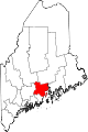
Towns CDPs Searsport | Unity | Winterport
Other
villageCoordinates: 44°26′35″N 69°08′57″W / 44.44306°N 69.14917°W
Categories:- Towns in Waldo County, Maine


Wikimedia Foundation. 2010.