- National Register of Historic Places listings in Oxford County, Maine
-
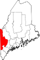
 Location of Oxford County in Maine
This is a list of the National Register of Historic Places listings in Oxford County, Maine.
This is intended to be a complete list of the properties and districts on the National Register of Historic Places in Oxford County, Maine, United States. Latitude and longitude coordinates are provided for many National Register properties and districts; these locations may be seen together in a Google map.[1]
There are 89 properties and districts listed on the National Register in the county.
-
- This National Park Service list is complete through NPS recent listings posted November 10, 2011.[2]
Contents: Counties in Maine Androscoggin - Aroostook - Cumberland - Franklin - Hancock - Kennebec - Knox - Lincoln - Oxford - Penobscot - Piscataquis - Sagadahoc - Somerset - Waldo - Washington - York Current listings
[3] Landmark name [4] Image Date listed Location City or town Summary 1 Albany Town House August 7, 2007 Junction of State Routes 5 and 35
44°19′27″N 70°46′10″W / 44.324167°N 70.769444°WAlbany Township 2 Andover Hook and Ladder Company Building January 11, 2001 39 Elm St.
44°38′10″N 70°44′59″W / 44.636111°N 70.749722°WAndover 3 Andover Public Library January 27, 1981 Church St.
44°37′54″N 70°45′07″W / 44.631667°N 70.751944°WAndover 4 Barrows-Steadman Homestead April 12, 1982 134 Main St.
44°01′04″N 70°58′47″W / 44.017778°N 70.979722°WFryeburg 5 Bell Hill Meetinghouse July 10, 2003 191 Bell Hill Rd.
44°05′17″N 70°33′36″W / 44.088056°N 70.56°WOtisfield 6 Bell Hill School July 10, 2003 185 Bell Hill Rd.
44°05′15″N 70°33′35″W / 44.0875°N 70.559722°WOtisfield 7 Bennett Bridge February 16, 1970 1.5 miles south of Wilsons Mills off State Route 16, over the Magalloway River
44°55′04″N 71°02′21″W / 44.917778°N 71.039167°WWilsons Mills 8 Nathaniel and Elizabeth Bennett House June 7, 1996 Western side of Crockett Ridge Rd., 1.4 miles north of its junction with State Route 117
44°13′57″N 70°34′31″W / 44.2325°N 70.575278°WNorway 9 Brickett Place July 28, 1982 State Route 113
44°16′03″N 71°00′18″W / 44.2675°N 71.005°WStow 10 Broad Street Historic District December 28, 1977 Broad St. and the Common; also along Church and Park Sts.
44°24′07″N 70°47′23″W / 44.401944°N 70.789722°WBethel Second set of addresses represents a boundary increase 11 Center Meeting House and Common 
June 20, 1997 476 Main St.
44°08′18″N 70°28′18″W / 44.138333°N 70.471667°WOxford 12 Squire Chase House May 7, 1979 151 Main St.
44°01′15″N 70°58′34″W / 44.020833°N 70.976111°WFryeburg 13 Church of the New Jerusalem June 13, 1986 4 Oxford St.
44°00′56″N 70°58′51″W / 44.015556°N 70.980833°WFryeburg 14 Churchill Bridge March 17, 1994 Mountain Rd. across Bicknell Brook, 1.0 mile west of its junction with Sodom Rd.
44°14′44″N 70°23′10″W / 44.245556°N 70.386111°WBuckfield 15 Cole Block April 1, 1998 19 Main St.
44°24′26″N 70°47′33″W / 44.407222°N 70.7925°WBethel 16 Deacon Hutchins House July 10, 1979 Northwest of Rumford on State Route 5
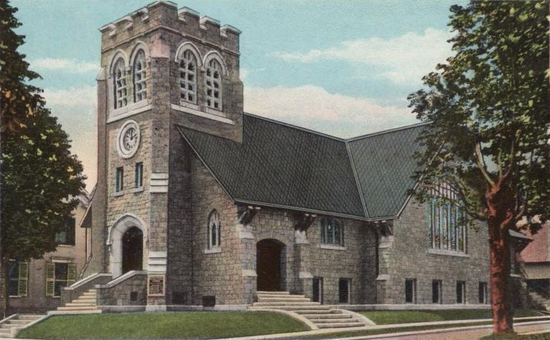
44°32′47″N 70°41′42″W / 44.546389°N 70.695°WRumford 17 Deering Memorial United Methodist Church 
January 24, 2008 39 Main St.
44°13′23″N 70°30′55″W / 44.223056°N 70.515278°WParis Sidney Badgley and William H. Nicklas, architects (1911). 18 District No. 1 Schoolhouse July 19, 1984 98 Main St.
44°00′54″N 70°58′57″W / 44.015°N 70.9825°WFryeburg 19 Dreamhome September 27, 1996 Western side of Lake Christopher, 0.45 miles north of Hill Rd.
44°22′16″N 70°39′10″W / 44.371111°N 70.652778°WBryant Pond 20 Eastman Hill Rural Historic District June 8, 1993 Eastman Hill Rd. east of Center Lovell
44°10′17″N 70°52′17″W / 44.171389°N 70.871389°WCenter Lovell 21 First Universalist Society of West Sumner August 9, 2002 1114 Main St.
44°21′58″N 70°27′40″W / 44.366111°N 70.461111°WSumner 22 Forest Lodge December 30, 2008 Carry Rd., about 1.9 miles west of Middle Dam Upton 23 Foster Family Home November 9, 1994 Western side of Sunday River Rd., 1.5 miles northwest of its junction with Skiway Rd.
44°29′08″N 70°51′14″W / 44.485556°N 70.853889°WNewry 24 Fryeburg Registry of Deeds December 30, 1987 96 Main St.
44°00′53″N 70°58′59″W / 44.014722°N 70.983056°WFryeburg 25 Fryeburg Town House, Former October 2, 1992 Eastern side of State Route 5, 0.1 miles north of its junction with Woodlawn Ave.
44°04′14″N 70°56′43″W / 44.070556°N 70.945278°WFryeburg Center 26 Gehring Clinic August 2, 1976 Off State Route 5
44°23′58″N 70°47′16″W / 44.399444°N 70.787778°WBethel 27 Greenwood Cattle Pound August 7, 2007 Greenwood Rd., 0.33 miles north of State Route 219
44°19′21″N 70°39′18″W / 44.3225°N 70.655°WGreenwood 28 Greenwood Town Hall, Former January 11, 2001 270 Main St.
44°24′04″N 70°42′22″W / 44.401111°N 70.706111°WLocke Mills 29 Hall House October 31, 2002 10 Kilborn St.
44°24′25″N 70°47′09″W / 44.406944°N 70.785833°WBethel 30 Enoch Hall House December 23, 1993 Western side of Bean Rd., 0.5 miles southeast of its junction with State Route 117
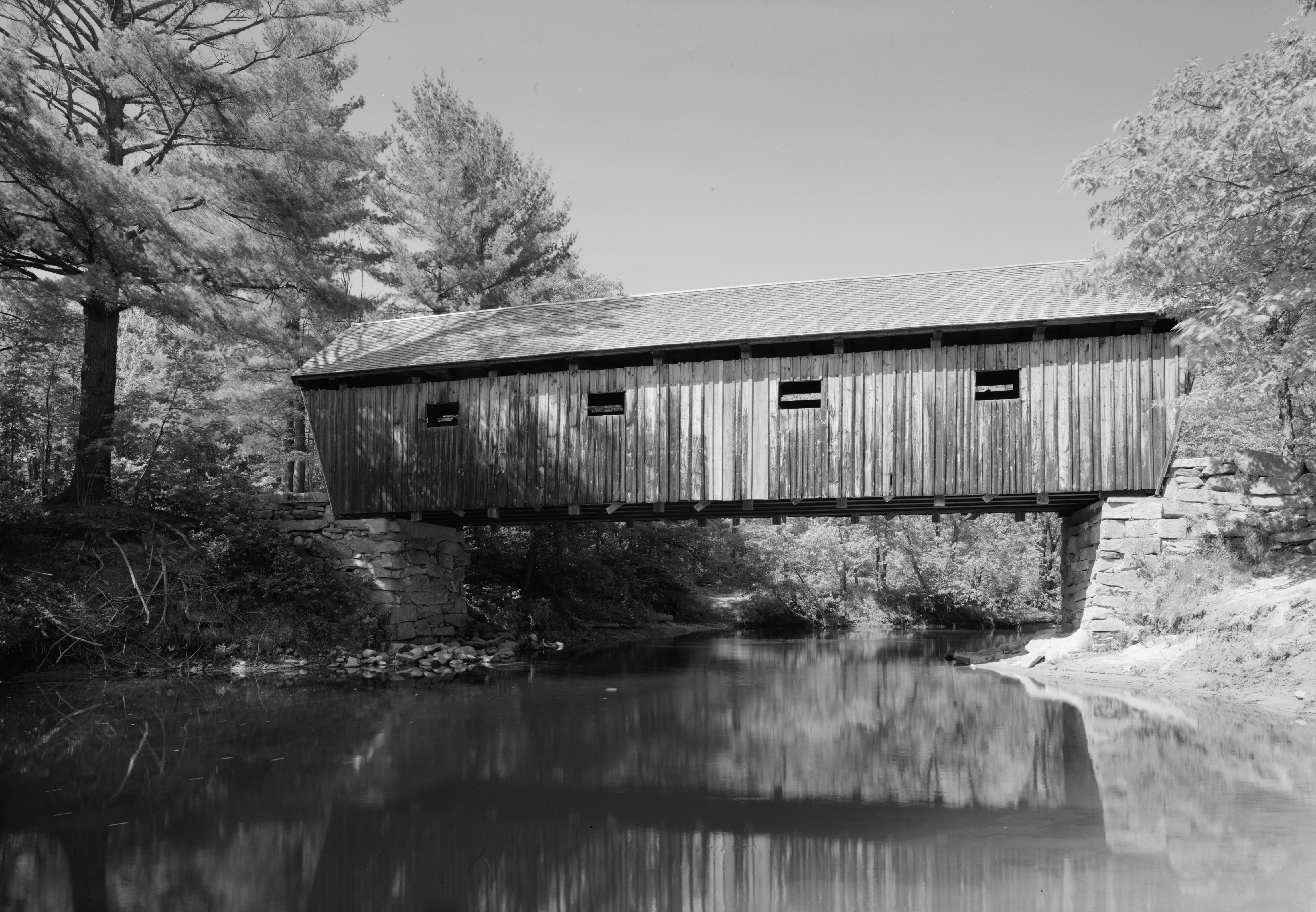
44°16′57″N 70°20′38″W / 44.2825°N 70.343889°WBuckfield 31 Hemlock Bridge February 16, 1970 Northeast of Fryeburg Center, over the Old Course Saco River
44°04′46″N 70°54′13″W / 44.079444°N 70.903611°WFryeburg Center 32 Hershey Plow Company Building June 14, 1990 Hill St. near Stony Brook
44°13′21″N 70°30′25″W / 44.2225°N 70.506944°WSouth Paris 33 Hubbard-Cotton Store June 14, 1990 State Routes 5/113 across the Saco River from their junction with State Route 117
43°52′28″N 70°48′19″W / 43.874444°N 70.805278°WHiram 34 Moses Hutchins House April 22, 2003 Junction of State Route 6 and Old Stage Rd.
44°08′51″N 70°53′02″W / 44.1475°N 70.883889°WLovell 35 J&O Irish Store December 29, 1983 State Route 140
44°22′22″N 70°20′52″W / 44.372778°N 70.347778°WHartford 36 Zadoc Long Free Library June 24, 1994 Southern side of State Route 117 at its junction with State Route 140
44°17′22″N 70°21′55″W / 44.289444°N 70.365278°WBuckfield John Calvin Stevens, architect (1900-01). 37 Lovejoy Bridge 
February 16, 1970 Over the Ellis River
44°35′37″N 70°44′02″W / 44.593611°N 70.733889°WSouth Andover 38 Lovell Village Church June 20, 1986 Church St.
44°07′40″N 70°53′36″W / 44.127778°N 70.893333°WLovell Ammi Cutter, architect (1851). 39 Lower Sunday River School May 23, 1978 Southwest of Newry on Sunday River Rd.
44°28′20″N 70°49′57″W / 44.472222°N 70.8325°WNewry 40 Main Street Historic District March 22, 1991 Main Street from Portland St. to about Swans Falls Rd.
44°01′15″N 70°58′35″W / 44.020833°N 70.976389°WFryeburg 41 Maine Archaeological Survey site 21.26 September 5, 1997 Address restricted Lovell 42 Arthur L. Mann Memorial Library January 5, 1989 Main St.
44°19′30″N 70°34′27″W / 44.325°N 70.574167°WWest Paris 43 Dr. Moses Mason House October 17, 1972 Broad St.
44°24′18″N 70°47′32″W / 44.405°N 70.792222°WBethel 44 McLaughlin House and Garden October 27, 2000 97 Main St.
44°13′08″N 70°31′03″W / 44.218889°N 70.5175°WSouth Paris 45 McWain-Hall House March 25, 1987 McWain Hill Rd.
44°11′14″N 70°40′10″W / 44.187222°N 70.669444°WWaterford 46 Mechanic Institute May 13, 1980 44-56 Congress St.
44°32′46″N 70°32′45″W / 44.546111°N 70.545833°WRumford 47 Merrill-Poor House May 17, 1976 Northeast of Andover on State Route 120
44°38′09″N 70°44′19″W / 44.635833°N 70.738611°WAndover 48 Middle Intervale Meeting House and Common June 26, 1998 757 Intervale Rd.
44°27′51″N 70°47′11″W / 44.464167°N 70.786389°WBethel 49 Municipal Building May 13, 1980 Congress St.
44°32′48″N 70°32′47″W / 44.546667°N 70.546389°WRumford 50 North Waterford Congregational Church June 13, 1986 Off State Route 35
44°16′57″N 70°46′24″W / 44.2825°N 70.773333°WNorth Waterford 51 Norway Historic District July 21, 1988 Roughly bounded by Pearl St., Danforth St. and Greenleaf Ave., Pennesseewassee Stream, and Main and Whitman Sts.
44°12′49″N 70°32′31″W / 44.213611°N 70.541944°WNorway 52 The Nutting Homestead December 3, 1974 South of Otisfield off State Route 121
44°04′14″N 70°32′37″W / 44.070556°N 70.543611°WOtisfield 53 Osgood Family House April 5, 1990 Main St.
44°00′42″N 70°59′15″W / 44.011667°N 70.9875°WFryeburg 54 Otisfield Town House (Former) February 15, 2005 53 Bell Hill Rd.
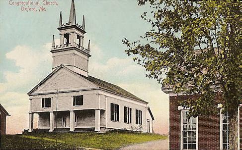
44°04′54″N 70°33′14″W / 44.081667°N 70.553889°WOtisfield 55 Oxford Congregational Church and Cemetery 
June 24, 1994 Eastern side of King St., 0.2 miles north of its junction with State Route 121
44°08′02″N 70°29′30″W / 44.133889°N 70.491667°WOxford 56 Paris Hill Historic District 
June 19, 1973 Main St. and Hannibal Hamlin Dr., east to Mt. Mica and Christian Ridge Rds.
44°15′44″N 70°30′07″W / 44.262222°N 70.501944°WParis Hill 57 Paris Public Library 
January 5, 1989 3 Main St.
44°13′24″N 70°30′53″W / 44.223333°N 70.514722°WSouth Paris John Calvin Stevens, architect. 58 Marion Parsons House January 23, 1987 90 Main St.
44°00′51″N 70°59′01″W / 44.014167°N 70.983611°WFryeburg 59 Peabody Tavern December 13, 1976 East of Gilead on U.S. Route 2
44°23′55″N 70°56′07″W / 44.398611°N 70.935278°WGilead 60 John M. Philbrook House December 14, 1995 32 Main St.
44°24′20″N 70°47′27″W / 44.405556°N 70.790833°WBethel 61 Samuel D. Philbrook House March 10, 1995 162 Main St.
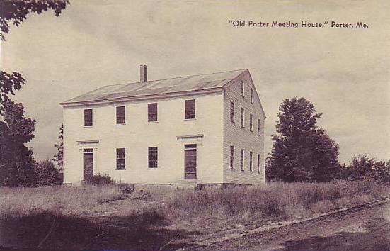
44°24′35″N 70°47′21″W / 44.409722°N 70.789167°WBethel 62 Porter Old Meetinghouse 
April 2, 1973 North of Porter off State Route 25
43°49′05″N 70°56′50″W / 43.818056°N 70.947222°WPorter 63 Porter-Parsonfield Bridge February 16, 1970 0.5 miles south of Porter over the Ossipee River
43°47′30″N 70°56′18″W / 43.791667°N 70.938333°WPorter Extends into York County 64 E.C. and M.I. Record Homestead August 24, 2011 8 Bean Rd.
44°17′11″N 70°20′49″W / 44.286389°N 70.346944°WBuckfield 65 Rivercroft Farm July 16, 2008 55, 59, and 60 River St.
44°01′05″N 70°59′32″W / 44.018056°N 70.992222°WFryeburg 66 Robinson-Parsons Farm February 4, 1982 Town Farm Brook Rd.
44°11′28″N 70°29′59″W / 44.191111°N 70.499722°WParis 67 Rumford Falls I-IV Site November 14, 1992 Address Restricted South Rumford 68 Rumford Falls Power Company Building May 13, 1980 59 Congress St.
44°32′41″N 70°32′47″W / 44.544722°N 70.546389°WRumford 69 Rumford Falls V Site November 14, 1992 Address Restricted South Rumford 70 Rumford Point Congregational Church 
June 20, 1985 Junction of U.S. Route 2 and State Route 5
44°30′03″N 70°40′18″W / 44.500833°N 70.671667°WRumford Jonathan Adams Bartlett, architect (1865). 71 Rumford Public Library 
January 5, 1989 Rumford Ave.
44°32′49″N 70°32′58″W / 44.546944°N 70.549444°WRumford John Calvin Stevens, architect (1903). 72 Levi Sargent House March 13, 1987 Otisfield Gore Rd.
44°08′58″N 70°33′52″W / 44.149444°N 70.564444°WOtisfield 73 Soldiers Memorial Library October 16, 2008 85 Main St.
43°52′56″N 70°47′52″W / 43.88217°N 70.79772°WHiram 74 Stearns Hill Farm February 11, 2009 90 Stearns Hill Rd.
44°17′13″N 70°31′18″W / 44.287071°N 70.521777°WWest Paris 75 Elisha F. Stone House April 28, 1983 Gothic St.
44°13′29″N 70°30′54″W / 44.224722°N 70.515°WSouth Paris 76 Strathglass Building 
May 13, 1980 33 Hartford St.
44°32′46″N 70°32′45″W / 44.546111°N 70.545833°WRumford 77 Strathglass Park District 
October 18, 1974 Bounded by Lincoln Ave., Hancock St., Maine Ave., and York St.
44°33′03″N 70°33′06″W / 44.550833°N 70.551667°WRumford 78 Sturtevant Hall 
September 19, 1977 State Route 119
44°12′02″N 70°24′34″W / 44.200556°N 70.409444°WHebron John Calvin Stevens, architect (1891). 79 Sunday River Bridge 
February 16, 1970 West of Newry, over the Sunday River
44°29′31″N 70°50′36″W / 44.491944°N 70.843333°WNewry 80 Town of Rumford Site November 14, 1992 Address Restricted Rumford 81 Union Church 
June 22, 1980 Off State Route 140
44°17′40″N 70°22′13″W / 44.294444°N 70.370278°WBuckfield 82 Upton Grange No. 404 (Former) October 12, 2000 Junction of State Route 26 and Mill Rd.
44°41′40″N 71°00′43″W / 44.694444°N 71.011944°WUpton 83 Vail Site January 23, 1980 Address Restricted Parkertown Township 84 Wadsworth Hall January 21, 1974 South of Hiram
43°51′48″N 70°48′47″W / 43.863333°N 70.813056°WHiram 85 David Warren House April 28, 1983 Off State Route 140
44°19′26″N 70°21′04″W / 44.323889°N 70.351111°WHartford 86 Waterford Historic District 
April 24, 1980 State Routes 35 and 37
44°10′54″N 70°43′1″W / 44.18167°N 70.71694°W
Boundary increase (listed August 23, 2011): 30 Valley RdWaterford 87 John Watson House December 31, 1974 1 mile northwest of Hiram off State Route 117
43°53′51″N 70°48′53″W / 43.8975°N 70.814722°WHiram 88 Whitman Memorial Library January 12, 1995 1 mile southwest of the junction of State Routes 26 and 232
44°22′46″N 70°38′39″W / 44.379444°N 70.644167°WBryant Pond 89 Benjamin Wiley House November 10, 1980 Southeast of North Fryeburg on Fish St.
44°06′18″N 70°57′44″W / 44.105°N 70.962222°WNorth Fryeburg See also
References
- ^ The latitude and longitude information provided in this table was derived originally from the National Register Information System, which has been found to be fairly accurate for about 99% of listings. For about 1% of NRIS original coordinates, experience has shown that one or both coordinates are typos or otherwise extremely far off; some corrections may have been made. A more subtle problem causes many locations to be off by up to 150 yards, depending on location in the country: most NRIS coordinates were derived from tracing out latitude and longitudes off of USGS topographical quadrant maps created under North American Datum of 1927, which differs from the current, highly accurate GPS system used by Google maps. Chicago is about right, but NRIS longitudes in Washington are higher by about 4.5 seconds, and are lower by about 2.0 seconds in Maine. Latitudes differ by about 1.0 second in Florida. Some locations in this table may have been corrected to current GPS standards.
- ^ "National Register of Historic Places: Weekly List Actions". National Park Service, United States Department of the Interior. Retrieved on November 10, 2011.
- ^ Numbers represent an ordering by significant words. Various colorings, defined here, differentiate National Historic Landmark sites and National Register of Historic Places Districts from other NRHP buildings, structures, sites or objects.
- ^ "National Register Information System". National Register of Historic Places. National Park Service. . http://nrhp.focus.nps.gov/natreg/docs/All_Data.html.
U.S. National Register of Historic Places Topics Lists by states Alabama • Alaska • Arizona • Arkansas • California • Colorado • Connecticut • Delaware • Florida • Georgia • Hawaii • Idaho • Illinois • Indiana • Iowa • Kansas • Kentucky • Louisiana • Maine • Maryland • Massachusetts • Michigan • Minnesota • Mississippi • Missouri • Montana • Nebraska • Nevada • New Hampshire • New Jersey • New Mexico • New York • North Carolina • North Dakota • Ohio • Oklahoma • Oregon • Pennsylvania • Rhode Island • South Carolina • South Dakota • Tennessee • Texas • Utah • Vermont • Virginia • Washington • West Virginia • Wisconsin • WyomingLists by territories Lists by associated states Other  Category:National Register of Historic Places •
  Portal:National Register of Historic Places
Municipalities and communities of Oxford County, Maine County seat: Paris Towns Andover | Bethel | Brownfield | Buckfield | Byron | Canton | Denmark | Dixfield | Fryeburg | Gilead | Greenwood | Hanover | Hartford | Hebron | Hiram | Lovell | Mexico | Newry | Norway | Otisfield | Oxford | Paris | Peru | Porter | Roxbury | Rumford | Stoneham | Stow | Sumner | Sweden | Upton | Waterford | West Paris | Woodstock
Plantations Unorganized
territoriesCDPs Other
villagesDickvale | Kezar Falls | North Waterford | Waterford Flat
Categories:- National Register of Historic Places in Maine by county
- Oxford County, Maine
-


Wikimedia Foundation. 2010.