- National Register of Historic Places listings in Sanpete County, Utah
-
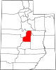
 Location of Sanpete County in Utah
This is a list of the National Register of Historic Places listings in Sanpete County, Utah.
This is intended to be a complete list of the properties and districts on the National Register of Historic Places in Sanpete County, Utah, United States. Latitude and longitude coordinates are provided for many National Register properties and districts; these locations may be seen together in a Google map.[1]
There are 74 properties and districts listed on the National Register in the county.
-
- This National Park Service list is complete through NPS recent listings posted November 10, 2011.[2]
Contents
Current listings
[3] Landmark name [4] Image Date listed Location City or town Summary 1 Claus P. Andersen House February 1, 1983 200 E. 200 South
39°21′22″N 111°35′35″W / 39.356111°N 111.593056°WEphraim 2 Lars S. Andersen House February 1, 1983 213 N. 200 East
39°21′49″N 111°34′53″W / 39.363611°N 111.581389°WEphraim 3 James Anderson House October 3, 1980 15 S. 200 East
39°37′40″N 111°26′03″W / 39.627778°N 111.434167°WFairview 4 Lewis and Clara Anderson House January 12, 1998 542 S. Main St.
39°15′27″N 111°38′12″W / 39.2575°N 111.636667°WManti 5 Niels Ole Anderson House October 5, 1978 306 S. 100 East
39°21′16″N 111°35′02″W / 39.354444°N 111.583889°WEphraim 6 Ole Arilsen House October 3, 1980 89 N. 300 East
39°32′51″N 111°26′57″W / 39.5475°N 111.449167°WMount Pleasant 7 Andrew Barentsen House February 1, 1983 195 W. 200 South
39°37′28″N 111°38′22″W / 39.624444°N 111.639444°WFountain Green 8 Anthony W. Bessey House October 22, 1980 415 N. 300 West
39°16′18″N 111°38′33″W / 39.271667°N 111.6425°WManti 9 Billings-Hougaard House October 14, 1980 75 E. 300 North
39°16′13″N 111°38′09″W / 39.270278°N 111.635833°WManti 10 Casino Theatre 
September 22, 1989 78 S. Main St.
39°09′15″N 111°49′04″W / 39.154167°N 111.817778°WGunnison 11 Centerfield School and Meetinghouse 
September 12, 2000 140 S. Main St.
39°07′25″N 111°49′08″W / 39.123611°N 111.818889°WCenterfield 12 Cox-Shoemaker-Parry House August 4, 1982 50 N. 100 West
39°15′59″N 111°38′16″W / 39.266389°N 111.637778°WManti 13 Charles Crawforth Farmstead February 19, 1980 Southwest of Spring City on Pigeon Hollow Rd.
39°27′16″N 111°30′43″W / 39.454444°N 111.511944°WSpring City 14 John Dorius, Jr. House 
May 9, 1985 46 W. 100 North
39°21′43″N 111°35′14″W / 39.361944°N 111.587222°WEphraim 15 Ephraim Carnegie Library October 25, 1984 30 S. Main St.
39°22′05″N 111°35′12″W / 39.368056°N 111.586667°WEphraim 16 Ephraim United Order Cooperative Building 
March 20, 1973 Main and 1st North Sts.
39°21′41″N 111°35′09″W / 39.361389°N 111.585833°WEphraim 17 Fairview Amusement Hall May 10, 2002 75 S. State St.
39°37′38″N 111°26′18″W / 39.627222°N 111.438333°WFairview 18 Fairview City Hall April 9, 1986 85 S. State St.
39°37′36″N 111°26′18″W / 39.626667°N 111.438333°WFairview 19 Fairview Tithing Office/Bishop's Storehouse 
January 25, 1985 60 W. 100 South
39°37′36″N 111°26′23″W / 39.626667°N 111.439722°WFairview 20 Jabez Faux House and Barn November 7, 1976 State Route 132
39°31′59″N 111°35′25″W / 39.533056°N 111.590278°WMoroni 21 Fountain Green Hydroelectric Plant Historic District April 20, 1989 Northwest of Fountain Green
39°38′11″N 111°40′19″W / 39.636389°N 111.671944°WFountain Green 22 Great Basin Research Station Historic District June 28, 1996 State Route 29, approximately 8 miles east of Ephraim in the Manti-Lasal National Forest Ephraim 23 Greaves-Deakin House October 3, 1980 118 S. Main St.
39°21′27″N 111°35′13″W / 39.3575°N 111.586944°WEphraim 24 Hans A. Hansen House 
October 22, 1980 75 W. 100 North
39°21′41″N 111°35′15″W / 39.361389°N 111.5875°WEphraim 25 Peter Hansen House February 1, 1983 247 S. 200 East
39°15′42″N 111°37′56″W / 39.261667°N 111.632222°WManti 26 Niels P. Hjort House October 3, 1980 26 S. State St.
39°37′40″N 111°26′20″W / 39.627778°N 111.438889°WFairview 27 Frederick C. Jensen House April 19, 1982 215 S. 100 West
39°32′37″N 111°27′22″W / 39.543611°N 111.456111°WMount Pleasant 28 Hans C. Jensen House February 1, 1983 263 E. 100 South
39°21′31″N 111°34′46″W / 39.358611°N 111.579444°WEphraim 29 Rasmus Jensen House February 1, 1983 97 E. 100 South
39°21′31″N 111°35′41″W / 39.358611°N 111.594722°WEphraim 30 Robert Johnson House October 14, 1980 103 E. 300 North
39°16′13″N 111°38′02″W / 39.270278°N 111.633889°WManti 31 Johnson-Nielson House 
July 26, 1982 351 N. Main St.
39°22′00″N 111°35′12″W / 39.366667°N 111.586667°WEphraim 32 Francis Marion Jolley House October 14, 1980 201 S. 200 East
39°15′45″N 111°37′56″W / 39.2625°N 111.632222°WManti 33 Oluf Larsen House February 1, 1983 75 S. 100 West
39°21′31″N 111°35′18″W / 39.358611°N 111.588333°WEphraim 34 Larsen-Noyes House 
December 1, 1978 96 E. Center St.
39°21′34″N 111°35′01″W / 39.359444°N 111.583611°WEphraim 35 John T. Lewellyn House October 3, 1980 15 N. State St.
39°29′09″N 111°38′05″W / 39.485833°N 111.634722°WWales 36 Manti Carnegie Library October 25, 1984 2 S. Main St.
39°15′55″N 111°37′59″W / 39.265278°N 111.633056°WManti 37 Manti City Hall June 27, 1985 191 N. Main St.
39°16′08″N 111°38′32″W / 39.268889°N 111.642222°WManti 38 Manti Motor Company Building May 7, 2008 87 N. Main St.
39°16′00″N 111°38′13″W / 39.26671°N 111.63703°WManti 39 Manti National Guard Armory April 9, 1986 50 E. 100 North
39°16′00″N 111°38′08″W / 39.266667°N 111.635556°WManti 40 Manti Presbyterian Church March 27, 1980 185 S. Main St.
39°15′42″N 111°38′08″W / 39.261667°N 111.635556°WManti 41 Manti Temple 
August 12, 1971 Northern edge of Manti, on U.S. Route 89
39°16′23″N 111°37′59″W / 39.273056°N 111.633056°WManti 42 James and Caroline M. Metcalf House 
July 23, 1998 290 E. 500 South
39°08′43″N 111°48′32″W / 39.145278°N 111.808889°WGunnison 43 Moroni High School Mechanical Arts Building April 1, 1985 350 N. Center St.
39°31′51″N 111°34′58″W / 39.530833°N 111.582778°WMoroni 44 Moroni Opera House May 23, 1996 325 W. Main St.
39°31′30″N 111°35′23″W / 39.525°N 111.589722°WMoroni 45 Mortensen-Nelson House July 10, 2003 291 E. 100 South
39°31′26″N 111°34′40″W / 39.523889°N 111.577778°WMoroni 46 Mount Pleasant Carnegie Library October 25, 1984 24 E. Main St.
39°32′48″N 111°27′14″W / 39.546667°N 111.453889°WMount Pleasant 47 Mount Pleasant Commercial Historic District 
October 26, 1979 U.S. Route 89 and State Route 116
39°32′46″N 111°27′22″W / 39.546111°N 111.456111°WMount Pleasant 48 Mount Pleasant High School Mechanical Arts Building April 1, 1985 150 N. State St.
39°32′58″N 111°27′13″W / 39.549444°N 111.453611°WMount Pleasant 49 Mount Pleasant National Guard Armory April 9, 1986 10 N. State St.
39°32′50″N 111°27′14″W / 39.547222°N 111.453889°WMount Pleasant 50 Jens Nielsen House February 1, 1983 192 W. 200 South
39°21′24″N 111°35′27″W / 39.356667°N 111.590833°WEphraim 51 John R. Nielson Cabin June 8, 2004 Manti Canyon
39°15′59″N 111°30′02″W / 39.266389°N 111.500556°WManti 52 N.S. Nielson House July 26, 1982 179 W. Main St.
39°32′47″N 111°27′29″W / 39.546389°N 111.458056°WMount Pleasant 53 Oberg-Metcalf House 
November 24, 1997 12 N. 100 East
39°09′19″N 111°49′05″W / 39.155278°N 111.818056°WGunnison 54 Hans Peter Olsen House April 22, 1976 215 S. State St.
39°37′36″N 111°38′00″W / 39.626667°N 111.633333°WFountain Green 55 Hans Ottesen House August 6, 1987 202 S. 200 West
39°15′45″N 111°38′25″W / 39.2625°N 111.640278°WManti 56 John Patten House August 22, 1977 95 W. 300 North
39°16′18″N 111°38′17″W / 39.271667°N 111.638056°WManti 57 Canute Peterson House 
July 17, 1978 10 N. Main St.
39°21′36″N 111°35′09″W / 39.36°N 111.585833°WEphraim 58 Poulson-Hall House April 27, 2011 90 S. 100 East
39°15′51″N 111°38′07″W / 39.264167°N 111.635278°WManti 59 Morten Rasmussen House August 18, 1977 417 W. Main St.
39°32′47″N 111°27′46″W / 39.546389°N 111.462778°WMount Pleasant 60 Sanpete County Courthouse April 1, 1985 160 N. Main St.
39°16′05″N 111°38′09″W / 39.268056°N 111.635833°WManti 61 William Stuart Seeley House July 16, 1992 150 S. State St.
39°32′41″N 111°27′18″W / 39.544722°N 111.455°WMount Pleasant 62 John H. Seely House March 9, 1982 91 S. 5th West
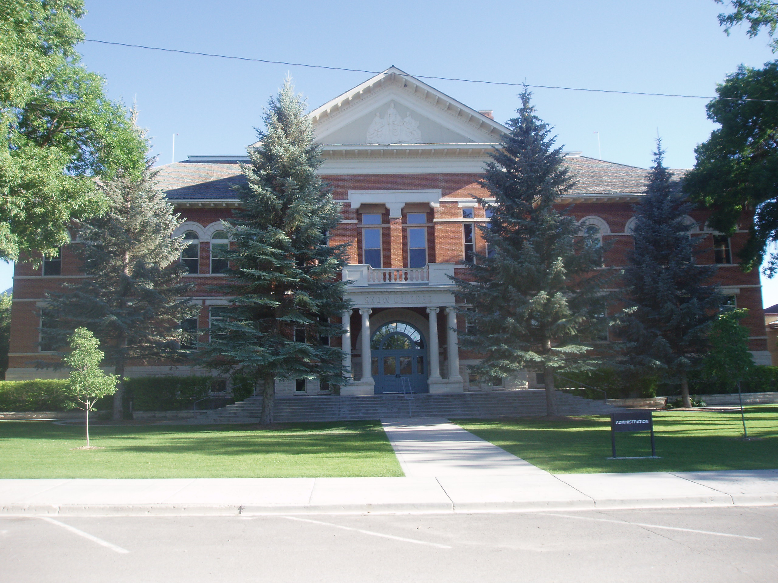
39°32′44″N 111°27′50″W / 39.545556°N 111.463889°WMount Pleasant 63 Snow Academy Building 
November 20, 1987 150 College Ave.
39°21′40″N 111°34′56″W / 39.361111°N 111.582222°WEphraim 64 Dykes Sorensen House October 20, 1982 302 S. 200 East
39°21′15″N 111°34′53″W / 39.354167°N 111.581389°WEphraim 65 Fredrick Christian Sorensen House 
October 14, 1980 62 E. Center St.
39°21′35″N 111°35′06″W / 39.359722°N 111.585°WEphraim 66 Spring City Historic District 
October 22, 1980 State Route 117
39°28′37″N 111°29′47″W / 39.476944°N 111.496389°WSpring City 67 Spring City School 
November 14, 1978 45 S. 100 East
39°28′40″N 111°29′35″W / 39.477778°N 111.493056°WSpring City 68 Alma Staker House July 9, 1979 81 E. 300 South
39°32′33″N 111°27′11″W / 39.5425°N 111.453056°WMount Pleasant 69 James B. Staker House October 3, 1980 U.S. Route 89
39°33′00″N 111°27′19″W / 39.55°N 111.455278°WMount Pleasant 70 Tuttle-Folsom House July 21, 1977 195 W. 300 North
39°16′11″N 111°38′23″W / 39.269722°N 111.639722°WManti 71 Wales Co-operative Mercantile Institution September 29, 2000 150 N. State St.
39°29′16″N 111°38′03″W / 39.487778°N 111.634167°WWales 72 Wasatch Academy 
October 2, 1978 200 S. 100 West
39°32′39″N 111°27′26″W / 39.544167°N 111.457222°WMount Pleasant 73 Watkins-Tholman-Larsen Farmstead December 27, 1996 422 E. 400 South St.
39°32′27″N 111°26′49″W / 39.540833°N 111.446944°WMount Pleasant 74 Cyrus Wheelock House October 3, 1980 200 E. 100 North
39°32′54″N 111°27′02″W / 39.548333°N 111.450556°WMount Pleasant See also
References
- ^ The latitude and longitude information provided in this table was derived originally from the National Register Information System, which has been found to be fairly accurate for about 99% of listings. For about 1% of NRIS original coordinates, experience has shown that one or both coordinates are typos or otherwise extremely far off; some corrections may have been made. A more subtle problem causes many locations to be off by up to 150 yards, depending on location in the country: most NRIS coordinates were derived from tracing out latitude and longitudes off of USGS topographical quadrant maps created under the North American Datum of 1927, which differs from the current, highly accurate WGS84 GPS system used by Google maps. Chicago is about right, but NRIS longitudes in Washington are higher by about 4.5 seconds, and are lower by about 2.0 seconds in Maine. Latitudes differ by about 1.0 second in Florida. Some locations in this table may have been corrected to current GPS standards.
- ^ "National Register of Historic Places: Weekly List Actions". National Park Service, United States Department of the Interior. Retrieved on November 10, 2011.
- ^ Numbers represent an ordering by significant words. Various colorings, defined here, differentiate National Historic Landmark sites and National Register of Historic Places Districts from other NRHP buildings, structures, sites or objects.
- ^ "National Register Information System". National Register of Historic Places. National Park Service. . http://nrhp.focus.nps.gov/natreg/docs/All_Data.html.
External links
 Media related to National Register of Historic Places in Sanpete County, Utah at Wikimedia Commons
Properties on the National Register of Historic Places in Utah 

U.S. National Register of Historic Places Topics Lists by states Alabama • Alaska • Arizona • Arkansas • California • Colorado • Connecticut • Delaware • Florida • Georgia • Hawaii • Idaho • Illinois • Indiana • Iowa • Kansas • Kentucky • Louisiana • Maine • Maryland • Massachusetts • Michigan • Minnesota • Mississippi • Missouri • Montana • Nebraska • Nevada • New Hampshire • New Jersey • New Mexico • New York • North Carolina • North Dakota • Ohio • Oklahoma • Oregon • Pennsylvania • Rhode Island • South Carolina • South Dakota • Tennessee • Texas • Utah • Vermont • Virginia • Washington • West Virginia • Wisconsin • WyomingLists by territories Lists by associated states Other Municipalities and communities of Sanpete County, Utah Cities Centerfield | Ephraim | Fairview | Fountain Green | Gunnison | Manti | Moroni | Mount Pleasant | Spring City
Towns Unincorporated
communitiesGhost towns Categories:- National Register of Historic Places in Utah by county
- Sanpete County, Utah
-


Wikimedia Foundation. 2010.