- National Register of Historic Places listings in Wasatch County, Utah
-
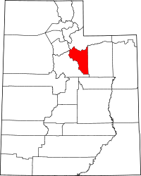 Location of Wasatch County in Utah
This is a list of the National Register of Historic Places listings in Wasatch County, Utah.
This is intended to be a complete list of the properties and districts on the National Register of Historic Places in Wasatch County, Utah, United States. Latitude and longitude coordinates are provided for many National Register properties and districts; these locations may be seen together in a Google map.[1]
There are 35 properties and districts listed on the National Register in the county.
-
- This National Park Service list is complete through NPS recent listings posted November 10, 2011.[2]
Contents
Current listings
[3] Landmark name[4] Image Date listed Location City or Town Summary 1 Austin-Wherritt House January 25, 1979 315 E. Center St.
40°30′28″N 111°24′25″W / 40.50778°N 111.40694°WHeber City 2 George Blackley House June 27, 1985 421 E. 200 North
40°30′38″N 111°24′19″W / 40.51056°N 111.40528°WHeber City 3 George Bonner, Jr. House June 17, 1986 90 E. Main St.
40°30′43″N 111°28′11″W / 40.51194°N 111.46972°WMidway 4 George Bonner, Sr. House June 17, 1986 103 E. Main St.
40°30′44″N 111°28′9″W / 40.51222°N 111.46917°WMidway 5 William Bonner House June 17, 1986 110 E. Main St.
40°30′43″N 111°28′9″W / 40.51194°N 111.46917°WMidway 6 Burgener-Boss Farmstead May 26, 1994 102 W. 100 North
40°30′51″N 111°28′32″W / 40.51417°N 111.47556°WMidway 7 Clotworthy-McMillan House February 12, 1999 261 S. Main St.
40°30′15″N 111°24′45″W / 40.50417°N 111.4125°WHeber City 8 James William Clyde House October 18, 1996 312 S. Main St.
40°30′12″N 111°24′47″W / 40.50333°N 111.41306°WHeber City 9 William Coleman House June 17, 1986 180 N. Center St.
40°30′57″N 111°28′16″W / 40.51583°N 111.47111°WMidway 10 Heber and Matilda Crook House and Lake Creek Schoolhouse 
April 17, 1995 4800 E. Lake Creek Rd.
40°30′0″N 111°19′35″W / 40.5°N 111.32639°WHeber City 11 John Crook House November 16, 1978 188 W. 3rd North
40°30′43″N 111°24′57″W / 40.51194°N 111.41583°WHeber City 12 David Fisher House April 16, 1980 125 E. 400 South
40°30′8″N 111°24′38″W / 40.50222°N 111.41056°WHeber City 13 Abram Hatch House 
October 10, 1975 81 E. Center St.
40°30′28″N 111°24′42″W / 40.50778°N 111.41167°WHeber City 14 Heber Second Ward Meetinghouse 
December 12, 1978 1st West and Center Sts.
40°30′26″N 111°24′51″W / 40.50722°N 111.41417°WHeber City 15 Lester F. and Margaret Stewart Hewlett Ranch House May 23, 1985 Off State Route 35
40°34′45″N 111°7′34″W / 40.57917°N 111.12611°WWoodland 16 John Huber House and Creamery August 11, 1988 Off Snake Creek Rd.
40°32′31″N 111°29′53″W / 40.54194°N 111.49806°WMidway 17 Midway Social Hall August 10, 1995 71 E. Main St.
40°30′45″N 111°28′13″W / 40.5125°N 111.47028°WMidway 18 Midway Town Hall December 1, 1994 120 W. Main St.
40°30′45″N 111°28′48″W / 40.5125°N 111.48°WMidway 19 John Murdoch House February 28, 1980 261 N. 400 West
40°30′40″N 111°25′12″W / 40.51111°N 111.42°WHeber City 20 Joseph S. Murdock House 
May 1, 1987 115 E. 300 North
40°30′42″N 111°24′38″W / 40.51167°N 111.41056°WHeber City 21 Schneitter Hotel December 17, 1992 700 N. Homestead Dr.
40°31′22″N 111°29′3″W / 40.52278°N 111.48417°WMidway 22 Snake Creek Hydroelectric Power Plant Historic District April 21, 1989 State Route 220
40°33′20″N 111°31′12″W / 40.55556°N 111.52°WMidway 23 Stewart Ranch Foreman's House May 23, 1985 Off State Route 35
40°33′28″N 111°8′6″W / 40.55778°N 111.135°WWoodland 24 Barnard J. Stewart Ranch House May 23, 1985 Off State Route 35
40°34′0″N 111°7′57″W / 40.566667°N 111.1325°WWoodland 25 Charles B. Stewart Ranch House May 23, 1985 Off State Route 35
40°34′48″N 111°7′32″W / 40.58°N 111.12556°WWoodland 26 Samuel W. Stewart Ranch House May 23, 1985 Off State Route 35
40°33′26″N 111°8′5″W / 40.55722°N 111.13472°WWoodland 27 Stewart-Hewlett Ranch Dairy Barn May 23, 1985 Off State Route 35
40°33′23″N 111°8′8″W / 40.55639°N 111.13556°WWoodland 28 Wasatch Saloon 
September 23, 1980 139 N. Main St.
40°30′34″N 111°24′47″W / 40.50944°N 111.41306°WHeber City 29 Wasatch Stake Tabernacle and Heber Amusement Hall 
December 2, 1970 Main St. at 100 North St. and 100 West St. corners
40°30′32″N 111°24′50″W / 40.50889°N 111.41389°WHeber City 30 Wasatch Wave Publishing Company Building December 27, 1979 55 W. Center St.
40°30′26″N 111°24′44″W / 40.50722°N 111.41222°WHeber City 31 John and Margaret Watkins House June 17, 1986 22 W. 100 South
40°30′39″N 111°28′21″W / 40.51083°N 111.4725°WMidway 32 Watkins-Coleman House 
May 14, 1971 5 E. Main St.
40°30′45″N 111°28′16″W / 40.5125°N 111.47111°WMidway 33 Ethelbert White and William M. Stewart Ranch House May 23, 1985 Off State Route 35
40°33′29″N 111°8′5″W / 40.55806°N 111.13472°WWoodland 34 Wilson House and Farmstead July 3, 2007 94 E. 250 North
40°31′5″N 111°28′14″W / 40.51806°N 111.47056°WMidway 35 Attewall Wootton, Jr. House April 10, 1980 270 E. Main St.
40°30′45″N 111°27′19″W / 40.5125°N 111.45528°WMidway Former listing
Landmark name Image Date delisted Location City or Town Summary 1 Cloud Rim Girl Scout Lodge February 1, 1995 Lake Brimhall
40°36′7″N 111°32′20″W / 40.60194°N 111.53889°WBrighton Originally listed April 9, 1986; destroyed by fire in November 1992; removed February 1, 1995;[5] rebuilt in 1999 See also
References
- ^ The latitude and longitude information provided in this table was derived originally from the National Register Information System, which has been found to be fairly accurate for about 99% of listings. For about 1% of NRIS original coordinates, experience has shown that one or both coordinates are typos or otherwise extremely far off; some corrections may have been made. A more subtle problem causes many locations to be off by up to 150 yards, depending on location in the country: most NRIS coordinates were derived from tracing out latitude and longitudes off of USGS topographical quadrant maps created under the North American Datum of 1927, which differs from the current, highly accurate WGS84 GPS system used by Google maps. Chicago is about right, but NRIS longitudes in Washington are higher by about 4.5 seconds, and are lower by about 2.0 seconds in Maine. Latitudes differ by about 1.0 second in Florida. Some locations in this table may have been corrected to current GPS standards.
- ^ "National Register of Historic Places: Weekly List Actions". National Park Service, United States Department of the Interior. Retrieved on November 10, 2011.
- ^ Numbers represent an ordering by significant words. Various colorings, defined here, differentiate National Historic Landmark sites and National Register of Historic Places Districts from other NRHP buildings, structures, sites or objects.
- ^ "National Register Information System". National Register of Historic Places. National Park Service. 2008-04-24. http://nrhp.focus.nps.gov/natreg/docs/All_Data.html.
- ^ "National Register of Historic Places Weekly Action Lists: 1995". U.S. National Park Service. http://www.nps.gov/nr/listings/Weekly_Register_List_1995.pdf. Retrieved April 28, 2011.
External links
 Media related to National Register of Historic Places in Wasatch County, Utah at Wikimedia Commons
Properties on the National Register of Historic Places in Utah 

U.S. National Register of Historic Places Topics Lists by states Alabama • Alaska • Arizona • Arkansas • California • Colorado • Connecticut • Delaware • Florida • Georgia • Hawaii • Idaho • Illinois • Indiana • Iowa • Kansas • Kentucky • Louisiana • Maine • Maryland • Massachusetts • Michigan • Minnesota • Mississippi • Missouri • Montana • Nebraska • Nevada • New Hampshire • New Jersey • New Mexico • New York • North Carolina • North Dakota • Ohio • Oklahoma • Oregon • Pennsylvania • Rhode Island • South Carolina • South Dakota • Tennessee • Texas • Utah • Vermont • Virginia • Washington • West Virginia • Wisconsin • WyomingLists by territories Lists by associated states Other Municipalities and communities of Wasatch County, Utah Cities 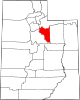
Towns Charleston | Daniel | Hideout | Independence | Wallsburg
CDP Indian
reservationGhost towns Hailstone | Keetley | Soldier Summit
Categories:- National Register of Historic Places in Utah by county
- Wasatch County, Utah
-


Wikimedia Foundation. 2010.