- National Register of Historic Places listings in Kane County, Utah
-
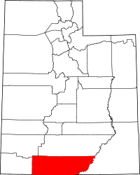 Location of Kane County in Utah
This is a list of the National Register of Historic Places listings in Kane County, Utah.
This is intended to be a complete list of the properties and districts on the National Register of Historic Places in Kane County, Utah, United States. Latitude and longitude coordinates are provided for many National Register properties and districts; these locations may be seen together in a Google map.[1]
There are 16 properties listed on the National Register in the county.
-
- This National Park Service list is complete through NPS recent listings posted November 10, 2011.[2]
Contents
Current listings
[3] Landmark name [4] Image Date listed Location City or town Summary 1 Bowman-Chamberlain House July 8, 1975 14 E. 100 South
37°02′47″N 112°31′37″W / 37.046389°N 112.526944°WKanab 2 Cottonwood Canyon Cliff Dwelling 
August 18, 1980 Address Restricted[5] Kanab 3 Davis Gulch Pictograph Panel June 5, 1975 Address Restricted[5] Glen Canyon 4 Maynard and Edith Hamlin Dixon House and Studio 
January 11, 2002 State Route 89
37°15′13″N 112°39′37″W / 37.253611°N 112.660278°WMt. Carmel Junction 5 Hole-In-The-Rock 
November 3, 1975 Southeast of Escalante in Glen Canyon National Recreation Area
37°15′31″N 110°54′00″W / 37.258611°N 110.9°WEscalante 6 Hole-in-the-Rock Trail 
August 9, 1982 A trail commencing at Escalante and terminating at Bluff
37°25′18″N 110°39′51″W / 37.421667°N 110.664167°WEscalante Split between Garfield, Kane, and San Juan counties 7 William Derby Johnson, Jr., House April 6, 2001 54 S. Main St.
37°02′49″N 112°31′42″W / 37.046944°N 112.528333°WKanab 8 Kanab (Union Pacific) Lodge August 14, 2003 86 S. 200 West
37°02′48″N 112°31′57″W / 37.046667°N 112.5325°WKanab 9 Kanab Hotel and Cafe August 14, 2003 19 W. Center St.
37°02′52″N 112°31′42″W / 37.047778°N 112.528333°WKanab 10 Kanab Library September 7, 1995 600 S. 100 East
37°02′55″N 112°31′15″W / 37.048611°N 112.520833°WKanab 11 Kanab Post Office January 24, 2011 22 N. Main St.
37°02′55″N 112°31′43″W / 37.048611°N 112.528611°WKanab Kanab, Utah MPS 12 Mt. Carmel School and Church 
November 20, 1987 Off State Route 89
37°14′48″N 112°39′55″W / 37.246667°N 112.665278°WMt. Carmel Junction 13 Parry Lodge August 14, 2003 89 E. Center St.
37°02′54″N 112°31′34″W / 37.048333°N 112.526111°WKanab 14 Rider-Pugh House April 6, 2001 17 W. 100 South
37°02′49″N 112°31′42″W / 37.046944°N 112.528333°WKanab 15 Stewart-Woolley House April 6, 2001 106 W. 100 North
37°03′00″N 112°31′49″W / 37.05°N 112.530278°WKanab 16 Valley School April 1, 1985 150 N. Main St.
37°16′45″N 112°38′18″W / 37.279167°N 112.638333°WOrderville See also
References
- ^ The latitude and longitude information provided in this table was derived originally from the National Register Information System, which has been found to be fairly accurate for about 99% of listings. For about 1% of NRIS original coordinates, experience has shown that one or both coordinates are typos or otherwise extremely far off; some corrections may have been made. A more subtle problem causes many locations to be off by up to 150 yards, depending on location in the country: most NRIS coordinates were derived from tracing out latitude and longitudes off of USGS topographical quadrant maps created under the North American Datum of 1927, which differs from the current, highly accurate WGS84 GPS system used by Google maps. Chicago is about right, but NRIS longitudes in Washington are higher by about 4.5 seconds, and are lower by about 2.0 seconds in Maine. Latitudes differ by about 1.0 second in Florida. Some locations in this table may have been corrected to current GPS standards.
- ^ "National Register of Historic Places: Weekly List Actions". National Park Service, United States Department of the Interior. Retrieved on November 10, 2011.
- ^ Numbers represent an ordering by significant words. Various colorings, defined here, differentiate National Historic Landmark sites and National Register of Historic Places Districts from other NRHP buildings, structures, sites or objects.
- ^ "National Register Information System". National Register of Historic Places. National Park Service. . http://nrhp.focus.nps.gov/natreg/docs/All_Data.html.
- ^ a b Some listings on the NRHP are highly sensitive sites and may be subject to looting or vandalism. The NRHP lists this site as "Address Restricted."
External links
 Media related to National Register of Historic Places in Kane County, Utah at Wikimedia Commons
Properties on the National Register of Historic Places in Utah 

U.S. National Register of Historic Places Topics Lists by states Alabama • Alaska • Arizona • Arkansas • California • Colorado • Connecticut • Delaware • Florida • Georgia • Hawaii • Idaho • Illinois • Indiana • Iowa • Kansas • Kentucky • Louisiana • Maine • Maryland • Massachusetts • Michigan • Minnesota • Mississippi • Missouri • Montana • Nebraska • Nevada • New Hampshire • New Jersey • New Mexico • New York • North Carolina • North Dakota • Ohio • Oklahoma • Oregon • Pennsylvania • Rhode Island • South Carolina • South Dakota • Tennessee • Texas • Utah • Vermont • Virginia • Washington • West Virginia • Wisconsin • WyomingLists by territories Lists by associated states Other Municipalities and communities of Kane County, Utah City 
Towns Alton | Big Water | Glendale | Orderville
Unincorporated
communitiesGhost town Categories:- National Register of Historic Places in Utah by county
- Kane County, Utah
-


Wikimedia Foundation. 2010.