- National Register of Historic Places listings in Sevier County, Utah
-
 Location of Sevier County in Utah
This is a list of the National Register of Historic Places listings in Sevier County, Utah.
This is intended to be a complete list of the properties and districts on the National Register of Historic Places in Sevier County, Utah, United States. Latitude and longitude coordinates are provided for many National Register properties and districts; these locations may be seen together in a Google map.[1]
There are 23 properties and districts listed on the National Register in the county.
-
- This National Park Service list is complete through NPS recent listings posted November 10, 2011.[2]
Current listings
[3] Landmark name [4] Image Date listed Location City or town Summary 1 Aspen-Cloud Rock Shelters 
November 1, 1979 Address Restricted,[5] in Saleratus Canyon on Old Woman Plateau Salina Archaic rock shelters that include archaeological remains of the earliest houses found in Utah. 2 Elsinore Sugar Factory 
June 17, 1980 East of Elsinore
38°40′53″N 112°07′24″W / 38.681389°N 112.123333°WElsinore 3 Elsinore White Rock Schoolhouse 
January 18, 1978 15 E. 200 North
38°41′10″N 112°08′50″W / 38.686111°N 112.147222°WElsinore 4 Glenwood Cooperative Store 
April 29, 1980 15 W. Center St.
38°45′47″N 111°59′23″W / 38.763056°N 111.989722°WGlenwood 5 Gooseberry Valley Archeological District September 4, 1980 Address Restricted,[5] southeast of Salina in Fishlake National Forest Salina Collection of archaeological sites left by the Fremont culture 6 Jens Larson Jenson Lime Kiln 
December 22, 1978 2 miles north of Richfield
38°47′36″N 112°05′08″W / 38.793333°N 112.085556°WRichfield 7 Martin Johnson House 
October 20, 1982 45 W. 400 South
38°45′27″N 111°59′25″W / 38.7575°N 111.990278°WGlenwood 8 Monroe City Hall 
April 1, 1985 10 N. Main St.
38°37′58″N 112°07′15″W / 38.632778°N 112.120833°WMonroe 9 Monroe Presbyterian Church 
March 27, 1980 20 W. 100 North
38°38′02″N 112°07′16″W / 38.633889°N 112.121111°WMonroe 10 Joseph William Parker Farm 
March 25, 1977 2.5 miles northeast of Joseph
38°39′18″N 112°11′39″W / 38.655°N 112.194167°WJoseph 11 Peterson-Burr House 
February 18, 1994 190 W. Main
38°57′28″N 111°51′43″W / 38.957778°N 111.861944°WSalina 12 Redmond Hotel 
June 20, 1980 15 E. Main St.
39°00′22″N 111°51′48″W / 39.006111°N 111.863333°WRedmond 13 Redmond Town Hall 
September 13, 1976 18 W. Main St.
39°00′22″N 111°51′50″W / 39.006111°N 111.863889°WRedmond 14 Richfield Carnegie Library 
October 25, 1984 83 E. Center St.
38°46′06″N 112°04′57″W / 38.768333°N 112.0825°WRichfield 15 Salina Hospital 
June 19, 1980 330 W. Main St.
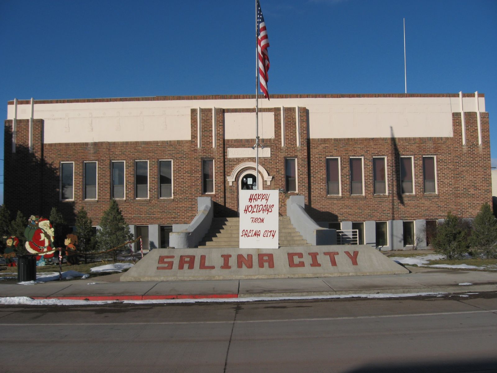
38°57′28″N 111°51′54″W / 38.957778°N 111.865°WSalina 16 Salina Municipal Building and Library 
April 9, 1986 90 W. Main
38°57′28″N 111°51′38″W / 38.957778°N 111.860556°WSalina 17 Salina Presbyterian Church 
March 27, 1980 204 S. 1st East
38°57′17″N 111°51′27″W / 38.954722°N 111.8575°WSalina 18 Sevier Ward Church 
June 24, 1980 East of Sevier along U.S. Route 89
38°35′43″N 112°14′58″W / 38.595278°N 112.249444°WSevier 19 Soren Simonsen House 
October 20, 1982 55 W. 200 North
38°38′06″N 112°07′19″W / 38.635°N 112.121944°WMonroe 20 Sudden Shelter (42SV6) January 4, 1989 Address Restricted[5] Salina A cave that has yielded projectile points from a range of archaeological periods 21 US Post Office-Richfield Main 
November 27, 1989 93 N. Main
38°46′09″N 112°05′04″W / 38.769167°N 112.084444°WRichfield 22 Joseph Wall Gristmill 
June 20, 1980 355 S. 250 East
38°45′30″N 111°59′05″W / 38.758333°N 111.984722°WGlenwood 23 Young Block 
June 24, 1980 3-17 S. Main St.
38°46′04″N 112°05′01″W / 38.767778°N 112.083611°WRichfield Former listing
[3] Landmark name Image Date listed Location City or town Summary 1 Ralph Ramsay House September 3, 2009 57 E. 2nd North
38°46′16″N 112°4′59″W / 38.77111°N 112.08306°WRichfield Originally listed July 8, 1975; removed September 3, 2009[6] See also
References
- ^ The latitude and longitude information provided in this table was derived originally from the National Register Information System, which has been found to be fairly accurate for about 99% of listings. For about 1% of NRIS original coordinates, experience has shown that one or both coordinates are typos or otherwise extremely far off; some corrections may have been made. A more subtle problem causes many locations to be off by up to 150 yards, depending on location in the country: most NRIS coordinates were derived from tracing out latitude and longitudes off of USGS topographical quadrant maps created under the North American Datum of 1927, which differs from the current, highly accurate WGS84 GPS system used by Google maps. Chicago is about right, but NRIS longitudes in Washington are higher by about 4.5 seconds, and are lower by about 2.0 seconds in Maine. Latitudes differ by about 1.0 second in Florida. Some locations in this table may have been corrected to current GPS standards.
- ^ "National Register of Historic Places: Weekly List Actions". National Park Service, United States Department of the Interior. Retrieved on November 10, 2011.
- ^ a b Numbers represent an ordering by significant words. Various colorings, defined here, differentiate National Historic Landmark sites and National Register of Historic Places Districts from other NRHP buildings, structures, sites or objects.
- ^ "National Register Information System". National Register of Historic Places. National Park Service. . http://nrhp.focus.nps.gov/natreg/docs/All_Data.html.
- ^ a b c Some listings on the NRHP are highly sensitive sites and may be subject to looting or vandalism. The NRHP lists this site as "Address Restricted."
- ^ "National Register of Historic Places Listings: September 11, 2009". U.S. National Park Service. http://www.nps.gov/history/nr/listings/20090911.htm. Retrieved September 29, 2009.
External links
 Media related to National Register of Historic Places in Sevier County, Utah at Wikimedia Commons
Properties on the National Register of Historic Places in Utah 

U.S. National Register of Historic Places Topics Lists by states Alabama • Alaska • Arizona • Arkansas • California • Colorado • Connecticut • Delaware • Florida • Georgia • Hawaii • Idaho • Illinois • Indiana • Iowa • Kansas • Kentucky • Louisiana • Maine • Maryland • Massachusetts • Michigan • Minnesota • Mississippi • Missouri • Montana • Nebraska • Nevada • New Hampshire • New Jersey • New Mexico • New York • North Carolina • North Dakota • Ohio • Oklahoma • Oregon • Pennsylvania • Rhode Island • South Carolina • South Dakota • Tennessee • Texas • Utah • Vermont • Virginia • Washington • West Virginia • Wisconsin • WyomingLists by territories Lists by associated states Other Municipalities and communities of Sevier County, Utah Cities 
Towns Unincorporated
communityCategories:- National Register of Historic Places in Utah by county
- Sevier County, Utah
-


Wikimedia Foundation. 2010.