- Munjor, Kansas
-
Munjor, Kansas — Unincorporated community — 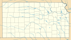
 Munjor, Kansas
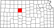
Coordinates: 38°48′40″N 99°15′53″W / 38.81111°N 99.26472°WCoordinates: 38°48′40″N 99°15′53″W / 38.81111°N 99.26472°W Country United States State Kansas County Ellis Founded 1876 Elevation 1,946 ft (593 m) Population (2010)[1] – Total 213 Time zone Central (CST) (UTC-6) – Summer (DST) CDT (UTC-5) ZIP code 67601 Area code(s) 785 GNIS feature ID 475292[2] Munjor is an unincorporated community and census-designated place (CDP) in Wheatland Township, Ellis County, Kansas, United States. As of the 2010 census, the population of the community was 213.[1]
Contents
Geography
Munjor is located at 38°48′40″N 99°15′53″W / 38.81111°N 99.26472°W (38.8111231, -99.2648236) at an elevation of 1,946 feet (593 m).[2] It lies on the southwest side of Big Creek, a tributary of the Smoky Hill River, in the Smoky Hills region of the Great Plains.[3][4] Munjor is roughly 4.5 miles (7 km) south of Interstate 70, 3 miles (5 km) east of U.S. Route 183, and 5 miles (8 km) southeast of Hays, the county seat.[4]
Demographics
As of the 2010 census, there were 213 people, 99 households, and 66 families residing in the community. There were 112 housing units. The racial makeup of the community was 98.1% White and 1.9% from some other race. Hispanics or Latinos of any race were 2.3% of the population.[1]
There were 99 households out of which 21.2% had children under the age of 18 living with them, 49.5% were married couples living together, 7.1% had a male householder with no wife present, 10.1% had a female householder with no husband present, and 33.3% were non-families. 28.3% of all households were made up of individuals, and 8.0% had someone living alone who was 65 years of age or older. The average household size was 2.15, and the average family size was 2.59.[1]
In the community, the population was spread out with 17.4% under the age of 18, 7.3% from 18 to 24, 22.1% from 25 to 44, 33.5% from 45 to 64, and 19.7% who were 65 years of age or older. The median age was 46.8 years. For every 100 females, there were 100.1 males. For every 100 females age 18 and over, there were 112.1 males age 18 and over.[1]
Education
Munjor lies within Unified School District (USD) 489, based in Hays.[5][6]
References
- ^ a b c d e "American FactFinder 2". United States Census Bureau. http://factfinder2.census.gov/faces/nav/jsf/pages/index.xhtml. Retrieved 2011-09-16.
- ^ a b "US Board on Geographic Names". United States Geological Survey. 2007-10-25. http://geonames.usgs.gov. Retrieved 2008-01-31.
- ^ "2003-2004 Official Transportation Map". Kansas Department of Transportation. 2003. http://www.ksdot.org/burtransplan/maps/HistoricStateMaps/2003-04Mapside.pdf. Retrieved 2011-09-16.
- ^ a b "General Highway Map - Ellis County, Kansas". Kansas Department of Transportation. 2010-06-01. http://www.ksdot.org/burtransplan/maps/county-pdf/ellis.PDF. Retrieved 2011-09-16.
- ^ "City of Hays / Ellis County Geospatial Data Portal". City of Hays / Ellis County - GIS Division. http://www.geodataportal.net/webmapping.html. Retrieved 2011-09-16.
- ^ "USD 489". USD 489. http://www.hays489.k12.ks.us/. Retrieved 2011-09-16.
External links
- Schools
- Hays USD 489, local school district
- Maps
- Ellis County Map, KDOT
Municipalities and communities of Ellis County, Kansas Cities Ellis | Hays | Schoenchen | Victoria
Townships Unincorporated
communitiesAntonino | Catharine | Emmeram | Munjor | Pfeifer | Toulon | Walker | Yocemento
Ghost towns Categories:- Populated places in Ellis County, Kansas
- Unincorporated communities in Kansas


Wikimedia Foundation. 2010.