- Ohio and Erie Canal
-
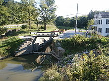
Ohio and Erie Canal Historic District
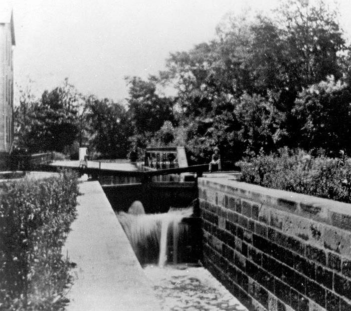
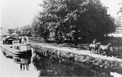 The Ohio and Erie canal in 1902
Location: Independence and
Valley View,
Cuyahoga County, OhioArea: 24.5 acres (99,000 m2)[1] Built: 1825 Architect: Unknown Architectural style: No Style Listed Governing body: National Park Service NRHP Reference#: 66000607 Significant dates Added to NRHP: November 13, 1966[2] Designated NHLD: November 13, 1966[3] The Ohio Canal[4] or Ohio and Erie Canal was a canal constructed in the 1820s and early 1830s. It connected Akron, Summit County, with the Cuyahoga River near its mouth on Lake Erie in Cleveland, Cuyahoga County, and a few years later, with the Ohio River near Portsmouth, Scioto County, and then connections to other canal systems in Pennsylvania and Ohio.
The canal carried freight traffic from 1827 to 1861, when the arrival of railroads killed the market. From 1862 to 1913, the canal served as a water source to industries and towns. In 1913, much of the canal system was abandoned after critical sections were destroyed by flooding.
Today, most of the remaining portions are managed by the National Park Service or Ohio Department of Natural Resources. They are used for various recreational purposes by the public, and still provide water for some industries. Parts of the canal are preserved, including the Ohio and Erie Canal Historic District, a U.S. National Historic Landmark.
Contents
History
Ohio, which achieved statehood in 1803, remained a sparsely populated state of 50,000 persons, scattered and with no economical means of transportation of goods. With no access to markets, agriculture served only local needs and manufacturing was nearly non-existing.[5]
Agitation for a canal system (1787-1822)
As early as 1787, George Washington and Thomas Jefferson had discussed the desirability of a canal linking Lake Erie to the Ohio River as part of a national system of canals.[6] It wasn't until 1807 that Ohio's first Senator, Thomas Worthington offered a resolution in Congress asking Treasury Secretary Albert Gallatin to report to the Senate. In 1810, DeWitt Clinton was appointed to head the Erie Canal Commission. He was unsuccessful in his attempt to get national aid for the construction of a canal connecting Lake Erie to the Hudson River, so he enlisted the aid of Ohio (and its congressional delegation). On January 15, 1812 the Ohio General Assembly passed a resolution indicating that the connection of the Great Lakes with the Hudson River was a project of "national concern". President Madison was against the proposal, however, and the War of 1812 ended all discussion.
On December 11, 1816, Clinton, now Governor of New York, sent a letter to the Ohio Legislature indicating his state's willingness to construct the Erie Canal without national help, and asking the State of Ohio to join in the endeavor. On January 9, 1817, the Ohio Legislature directed Ohio's Governor, the same Thomas Worthington, to negotiate a deal with Clinton. Due to the cost, however, the Ohio Legislature dallied, and nothing happened for the next 3 years. Finally, in January 1822, in a fit of progressivism, the Ohio Legislature passed acts to fund the canal system and the state's public education obligations.
Survey and design (1822)
On January 31, 1822 the Ohio Legislature passed a resolution to employ an engineer and appoint commissioners to survey and design the canal system as soon as possible. A sum not to exceed $6000 was set aside for this purpose.
James Geddes, an engineer experienced from work on the New York canals, was employed. Since most of Ohio's population lived along a line from Cleveland to Cincinnati, it was necessary that these areas be served by the main trunk of the canal. Since canals must generally follow river valleys, it was difficult to design a suitable system. Specifically, the bridging of the Scioto and Miami river valleys required raising the canal to such an elevation that water from neither river could be used as a source. As a result, the canal was divided into two sections, the Ohio and Erie Canal from Cleveland to Portsmouth which crossed the Licking Divide and followed the Scioto River Valley, and the Miami and Erie Canal which connected Cincinnati to Dayton. In later years this second canal would be extended all the way to the Maumee River at Toledo.
Copies of the original survey plat maps for the construction of both Ohio canals are available on-line[7] from the Ohio Department of Natural Resources.
Construction (1825-1832)
On February 4, 1825, the Ohio Legislature passed "An Act to provide for the Internal Improvement of the State of Ohio by Navigable Canals". The Canal Commission was authorized to borrow $400,000 in 1825, and not more than $600,000 per year thereafter. The notes issued were to be redeemable between 1850 and 1875.
On July 4, 1825, ground was broken on the canal at Licking Summit near Newark, Ohio.
The canals were specified to have a minimum width of 40 feet (12 m) at the top, 26 feet (8 m) at the bottom, and a depth of 4 feet (1.2 m) feet minimum. These limits were often exceeded, and indeed it was cheaper to do so in most cases. For example, it might be cheaper to build one embankment and then let the water fill all the way to the adjacent foothills, perhaps hundreds of feet away, rather than build two embankments. By damming the rivers, long stretches of slackwater could be created which, with the addition of towpaths, could serve as portions of the canal. Where it made economic sense to do so, such as lock widths or portions of the canal through narrow rock or across aqueducts, the minimum widths were adhered to.[citation needed]
Contracts were let for the following tasks:
- Grubbing and clearing
- Mucking and ditching
- Embankment and excavation
- Locks and culverts
- Puddling
- Protection
Initially, contractors in general proved to be inexperienced and unreliable. It was common for one job to receive 50 bids, many of them local to where the work was being performed. The chosen contractor, having underbid the contract, often would vanish in the night leaving his labor force unpaid and his contract unfulfilled. This problem was so bad that laborers refused to perform canal work for fear of not being paid. As the bidding process was improved, and more reliable contractors engaged, the situation improved.[citation needed]
Workers were initially paid $0.30 per day and offered a jigger of whiskey. As work progressed, and where labor was in shortage, workers could make as much as $15 per month. At that time, cash money was hard to come by in Ohio forcing much bartering. Working on the canal was appealing and attracted many farmers from their land.[citation needed]
On July 3, 1827 the first canal boat on the Ohio and Erie Canal left Akron, traveled through 41 locks and over 3 aqueducts along 37 miles (60 km) of canal, to arrive at Cleveland on July 4. While the average speed of 3 mph (4.8 km/h) seems slow, canal boats could carry 10 tons of goods and were much more efficient than wagons over rutted trails.
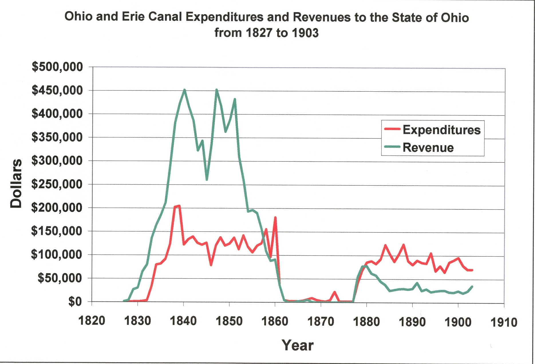
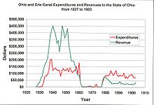 Graph showing the annual expenditures and revenues accrued to the State of Ohio by the Ohio and Erie Canal from 1827 to 1903.
Over the next five years, more and more portions of the canal opened, with it finally being completed in 1832:
- 1828 opens from Akron to Massillon, Ohio. The canal is 65 miles (105 km) long.
- 1829 opens from Massillon to Dover, Ohio. The canal is 93 miles (150 km) long.
- 1830 opens from Dover to Newark, Ohio. The canal is 177 miles (285 km) long.
- 1831 opens from Newark to Chillicothe, Ohio. The canal is 258 miles (415 km) long.
In 1832, the Ohio and Erie Canal was completed. The entire canal system was 308 miles (496 km) long with 146 lift locks and a rise of 1,206 feet (368 m). In addition, there were five feeder canals that added 24.8 miles (39.9 km) and 6 additional locks to the system consisting of:
- Tuscarawas Feeder (3.2 miles)
- Walhonding Feeder (1.3 miles)
- Granville Feeder (6.1 miles)
- Muskinghum Side Cut (2.6 miles)
- Columbus Feeder (11.6 miles)
The canal's lock numbering system was oriented from the Lower Basin, near the southwest corner of the current Exchange and Main streets in Akron. North of the basin is Lock 1 North, and south of the basin is Lock 1 South. At this basin was the joining of the Pennsylvania and Ohio Canal.[8][9]
Operation (1833 - 1913)
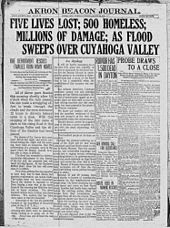 The Akron Beacon Journal front page on March 25, 1913; two days after the flood
The canals enjoyed a golden period of prosperity from the 1830s to the early 1860s, with a peak in revenue between 1852 and 1855. During the 1840s, Ohio was the third most prosperous state, owing much of that growth to the canal.[10] Immediately following the Civil War, it became apparent that railroads would take the canal's business. From 1861 until 1879, after the canal had been badly flooded,[10] Ohio leased its canals to private owners who earned revenue from dwindling boat operation and the sale of water to factories and towns. When the state took the canals back in 1879, it discovered that they had not been maintained, and that state lands surrounding the canals had been illegally sold to private owners. In many cases, canals were filled in for "health reasons", only to find a newly laid railroad track on their right of way. Much State land was given away for free to politically savvy private owners. Nevertheless, some revenue was accrued into the early twentieth century from the sale of water rights as well as recovery and sale of land surrounding the canals.
Abandonment
After the peak of the 1850s and a bottoming out of revenue due to the Civil War in the early 1860s the canal's expenditures starting to outgrow its revenues due to rising maintenance costs. By 1911, most of the southern portion of the canal had been abandoned.[10] On March 23, 1913, after a winter of record snowfall, storms dumped an abnormally heavy amount of rain on the state, causing extensive flooding. This caused the reservoirs to spill over into the canals, destroying aqueducts, washing out banks, and devastating most of the locks. In Akron, Lock 1 was dynamited to allow backed up floodwater to flow.[11]
Notable persons associated with the Canal
- As a teenager in 1847, James Garfield worked as a Hoggee, driving mules to pull barges along the canal.[12] After repeatedly falling into the canal on the job, Garfield became ill, and decided to go to college instead.[13]
The Canal today
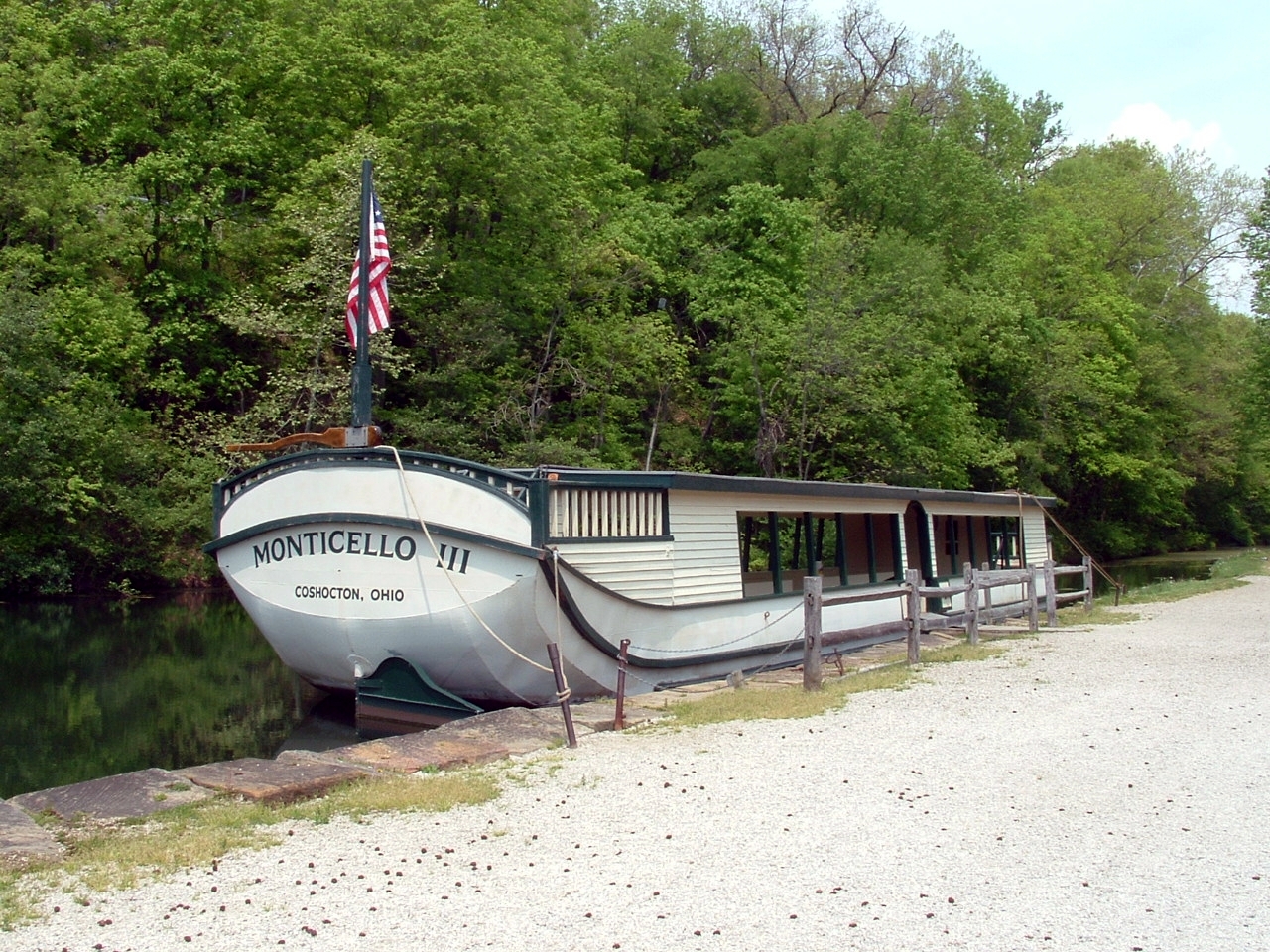
 Restored canal boat
The Ohio and Erie Canal Historic District, a 24.5-acre (99,000 m2) historic district including part of the canal, was declared a National Historic Landmark in 1966.[1][3] It is a four mile (6 km) section within the township of Valley View, Ohio that contains three locks, the Tinkers Creek Aqueduct and two structures.[1]
A remaining watered section of the Ohio & Erie Canal is located in Summit County, Ohio. The Ohio & Erie Canal is maintained, to this day, as a water supply for local industries. After the flood, a few sections of the canal continued in use hauling cargo to local industries. Another watered section extends from the Station Road Bridge in Brecksville northwards into Valley View and Independence, all Cleveland suburbs.
The section of the Ohio & Erie Canal from the Brecksville Dam to Rockside Road in Cuyahoga County was transferred to the National Park Service in 1989 as part of the Cuyahoga Valley National Recreational Area (now known as the Cuyahoga Valley National Park).
A lease on the canal lands from the Cuyahoga Valley National Park to the terminus of the canal has been executed with the Cleveland Metroparks. The Metroparks manage the adjacent real estate and the surrounding Ohio & Erie Canal Reservation.
The section of the Ohio & Erie Canal still owned and maintained by the Division of Water in southern Summit is referred to as the watered section. This section runs from the north end of Summit Lake south to Barberton, a distance of about 12 miles (19 km). Included in this section is the feeder canal from the Tuscarawas River and the hydraulics at the Portage Lakes.
The Ohio & Erie Canal is maintained from Akron by a staff of six Division of Water employees. Like its sister canal, the Ohio & Erie Canal carries a large amount of stormwater. The canals were not designed to accommodate this great influx of stormwater. Most of the siltation and erosion problems experienced today are the result of stormwater inappropriately piped into the canals over the years.
In late 1996, the canal from Zoar to Cleveland was designated a National Heritage Corridor. This designation was brought about through the efforts of many communities, civic organizations, businesses and individuals working in partnership. The Department is working with numerous local communities and organizations to assure the continued development of the Ohio & Erie Canal.
A map showing the disposition of the canal lands[14] is available on-line from the Ohio Department of Natural Resources.
Points of interest
 Towpath through Akron
- Alexander's (a.k.a. Wilson's) Mill
- Richard Howe House (future site)
- Boston Store
- Canal Visitor Center
- Frazee House
- Mustill Store
- Peninsula Depot
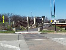
- Station Road Bridge
- Tinkers Creek Aqueduct
Connecting canals
The Ohio and Erie Canal initially provided a connection between Akron and Lake Erie at Cleveland, then extending all the way to the Ohio River within a few years. Later, connecting canal systems were built connecting it with the Pennsylvania and Ohio Canal and other parts of Eastern Ohio.[15]
Towpath Trail landmarks
An all-purpose bicycle/pedestrian trail was constructed by Cuyahoga Valley National Park in Southern Cuyahoga County and Northern Summit County, Cleveland Metroparks in Northern Cuyahoga County, and Akron/Summit County Metroparks in Southern Summit County to roughly follow the original Ohio and Erie Canal Towpath route.[20] (The Northernmost section in Cuyahoga County is still undergoing construction.) There are many connecting trails going to other points of interest throughout their park systems.
Please help by expanding this section with any notable landmarks along the Ohio and Erie Canal Towpath Trail.
 Restored canal Twelve Mile Lock 38, Cuyahoga Valley National Park
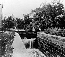
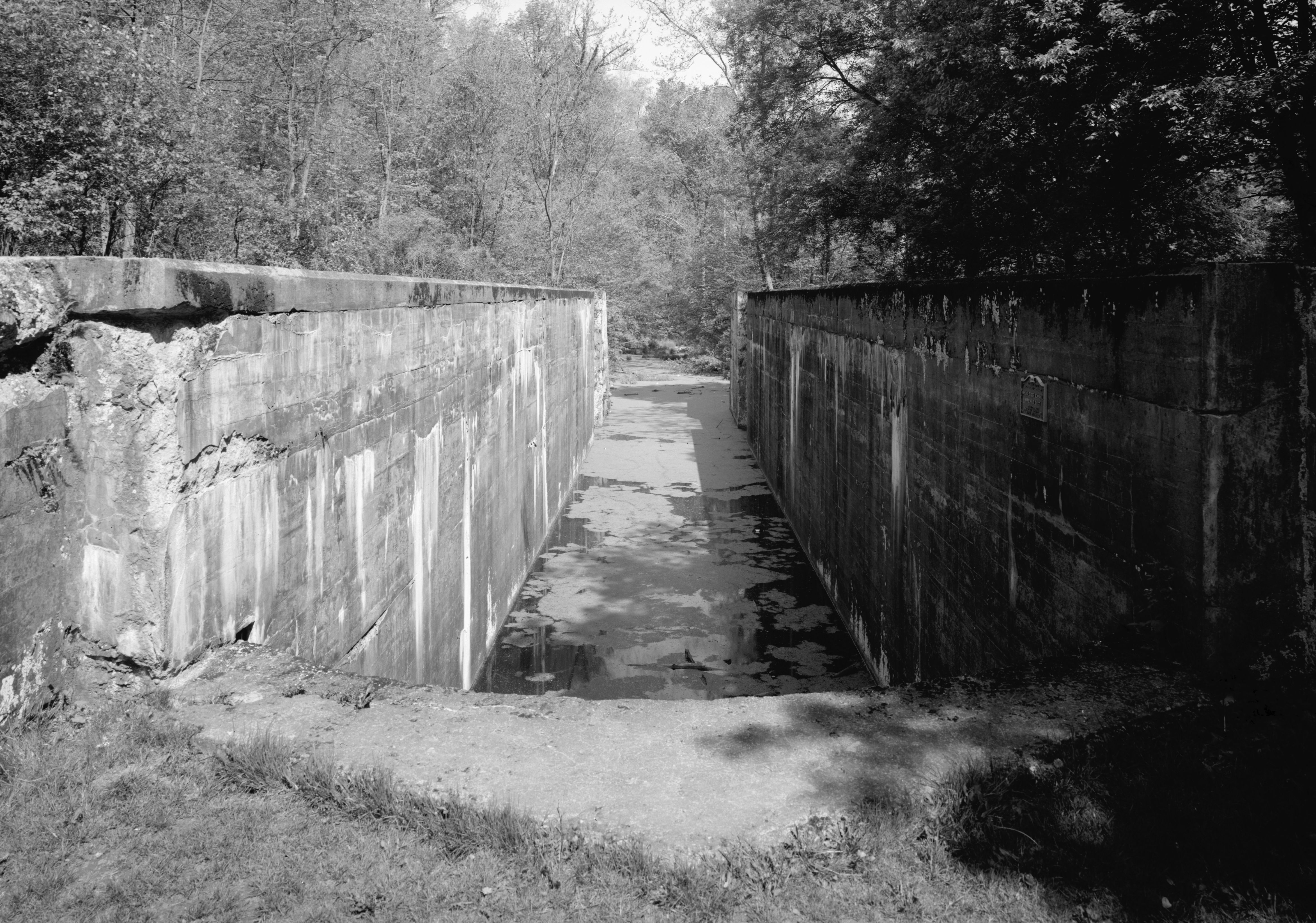
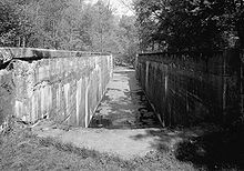 Deep Lock 28 as it existed in 1985
 44_North
 Mill_Creek
 Tinkers_CreekPeninsulaFurnace_RunAkronCanal_Fulton
 Sandy BeaverBolivarWalhondingBaltimoreCanal_WinchesterLockbourneCarrollOhio Canal system
Ohio and Erie Canal Towpath Trail Landmarks Mile
Post
B[›]ID
#Coordinates Elevation Name Type Municipality County Description 0 44 North 41°29′39.76″N 81°42′10.4″W / 41.4943778°N 81.702889°W[21] 0 feet (0 m) Cuyahoga River Sloop Lock Cleveland Cuyahoga Merwin Street between James street and West street 43 North 0 feet (0 m) Lock Cleveland Cuyahoga Sherwin Williams, James and West, Merrwin and Vineyard 0 feet (0 m) Weigh Lock Cleveland Cuyahoga Seneca a.k.a. West 3rd. street 3 42 North 0 feet (0 m) Lock Cleveland Cuyahoga relocated to 42A, 3 42A North 0 feet (0 m) Weigh and Guard Lock Cleveland Cuyahoga near Grasselli chemical company, Dille street and Independence road 5 41 North 41°26′49.38″N 81°40′56.88″W / 41.44705°N 81.6824667°W[22] 0 feet (0 m) RathBuns Lock Cuyahoga near Austin Powder Works, Harvard Road, near Jennings Road 8 40 North 41°25′8.82″N 81°38′38.58″W / 41.4191167°N 81.64405°W[23] 0 feet (0 m) Willow Lock Cuyahoga Heights Cuyahoga off Canal Road, near I-77 41°25′2.53″N 81°38′18.88″W / 41.4173694°N 81.6385778°W[24] 0 feet (0 m) Mill Creek Aqueduct Cuyahoga Heights Cuyahoga carries canal over Mill Creek (Cuyahoga River) off Canal Road 41°24′57″N 81°38′2″W / 41.41583°N 81.63389°W[4] 0 feet (0 m) GNIS GNIS 17 Cleveland South topographic map Bridge Cuyahoga Rockside Road TrailHead Cuyahoga CVSR 11 MilePost Marker Cuyahoga 11 39 North 41°23′24.22″N 81°37′28.95″W / 41.3900611°N 81.6247083°W[25] 590 feet (180 m)[26] Lock Independence Cuyahoga 41°23′4″N 81°37′7″W / 41.38444°N 81.61861°W[4] 0 feet (0 m) GNIS GNIS 16 Shaker Heights topographic map 12 MilePost Marker Cuyahoga Bridge Cuyahoga Hillside Road TrailHead Cuyahoga CVSR-Canal Visitor Center, 7104 Canal Road and Hillside Road 12 38 North 41°22′20.78″N 81°36′46.23″W / 41.3724389°N 81.6128417°W[27] 600 feet (180 m)[28] Lock Valley View Cuyahoga Canal Visitor Center Cuyahoga County Tinkers Creek Road 13 MilePost Marker Cuyahoga 41°21′53″N 81°36′32″W / 41.36472°N 81.60889°W[29] 610 feet (190 m)[29] Tinkers Creek Aqueduct Cuyahoga carries canal over Tinkers Creek (Cuyahoga River)A[›] Bridge Cuyahoga Alexander Road-Pleasant Valley Road 14 37 North 41°21′24.06″N 81°35′49.02″W / 41.3566833°N 81.59695°W[30] 620 feet (190 m)[31] Lock Cuyahoga Alexander's Mill Mill Cuyahoga Alexanders (a.k.a. Wilsons) 14 MilePost Marker Cuyahoga Trailhead Cuyahoga Sagamore Road 15 MilePost Marker Cuyahoga 16 MilePost Marker Cuyahoga 41°21′20″N 81°35′46″W / 41.35556°N 81.59611°W[4] 0 feet (0 m) GNIS GNIS 15 Northfield topographic map 17 36 North 41°19′23.06″N 81°35′11.9″W / 41.3230722°N 81.586639°W[32] 0 feet (0 m)[33] Pinery Dam and Feeder Lock Summit Bridge Summit SR-82 17 MilePost Marker Summit TrailHead Summit Station Road bridge to CVSR-Brecksville 19 35 North 41°18′45.43″N 81°34′59.89″W / 41.3126194°N 81.5833028°W[34] 0 feet (0 m)[35] Kettlewell Whiskey Lock Summit 18 MilePost Marker Summit Trail Summit Old Carriage Trail Summit Old Carriage Connector 19 MilePost Marker Summit 20 34 North 41°17′21.08″N 81°33′51.99″W / 41.2891889°N 81.5644417°W[36] 0 feet (0 m)[37] Red Lock Summit Jaite in southwestern Northfield Township[38] TrailHead Red Lock Bridge Summit Highland Road 20 MilePost Marker Summit 20.5 33 North 41°16′33.52″N 81°33′38.14″W / 41.2759778°N 81.5605944°W[39] 0 feet (0 m)[40] Wallace Lock Summit in Boston Township[41] 21 MilePost Marker Summit 21 32 North 41°15′56″N 81°33′31″W / 41.26556°N 81.55861°W[42] 659 feet (201 m)[42] Boston Lock Summit Boston Township Summit Boston Mills Road TrailHead Summit CVSR-Boston Store Bridge Summit I-271 Southbound Bridge Summit I-271 Northbound Bridge Summit I-80 Westbound Bridge Summit I-80 Eastbound 22 MilePost Marker Summit Summit Stumpy Basin 22 31 North 41°15′5.93″N 81°32′45.36″W / 41.2516472°N 81.5459333°W[43] 670 feet (200 m)[44] Lonesome Lock Summit was in Boston Township[45] 23 MilePost Marker Summit 23 30 North 41°14′44.04″N 81°33′14.87″W / 41.2455667°N 81.5541306°W[46] 680 feet (210 m)[47] Peninsula Feeder Lock Peninsula Summit Peninsula TrailHead Peninsula Summit CVSR 23 29 North 41°14′33.54″N 81°33′1.29″W / 41.24265°N 81.5503583°W[48] 690 feet (210 m)[49] Peninsula Lock Peninsula Summit 41°14′33.01″N 81°33′0.86″W / 41.2425028°N 81.5502389°W[50] 700 feet (210 m)[51] Peninsula Aqueduct Peninsula Summit carried canal over Cuyahoga River Bridge Summit SR-303 24 MilePost Marker Summit 25 28 North 41°13′57.38″N 81°33′6.77″W / 41.2326056°N 81.5518806°W[52] 700 feet (210 m)[52][53] Deep Lock Peninsula Summit at 17 feet (5.2 m) the deepest lock along the canal TrailHead Summit Deep Lock Quarry 25 MilePost Marker Summit 26 MilePost Marker Summit 27 27 North 41°12′16.25″N 81°34′15.43″W / 41.2045139°N 81.5709528°W[54] 710 feet (220 m)[55] Johnny Cake Lock Summit 41°12′7″N 81°34′21″W / 41.20194°N 81.5725°W[56] 718 feet (219 m)[56] Furnace Run Aqueduct Summit carried canal over Furnace Run (Cuyahoga River) 27 MilePost Marker Summit Bridge Summit Bolanz Road 28 MilePost Marker Summit Summit Beaver Marsh 28 26 North 41°11′7.74″N 81°34′52.05″W / 41.1854833°N 81.581125°W[57][58] 718 feet (219 m)[57] Pancake Lock Summit Ira TrailHead Summit CVSR 29 MilePost Marker Summit 28 25 North 41°10′32.27″N 81°34′46.82″W / 41.1756306°N 81.5796722°W[59] 0 feet (0 m)[60] Mudcatcher Lock Summit 30 24 North 41°10′20.5″N 81°34′40.93″W / 41.172361°N 81.5780361°W[61] 0 feet (0 m)[62] Niles Lock Summit Bridge Summit Yellow Creek (Cuyahoga River) 30 MilePost Marker Summit Bridge Summit Bath Road Indian Mound TrailHead Summit CVSR 41°3′57″N 81°32′12″W / 41.06583°N 81.53667°W[4] 0 feet (0 m) GNIS GNIS 14 Akron West topographic map 32 23 North 0 feet (0 m) Booth port Lock Summit sewer pipe 32 22 North Booth port Lock Summit Merriman sewer pipe 33 21 North Lock Summit sewer over-flow 20 North Lock Summit train abutments 19 North Black Dog Crossing Lock Summit near Hickory and Memorial 35 18 North Lock Summit 36 17 North Lock Summit 36 16 North Lock Summit 36 15 North Akron Mustill Store Lock Akron Summit 36 14 North Lock Akron Summit North Street 36 13 North Lock Akron Summit 36 12 North Lock Akron Summit 36 11 North Lock Akron Summit 36 10 North Lock Akron Summit 9 North Lock Akron Summit north of Market street 8 North Lock Akron Summit tunnel 37 7 North Lock Akron Summit middle tunnel 37 6 North Lock Akron Summit tunnel below parking deck North of Mill street 37 5 North Lock Akron Summit tunnel 37 4 North Lock Akron Summit tunnel 37 3 North Lock Akron Summit South Main street 38 2 North Lock Akron Summit Water street 38 1 North Lock Akron Summit West Exchange street 0 Portage landing Lock Akron Summit Portage lakes, Manchester Road 1 South Wolf creek Lock Barberton Summit Snyder avenue Wolf creek Aqueduct Barberton Summit Snyder avenue 40°54′37″N 81°37′51″W / 40.91028°N 81.63083°W[4] 0 feet (0 m) GNIS GNIS 13 Doylestown topographic map 2 South Lock New Franklin Stark Center Road 3 South Lock New Franklin Stark Center Road 40°53′2″N 81°35′37″W / 40.88389°N 81.59361°W[4] 0 feet (0 m) GNIS GNIS 12 Canal Fulton topographic map 4 South Lock Canal Fulton Stark 40°51′30″N 81°34′16″W / 40.85833°N 81.57111°W[4] 0 feet (0 m) GNIS GNIS 11 Massillon topographic map 40°39′32″N 81°27′22″W / 40.65889°N 81.45611°W[4] 0 feet (0 m) GNIS GNIS 10 Bolivar topographic map 39°58′17″N 82°29′15″W / 39.97139°N 82.4875°W[4] 0 feet (0 m) GNIS GNIS 9 Thornville topographic map 39°53′22″N 82°32′21″W / 39.88944°N 82.53917°W[4] 0 feet (0 m) GNIS GNIS 8 Millersport topographic map 5 South Lock 5A South Lock Lock Lock 31 South Lock 32 South Lock 33 South Lock North 20 Lock North 19 Lock North 18 Lock Lock Lock North 1 Lock North 0 Minthorn Lock Newark Licking South 0 Pugh Lock South 1 195 King Watson Lock Canal Road 39°51′41″N 82°33′38″W / 39.86139°N 82.56056°W[4] 0 feet (0 m) GNIS GNIS 7 Baltimore topographic map 196 South 2 David Miller's White Mill Lock Baltimore Fairfield 197.4 South 3 Norris Mill Lock Baltimore Fairfield South 4 Short Level Lock Baltimore Fairfield 198 South 5 Dry Dock Lock Baltimore Fairfield 198.3 South 6 Mulnix Mill Lock Baltimore Fairfield 198.8 South 7 Wells Mill Lock Basil, Ohio 200 South 8 Bibler Lock Basil, Ohio 208 South 9 Lock Carroll Fairfield South 10 Lock Carroll, Ohio Fairfield 206 South 11 Lock Violet Township Fairfield County, Ohio Upper Lockville South 12 Tennis/Tennat Lock Lockville South 13 Rowe Lock Lockville South 14 Smallwood Lock South 15 Fickle Mill Short Level Lock Lockville South 16 Rover Short Level Lock Lockville South 17 Swimmer's Lock Lockville South 18 Creek Lock Lockvile 208 Walnet Creek Guard Lock 39°51′16″N 82°52′19″W / 39.85444°N 82.87194°W[4] 0 feet (0 m) GNIS GNIS 6 Canal Winchester topographic map 210 South 19 Chaney's Mill Lock Canal Winchester 210 South 20 Woolen Lock Canal Winchester Gender Road South 21 Lock Canal Winchester near Glenarda Farms, Groveport Road George's Culvert Canal Winchester South 22 Groveport Lock 39°51′14″N 82°52′34″W / 39.85389°N 82.87611°W[4] 0 feet (0 m) GNIS GNIS 5 Lockbourne topographic map 217 South 23 Lock Lockbourne Franklin Canal Road 217 South 24 Lock Lockbourne Franklin Canal Road 217 South 25 Lock Lockbourne Franklin Canal Road 217.5 South 26 Lock Lockbourne Franklin 218 South 27 Lock Lockbourne Franklin Canal Road 218 South 28 Lock Lockbourne Franklin under railroad track bed South 29 Lock South 30 Lock Lockbourne Franklin Lockmeadows Park 39°48′45″N 82°43′37″W / 39.8125°N 82.72694°W[4] 0 feet (0 m) GNIS GNIS 4 Carroll topographic map 39°45′0″N 82°39′49″W / 39.75°N 82.66361°W[4] 0 feet (0 m) GNIS GNIS 3 Amanda topographic map 39°39′55″N 82°58′8″W / 39.66528°N 82.96889°W[4] 0 feet (0 m) GNIS GNIS 2 Ashville topographic map 40°25′20″N 81°24′17″W / 40.42222°N 81.40472°W[4] 0 feet (0 m) GNIS GNIS 1 New Philadelphia topographic map Columbus Feeder East Guard Lock Columbus Feeder West Guard Lock 226 South 31 Ashville Campbells Mill Lock 237 South 32 Aqueduct Lock Scioto River, West of Circleville 237 Circleville Feeder Lock Spunkytown 238 South 33 Lock Wayne Township 238 South 34 Lock Wayne Township South 35 Lock Chillicothe, Ohio 256 South 36 Lock Chillicothe, Ohio 258 South 37 Lock Chillicothe, Ohio parking lot South 38 Fifth Street Lock Chillicothe, Ohio 261 South 39 Upper Lunbeck Lock 261 South 40 Lower Lunbeck Lock Scioto Township Pickaway near Renick Lane 601 South 41 Tomlinsons Lock 3 Locks Road, South of Chillicothe South 42 Tomlinsons Lock South 43 Tomlinsons Lock Tomlinsons Dam and Feeder Guard Lock South 44 Waverly Lock 280 South 45 U Pee Pee Lock 280 South 46 L Pee Pee Lock 291 South 47 Howards Lock near Robers 18 mi (29 km) Lock Farm South 48 Herod's Lock South 49 Rushs Brush Creek Lock South 50 Union Mills Lock South 51 Union Mills Moss Lock near Ohio State Route 239 South 52 Union Mills Lock 305 South 53 Elbow Lock South 54 Lock Portsmouth Scioto County 308 South 55 Lock Scioto County near Old River Road, Portsmouth/Alexandria Travels through Cuyahoga, Summit, Stark, Licking, Franklin, Fairfield, Pickaway, and Scioto counties.[4]
See also
- Canal Fulton, Ohio
- Chesapeake and Ohio Canal
- List of canals in the United States
- Miami and Erie Canal
Notes
^ A: In 2007-2008-? Tinkers Creek Aqueduct is undergoing renovation following flood damage from Tinkers Creek (Cuyahoga River) and Cuyahoga River
^ B: Ohio and Erie Canal Towpath Trail miles are measured from its original connection with Lake Erie at Lock 44 on the Cuyahoga River, and marked with a 3.3 feet (1.0 m)-tall sandstone obelisk at each mile mark.References
- ^ a b c Mendinghall, Joseph S. (February 28, 1975). National Register of Historic Places Inventory-Nomination: Ohio and Erie Canal. National Park Service. http://pdfhost.focus.nps.gov/docs/NHLS/Text/66000607.pdf and Accompanying ___ photos, exterior and interior, from 19__ (to be described when NPS website, malfunctioning now, serves up the PDF file properly)PDF (3.94 MB)
- ^ "National Register Information System". National Register of Historic Places. National Park Service. 2007-01-23. http://nrhp.focus.nps.gov/natreg/docs/All_Data.html.
- ^ a b "Ohio and Erie Canal". National Historic Landmark summary listing. National Park Service. http://tps.cr.nps.gov/nhl/detail.cfm?ResourceId=442&ResourceType=District. Retrieved 2008-06-20.
- ^ a b c d e f g h i j k l m n o p q r s "Ohio Canal". Geographic Names Information System, U.S. Geological Survey. http://geonames.usgs.gov/pls/gnispublic/f?p=gnispq:3:::NO::P3_FID:1080438. Retrieved 2009-05-03.
- ^ "History Ohio's Canals.". Ohio Department of Natural Resources. http://www.dnr.state.oh.us/water/canlhist/tabid/3285/Default.aspx.
- ^ Hagerty, J.E., McClelland C.P. and Huntington, C.C., History of the Ohio Canals, Their construction, cost, use and partial abandonment, Ohio State Archaeological and Historical Society, Columbus, OH 1905
- ^ Ohio & Erie, Miami & Erie Canal Plat Maps Main Page
- ^ Ehmann P&O
- ^ http://www.webcitation.org/query?url=http://www.geocities.com/heartland/prairie/6687/pennohio.htm&date=2009-10-25+23:48:48
- ^ a b c "Captain Pearl R. Nye: Life on the Ohio and Erie Canal". http://memory.loc.gov/cgi-bin/query/r?ammem/afcnyebib:@field(DOCID+@lit(afcnye000056)). Retrieved 2007-04-21.
- ^ by Jack Gieck; with an introduction by George W. Knepper (1988). A photo album of Ohio's canal era, 1825-1913. [Kent, Ohio]: Kent State University Press. ISBN 0-87338-353-2.
- ^ "Biography of James Garfield". The White House. http://www.whitehouse.gov/history/presidents/jg20.html. Retrieved 2006-03-14.
- ^ "James A. Garfield". American Presidents: Life Portraits. http://www.americanpresidents.org/presidents/president.asp?PresidentNumber=20. Retrieved 2006-03-14.
- ^ Historic Canal System Current Status - Year 2000 Map
- ^ "Canals of Ohio 1825-1913 map" (JPEG). The Ohio Historical Society, Columbus, Ohio; National Park Service, United States Department of the Interior. http://www.nps.gov/history/nr/twhp/wwwlps/lessons/41ohio/41images/41map1bh.jpg.
- ^ "Pennsylvania and Ohio Canal (historical)". Geographic Names Information System, U.S. Geological Survey. http://geonames.usgs.gov/pls/gnispublic/f?p=gnispq:3:::NO::P3_FID:1877555. Retrieved 2009-05-03.
- ^ a b "Sandy Beaver Canal". Geographic Names Information System, U.S. Geological Survey. http://geonames.usgs.gov/pls/gnispublic/f?p=gnispq:3:::NO::P3_FID:1045950. Retrieved 2009-05-03.
- ^ a b "Sandy Beaver Canal". Geographic Names Information System, U.S. Geological Survey. http://geonames.usgs.gov/pls/gnispublic/f?p=gnispq:3:::NO::P3_FID:1045951. Retrieved 2009-05-03.
- ^ a b "Walhonding Canal". Geographic Names Information System, U.S. Geological Survey. http://geonames.usgs.gov/pls/gnispublic/f?p=gnispq:3:::NO::P3_FID:1047500. Retrieved 2009-05-03.
- ^ "Ohio and Erie Canal". Cleveland Memory, Cleveland State University Libraries. http://www.clevelandmemory.org/SpecColl/canal/unrau191.htm.
- ^ Lock 44 manually plotted in Google Earth
- ^ "Ohio and Erie Canal and Towpath Trail, Part 2". NorthEastOhio-RoadRunner. http://home.neo.rr.com/towpath2/CuyahogaCounty2.htm.
- ^ "Ohio and Erie Canal and Towpath Trail, Part 3". NorthEastOhio-RoadRunner. http://home.neo.rr.com/towpath3/CuyahogaCounty3.htm.
- ^ Mill Creek Aqueduct manually plotted in Google Earth
- ^ Eleven Mile Lock 39 manually plotted in Google Earth
- ^ "Eleven Mile Lock 39 topographic map". USGS via Microsoft Research Maps. http://msrmaps.com/map.aspx?t=2&s=11&lon=-81.624708&lat=41.390061&w=600&h=400&opt=0.
- ^ Twelve Mile Lock 38 manually plotted in Google Earth
- ^ "Twelve Mile Lock 38 topographic map". USGS via Microsoft Research Maps. http://msrmaps.com/map.aspx?t=2&s=11&lon=-81.612842&lat=41.372439&w=600&h=400&opt=0.
- ^ a b "Tinkers Creek Aqueduct". Geographic Names Information System, U.S. Geological Survey. http://geonames.usgs.gov/pls/gnispublic/f?p=gnispq:3:::NO::P3_FID:1073893. Retrieved 2009-05-03.
- ^ Fourteen Mile Lock 37 manually plotted in Google Earth
- ^ "Fourteen Mile Lock 37 topographic map". USGS via Microsoft Research Maps. http://msrmaps.com/map.aspx?t=2&s=11&lon=-81.59695&lat=41.356683&w=1024&h=768&opt=0.
- ^ Pinery Dam and Feeder Lock 36 manually plotted in Google Earth
- ^ Pinery Dam and Feeder Lock 36 topographic map
- ^ Kettlewell Whiskey Lock 35 manually plotted in Google Earth
- ^ Whiskey Lock 35 topographic map
- ^ Red Lock 34 manually plotted in Google Earth
- ^ Red Lock 34 topographic map
- ^ "Red Lock (historical)". Geographic Names Information System, U.S. Geological Survey. http://geonames.usgs.gov/pls/gnispublic/f?p=gnispq:3:::NO::P3_FID:1074638. Retrieved 2009-05-03.
- ^ Wallace Lock 33 manually plotted in Google Earth
- ^ Wallace Lock 33 topographic map
- ^ "Wallace Lock (historical)". Geographic Names Information System, U.S. Geological Survey. http://geonames.usgs.gov/pls/gnispublic/f?p=gnispq:3:::NO::P3_FID:1074647. Retrieved 2009-05-03.
- ^ a b "Boston Lock". Geographic Names Information System, U.S. Geological Survey. http://geonames.usgs.gov/pls/gnispublic/f?p=gnispq:3:::NO::P3_FID:1074620. Retrieved 2009-05-03.
- ^ Lonesome Lock 31 manually plotted in Google Earth
- ^ "Lonesome Lock 31 topographic map". USGS via Microsoft Research Maps. http://msrmaps.com/map.aspx?t=2&s=11&lon=-81.545933&lat=41.251647&w=600&h=400&opt=0.
- ^ "Lonesome Lock (historical)". Geographic Names Information System, U.S. Geological Survey. http://geonames.usgs.gov/pls/gnispublic/f?p=gnispq:3:::NO::P3_FID:1074633. Retrieved 2009-05-03.
- ^ Peninsula Feeder Lock 30 manually plotted in Google Earth
- ^ "Peninsula Feeder Lock 30 topographic map". USGS via Microsoft Research Maps. http://msrmaps.com/map.aspx?t=2&s=11&lon=-81.554131&lat=41.245567&w=600&h=400&opt=0.
- ^ Peninsula Lock 29 manually plotted in Google Earth
- ^ "Peninsula Lock 29 topographic map". USGS via Microsoft Research Maps. http://msrmaps.com/map.aspx?t=2&s=11&lon=-81.550358&lat=41.24265&w=600&h=400&opt=0.
- ^ Peninsula Aqueduct manually plotted in Google Earth
- ^ "Peninsula Aqueduct topographic map". USGS via Microsoft Research Maps. http://msrmaps.com/map.aspx?t=2&s=11&lon=-81.550239&lat=41.242503&w=600&h=400&opt=0.
- ^ a b "Deep Lock (historical)". Geographic Names Information System, U.S. Geological Survey. http://geonames.usgs.gov/pls/gnispublic/f?p=gnispq:3:::NO::P3_FID:1067315. Retrieved 2009-05-03. Deep Lock manually plotted in Google Earth
- ^ "Deep Lock 28 topographic map". USGS via Microsoft Research Maps. http://msrmaps.com/map.aspx?t=2&s=11&lon=-81.551881&lat=41.232606&w=600&h=400&opt=0.
- ^ Johnny Cake Lock 27 manually plotted in Google Earth
- ^ "Johnny Cake Lock 27 topographic map". USGS via Microsoft Research Maps. http://msrmaps.com/map.aspx?t=2&s=11&lon=-81.570953&lat=41.204514&w=600&h=400&opt=0.
- ^ a b "Furnace Run Aqueduct". Geographic Names Information System, U.S. Geological Survey. http://geonames.usgs.gov/pls/gnispublic/f?p=gnispq:3:::NO::P3_FID:1073291. Retrieved 2009-05-03.
- ^ a b "Pancake Lock (historical)". Geographic Names Information System, U.S. Geological Survey. http://geonames.usgs.gov/pls/gnispublic/f?p=gnispq:3:::NO::P3_FID:1058454. Retrieved 2009-05-03.
- ^ Pancake Lock 26 manually plotted in Google Earth
- ^ Mudcatcher Lock 25 manually plotted in Google Earth
- ^ Mudcatcher Lock 25 topographic map
- ^ Niles Lock 24 manually plotted in Google Earth
- ^ Niles Lock 24 topographic map
General References
-
- "Ohio and Erie Canal Map" (JPEG). National Park Service, United States Department of the Interior. http://www.cr.nps.gov/NR/TWHP/wwwlps/lessons/41ohio/41images/41map1bh.jpg.
- "Ohio and Erie Canal towpath trail". National Park Service, United States Department of the Interior. http://www.nps.gov/cuva/planavisit/todo/recreation/ohioerie.htm.
- "Ohio and Erie Canal National Heritage Corridor, a National Park Service Discover Our Shared Heritage Travel Itinerary". National Park Service, United States Department of the Interior. http://www.nps.gov/history/nr/travel/ohioeriecanal/.
- "The Ohio & Erie Canal: Catalyst of Economic Development for Ohio, a National Park Service Teaching with Historic Places (TwHP) lesson plan". National Park Service, United States Department of the Interior. http://www.nps.gov/history/NR/twhp/wwwlps/lessons/41ohio/41ohio.htm.
- "Chapter 13 Transportation - Canals" (PDF). Ohio Department of Natural Resources. http://www.dnr.state.oh.us/Portals/13/gis/pdf/coastalatlas2/CH13_transportation.pdf. Retrieved 2008-07-21.[dead link]
- "The Ohio and Erie Canal in Cleveland". Cleveland Memory, Cleveland State University Libraries. http://www.clevelandmemory.org/SpecColl/canal/canalhist.html.
External links
- Report from the 1872 Inspection of the Ohio & Erie Canal
- Images of the Ohio & Erie Canal at Summit Memory
- Ohio and Erie Canal National Heritage Corridor
- Ohio and Erie Canal Photo Essay
- An Inquisitive Visitor's Guide to the Ohio & Erie Canal and Towpath Trail
- "Water And Steel, Concrete And Earth", Erin O'Brien (writer), Cleveland Free Times, July 25, 2007
- Pictures around Waverly
- Southern Ohio Museum The Ackerman Collection of Historical Photographs
National Register of Historic Places in Cuyahoga Valley National Park National Historic Landmark District Ohio and Erie Canal
Other historic districts Botzum Farm | Camp Manatoc Foresters Lodge and Kit Carson-Dan Boone Cabins Historic District | Edward Cranz Farm | William and Eugene Cranz Farm | Michael Duffy Farm | Everett Historic District | Everett Knoll Complex | Jaite Mill Historic District | Virginia Kendall State Park Historic District | Peninsula Village Historic District | Terra Vista Archeological District | Valley Railway Historic District
National Register properties Barker Village Site | Jim Brown House] | Jim Brown Tavern | William Burt House | H. Karl Butler Memorial | Camp Manatoc Concord Lodge and Adirondacks Historic District | Camp Manatoc Dining Hall | Camp Manatoc Legion Lodge | Albert Cofta Farmstead | Jonas Coonrad House | Fort Island Works | Stephen Frazee House | Furnace Run Aqueduct | Edmund Gleason Farm | Hunt-Wilke Farm | William Knapp House | Lock No. 26 | Lock No. 27 | Lock No. 28 | Lock No. 29 and Aqueduct | Lock No. 30 and Feeder Dam | Lock No. 31 | Lock No. 32 | Lock No. 33 | Lock No. 34 | Lock No. 35 | Lock No. 37 and Spillway | Lock No. 38 and Spillway | Lock No. 39 and Spillway | Lock Tender's House and Inn | Lutz-Martin Farm | Ohio and Erie Canal Deep Lock | Packard-Doubler House | Nathaniel Point Farm | Charles B. Rich House | Russ and Holland Snow Houses | South Park Site | George Stanford Farm | Station Road Bridge | Stebbens Farm | Stumpy Basin | Daniel Tilden House | Tinkers Creek Aqueduct | Abraham Ulyatt House | Richard Vaughn Farm | Wallace Farm | Allen Welton House | Wilson Feed Mill
U.S. National Register of Historic Places Topics Lists by states Alabama • Alaska • Arizona • Arkansas • California • Colorado • Connecticut • Delaware • Florida • Georgia • Hawaii • Idaho • Illinois • Indiana • Iowa • Kansas • Kentucky • Louisiana • Maine • Maryland • Massachusetts • Michigan • Minnesota • Mississippi • Missouri • Montana • Nebraska • Nevada • New Hampshire • New Jersey • New Mexico • New York • North Carolina • North Dakota • Ohio • Oklahoma • Oregon • Pennsylvania • Rhode Island • South Carolina • South Dakota • Tennessee • Texas • Utah • Vermont • Virginia • Washington • West Virginia • Wisconsin • WyomingLists by territories Lists by associated states Other Categories:- Historic districts in Ohio
- Articles to be expanded with sources
- Canals in Ohio
- Ohio River
- National Historic Landmarks in Ohio
- Economy of Cleveland, Ohio
- Canals on the National Register of Historic Places
- Cuyahoga Valley National Park


Wikimedia Foundation. 2010.