- Mount Yōtei
-
Mount Yōtei 羊蹄山 Yōteizan 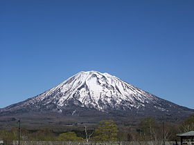
Mount Yōtei from Hirafu (May 20, 2005)Elevation 1,898 m (6,227 ft) [1] Prominence 1,878 m (6,161 ft) [1] Listing List of mountains and hills of Japan by height
100 Famous Japanese Mountains
List of volcanoes in Japan
UltraLocation Hokkaidō, Japan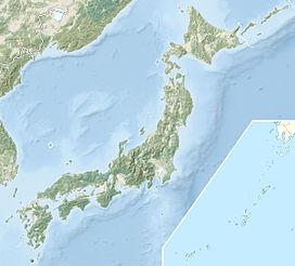
 Mount Yōtei
Coordinates 42°49′36″N 140°48′41″E / 42.82667°N 140.81139°ECoordinates: 42°49′36″N 140°48′41″E / 42.82667°N 140.81139°E[1] Topo map Geographical Survey Institute 25000:1 羊蹄山
50000:1 留寿都Geology Type Stratovolcano Age of rock Quaternary Last eruption 1050 BC Mount Yōtei (羊蹄山 Yōteizan) is an active[2] stratovolcano located in Shikotsu-Toya National Park, Hokkaidō, Japan. It is also called 'Yezo Fuji or Ezo Fuji (蝦夷富士), because it resembles the more famous Mount Fuji. The mountain is also known as Makka Nupuri (マツカリヌプリ) and Mount Shiribeshi (後方羊蹄山 Shiribeshi-Yama).[2] It is one of the 100 famous mountains in Japan.
Contents
Geology
Mount Yotei is mostly composed of andesite and dacite.[2][3] The stratovolcano is symmetrical adding to its resemblance to Mount Fuji.
Eruptive history
Tephrochronology indicates two eruptions at Mount Yotei. The most recent circa 1050 BC from a cone emerging from the northwest flank of the mountain at Lake Hangetsu (Hangetsu-Ko). The earlier eruption is dated from circa 3550 BC.[4]
See also
References
- ^ a b c http://www.peaklist.org/WWlists/ultras/japan.html
- ^ a b c "YOTEI-ZAN". Quaternary Volcanoes in Japan. Geological Survey of Japan, AIST. 2006. http://riodb02.ibase.aist.go.jp/strata/VOL_JP/EN/vol/194.htm. Retrieved 2008-09-27.
- ^ "Yotei". Global Volcanism Program. Smithsonian National Museum of Natural History. http://www.volcano.si.edu/world/volcano.cfm?vnum=0805-032. Retrieved 3 December 2009.
- ^ "Yotei:Eruptive History". Global Volcanism Program. Smithsonian National Museum of Natural History. http://www.volcano.si.edu/world/volcano.cfm?vnum=0805-032&volpage=erupt. Retrieved 3 December 2009.
Categories:- Active volcanoes
- Stratovolcanoes
- Volcanoes of Hokkaidō
- Shikotsu-Tōya National Park
- Mountains of Hokkaidō
- Hokkaidō geography stubs
- Japan protected area stubs


Wikimedia Foundation. 2010.