- Mount Iide
-
Mount Iide 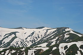
Mount Iide seen from IboiwayamaElevation 2,105 m (6,906 ft) Location Location Fukushima, Tōhoku region, Japan 
Range Iide mountain range Coordinates 37°51′17″N 139°42′26″E / 37.85472°N 139.70722°E Mount Iide (飯豊山 Iide-san) is the main peak of the Iide mountain range that spans over the Fukushima, Niigata and Yamagata prefectures in Japan. On top of the mountain stands the Mount Iide Shrine (飯豊山神社). Mount Iide is, together with the rest of the range, one of the mountains described in Kyūya Fukada's book 100 Famous Japanese Mountains.[1]
Mount Iide is located at 2105 m[2] above sea level but is not the highest peak of the Iide mountain range even though it is the main peak of the range. The highest is Mount Dainichi (大日岳 Dainichi-dake) that is 2128 m high.[2]
The mountain is located on the border between Niigata prefecture and Yamagata prefecture, but the summit itself, Mount Iide Shrine and a path roughly one meter wide leading there belongs to Kitakata, Fukushima. This was a response to complaints when Higashikanbara District was transferred from Fukushima to Niigata during the Meiji period. As a result Fukushima prefecture has an uneven border, with an arm stretching through the Iide mountain range up to the Mount Iide Shrine.[3]
References
- ^ Fukada, Kyūya (1978). 日本百名山 (Nihon hyaku meizan) (Kaihan. ed.). Tōkyō: Shinchōsha. pp. 108–112. ISBN 9784101220024.
- ^ a b "山都町の紹介" (in Japanese). Kitakata-shi, Fukushima official webpage. http://www.city.kitakata.fukushima.jp/2600/2609/003445.html. Retrieved 5 August 2011.
- ^ "飯豊山の概要 > 飯豊山の歴史" (in Japanese). Kitakata Sightseeing Association. Kitakata City. http://www.kitakata-kanko.jp/iidesannomegumi/outline/history.php. Retrieved August 15, 2011.
See also
- List of the 100 famous mountains in Japan
 Media related to Mount Iide at Wikimedia Commons
This Fukushima Prefecture location article is a stub. You can help Wikipedia by expanding it.
