- Mount Echigo-Komagatake
-
Mount Echigo-Komagatake 越後駒ヶ岳 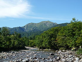
View from Ginzandaira (September 2009)Elevation 2,002.7 m (6,571 ft) [1] Listing List of mountains and hills of Japan by height
100 Famous Japanese MountainsLocation Niigata Prefecture, Japan
 Mount Echigo-Komagatake
Coordinates 37°07′25″N 139°04′31″E / 37.12361°N 139.07528°ECoordinates: 37°07′25″N 139°04′31″E / 37.12361°N 139.07528°E[1] Topo map Geospatial Information Authority 25000:1 八海山
50000:1 日光Mount Echigo-Komagatake or Uonuma-Komagatake (越後駒ヶ岳 or 魚沼駒ヶ岳) is a mountain located on the border of Uonuma and Minamiuonuma, Niigata Prefecture, Japan, with an elevation of 2,002.7 m (6,571 ft)[1] It is one of the 100 famous mountains in Japan.[2] Mount Echigo-Komagatake, along with Nakanodake and Mount Hakkai, is also one of the three great mountains of Echigo. (Echigo is the old name of Niigata.)
Contents
Geography
Mount Echigo-Komagatake lies in central part of Echigo Mountains, a mountain range over Niigata, Fukushima, and Gunma Prefecture. Between late autumn and early spring, large amount of snow falls in this region because of the monsoon from Siberia, with an average of 3 or 4 meters. Avalanches eroded the surface of the mountain and formed steep precipices, especially on the west and north face. Hikers can see snow on the mountain even in late summer. Thanks to the heavy snowfall, this mountain has many sources of rivers such as Kitanomata River, Mizunashi River, and Sanashi River, which all flow into Sea of Japan. Such abundant water is used mainly for paddy fields, and hydroelectricity.
In contrast to the winter season, it is hot and humid, and there are thunderstorms in the afternoon almost every day in the summer season. Hikers must pay attention to hyperthermia and thunderbolts.
Climbing routes
There are some climing routes. The easiest and most popular route is the one from Shiori Mountain Pass. (Japanese: 枝折峠) Other routes are Kushigahana route, Komanoyu route, and Echigo Sanzan mountain ridge route. All routes are long and demanding, but special technique isn't needed. It's possible to get back to the starting points except for the last one if start climing in the early morning. The best season is between June and early October. [3]
Transportation
Some bus routes are available from train stations (Muikamachi, Urasa or Koide) to the starting points. However, they are much less convenient than by car and taxi. At the starting points, several dozens of parking lots are available for free, but during the best season, the parking lots are quickly inundated with a lot of cars.[3]
Facilities
There are only one mountain lodge called Komanokoya (Japanese:駒の小屋) at about 100 meters below the summit. The caretakers stay between late April and the end of October. It costs 2000 Japanese yen to stay there without food, reservation not needed. In the snow season, climbers also use the lodge for shelter.[4]
References
- ^ a b c Geospatial Information Authority topographic map 八海山
- ^ Fukada, Kyuya (1964). 日本百名山. Shinchosha.
- ^ a b 越後三山岳友会. 山と高原地図⑮越後三山 Mountaineering map 15 Echigosanzan. Shobunsha Publications, Inc.. http://www.amazon.co.jp/%E8%B6%8A%E5%BE%8C%E4%B8%89%E5%B1%B1-%E5%B9%B3%E3%83%B6%E5%B2%B3%E3%83%BB%E5%B7%BB%E6%A9%9F%E5%B1%B1-2010%E5%B9%B4%E7%89%88-%E5%B1%B1%E3%81%A8%E9%AB%98%E5%8E%9F%E5%9C%B0%E5%9B%B3-15/dp/4398756957.
- ^ "Mapple Leisure Guide". Shobunsha Publications, Inc.. http://www.mapple.net/spots/G01500141201.htm.
External links
 Media related to Mount Echigo-Komagatake at Wikimedia CommonsCategories:
- Mountains of Niigata Prefecture
- Niigata Prefecture


Wikimedia Foundation. 2010.