- Clapham Junction railway station
-
Clapham Junction 

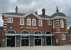
South West (Brighton Yard) entrance
Location of Clapham Junction in Greater LondonLocation Battersea Local authority London Borough of Wandsworth Managed by South West Trains Owner Network Rail Station code CLJ Number of platforms 16 Accessible  [1]
[1]Fare zone 2 National Rail annual entry and exit 2004-05  12.550 million[2]
2005-06  12.427 million[2]
2006-07  18.868 million[2]
- interchange 12.868 million[2] 2007-08  18.181 million[2]
2008-09  17.508 million[2]
- interchange 16.355 million[2] 2009-10  17.758 million[2]
- interchange 20.520 million[2] 2 March 1863 Opened List of stations Underground · National Rail External links Departures • Layout Facilities • Buses Coordinates: 51°27′53″N 0°10′14″W / 51.4646°N 0.1705°W
Clapham Junction railway station is near St John's Hill in the south-west of Battersea in the London Borough of Wandsworth. Although it is in Battersea, the area around the station is commonly identified as Clapham Junction.
Many routes from London's two busiest termini, London Waterloo and Victoria, funnel through the station making it one of the busiest in Europe by number of trains using it, more than one hundred an hour outside peak periods.
Contents
History
Before the railway came the area was rural and specialised in growing lavender; Lavender Hill is to the east of the station. The coach road from London to Guildford ran slightly south of the future station site, past The Falcon public house at the crossroads in the valley between St. John's Hill and Lavender Hill.
On 21 May 1838 the London and Southampton Railway, which became the London and South Western Railway (L&SWR) that day, opened its line from Nine Elms as far as Woking. That was the first railway through the area but it had no station at the present site.
The second line, initially from Nine Elms to Richmond, opened on 27 July 1846. Nine Elms was replaced in 1848 as the terminus by Waterloo Bridge station, now Waterloo. The line to Victoria opened by 1860. Clapham Junction station opened on 2 March 1863, a joint venture of the L&SWR, the London, Brighton and South Coast Railway (LB&SCR) and the West London Extension Railway (WLER) as an interchange station for their lines.[3]
When the station was built Battersea was regarded as a poor district while Clapham, a mile east, was more fashionable. The railway companies, to attract a middle and upper class clientele, adopted the grander of the two names, leading to a long-lasting misunderstanding that the station is in Clapham. A local action group, Love Battersea, was belatedly formed in 2005 to reduce the misapprehension.[4]
Additional station buildings were erected in 1874 and 1876.
The station brought development to the surrounding area whose population rose from 6,000 in 1840 to 168,000 by 1910.
Today
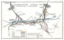
Railways around Clapham Junction Legend


London Waterloo 


Vauxhall 


London Victoria 


Linford curve, built for Eurostar 


HUB = Stewarts Lane Junc. 


To Wandsworth Road, CML 


To Wandsworth Road, CML 


Battersea Park 


Stewarts Lane TMD 


Queenstown Road (Battersea) 


|| HUB = Longhedge Juncs by 1912 map 


|| may have changed after grouping 


|| and end of freight 


|| Far left is West London Ext. Junc. 


Poupart's Jn 


Latchmere Jn for W'loo 


Latchmere Main Junc 


WLL. Latchmere SW Junc 


Ludgate Junc. 


Clapham Junction 


Carriage sidings 


Falcon Junc. 


To Wandsworth Common. Brighton Main Line 


To Earlsfield. SWML 


To Wandsworth Town. Wloo-Reading Line Each day about 2,000 trains, most stopping, pass through the station, more than through any other station in Europe.[citation needed] At peak times 180 trains per hour pass through of which 117 stop. It is not the busiest station by number of passengers, most of whom (about 430,000 on a weekday, of which 135,000 are at rush hours) pass through. Interchanges make some forty per cent of the activity and on that basis too it is the busiest station in the UK.[5]
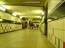
As of 2011, the station has three separate entrances, all of which have staffed ticket offices (though only the south east entrance is open 24 hours a day). The south east entrance, which is the most heavily used of the three, leads from St. John's Hill, via a small indoor shopping centre, into a subway some 15 ft (4.6 m) wide which connects to the eastern ends of all platforms.
The northern entrance, which has restricted opening hours, leads from Grant Road to the same subway. The subway is crowded during rush hours, ticket barriers at the ends are pinch points.
The south west entrance (also known as the Brighton Yard entrance, as the Victorian station buildings still bear signage for the London Brighton and South Coast Railway) is of a more traditional appearance, with a Victorian station building set at the back of a large forecourt. This entrance leads to a very wide covered footbridge, which joins the western ends of all platforms. This entrance includes cycle parking and a taxi rank. It was opened in May 2011, as part of a wider programme of access improvements which included installing lifts to the platforms.[6]
The station has full public and disabled toilet facilities at the south west entrance. There are refreshment kiosks in the underpass, on the overpass, and on some platforms; and a small shopping centre (including a small branch of Sainsbury's supermarket) in the St. John's Hill entrance.
British Transport Police maintain a neighbourhood policing presence at Clapham Junction.[7]
Future
Clapham Junction has no London Underground connection, but in 2007 the alignment of the proposed Chelsea-Hackney line possibly reaching Clapham Junction was safeguarded. The possibility of a further extension to the Northern line, once the extension to Battersea has been completed, has also been discussed.
The Secretary of State for Transport announced in February 2009 the allocation of £75m for extending the London Overground East London Line to Clapham Junction, a link which will connect Clapham Junction through Peckham Rye to Dalston Junction in north-east London. The extension is set to be completed by October 2012.
A planning application from Metro Shopping Fund for a £39.5 million project at the station was withdrawn shortly before Wandsworth Planning Committee was to consider it on 20 May 2009. The plan included a new entrance on St John's Hill, straightened and extended platforms 15-17, more ticketing facilities, an enhancement of current works to give step-free access to all platforms by 2011, a new step-free entrance on Grant Road, and a new 'high street' from St John's Hill to Falcon Road with retail space and an art house cinema. To pay for the rail improvements there would have been two 42-storey residential buildings above the station.
Clapham Junction is overcrowded during rush-hours and improvement is needed. In 2009 a mystery shopper assessment of fabric and environment listed the station in the ten worst category B interchange stations. It is to share a £50m funding for improvements.[8] It was referenced in the review as "upgrade interchange: new entrances & more retail".[9]
Heathrow Airtrack is a proposed rail link from Heathrow Airport running south to the Staines to Windsor Line to provide direct services to London Waterloo, calling at Clapham Junction, and to Reading and to Guildford. Clapham Junction would be an interchange for air passengers changing between Heathrow and Gatwick Airports. If permission was granted, work was forecast to begin in 2010, with rail services operating by 2014. As of April 2011, the project has been shelved.
Clapham rail disaster
On the morning of 12 December 1988 two collisions involving three commuter trains occurred slightly south-west of the station. Thirty-five people died and more than 100 were injured.
Services
All services from Waterloo, by South West Trains, and many from Victoria, by Southern and Gatwick Express, use the station as do the West London Line services of London Overground and Southern.
Typical off-peak service of more than 120 trains an hour comprises:
- 35 to London Waterloo
- 22 to London Victoria
- 1 to Alton
- 1 to Basingstoke (slow)
- 2 to Brighton (express)
- 1 to Brighton (slow)
- 2 to Caterham via Norbury
- 2 to Chessington South
- 1 to Dorking via Sutton
- 2 to Dorking via Wimbledon
- 2 to East Grinstead via Oxted
- 1 to Epsom Downs
- 2 to Epsom via Hackbridge
- 1 to Epsom via Norbury
- 1 to Exeter St Davids
- 2 to Guildford via Cobham
- 2 to Guildford via Epsom
- 2 to Hampton Court
- 1 to Haslemere
- 1 to Horsham via Sutton and Dorking
- 1 to Littlehampton and Eastbourne (dividing at Haywards Heath)
- 2 to London Bridge via Crystal Palace
- 2 to London Waterloo by the Hounslow Loop via Brentford, Hounslow and Richmond
- 2 to London Waterloo by the Hounslow Loop via Richmond, Hounslow and Brentford
- 2 to London Waterloo by the Kingston Loop via Wimbledon, Kingston and Richmond
- 2 to London Waterloo by the Kingston Loop via Richmond, Kingston and Wimbledon
- 1 to Milton Keynes Central via Kensington Olympia and Watford Junction
- 1 to Ore and Littlehampton, dividing at Haywards Heath and Eastbourne
- 1 to Poole
- 1 to Portsmouth and Southsea via Haslemere
- 1 to Portsmouth Harbour and Bognor Regis, dividing at Horsham
- 2 to Reading
- 2 to Shepperton
- 1 to Southampton Central and Bognor Regis, dividing at Horsham
- 1 to South Croydon via Norbury
- 2 to Sutton via Norbury
- 2 to West Croydon via Crystal Palace
- 2 to Weybridge via Brentford, Hounslow and Staines
- 1 to Weymouth
- 4 to Willesden Junction (of which 2 continue to Stratford)[10]
- 2 to Windsor & Eton Riverside
- 2 slow to Woking
Platforms
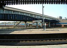
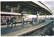
The station has 17 platforms, numbered 1 to 17 (number 1 is disused), divided in two groups. Platforms 1-6, the northern group, lie a west-southwesterly direction and platforms 7-17, the southern group, are oriented in a southwesterly direction. Sidings leading into railway sheds at the west of the station separate the two groups.
The main service usage at the platforms is:
- 1: The northernmost platform, out of use. The East London Line extension to Clapham Junction might use this platform (October 2012)
- 2: London Overground West London Line for Willesden Junction
- 3 and 4: Up Windsor line
- 5 and 6: Down Windsor line
- 7 and 8: A few express trains to Waterloo from the South West mainline
- 9: South West Trains main line destinations
- 10: South West Trains up suburban services coming through Wimbledon; the busiest up platform with 16 trains per hour
- 11: South West Trains down suburban services going through Wimbledon
- 12: Fast trains on the Brighton mainline to Victoria
- 13: Brighton mainline southbound to all destinations. All trains call at East Croydon
- 14: Up suburban services on the Brighton Mainline
- 15: Down Southern suburban services
- 16: West London Line to Milton Keynes Central
- 17: West London Line to East Croydon via Balham and Selhurst
Platforms 11-17 are very curved with very wide gaps between platforms and trains.
Bus links
London bus routes 35, 37, 39, 49, 77, 87, 156, 170, 219, 295, 319, 337, 344, 345, C3, G1, school route 639, 670, night route N19, N31, N35 and N87.
The junction
The station is named Clapham Junction because it is at the junction of several rail lines. The name is not given to any rail junction near the station which, without end-on intercompany junctions, are:
- Falcon Junction at the south end of the station, where the West London Line (WLL) joins the Brighton Slow Lines
- Ludgate Junction at the eastern end of the Windsor Line platforms to the WLL
- Latchmere SW Junction connecting the WLL to the Windsor lines at Ludgate Junction.
- Latchmere Main Junction connecting the WLL to the Brighton Line at Falcon Junction.
- West London Extension Junction and Junction for Waterloo, relaid for Eurostar empty stock moves from the Windsor Lines to the WLL.
- Pouparts Junction where the low-level and high-level approaches to Victoria split.
References
- ^ National Rail: Clapham Junction Accessed 7 August 2011
- ^ a b c d e f g h i "Station usage". Rail statistics. Office of Rail Regulation. 30 April 2010. http://www.rail-reg.gov.uk/server/show/nav.1529. Retrieved 17 January 2011. Please note: Some methodology may vary year on year.
- ^ The west London Railway and the W.L.E.R, H.V.Borley & R.W.Kidner, 1981 reprint, The Oakwood Press, Usk Monmouthshire. ISBN 0-85361-174-2
- ^ Love Battersea
- ^ Delta Rail, 2008-09 station usage report, Office of the Rail Regulation website
- ^ Route Plans 2007 - Route 3 - South West Mainline published by Network Rail, 2007 - See page 20
- ^ British Transport Police, London South Area
- ^ "£50m revamp for 'worst stations'". BBC News. 17 November 2009. http://news.bbc.co.uk/1/hi/uk/8363621.stm. Retrieved 17 November 2009.
- ^ Chris Green & Sir Peter Hall, Better Rail Stations, November 2009
- ^ http://www.tfl.gov.uk/assets/downloads/richmond-clapham-junction-to-stratford.pdf
External links
- Network Rail Details
- Short History of Clapham Junction prepared by Wandsworth Council, and from which much of the information in the history section of this entry is sourced
- 1988: 35 dead in Clapham rail collision BBC News report on the 1988 train collisions
- Local news site
- Yes, Clapham Junction is that bad. The sun shone, but the roof still leaks, Zoe Williams, The Guardian 18 November 2009
Major railway stations in Britain Managed by Network Rail: Managed by train operator: Brighton • Bristol Parkway • Bristol Temple Meads • Cardiff Central • Cardiff Queen Street • Crewe • Doncaster • Glasgow Queen Street • Manchester Victoria • Newcastle • Nottingham • Reading • Sheffield • Southampton • YorkManaged by Network Rail: Managed by train operator: Blackfriars • Clapham Junction • City Thameslink • Marylebone • Moorgate • Stratford • Waterloo EastLondon Overground Current routes Anerley · Brockley
  · Canada Water
  · Canonbury · Crystal Palace
  · Dalston Junction · Forest Hill
  · Haggerston · Highbury & Islington
 · Honor Oak Park
  · Hoxton · New Cross
  · New Cross Gate
  · Norwood Junction
  · Penge West
  · Rotherhithe · Shadwell
  · Shoreditch High Street · Surrey Quays · Sydenham
  · Wapping · West Croydon
 ·
·
Whitechapel Acton Central · Brondesbury · Brondesbury Park · Caledonian Road & Barnsbury · Camden Road · Canonbury · Dalston Kingsland · Finchley Road & Frognal · Gospel Oak · Gunnersbury
 · Hackney Central · Hackney Wick · Hampstead Heath · Highbury & Islington
 · Homerton · Kensal Rise · Kentish Town West · Kew Gardens
  · Richmond
 · South Acton ·
Stratford

 · West Hampstead
 · Willesden Junction
  Bushey
 · Carpenders Park · London Euston
 · Harlesden
  · Harrow & Wealdstone
 · Hatch End · Headstone Lane · Kensal Green
  · Kenton
  · Kilburn High Road · North Wembley
  · Queen's Park
  · South Hampstead · South Kenton
  · Stonebridge Park
  · Watford High Street · Watford Junction
  · Wembley Central
 · Willesden Junction
  Clapham Junction
 · Imperial Wharf
  · Kensington (Olympia)
 · Shepherd's Bush
 · West Brompton
 · Willesden Junction
Future phases South London LineClapham High Street · Clapham Junction
  · Denmark Hill
  · Peckham Rye
  · Queens Road Peckham
  · Wandsworth Road
  Proposed stations
Rolling stock Former rolling stock Operations History Proposed Chelsea–Hackney line Safeguarded stations Angel • Buckhurst Hill • Chelsea King's Road • Dalston Junction • Debden • East Putney • Epping • Essex Road • Hackney Central • Homerton • King's Cross St. Pancras • Leytonstone • Loughton • Parsons Green • Piccadilly Circus • Putney Bridge • Sloane Square • Snaresbrook • South Woodford • Southfields • Theydon Bois • Tottenham Court Road • Victoria • Wimbledon Park • Wimbledon • WoodfordProposed stations Categories:- Rail transport stations in London fare zone 2
- British railway junctions
- Railway stations served by London Overground
- Railway stations in Wandsworth
- Railway stations opened in 1863
- Former London and South Western Railway stations
- Former London, Brighton and South Coast Railway stations
- Railway stations served by Southern
- Railway stations served by South West Trains
- British Transport Police stations
- DfT Category B stations
Wikimedia Foundation. 2010.


