- Arunachal Pradesh dispute
-
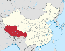 A map of the Tibetan autonomous region (solid red) and Northern Arunachal Pradesh/South Tibet (striped red)
The Arunachal Pradesh dispute is a territorial dispute over the region located on the middle of the Yarlung Zangbo River, 300 km north of the Himalayas.[1] It is entirely administered by India as part of its Arunachal Pradesh state; China claims it as a part of its Tibet Autonomous Region and refers to it as 'South Tibet' (Chinese: 藏南; pinyin: Zàngnán).[2][3][4] In particular, China contests the legitimacy of the 1914 Simla Accord with the British Empire for multiple reasons. China claims the region where Tawang sits and the area surrounding it as a southern extension of Tibet, which Beijing rules; India has long maintained that the land, which comprises its northeastern state of Arunachal Pradesh, is an inalienable part of its territory.[5] The main ethnic group in South Tibet, the Monpa people, are culturally, linguistically, and ethnically similar, but not identical, to the Tibetan people.[6][7] The Monpa dialects belong to the Tibeto-Burman language group.[8]
Contents
Dispute
The focus of the long-standing unresolved border dispute is under the administration of India as part of the Northeast Indian state of Arunachal Pradesh. The area is claimed by China[9] as part of its Tibet Autonomous Region, and in 2007, it denied a visa to an official from the disputed part of Arunachal Pradesh, on the basis that the official was already a citizen of China.[10] [11]
A 1914 conference to determine the status of Tibet, the Simla Accord, was attended by representatives of Britain, China, and the local Tibetan government.[12] However China only had observer status in the negotiations.[13] The Chinese representative rejected British designs for Tibet, including its division into "inner" and "outer" Tibet, with the withdrawal of Chinese administration in the latter, so the negotiations broke down.[14] The Chinese government further announced that it would not recognize "any bilateral agreement between Tibet and the British Government", repudiating the actions of any Chinese representatives that could be construed as recognition of such agreements. Nonetheless, British and Tibetan representatives, secretly and separately from Simla, negotiated the northeast Indian border in Delhi, and the Tibetan representative reluctantly agreed to cede the disputed territory. They later presented this as an extended interpretation of the line drawn on the Simla map,[7] and declared the convention binding on themselves.[14] China regarded this joint declaration as illegal, maintaining that Tibet did not have treaty-making powers according to the Anglo-Chinese Agreement of 1906 and the Anglo-Russian Convention of 1907. Survey of India maps began to reflect the McMahon line as the northern border of British India from 1937, but South Tibet remained under de facto Tibetan control until 1947, when the British established outposts in Dirang Dzong for protection against the Empire of Japan during World War II.[7]
After his exile, the 14th Dalai Lama argued that India's use of the Simla border means that India considered Tibet independent.[15]
The Dalai Lama's opinion
The 14th Dalai Lama, who led the Tibetan government from 1950 to 1959, said as recently as 2003 that Tawang is "actually part of Tibet".[16] He reversed his position in 2008, saying that it was part of India.[16]
Description
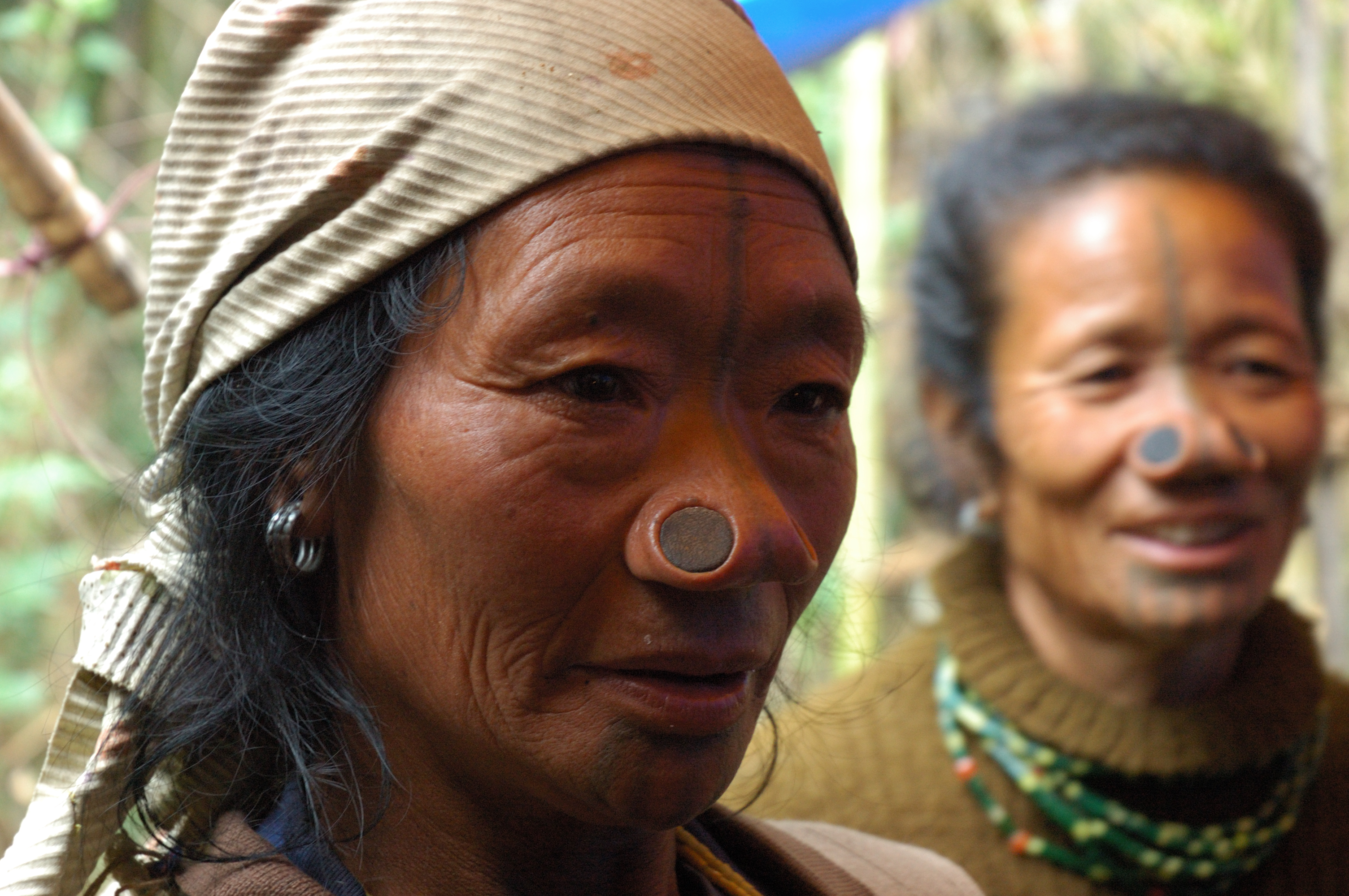
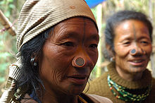 Tanii Lhoba people (珞巴族登尼部) in South Tibet
The disputed territory includes the Yarlung Tsangpo Canyon, formed by the middle reaches of the Yarlung Tsangpo River in the south of the Tibet Autonomous Region. It stretches 1200 kilometres from Mainling in the east to Saga (Tibetan: ས་དགའ་རྫོང་, Wylie: sa dga’ rdzong; Chinese: 萨嘎县; pinyin: Sàgā Xiàn) in the west, and some 300 kilometres from the Himalaya range in the south to the Gangdisê (Kangrinboqê) and Nyainqêntanglha massifs in the north. The bottom of the valley ascends from an altitude of 2800 metres in the east to 4500 metres in the west.[17][18] The Gangdisê and Nyainqêntanglha mountain ranges (sometimes referred to as "Trans-Himalaya") separates the region from the Tibetan (Chinese: 藏北; pinyin: Zàngběi)[citation needed] territories in China.
The region includes the following geological areas: the Tibetan Plateau and the Yunnan-Guizhou Plateau. Politically, China considers it to be a part of the Autonomous regions of China divisions of Xigazê, Shannan and Nyingchi while India considers it to be a part of its Arunachal Pradesh state. All or parts of these areas are disputed areas claimed by four parties: the People's Republic of China, the Republic of China, the Tibetan Government in Exile, and India.
In the south-east, part of South Tibet is claimed by China, but controlled by India. China views these areas as parts of the counties Mêdog and Zayü in Nyingchi, parts of Cona and the south of Lhünzê in Shannan. This is the area south of the McMahon Line, which is not recognised by China as an international border.
See also
References
- ^ http://www.globalsecurity.org/military/world/war/india-china_conflicts.htm
- ^ "India and China on parade". Asia Tim. August 1 2007. http://www.atimes.com/atimes/South_Asia/IH01Df02.html. Retrieved 2007-08-25.
- ^ "Tibet – China – India - Tibetans and Indians rally against 60 years of Chinese violence". Asia News. http://www.asianews.it/index.php?l=en&art=16471&size=A. Retrieved 2009-10-01.
- ^ "China Bans Foreign Tourists From Tibet". NYTimes.com. http://www.nytimes.com/aponline/2009/09/22/world/AP-AS-China-Tibet-Tourism.html. Retrieved 2009-10-01.[dead link]
- ^ "Beyond India vs. China: The Dalai Lama's Agenda". TIME. 2009-11-05. http://www.time.com/time/world/article/0,8599,1934948,00.html.
- ^ Dorje, Gyurme (1999). Footprint Tibet Handbook. Footprint Books. p. 684.
- ^ a b c Ray, Jayanta Kumar (2007). Aspects of India's International relations, 1700 to 2000: South Asia and the World. History of science, philosophy, and culture in Indian civilization: Towards independence. Pearson PLC. pp. 202–204. ISBN 9788131708347.
- ^ Lewis, Paul M. (2009). Ethnologue: Languages of the World, sixteenth edition. SIL International. http://www.ethnologue.com/show_language.asp?code=twm.
- ^ "Arunachal Pradesh Territorial Dispute between India and China". www.american.edu. November 2005. http://www.american.edu/ted/ice/india-china.htm. Retrieved 2007-08-25.
- ^ "China denies visa to IAS officer from Arunachal". The Financial Express. 2007-05-26. http://www.financialexpress.com/news/china-denies-visa-to-ias-officer-from-arunachal/200132/. Retrieved 2011-07-09.
- ^ "Chinese Chequers Don't Simply Hope For The Best, Match Beijing Move For Move". Tibetan Parliamentary & Policy Research Centre. June 10 2007. http://www.tpprc.org/news/2007/2007.6.12-chinese-chequers.html. Retrieved 2007-08-26.[dead link]
- ^ "Conven1914"
- ^ "A Himalayan rivalry". The Economist. 19 August 2010. http://www.economist.com/node/16843717?story_id=16843717. Retrieved 25 August 2010.
- ^ a b Goldstein, Melvyn C. (1991). A history of modern Tibet, 1913-1951: the demise of the Lamaist state. University of California Press. ISBN 9780520075900. http://books.google.com/books?id=Upwq0I-wm7YC&pg=PA80.
- ^ "The Bobber". Time Magazine. September 21 1959. http://www.time.com/time/magazine/article/0,9171,869211,00.html?promoid=googlep. Retrieved 2007-08-26.
- ^ a b "Tawang is part of India: Dalai Lama". TNN. 4 June 2008. http://timesofindia.indiatimes.com/India/Tawang_is_part_of_India_Dalai_Lama_/articleshow/3097568.cms. Retrieved 4 June 2008.
- ^ Yang Qinye and Zheng Du. Tibetan Geography. China Intercontinental Press. pp. 30–31. ISBN 7508506650. http://books.google.com/books?id=4q_XoMACOxkC&pg=PA30&ots=SPF7WPsv8p&dq=%22South+Tibet+Valley%22&ie=ISO-8859-1&output=html&sig=cQUrmaN5XEoHuoEIcfs8aJpkKEY.
- ^ Zheng Du, Zhang Qingsong, Wu Shaohong: Mountain Geoecology and Sustainable Development of the Tibetan Plateau (Kluwer 2000), ISBN 0-7923-6688-3, p. 312;
External links
- Tibet Facts and Figures 2005
- Knitting women in south Tibet
- Position of the Lhasa block, South Tibet, during the late Cretaceous
- His Holiness Gyalwang Karmapa concludes 25-day visit to the South Tibetan Settlements
Territorial disputes in East, South, and Southeast Asia Type Territory Currently administered by Claimants Land: Aksai Chin People's Republic of China People's Republic of China, Republic of China1, India Baekdu/Changbai Mountain North Korea, People's Republic of China North Korea, South Korea, People's Republic of China, Republic of China Heixiazi / Bolshoy Ussuriysky (Eastern part)1 People's Republic of China, Russia Republic of China1 Indo-Bangladesh enclaves2 Bangladesh, India Bangladesh, India Kachin State Burma, Burma, Republic of China1 Kashmir2 India, Pakistan India, Pakistan Korean Peninsula and its adjacent islands South Korea, North Korea South Korea, North Korea Mainland China People's Republic of China People's Republic of China, Republic of China North Borneo (Sabah)1 Malaysia Malaysia, Philippines Pamir Mountains2 Afghanistan, Tajikistan Afghanistan, Republic of China1, Tajikistan Sixty-Four Villages East of the River1 Russia Republic of China1, Russia South Tibet India People's Republic of China, Republic of China1, India Tannu Uriankhai (now Tuva Republic of Russia)1 Russia Republic of China1, Russia Trans-Karakoram Tract People's Republic of China People's Republic of China, Republic of China1, India Islands and waters: Diaoyutai / Senkaku Islands Japan People's Republic of China, Republic of China, Japan Kinmen Republic of China People's Republic of China, Republic of China Kori Creek1 India, Pakistan India, Pakistan Liancourt Rocks South Korea South Korea, North Korea1, Japan Macclesfield Bank People's Republic of China, Republic of China, Philippines Matsu Republic of China People's Republic of China, Republic of China Paracel Islands People's Republic of China People's Republic of China, Republic of China, Vietnam Pedra Branca, Middle Rocks, and South Ledge Singapore Malaysia, Singapore Pratas Islands Republic of China People's Republic of China, Republic of China Scarborough Shoal Philippines People's Republic of China, Republic of China, Philippines Socotra Rock South Korea South Korea, People's Republic of China1 Southern Kuril Islands Russia Russia, Japan Spratly Islands2 People's Republic of China, Republic of China, Malaysia, Philippines, Vietnam Brunei, People's Republic of China, Republic of China, Malaysia, Philippines, Vietnam Taiwan and Penghu1 Republic of China People's Republic of China, Republic of China Notes: 1Inactive dispute.
2Divided among multiple claimants.Categories:- Tibet Autonomous Region
- Arunachal Pradesh
- Territorial disputes of the People's Republic of China
- Territorial disputes of India


Wikimedia Foundation. 2010.