- Lundy
-
This article is about the island of Lundy, which is part of England. For other uses, see Lundy (disambiguation).
Lundy Site of Special Scientific Interest 
Area of Search Devon Grid reference SS135460 Interest Biological Area 445 ha (1,100 acres) or
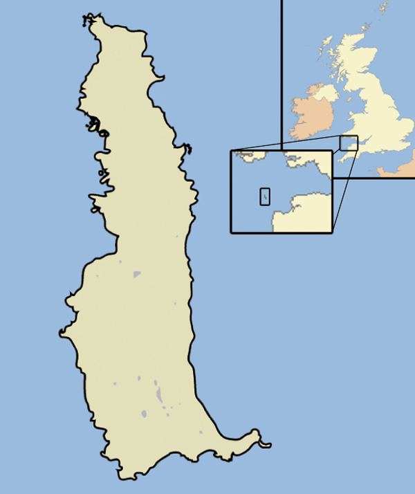
4.45 km2 (1.72 sq mi) [1][2]Notification 1987 Location map English Nature Lundy is the largest island in the Bristol Channel, lying 12 miles (19 km) off the coast of Devon, England, approximately one third of the distance across the channel between England and Wales. It measures about 3 by 0.75 miles (4.8 by 1.2 km) at its widest.[3] Lundy gives its name to a British sea area and is one of the islands of England.[4]
As of 2007, there was a resident population of 28 people, including volunteers. These include a warden, ranger, island manager, and farmer, as well as bar and house-keeping staff. Most live in and around the village at the south of the island. Most visitors are day-trippers, although there are 23 holiday properties and a camp site for staying visitors, mostly also around the south of the island.
In a 2005 opinion poll of Radio Times readers, Lundy was named as Britain's tenth greatest natural wonder. The entire island has been designated as a Site of Special Scientific Interest[5] and it was England's first statutory Marine Nature Reserve, and the first Marine Conservation Zone,[6] because of its unique flora and fauna. It is managed by the Landmark Trust on behalf of the National Trust.
Contents
History
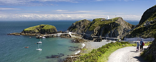 Lundy's jetty and harbour
The name Lundy is believed to come from the old Norse word for "puffin island" (Lundey), lundi being the Norse word for a puffin and ey, an island,[7] although an alternative explanation has been suggested with Lund referring to a copse, or wooded area.[8] According to genealogist Edward MacLysaght the surname Lundy is from Norman de la Lounde, a name recorded in medieval documents in counties Tipperary and Kilkenny in Ireland.[9][clarification needed]
Lundy has evidence of visitation or occupation from the Neolithic period onward, with Mesolithic flintwork, Bronze Age burial mounds, four inscribed gravestones from the early medieval period,[10][11] and an early medieval monastery (possibly dedicated to St Elen or St Helen).
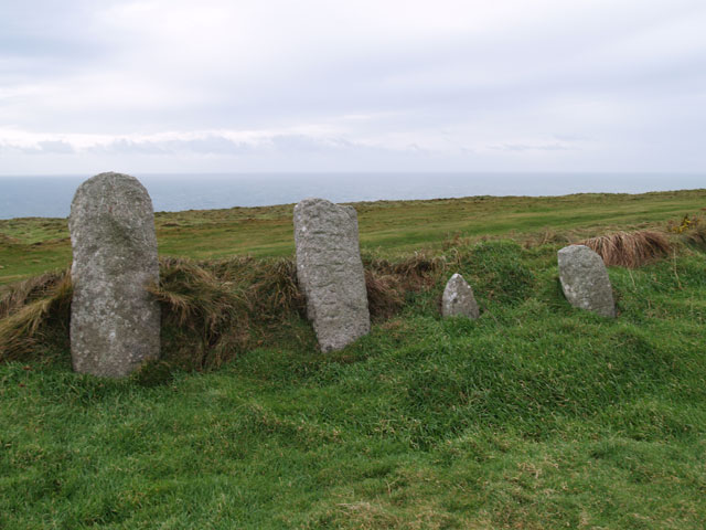
Beacon Hill Cemetery
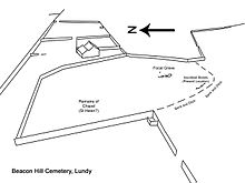 Sketch of Beacon Hill cemetery
Beacon Hill cemetery was excavated by Charles Thomas in 1969.[12] The cemetery contains four inscribed stones, dated to the 5th or 6th century AD. The site was originally enclosed by a curvilinear bank and ditch, which is still visible in the south west corner. However, the other walls were moved when the Old Light was constructed in 1819. Early Christian enclosures of this type are known as lanns in Cornish. There are surviving examples in Luxulyan, in Cornwall; Mathry, Mydrim, and Clydey in Wales; and Stowford, Jacobstowe, Lydford, and Instow, in Devon.
Thomas proposed a five-stage sequence of site usage: (1) An area of round huts and fields. These huts may have fallen into disuse before the construction of the cemetery. (2) The construction of the focal grave, an 11 ft by 8 ft rectangular stone enclosure containing a single cist grave. The interior of the enclosure was filled with small granite pieces. Two more cist graves located to the west of the enclosure may also date from this time. (3) Perhaps 100 years later, the focal grave was opened and the infill removed. The body may have been moved to a church at this time. (4) & (5) Two further stages of cist grave construction around the focal grave.
23 cist graves were found during this excavation. Considering that the excavation only uncovered a small area of the cemetery, there may be as many as 100 graves.
Inscribed stones
 Inscribed stones
Four Celtic inscribed stones have been found in Beacon Hill cemetery:
- 1400 OPTIMI,[12] or TIMI;[13] the name Optimus is Latin and male. Discovered in 1962 by D. B. Hague.[14]
- 1401 RESTEVTAE,[12] or RESGEVT[A],[13] Latin, female i.e. Resteuta or Resgeuta. Discovered in 1962 by D. B. Hague.[14]
- 1402 POTIT[I],[12] or [PO]TIT,[13] Latin, male. Discovered in 1961 by K. S. Gardener and A. Langham.[14]
- 1403 --]IGERNI [FIL]I TIGERNI,[12] or—I]GERNI [FILI] [T]I[G]ERNI,[13] Brittonic, male i.e. Tigernus son of Tigernus. Discovered in 1905.[14]
Knights Templar
Lundy was granted to the Knights Templar by Henry II in 1160. The Templars were a major international maritime force at this time, with interests in North Devon, and almost certainly an important port at Bideford or on the River Taw in Barnstaple. This was probably because of the increasing threat posed by the Norse sea raiders; however, it is unclear whether they ever took possession of the island. Ownership was disputed by the Marisco family who may have already been on the island during King Stephen's reign. The Mariscos were fined, and the island was cut off from necessary supplies.[15] Evidence of the Templars' weak hold on the island came when King John, on his accession in 1199, confirmed the earlier grant.[16]
Marisco family
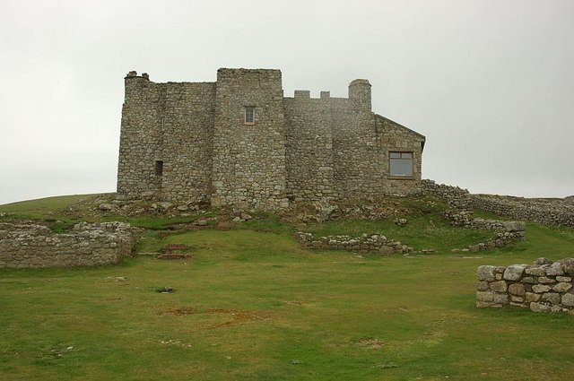
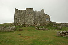 Marisco Castle
In 1235 William de Marisco was implicated in the murder of Henry Clement, a messenger of Henry III.[17] Three years later, an attempt was made to kill Henry III by a man who later confessed to being an agent of the Marisco family. William de Marisco fled to Lundy where he lived as a virtual king. He built a stronghold in the area now known as Bulls' Paradise with 9 feet (3 m) thick walls.[16] In 1242, Henry III sent troops to the island. They scaled the island's cliff and captured William de Marisco and 16 of his "subjects". Henry III built the castle (sometimes erroneously referred to as the Marisco Castle) in an attempt to establish the rule of law on the island and its surrounding waters.[18]
Piracy
But the island was hard to govern. Over the next few centuries, trouble followed as both English and foreign pirates and privateers – including other members of the Marisco family – took control of the island for short periods. Ships were forced to navigate close to Lundy because of the dangerous shingle banks in the fast flowing River Severn and Bristol Channel, with its 32 feet (10 m) tide, the second highest in the world.[19][20] This made the island a profitable location from which to prey on passing Bristol-bound merchant ships bringing back valuable goods from overseas.[21]
In 1627 Barbary Pirates from the Republic of Salé occupied Lundy for five years. The North African invaders, under the command of Dutch renegade Jan Janszoon, flew an Ottoman flag over the island. Some captured Europeans were held on Lundy before being sent to Algiers as slaves.[22][23][24] From 1628 to 1634 the island was plagued by pirate ships of French, Basque, English, and Spanish origin. These incursions were eventually ended by Sir John Pennington, but in the 1660s and as late as the 1700s the island still fell prey to French privateers.[25]
Civil war
In the English Civil War, Thomas Bushell held Lundy for King Charles I, rebuilding Marisco Castle and garrisoning the island at his own expense. He was a friend of Francis Bacon, a strong supporter of the Royalist cause and an expert on mining and coining. This was the last part of the Royalist lands to capitulate to the Parliament forces, and only after a year-long siege. Richard Fiennes, representing General Fairfax, received the surrender.[26]
In 1656, the island was acquired by Lord Saye and Sele.[27]
 The Old Light
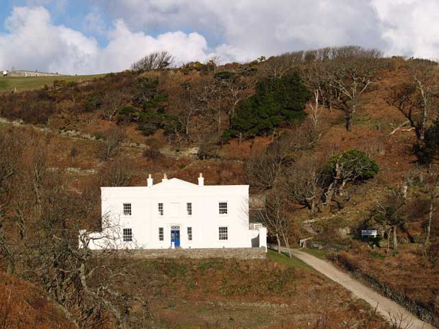
 Millcombe House
 Interior of St.Helena's Church
18th and 19th centuries
The late 18th and early 19th centuries were years of lawlessness on Lundy, particularly during the ownership of Thomas Benson, a Member of Parliament for Barnstaple in 1747 and Sheriff of Devon, who notoriously used the island for housing convicts whom he was supposed to be deporting. Benson leased Lundy from its owner, Lord Gower, at a rent of £60 per annum and contracted with the Government to transport a shipload of convicts to Virginia, but diverted the ship to Lundy to use the convicts as his personal slaves. Later Benson was involved in an insurance swindle. He purchased and insured the ship Nightingale and loaded it with a valuable cargo of pewter and linen. Having cleared the port on the mainland, the ship put into Lundy, where the cargo was removed and stored in a cave built by the convicts, before setting sail again. Some days afterwards, when a homeward-bound vessel was sighted, the Nightingale was set on fire and scuttled. The crew were taken off the stricken ship by the other ship, which landed them safely at Clovelly.[28]
Sir Aubrey Vere Hunt of Curragh Chase purchased the island from John Cleveland in 1802 for £5,270. Sir Vere Hunt planted in the island a small, self-contained Irish colony with its own constitution and divorce laws, coinage and stamps. He failed in his attempt to sell the Island to the British Government as a base for troops, and his son Sir Aubrey Thomas De Vere also had great difficult in securing any profit from the property. The tenants came from Sir Vere Hunt's Irish estate and they experienced agricultural difficulties while on the island. This led Sir Vere Hunt to seek someone who would take the island off his hands. In the 1820s John Benison agreed to purchase the Island for £4,500 but then refused to complete sale as he felt that that Aubrey could not make out a good title in respect of the sale terms, namely that the Island was free from tithes and taxes.[29]
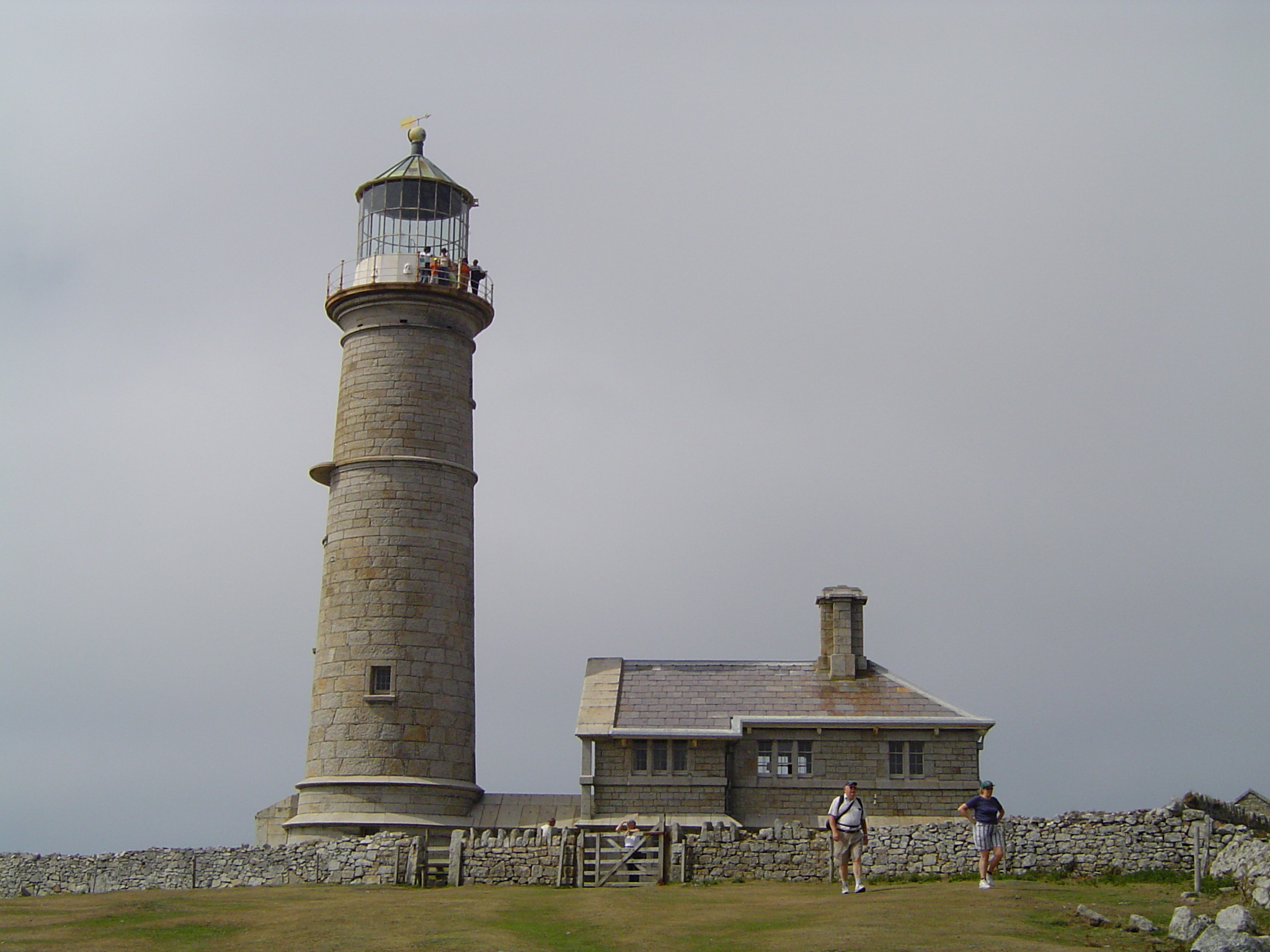
Foundations for the first lighthouse were laid in 1787 but the lighthouse was not built until Trinity House obtained a 999-year lease in 1819. The 97 feet (30 m) tower, on the summit of Chapel Hill, was designed by Daniel Asher Alexander and built by Joseph Nelson at a cost of £36,000.[30] Because the site is 407 feet (124 m) above sea level, the highest base for a lighthouse in Britain, the fog problem was not solved and the Fog Signal Battery[31] was built about 1861. The lighthouse had two lights, however they revolved so quickly that they gave the impression it was a fixed light with no flashes detectable. These may have contributed to the grounding, at Cefn Sidan, of the La Jeune Emma, bound from Martinique to Cherbourg in 1828. 13 of the 19 on board drowned, including Adeline Coquelin, the 12 year-old niece of Napoleon Bonaparte's divorced wife Josephine de Beauharnais.[32] Eventually the lighthouse was abandoned in 1897 when the North[33] and South[34] Lundy lighthouses were built. The Old Light and the associated keeper's houses are kept open by the Landmark Trust.[35]
William Hudson Heaven purchased Lundy in 1834, as a summer retreat and for the shooting, at a cost of 9,400 guineas (£9,870). He claimed it to be a "free island", and successfully resisted the jurisdiction of the mainland magistrates. Lundy was in consequence sometimes referred to as "the kingdom of Heaven". It belongs in fact to the county of Devon, and has always been part of the hundred of Braunton.[27] Many of the buildings on the island today, including St. Helena's Church and Millcombe House (originally known simply as The Villa), date from the Heaven period. The Georgian-style Villa was built in 1836.[36] However, the expense of building the road from the beach (no financial assistance being provided by Trinity House, despite their regular use of the road following the construction of the lighthouses), the Villa and the general cost of running the island had a ruinous effect on the family's finances, which had been damaged by reduced profits from their sugar plantations in Jamaica.
In 1957 a message in a bottle from one of the seamen of the HMS Caledonia was washed ashore between Babbacombe and Peppercombe in Devon. The letter, dated August 15, 1843 read: "Dear Brother, Please e God i be with y against Michaelmas. Prepare y search Lundy for y Jenny ivories. Adiue William, Odessa". The bottle and letter are on display at the Portledge Hotel at Fairy Cross, in Devon, England. The Jenny was a three-masted schooner reputed to be carrying ivory and gold dust that was wrecked on Lundy (at a place thereafter called Jenny's Cove) on February 20, 1797. The ivory was apparently recovered some years later but the leather bags supposed to contain gold dust were never found.[37][38]
Lighthouses
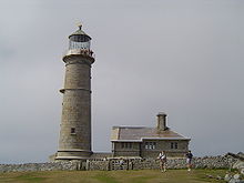
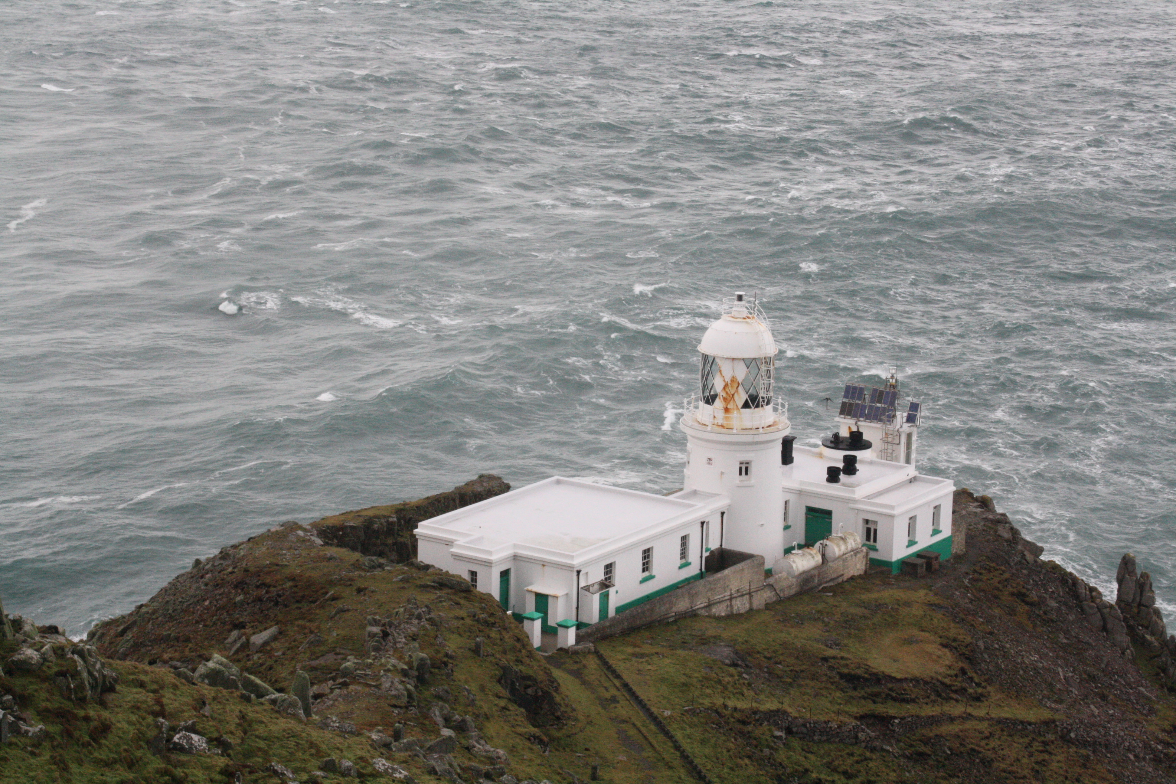
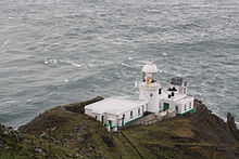 North lighthouse
The north and south lighthouses were built in 1897, to take over from the old lighthouse. The north lighthouse is 17 metres tall—slightly taller than the south one; they are painted white and were automated in 1991 and 1994. The south lighthouse has a focal length of 53 metres (174 ft) and a quick white flash every 15 seconds.[35] It can be seen as a small white dot from Hartland Point, 11 miles to the south east. It was automated and converted to solar power in 1994.[32] Both lighthouses are run and maintained by Trinity House.[39] The northern light, which has a focal plane of 48 metres (157 ft) and produces a quick white flash every 5 seconds,[35] was originally lit by a 75mm petroleum vapour burner and oil was lifted up from a small quay using a sled and winch, and then transported using a small railway (again winch-powered). The remains of this can be still seen, but it was abandoned in 1971 and the lighthouses use a discharge bulb fed from the island's main supply.[39] In 1985 the northern light was modernised six years later and was converted to solar power.[32]
20th and 21st centuries
William Heaven was succeeded by his son the Reverend Hudson Grosset Heaven who, thanks to a legacy from Sarah Langworthy (née Heaven), was able to fulfill his life's ambition of building a stone church on the island. St Helena's was completed in 1896, and stands today as a lasting memorial to the Heaven period. It has been designated by English Heritage a Grade II listed building.[40] He is said to have been able to afford either a church or a new harbour. His choice of the church was not however in the best financial interests of the island. The unavailability of the money for re-establishing the family's financial soundness, coupled with disastrous investment and speculation in the early 20th century, caused severe financial hardship.[citation needed]
 One Puffin coin of 1929, bearing the portrait of Martin Coles Harman
Hudson Heaven died in 1916, and was succeeded by his nephew, Walter Charles Hudson Heaven.[41] With the outbreak of World War I, matters deteriorated seriously, and in 1918 the family sold Lundy to Augustus Langham Christie. In 1924, the Christie family sold the island along with the mail contract and the MV Lerina to Martin Coles Harman, who proclaimed himself a king. Harman issued two coins of Half Puffin and One Puffin denominations in 1929, nominally equivalent to the British halfpenny and penny, resulting in his prosecution under the United Kingdom's Coinage Act of 1870. The House of Lords found him guilty in 1931, and he was fined £5 with fifteen guineas expenses. The coins were withdrawn and became collectors' items. In 1965 a "fantasy" restrike four-coin set, a few in gold, was issued to commemorate 40 years since Harman purchased the island.[42] Harman's son, John Pennington Harman was awarded a posthumous Victoria Cross in Kohima, India in 1944. There is a memorial to him at the VC Quarry on Lundy. Martin Coles Harman died in 1954.
Residents did not pay taxes to the United Kingdom and had to pass through customs when they travelled to and from Lundy Island. Although the island was ruled as a virtual fiefdom, its owner never claimed to be independent of the United Kingdom, in contrast to later territorial "micronations".
Following the death of Harman's son Albion in 1968,[43] Lundy was put up for sale in 1969. Jack Hayward, a British millionaire, purchased the island for £150,000 and gave it to the National Trust,[42] who leased it to the Landmark Trust. The Landmark Trust has managed the island since then, deriving its income from arranging day trips, letting out holiday cottages and from donations.
The island is visited by over 20,000 day-trippers a year, but during September 2007 had to be closed for several weeks owing to an outbreak of Norovirus.[44]
Wreck of Battleship Montagu

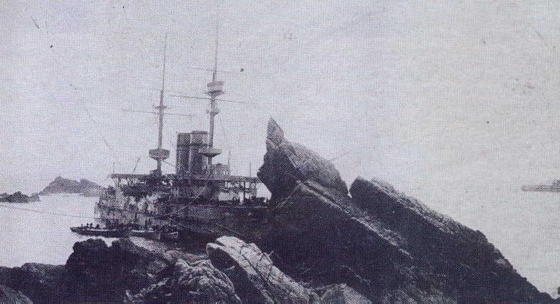
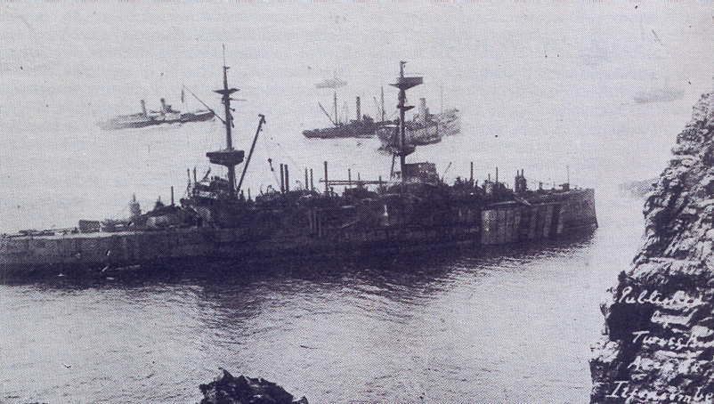
A naval footnote in the history of Lundy was the wreck of the Royal Navy battleship HMS Montagu. Steaming in heavy fog, she ran hard aground near Shutter Rock on the island's southwest corner at about 2:00 a.m. on May 30, 1906.[45] Thinking they were aground at Hartland Point on the English mainland, a landing party went ashore for help, only finding out where they were after encountering the lighthouse keeper at the island's north light.
 HMS Montagu during the failed salvage attempts of the summer of 1906
Strenuous efforts by the Royal Navy to salvage the badly damaged battleship during the summer of 1906 failed, and in 1907 it was decided to give up and sell her for scrap. Montagu was scrapped at the scene over the next fifteen years. Diving clubs still visit the site, where armour plate and live 12-inch (305-millimetre) shells remain on the seabed.
Remains of a German Heinkel 111H bomber
During World War II two German Heinkel He 111 bombers crash landed on the island in 1941. The first was on 3 March, when all the crew survived and were taken prisoner. The second was on 1 April when the pilot was killed and the other crew members were taken prisoner.[46] The plane had bombed a British ship and one engine damaged by anti aircraft fire, forcing it to crash land. A few remains can be found on the crash site. Reportedly to avoid reprisals the crew concocted a story that they were on a reconnaissance mission.[47]
Geography
 Lundy Granite
Lundy is located at 51°10′37.8876″N 4°39′57.96″W / 51.177191°N 4.6661°W (51.177191, 4.6661).[48] It is 3 miles (5 km) long from north to south by about 0.75 miles (1.2 km) wide, with an area of 445 hectares (1.72 sq mi).[1][2] The highest point on Lundy is at 142 metres (466 ft). A few metres off the northeastern coast is Seal's Rock which is so called after the seals which rest on and inhabit the islet. [49][50] It is less than 50 metres (55 yd) wide.[51]
Geology
The island is primarily composed of granite of 50±3 to 54±2 million years[52] (from the Eocene period), with slate at the southern end; the plateau soil is mainly loam, with some peat.[5][53] Among the igneous dykes cutting the granite are a small number composed of a unique orthophyre. This was given the name Lundyite in 1914, although the term – never precisely defined – has since fallen into disuse.[54]
Climate
Lundy Island lies on the borderline where the North Atlantic Ocean and the Bristol Channel meet, so it has quite a mild climate. Lundy has cool, wet winters and mild, wet summers. It is often windy on the coast.
Ecology
Flora

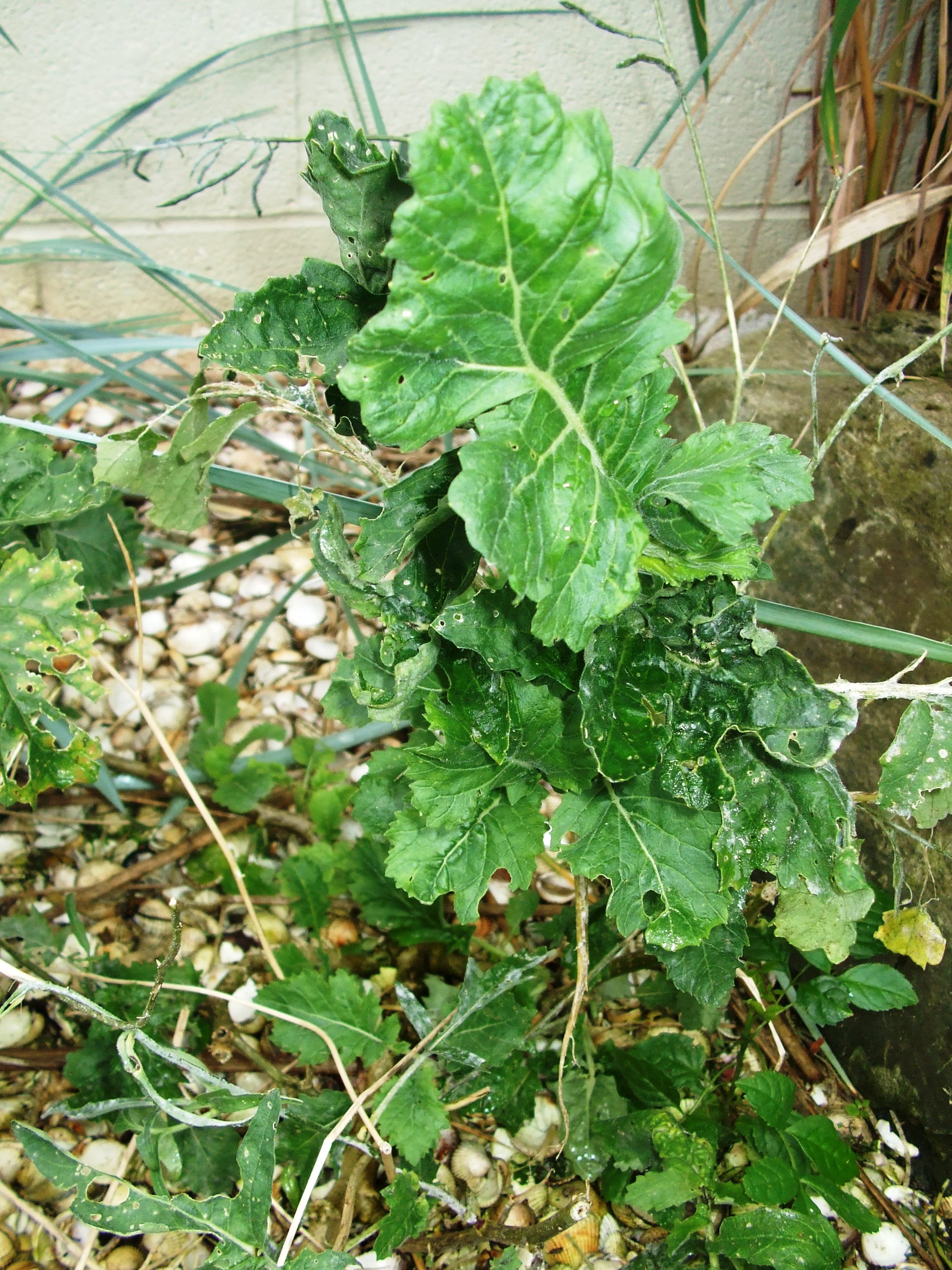
There is one endemic plant species, the Lundy Cabbage (Coincya wrightii), a species of primitive brassica.[55]
By the 1980s the eastern side of the island had become overgrown by rhododendrons (Rhododendron ponticum) which had spread from a few specimens planted in the garden of Millcombe House in Victorian times, but eradication of this non-native plant has been undertaken by volunteers over the past fifteen years in an operation known on the island as "rhody-bashing", which it is hoped will be completed by 2012. The vegetation on the plateau is mainly dry heath, with an area of waved Calluna heath towards the northern end of the island, which is also rich in lichens, such as Teloschistes flavicans and several species of Cladonia and Parmelia. Other areas are either a dry heath/acidic grassland mosaic, characterised by heaths and Western Gorse (Ulex gallii), or semi-improved acidic grassland in which Yorkshire Fog (Holcus lanatus) is abundant. Tussocky (Thrift) (Holcus/Armeria) communities occur mainly on the western side, and some patches of Bracken (Pteridium aquilinum) on the eastern side.[5]
Fauna
Until 2006 the Lundy Cabbage was thought to support two endemic species of beetle. The beetles are now known not to be unique to Lundy, but an endemic weevil, the Lundy cabbage flea beetle, (Psylliodes luridipennis) has been discovered. The island is also home to the purseweb spider (Atypus affinis), the only British member of the bird-eating spider family.[56]
Birds
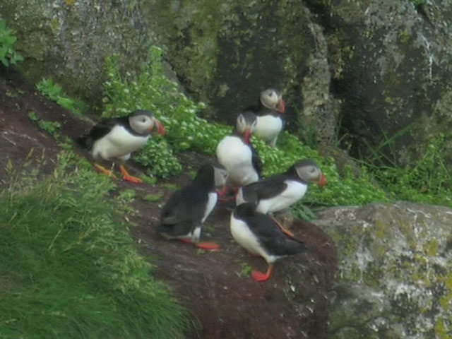
The number of puffins (Fratercula arctica), which may have given the island its name, declined in the late 20th and early 21st centuries, with the 2005 breeding population estimated to be only two or three pairs, as a consequence of depredations by brown and black rats (Rattus rattus) (which have now been eliminated) and possibly also as a result of commercial fishing for sand eels, the puffins' principal prey. Since 2005, the breeding numbers have been slowly increasing. Adults were seen taking fish into four burrows in 2007,[57] and six burrows in 2008.[58]

As an isolated island on major migration routes, Lundy has a rich bird life and is a popular site for birding. Large numbers of Black-legged Kittiwake (Rissa tridactyla) nest on the cliffs, as do Razorbill (Alca torda), Guillemot (Uria aalge), Herring Gull (Larus argentatus), Lesser Black-backed Gull (Larus fuscus), Fulmar (Fulmarus glacialis), Shag (Phalacrocorax aristotelis), Oystercatcher (Haematopus ostralegus), Skylark (Alauda arvensis), Meadow pipit (Anthus pratensis), Common Blackbird (Turdus merula), Robin (Erithacus rubecula) and Linnet (Carduelis cannabina). There are also smaller populations of Peregrine Falcon (Falco peregrinus) and Raven (Corvus corax).
Lundy has attracted many vagrant birds, in particular species from North America. The island's bird list totals 317 species.[59] This has included the following species, each of which represents the sole British record: Ancient Murrelet, Eastern Phoebe and Eastern Towhee. Records of Bimaculated Lark, American Robin and Common Yellowthroat were also firsts for Britain (American Robin has also occurred two further times on Lundy).[59] Veerys in 1987 and 1997 were Britain's second and fourth records, a Rüppell's Warbler in 1979 was Britain's second, an Eastern Bonelli's Warbler in 2004 was Britain's fourth, and a Black-faced Bunting in 2001 Britain's third.[59]
Other British Birds rarities that have been sighted (single records unless otherwise indicated) are: Little Bittern, Glossy Ibis, Gyrfalcon (3 records), Little and Baillon's crakes, Collared Pratincole, Semipalmated (5 records), Least (2 records), White-rumped and Baird's (2 records) sandpipers, Wilson's Phalarope, Laughing Gull, Bridled Tern, Pallas's Sandgrouse, Great Spotted, Black-billed and Yellow-billed (3 records) cuckoos, European Roller, Olive-backed Pipit, Citrine Wagtail, Alpine Accentor, Thrush Nightingale, Red-flanked Bluetail, Black-eared (2 records) and Desert wheatears, White's, Swainson's (3 records), and Grey-cheeked (2 records) thrushes, Sardinian (2 records), Arctic (3 records), Radde's and Western Bonelli's warblers, Isabelline and Lesser Grey shrikes, Red-eyed Vireo (7 records), Two-barred Crossbill, Yellow-rumped and Blackpoll warblers, Yellow-breasted (2 records) and Black-headed (3 records) buntings, Rose-breasted Grosbeak (2 records), Bobolink and Baltimore Oriole (2 records).[59]
Mammals
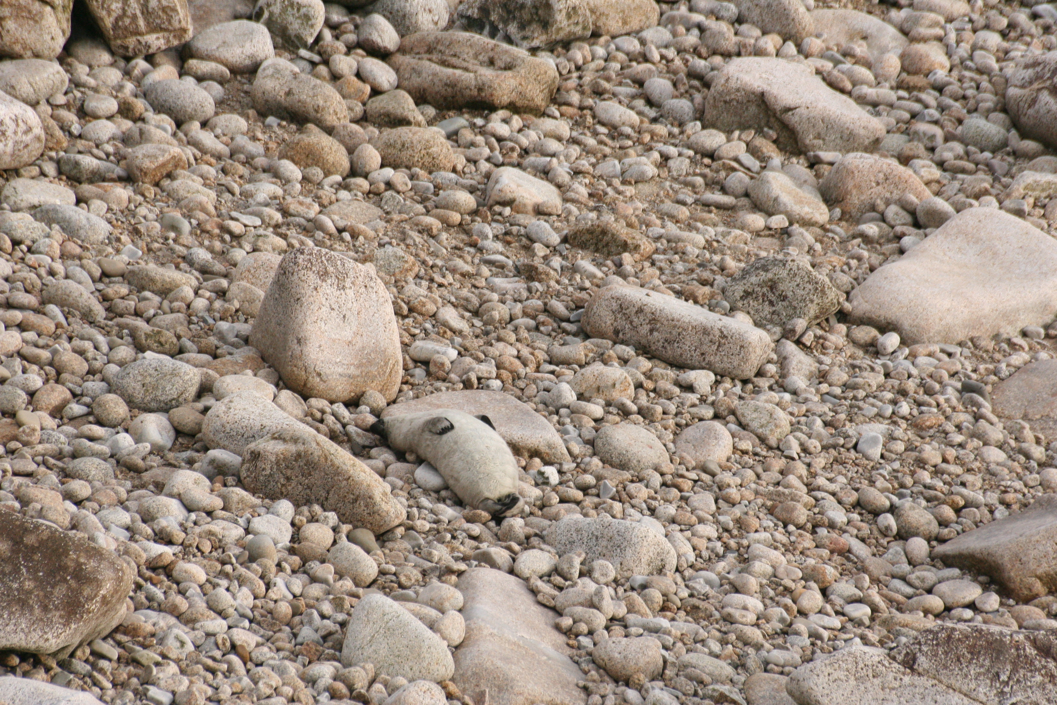
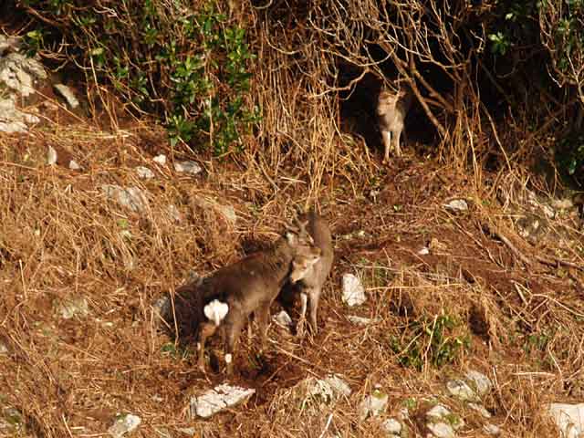
Lundy is home to an unusual range of mammals, almost all introduced, including a distinct breed of wild pony, the Lundy Pony. Until recently, Lundy and the Shiant Isles in the Hebrides were the only two places in the UK where the Black Rat (Rattus rattus) could be found. It has since been eradicated on the island, in order to protect the nesting seabirds. Other species which have made the island their home include the Grey Seal (Halichoerus grypus), Sika Deer (Cervus nippon), Pygmy Shrew (Sorex minutus) and feral goats (Capra aegagrus hircus). Unusually, 20% of the rabbits (Leporidae) on the island are melanistic compared with 4% which is typical in the UK. In mid-2006 the rabbit population was devastated by myxomatosis, leaving only 60 pairs from the previous 15–20,000 individuals. Soay Sheep (Ovis aries) on the island have been shown to vary their behaviours according to nutritional requirements, the distribution of food and the risk of predation.[60]
Marine habitat
In 1971 a proposal was made by the Lundy Field Society to establish a marine reserve. Provision for the establishment of statutory Marine Nature Reserves was included in the Wildlife and Countryside Act 1981, and on 21 November 1986 the Secretary of State for the Environment announced the designation of a statutory reserve at Lundy.[61]
There is an outstanding variety of marine habitats and wildlife, and a large number of rare and unusual species in the waters around Lundy, including some species of seaweed, branching sponges, sea fans and cup corals.[62]
In 2003 the first statutory No Take Zone (NTZ) for marine nature conservation in the UK was set up in the waters to the east of Lundy island.[63] In 2008 this was declared as having been successful in several ways including the increasing size and number of lobsters within the reserve, and potential benefits for other marine wildlife.[64] However, the no take zone has received a mixed reaction from local fishermen.[65]
On 12 January 2010 the island became Britain's first Marine Conservation Zone designated under the Marine and Coastal Access Act 2009, designed to help to preserve important habitats and species.[66][67]
Transport
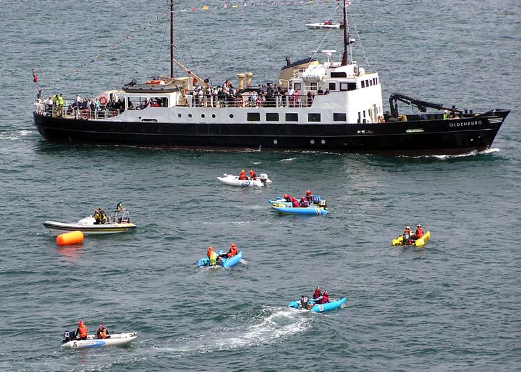
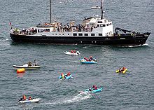 The Lundy ferry Oldenburg sails into Ilfracombe harbour, north Devon, past inflatable ThunderCat powerboats waiting to begin an offshore race.
Two ways exist for getting to Lundy, depending upon the season of travel. During the summer months (April to October) visitors are carried on the Landmark Trust's own vessel, MS Oldenburg, which sails from both Bideford and Ilfracombe. Sailings are usually three days a week, on Tuesdays, Thursdays and Saturdays, with additional sailings on Wednesdays during July and August. The voyage takes on average two hours, depending on ports, tides and weather. The Oldenburg was first registered in Bremen, Germany in 1958 and has been sailing to Lundy since the replacement of her engine in 1985.[68]
During the winter months (November to March), the Oldenburg comes out of service, and the island is served by a scheduled helicopter service from Hartland Point. The helicopter operates on Mondays and Fridays, with flights between 12 noon and 2 pm. The heliport is a field at the top of Hartland Point, not far from the Beacon.
A grass runway of 400 metres (1,312 ft) by 28 metres (92 ft) is available, allowing access to small STOL aircraft skilfully piloted.[69]
Entrance to Lundy is free for anyone arriving by scheduled transport. Visitors arriving by non-scheduled transport are charged a small entrance fee, currently (July 2007) £5.00, with an additional charge payable by those using light aircraft. Anyone arriving on Lundy by non-scheduled transport is also subject to an additional fee for transporting luggage to the top of the island.
In 2007, Derek Green, Lundy's general manager, launched an appeal to raise £250,000 to save the mile-long Beach Road, which had been damaged by heavy rain and high seas. The road was built in the first half of the 19th century to provide people and goods with safe access to the top of the island, 120 metres (394 ft) above the only jetty.[70] The fund-raising was completed on the 10th March 2009.[71]
Kayaking to Lundy
Properly equipped and experienced canoeists can kayak to the island from Hartland Point or Lee Bay. This takes 4 to 6 hours depending on wind and tides.
Electricity supply
There is a small power station comprising three Cummins B and C series diesel engines, offering an approx 150 kVa 3 phase supply to most of the island buildings. Waste heat from the engine jackets is used for a district heating pipe. (cf. cogeneration.) There are also plans to collect the waste heat from the engine exhaust heat gases to feed into the district heat network to improve the efficiency further.[citation needed]
Staying on the island
Lundy has 23 holiday properties to choose from, sleeping between one and 14 people. These include a lighthouse, a castle and a Victorian mansion. Many of the buildings are constructed from the island's granite. All have heating and many also have wood-burning stoves with a bath or shower depending on size. Kitchens are fully equipped for those who prefer self-catering.
The island also has a campsite, at the south of the island in the field next to the shop. It has hot and cold running water, with showers and toilets in an adjacent building.
Administration
The island is an unparished area of Torridge district of the English county of Devon.[72] It belongs to the ward of Clovelly Bay.[73] It is part of the constituency electing the Member of Parliament for Torridge and West Devon and the South West England constituency for the European Parliament.
Stamps
 Lundy stamp of 1929
Owing to a decline in population and lack of interest in the mail contract, the GPO ended its presence at the end of 1927.[74] For the next couple of years "King" Harman handled the mail to and from the island without charge. On 1 November 1929 he decided to offset the expense by issuing a series of private postage stamps, with a value expressed in "Puffins". The printing of Puffin stamps continues to this day. They have to be put on the bottom left hand corner of the envelope, so that the mainland sorting offices can process them: their cost includes the standard Royal Mail charges for onward delivery. Puffins are a type of stamp known to philatelists as a "local carriage label". Issues of increasing value were made over the years, including air mail, featuring a variety of people. Many are now highly sought-after by collectors.[75]
Lundy Island continues to issue stamps with the latest issues being in 2008 (50th birthday of MS Oldenburg) and 2010 (Island wildlife). The value of the early issues has risen substantially over the years. The stamps of Lundy Island serve to cover the postage of letters and cards from the island to the nearest GPO post box on the mainland for the many thousands of annual visitors, and have become part of the collection of the many British Local Posts collectors. These stamps appeared in 1970s in the Rosen Catalogue of British Local Stamps, and in the Phillips Modern British Locals CD Catalogue, published since 2003.[76] There is a comprehensive collection of these stamps in the Chinchen Collection, donated by Barry Chinchen[77] to the British Library Philatelic Collections in 1977 and located at the British Library. This also the home of the Landmark Trust Lundy Island Philatelic Archive which includes artwork, texts and essays as well as postmarking devices and issued stamps.[78]
Labbe's Specialized Guide to Lundy Island Stamps serves as a definitive guide to the issues of Lundy Island including varieties, rarities and special philatelic items.[79]
See also
- Barbara Whitaker, former warden.
- Chinchen Collection
- Puffin Island
References
- ^ a b Devonbirds.org
- ^ a b Devon.gov.uk
- ^ http://getamap.ordnancesurvey.co.uk/getamap/frames.htm (Ordnance Survey maps)
- ^ Collyer, Peter (1998) Rain Later, Good: illustrating the Shipping Forecast. Bradford on Avon: Thomas Reed ISBN 0-901281-33-6
- ^ a b c "Lundy SSSI citation sheet" (PDF). Natural England. http://www.english-nature.org.uk/citation/citation_photo/1001042.pdf. Retrieved 2007-09-05.
- ^ Natural England,News release, 12 January 2009
- ^ "Puffin Island". BBC Radio 4 - The Living World. http://www.bbc.co.uk/radio4/science/livingworld_20040606.shtml. Retrieved 2007-09-05.
- ^ "Meaning of lundey". Pete Robson's Lundy Island Site. http://www.lundypete.com/lundey.htm. Retrieved 2007-09-05.
- ^ Ancestry.com
- ^ See the discussion and bibliography in Elisabeth Okasha, Corpus of early Christian inscribed stones of South-west Britain (Leicester: University Press, 1993), pp. 154-166
- ^ Lundy Field Society 40th Annual Report for 1989. Pp. 34 - 47.
- ^ a b c d e Charles Thomas, And Shall These Mute Stones Speak? (1994) Cardiff: University of Wales Press
- ^ a b c d Elisabeth Okasha, (1993) Corpus of Early Christian Inscribed Stones of South-west Britain. Leicester: University Press
- ^ a b c d "Celtic Inscribed Stones Project history". http://www.ucl.ac.uk/archaeology/cisp/database/. Retrieved 2008-01-06.
- ^ "Lundy Island Pirates — William de Marisco". FairyJo. http://www.fairyjo.info/News/2006/07/26/. Retrieved 2007-09-06.
- ^ a b "Lundy history". Pete Robsons Lundy site. http://www.lundypete.com/history.htm. Retrieved 2007-09-06.
- ^ Maitland, F.W. (April 1895). "The Murder of Henry Clement". The English Historical Review 10 (38): 294–297. doi:10.1093/ehr/X.XXXVIII.294. JSTOR 547790.
- ^ "Marisco Castle, Keep and Bailey". Images of England. http://www.imagesofengland.org.uk/details/default.aspx?id=91981. Retrieved 2007-09-05.
- ^ "Severn Estuary Barrage" (PDF). UK Environment Agency. 31 May 2006. Archived from the original on September 30, 2007. http://web.archive.org/web/20070930155720/http://www.environment-agency.gov.uk/commondata/acrobat/severnpositionmay2006_1508223.pd. Retrieved 2007-09-03.
- ^ "Coast: Bristol Channel". BBC. http://www.bbc.co.uk/bristol/content/articles/2005/07/04/bristolchannel_feature.shtml. Retrieved 2007-08-27.
- ^ "Pirate Island". Rodney Broome. http://web.archive.org/web/20080108121448/http://pages.prodigy.net/rodney.broome/pirlundy.htm. Retrieved 2007-09-06.
- ^ de Bruxelles, Simon (2007-02-28). "Pirates who got away with it". Study of sails on pirate ships (London). http://www.timesonline.co.uk/tol/news/world/africa/article1449736.ece. Retrieved 2007-11-25.
- ^ Konstam, Angus (2008). Piracy: the complete history. Osprey Publishing. p. 91. ISBN 9781846032400. http://books.google.com/books?id=USiyy1ZA-BsC&pg=PA91. Retrieved 2011-04-15.
- ^ Davies, Norman (1996). Europe: A History. Oxford University Press. p. 561. ISBN 9780198201717. http://books.google.com/books?id=jrVW9W9eiYMC&pg=PA561. Retrieved 2007-11-25.
- ^ Chanter, John Roberts (1877). Lundy island: a monograph, descriptive and historical. Cassell, Petter, and Galpin. pp. 78–89. http://books.google.com/books?id=CfkGAAAAQAAJ. Retrieved 2011-08-21.
- ^ Boundy, Wyndham Sydney (1961). Bushell and Harman of Lundy. Bideford: Gazette Printing Service.
- ^ a b "Lundy Community Page". Devon County Libraries. http://www.devon.gov.uk/localstudies/110578/1.html. Retrieved 2007-09-06.
- ^ "Lundy, the Mariscos and Benson.". http://www.lerwill-life.org.uk/history/lundy.htm. Retrieved 2007-09-06.
- ^ "Limerick City Archives, P22, De Vere Papers". http://www.limerickcity.ie/Tools/Search/?cx=011573740689929430170%3Abzoybyvdyy0&cof=FORID%3A9&ie=UTF-8&q=de+vere&sa=Go&siteurl=www.limerick.ie%252FCollectionLists%252FCollectionListsinPDF%252F. Retrieved 2010-06-25.
- ^ "Disused lighthouse and keeper's house.". Images of England. http://www.imagesofengland.org.uk/details/default.aspx?id=91983. Retrieved 2007-09-05.
- ^ "Fog Signal Battery". Images of England. http://www.imagesofengland.org.uk/details/default.aspx?id=91987. Retrieved 2007-09-05.
- ^ a b c "The history of Devon's lighthouses". Local history. BBC Devon. http://www.bbc.co.uk/devon/content/articles/2008/07/10/devon_lighthouses_feature.shtml. Retrieved 9 September 2010.
- ^ "Lundy North Lighthouse incl Engine House and Accom block". Images of England. http://www.imagesofengland.org.uk/details/default.aspx?id=91978. Retrieved 2007-09-05.
- ^ "Lundy South Lighthouse incl. Engine House and Accom block". Images of England. http://www.imagesofengland.org.uk/details/default.aspx?id=91979. Retrieved 2007-09-05.
- ^ a b c Rowlett, Russ. "Lundy Island (Old Light)". University of North Carolina at Chapel Hill. http://www.unc.edu/~rowlett/lighthouse/engsw.htm. Retrieved 9 September 2010.
- ^ "Millcombe House". Images of England. http://www.imagesofengland.org.uk/details/default.aspx?id=91982. Retrieved 2007-09-05.
- ^ Page, John Lloyd Warden, The coasts of Devon and Lundy Island: their towns, villages, scenery, antiquities and legends. London: Horace Cox, 1895, p. 227.
- ^ Langham, A. F. (1994) The island of Lundy. Stroud: Sutton Publishing, p. 142. ISBN 978-0-7509-0661-6
- ^ a b "Lundy North & South Lighthouses". Trinity House. http://www.trinityhouse.co.uk/interactive/gallery/lundy.html. Retrieved 2 May 2010.
- ^ "Church of St Helena". Images of England. http://www.imagesofengland.org.uk/details/default.aspx?id=91976. Retrieved 2007-09-05.
- ^ "Lundy Island". Flags of the World. Archived from the original on January 24, 2005. http://web.archive.org/web/20050124161206/http://www.fotw.net/Flags/gb-en-lu.html. Retrieved 2007-09-06.
- ^ a b Bruce, Colin R. (1988). Unusual World Coins. 2nd. Edition. KP Books. ISBN 0873411161.
- ^ "Island owner dies after air lift" (source unknown). 24 June 1968
- ^ de Bruxelles, Simon (2007-09-21). "Island closes down after stomach bug". Times Online (London). http://www.timesonline.co.uk/tol/news/uk/article2500379.ece. Retrieved 2007-09-29.
- ^ Burt, R. A. (1988). British Battleships 1889-1904. Annapolis, Maryland: Naval Institute Press. pp. 205–206. ISBN 0-87021-061-0.
- ^ Gade, Mary; Michael Harman (1995). Lundy's War. Appledore: Mary Gade. ISBN 978-0952560203.
- ^ "Heinkel He-111 3911 - Lundy". AIRCRAFT WRECKS in the UK & Ireland. http://members.multimania.co.uk/daveswrecks/photoalbum16.html. Retrieved 3 September 2010.
- ^ "US Gazetteer files: 2010, 2000, and 1990". United States Census Bureau. 2011-02-12. http://www.census.gov/geo/www/gazetteer/gazette.html. Retrieved 2011-04-23.
- ^ "LUNDY ISLAND" in A Handbook for Travellers in Devonshire (9th ed.), London, J. Murray, (1879).
- ^ Dive Sites around Lundy at www.lundy.org.uk
- ^ Dive Sites around Lundy at www.lundy.org.uk
- ^ E. A. Edmonds, M. C. McKeown & M. Williams (1975). British Regional Geology, South-West England (4th ed.). British Geological Survey. ISBN 0 11 880713 7.
- ^ "Lundy island, virtual tour — geology". Natural England. http://www.english-nature.org.uk/virtualtours/Lundy/Lundy_geology.htm. Retrieved 2007-09-05.
- ^ Hall, T. C. F. (1915). Summer Programme of the Geological Survey 53 (56).
- ^ "What is a Lundy Cabbage and why is it important?". Lundy.org. http://www.lundy.org.uk/inf/cabbage.html. Retrieved 2007-09-05.
- ^ "Lundy island, virtual tour — wildlife". Natural England. http://www.english-nature.org.uk/virtualtours/Lundy/Lundy_wildlife.htm. Retrieved 2007-09-05.
- ^ Saunders, Nicola (2007 in press): Lundy Warden's Report for 2007 Annual Report of the Lundy Field Society 58
- ^ Saunders, Nicola (personal communication)
- ^ a b c d Davis, Tim & Tim Jones (2007), The Birds of Lundy ISBN 0-954-0088-7-1
- ^ Hopewell, L; R. Rossiter, E. Blower, L. Leaver and K. Goto (September 2005). "Grazing and vigilance by Soay sheep on Lundy island: Influence of group size, terrain and the distribution of vegetation". Behavioural Processes 70 (2): 186–193. doi:10.1016/j.beproc.2005.04.009. PMID 15963661. 10.1016/j.beproc.2005.04.009. http://www.sciencedirect.com/science?_ob=ArticleURL&_udi=B6T2J-4GDBTBR-1&_user=10&_coverDate=09%2F30%2F2005&_rdoc=1&_fmt=&_orig=search&_sort=d&view=c&_acct=C000050221&_version=1&_urlVersion=0&_userid=10&md5=59407c2f2bf7254441a83ec7e5685f22. Retrieved 2007-09-05.
- ^ "Lundy Island Marine Nature Reserve". Lundy.org. http://www.lundy.org.uk/inf/zone.html. Retrieved 2007-09-05.
- ^ "Lundy Marine Nature Reserve". Lundy.org. http://www.lundy.org.uk/inf/mnr.html. Retrieved 2007-09-05.
- ^ "Protection for Lundy Island's sea life boosted: The First No Take Zone in UK confirmed by Government". Press Release. Natural England. http://www.english-nature.org.uk/news/story.asp?ID=444. Retrieved 2008-07-16.
- ^ "Natural England says it’s time to sink or swim to save our seas". Press Release. Natural England. http://www.naturalengland.org.uk/press/releases2008/230108.htm. Retrieved 2008-07-16.[dead link]
- ^ "Fishing ban brings seas to life". BBC News (BBC). 2008-07-16. http://news.bbc.co.uk/1/hi/sci/tech/7508216.stm. Retrieved 2008-07-16.
- ^ "Lundy sea is England's first Maritime Conservation Zone". BBC. 2010-01-12. http://news.bbc.co.uk/1/hi/england/devon/8453202.stm. Retrieved 12 January 2010.
- ^ "Lundy Island becomes England's first marine conservation zone". London: The Guardian. 2010-01-12. http://www.guardian.co.uk/environment/2010/jan/12/lundy-island-marine-conservation-zone. Retrieved 12 January 2010.
- ^ "MS Oldenburg at captainsvoyage". http://captainsvoyage.7.forumer.com/a/ms-oldenburg_post2232.html. Retrieved 2009-06-08.
- ^ UK VFR flight guide, 2003 edition, ISBN 1-874783-624
- ^ Morris, Steven (5 September 2007). "£250,000 plea to save remote island's lifeline". The Guardian (London). http://www.guardian.co.uk/environment/2007/sep/05/3. Retrieved 2007-09-05.
- ^ "Lundy road appeal completed". The Landmark Trust. http://www.landmarktrust.org.uk/news/index.htm#Lundyappealcomplete. Retrieved 2009-03-17.
- ^ "North Devon District Council & Torridge District Council Core Strategy DPDs: Evidence Base". Community Appraisals and Parish Plans in Torridge. North Devon Council. pp. 15–16. http://www.northdevon.gov.uk/core_strategy_evidence_base-2.pdf. Retrieved 27 December 2009.
- ^ "The District of Torridge (Electoral Changes) Order 1999" (PDF). UK Statutory Instruments. http://www.opsi.gov.uk/si/si1999/uksi_19992472_en.pdf. Retrieved 2007-09-05.
- ^ "Lundy Island Postage Stamps". stampingonlundy.co.uk. http://www.stampingonlundy.co.uk/. Retrieved 2007-09-28.
- ^ "Lundy Island Cinderella". King George V Silver Jubilee. http://www.philatel2.com/jubilee/id312.htm. Retrieved 2007-09-28.
- ^ Modern British Locals CD Catalogue, 2009 edition
- ^ Chinchen, Barry N D (1969). A catalogue of Lundy stamps. Eastleigh, Hants.: duplicated by Barry N. D. Chinchen. OCLC 558737398, British Library shelfmark X.512/621
- ^ Philatelic Research at the British Library by David Beech
- ^ Guide to Lundy Island stamps, 2008 edition
Further reading
- Sack, John (2000). Report from Practically Nowhere. ISBN 0-595-08918-6.
- Davis, Tim & Jones, Tim (2007) The Birds of Lundy; illustrated by Mike Langman. Berrynarbor: Devon Bird Watching & Preservation Society and Lundy Field Society, ISBN 0-954-0088-7-1
External links
- Official website
- Lundy Field Society
- Lundy Birds
- Pete Robsons Lundy Island Site
- LundyCam
- Guide to Lundy Island Stamps
- Lundy Marine Reserve at Protect Planet Ocean
- A trip to Devon's 'Puffin Island', Fast Track video feature story about Lundy, 4:15 (2011-09-23)
Coordinates: 51°10′N 4°40′W / 51.167°N 4.667°W
List of micronations Aerican Empire · Aeterna Lucina · Independent State of Aramoana · Atlantium · Avram · Akhzivland · British West Florida · BjornSocialist Republic · Celestia · Christiania · Conch Republic · Copeman Empire · Coral Sea Islands · Elleore · EnenKio · Forvik · Frestonia · Global Country of World Peace · Hajdučka Republika · Hay-on-Wye · Humanity · Hutt River · Kugelmugel · Ladonia · Lagoan Isles · L'Anse-Saint-Jean · Llanrwst · Kingdom of Lovely · Lundy · Marlborough · Melchizedek · Minerva · Molossia · Morac-Songhrati-Meads · Neue Slowenische Kunst · New Utopia · Northern Forest Archipelago · Nova Roma · Other World Kingdom · Perloja · Peščenica · Rainbow Creek · Redonda · Rose Island · Saugeais · Sealand · Seborga · Talossa · Užupis · Valtio · Vikesland · Wanstonia · Waveland · Wendland · Westarctica · Whangamomona · Wirtland
Flags · Currencies · Portal
Categories:- Islands of the Bristol Channel
- Islands of England
- Landmark Trust properties in England
- National Nature Reserves in England
- National Trust properties in Devon
- Nature reserves in Devon
- Failed micronations
- Island countries
- Sites of Special Scientific Interest in Devon
- Sites of Special Scientific Interest notified in 1987
- Special Areas of Conservation in England
- Important Plant Areas in England
- Visitor attractions in Devon
- Ports and harbours of the Bristol Channel
- Barbary pirates
- Invasions of England
- Marine reserves of the United Kingdom


Wikimedia Foundation. 2010.