- Marksville Prehistoric Indian Site
-
Marksville Prehistoric Indian Site
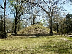
 Burial mound at the site
Location: Avoyelles Parish, Louisiana, USA Nearest city: Marksville, Louisiana Architect: Unknown Governing body: Private NRHP Reference#: 66000372 Significant dates Added to NRHP: October 15, 1966[1] Designated NHL: July 19, 1964[2] Marksville Prehistoric Indian Site, (16 AV 1), also known as Marksville State Historic Site, is a Hopewell tradition earthworks archaeological site in Louisiana, one mile (1.6 km) southeast of Marksville in Avoyelles Parish.
Contents
Description
It the type site for the Marksville culture of prehistoric indigenous peoples of southeastern North America. Centuries later the Avoyel and Natchez tribes lived there until 1700 CE.[3] Burial mounds at the site are surrounded by a horseshoe-shaped earthen embankment about 3,000 feet (910 m) long.
The Marksville Site was the first scientifically excavated site of the Marksville Culture.
Landmark and access
The archaeological site was declared a National Historic Landmark in 1964.[2][4] The site is now also a State Commemorative Area.
The 42-acre (170,000 m2) site is maintained by the state of Louisiana and features a museum with artifacts found at the site and exhibits about the prehistoric people that lived in this Marksville culture area.[5] There are also trails to the mounds and picnic facilities.
See also
- Crooks mound
- Grand Gulf Mound
- List of Hopewell sites
References
- ^ "National Register Information System". National Register of Historic Places. National Park Service. 2007-01-23. http://nrhp.focus.nps.gov/natreg/docs/All_Data.html.
- ^ a b "Marksville Prehistoric Indian Site". National Historic Landmark summary listing. National Park Service. http://tps.cr.nps.gov/nhl/detail.cfm?ResourceId=253&ResourceType=Site. Retrieved 2008-01-04.
- ^ Louisiana Department of Culture, Recreation and Tourism. "Marksville Indian Museum Historical Marker". http://www.stoppingpoints.com/louisiana/Avoyelles/Indian+Museum.html.
- ^ Griffin, John W. (February 28, 1964). National Survey of Historic Sites and Buildings: MarksvillePDF (168 KB). National Park Service. and Accompanying photos, exterior and interior, from 19.PDF (32 KB)
- ^ "Louisiana Prehistory-Marksville, Troyville-Coles Creek, and Caddo". http://www.crt.state.la.us/archaeology/laprehis/marca.htm.
External links
- Marksville State Historic Site - official site
 Hopewellian peoples
Woodland period · List of Hopewell sites · Mound builder (people) · List of archaeological periods (North America) Ohio Hopewell Beam Farm · Benham Mound · Cary Village Site · Cedar-Bank Works · Dunns Pond Mound · Ellis Mounds · Ety Enclosure · Ety Habitation Site · Fort Ancient · Fortified Hill Works · Great Hopewell Road · High Banks Works · Hopeton Earthworks · Hopewell Culture National Historical Park · Indian Mound Cemetery · Keiter Mound · Marietta Earthworks · Moorehead Circle · Mound of Pipes · Nettle Lake Mound Group · Newark Earthworks · Oak Mounds · Perin Village Site · Portsmouth Earthworks · Seip Earthworks and Dill Mounds District · Shawnee Lookout · Tremper Mound and Works · Williamson Mound Archeological District
Crab Orchard culture Goodall Focus Goodall Site · Norton Mound GroupHavana Hopewell culture Kansas City Hopewell Marksville culture Miller culture Point Peninsula Complex Swift Creek culture Etowah Indian Mounds · Leake Mounds · Kolomoki Mounds Historic Park · Miner's Creek site, · Nacoochee Mound · Swift Creek mound site · Yearwood siteOther Hopewellian peoples Armstrong culture · Copena culture · Fourche Maline culture · Laurel Complex · Saugeen Complex · Old Stone Fort (Tennessee)Exotic trade items Related topics · Ancient Monuments of the Mississippi Valley · Black drink · burial mound · Calumet (pipe) · Effigy mound · Hopewell pottery · Horned Serpent · Eastern Agricultural Complex · Underwater panther U.S. National Register of Historic Places Topics Lists by states Alabama • Alaska • Arizona • Arkansas • California • Colorado • Connecticut • Delaware • Florida • Georgia • Hawaii • Idaho • Illinois • Indiana • Iowa • Kansas • Kentucky • Louisiana • Maine • Maryland • Massachusetts • Michigan • Minnesota • Mississippi • Missouri • Montana • Nebraska • Nevada • New Hampshire • New Jersey • New Mexico • New York • North Carolina • North Dakota • Ohio • Oklahoma • Oregon • Pennsylvania • Rhode Island • South Carolina • South Dakota • Tennessee • Texas • Utah • Vermont • Virginia • Washington • West Virginia • Wisconsin • WyomingLists by territories Lists by associated states Other  Category:National Register of Historic Places •
  Portal:National Register of Historic Places
Protected Areas of Louisiana Federal National Marine Sanctuary:Atchafalaya · Bayou Cocodrie · Bayou Sauvage · Bayou Teche · Big Branch Marsh · Black Bayou Lake · Bogue Chitto · Breton · Cameron Prairie · Cat Island · Catahoula · D'Arbonne · Delta · East Cove · Grand Cote · Handy Brake · Lacassine · Lake Ophelia · Mandalay · Red River · Shell Keys · Sabine · Tensas River · Upper Ouachita
State Bayou Segnette · Bogue Chitto · Chemin-A-Haut · Chicot · Cypremort Point · Fairview-Riverside · Fontainebleau · Grand Isle · Hodges Gardens · Jimmie Davis · Lake Bistineau · Lake Bruin · Lake Claiborne · Lake D-Arbonne · Lake Fausse Pointe · North Toledo Bend · Palmetto Island · Poverty Point Reservoir · St. Bernard · Sam Houston Jones · South Toledo Bend · Tickfaw
State Historic SitesAudubon · Centenary · Fort Jesup · Fort Pike · Fort St. Jean Baptiste · Forts Randolph & Buhlow · Locust Grove · Longfellow-Evangeline · Los Adaes · Mansfield · Marksville · Plaquemine Lock · Port Hudson · Poverty Point · Rebel State · Rosedown Plantation · Winter Quarters
State Preservation AreaState ForestsState Wildlife RefugesElmer's Island · Marsh Island · Rockefeller · St. Tammany · State · Terrebonne Barrier Islands · White Lake WetlandsWildlife management areasAcadiana Conservation Corridor · Atchafalaya Delta · Attakapas · Barataria Preserve · Bayou Macon · Bayou Pierre · Ben's Creek · Big Colewa Bayou · Big Lake · Biloxi · Bodcau · Boeuf · Bonnet Carre Spillway · Buckhorn · Camp Beauregard · Catahoula Lake · Clear Creek · Dewey Wills · Elbow Slough · Elm Hall · Floy Ward McElroy · Fort Polk · Grassy Lake · Hutchinson Creek · Indian Bayou · Jackson Bienville · Joyce · Lake Boeuf · Lake Ramsey Savannah · Little River · Loggy Bayou · Manchac · Marsh Bayou · Maurepas Swamp · Old River Control · Ouachita · Pass A Loutre · Pearl River · Peason Ridge · Pointe-aux-Chenes · Pomme de Terre · Red River · Russell Sage · Sabine Island · Sabine · Salvador/Timken · Sandy Hollow · Sherburne · Sicily Island Hills · Soda Lake · Spring Bayou · Tangipahoa Parish School Board · Thistlethwaite · Three Rivers · Tunica Hills · Union · Walnut Hill · West BayOther PrivateLouisiana Department of Culture, Recreation & Tourism (web) • Louisiana Department of Agriculture & Forestry (web) • Louisiana Department of Wildlife and Fisheries (web) Coordinates: 31°07′29″N 92°02′52″W / 31.12472°N 92.04778°W
Categories:- Marksville culture
- Native American history of Louisiana
- Native American museums in Louisiana
- Archaeology museums in Louisiana
- Museums in Avoyelles Parish, Louisiana
- Archaeological sites in Louisiana
- Native American archeology
- National Historic Landmarks in Louisiana
- Louisiana State Historic Sites
- Type sites
- Mounds in the United States
- Protected areas of Avoyelles Parish, Louisiana
- Louisiana Registered Historic Place stubs
- History stubs
- United States archaeology stubs
Wikimedia Foundation. 2010.

