- National Register of Historic Places listings in Lincoln County, New Mexico
-
 Location of Lincoln County in New Mexico
This is a list of the National Register of Historic Places listings in Lincoln County, New Mexico.
This is intended to be a complete list of the properties and districts on the National Register of Historic Places in Lincoln County, New Mexico, United States. Latitude and longitude coordinates are provided for many National Register properties and districts; these locations may be seen together in a Google map.[1]
There are 30 properties and districts listed on the National Register in the county, including 1 National Historic Landmark.
-
- This National Park Service list is complete through NPS recent listings posted November 10, 2011.[2]
Contents: Counties in New Mexico Bernalillo – Catron – Chaves – Cibola – Colfax – Curry – De Baca – Doña Ana – Eddy – Grant – Guadalupe – Harding – Hidalgo – Lea – Lincoln – Los Alamos – Luna – McKinley – Mora – Otero – Quay – Rio Arriba – Roosevelt – San Juan – San Miguel – Sandoval – Santa Fe – Sierra – Socorro – Taos – Torrance – Union – Valencia Current listings
[3] Landmark name [4] Image Date listed Location City or town Summary 1 Aguayo Family Homestead December 28, 1995 Tortolita Canyon, west of Nogal
33°32′06″N 105°45′09″W / 33.535°N 105.7525°WNogal 2 Archeological Site LA 12151 September 13, 1988 Address Restricted Lincoln 3 Archeological Site LA 12153 February 18, 1990 Address Restricted Lincoln 4 Archeological Site LA 12155 February 18, 1990 Address Restricted Lincoln 5 Archeological Site LA 61201 September 13, 1988 Address Restricted Lincoln 6 Archeological Site LA 61202 February 18, 1990 Address Restricted Lincoln 7 Archeological Site LA 61204 September 13, 1988 Address Restricted Lincoln 8 Archeological Site LA 61206 September 13, 1988 Address Restricted Lincoln 9 Archeological Site LA 61208 September 13, 1988 Address Restricted Lincoln 10 Archeological Site LA 61210 September 13, 1988 Address Restricted Lincoln 11 Archeological Site LA 61211 September 13, 1988 Address Restricted Lincoln 12 Archeological Site No. AR-03-08-01-051 August 28, 1990 Address Restricted White Oaks 13 Archeological Site No. AR-03-08-01-052 August 28, 1990 Address Restricted White Oaks 14 Carrizozo Woman's Club 
October 6, 2003 908 11th St.
33°38′33″N 105°52′43″W / 33.6425°N 105.878611°WCarrizozo 15 El Paso And Southwestern Railway Water Supply System November 21, 1979 South of Nogal
33°29′30″N 105°40′44″W / 33.491667°N 105.678889°WNogal 16 Feather Cave November 20, 1974 Address Restricted Lincoln 17 Fort Stanton 
April 13, 1973 7 miles southeast of Capitan near U.S. Route 380
33°29′40″N 105°31′35″W / 33.494444°N 105.526389°WCapitan 18 Funston Site (AR-03-08-01-046) August 28, 1990 Address Restricted White Oaks 19 Hopeful Lode August 22, 1995 Along Forest Rd. 108, 6 miles north of the junction of Forest Rds. 107 and 108, north of Bonito Lake
33°29′19″N 105°46′55″W / 33.488611°N 105.781944°WNogal 20 Jicarilla Schoolhouse April 14, 1983 State Road 349 in the Lincoln National Forest
33°51′40″N 105°39′16″W / 33.861111°N 105.654444°WJicarilla 21 Lincoln Historic District 
October 15, 1966 U.S. Route 380
33°29′41″N 105°22′56″W / 33.494722°N 105.382222°WLincoln 22 Mesa Ranger Station Site October 22, 1990 Address Restricted Nogal 23 Monjeau Lookout 
January 27, 1988 Lincoln National Forest
33°25′51″N 105°43′53″W / 33.430833°N 105.731389°WVilla Madonna 24 New Mexico Military Institute Summer Camp, Main Building May 2, 1983 Carrizo Canyon
33°18′22″N 105°40′08″W / 33.306111°N 105.668889°WRuidoso 25 Nogal Mesa Kiva Site October 22, 1990 Address Restricted Nogal 26 Nogal Mesa Site October 22, 1990 Address Restricted Nogal 27 Paden's Drug Store 
March 23, 2005 1200-1208 E Ave.
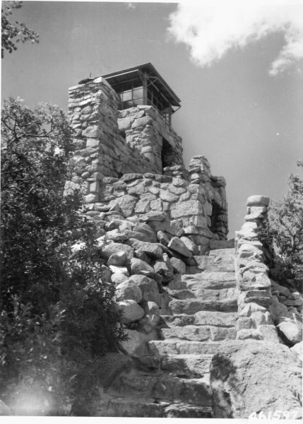
33°38′35″N 105°52′42″W / 33.643056°N 105.878333°WCarrizozo Now Roy's Ice Cream Parlour 28 Ruidoso Lookout Tower January 27, 1988 Lincoln National Forest
33°19′54″N 105°39′43″W / 33.331667°N 105.661944°WRuidoso 29 White Oaks Historic District 
September 4, 1970 12 miles northeast of Carrizozo on State Road 349
33°45′03″N 105°45′22″W / 33.750833°N 105.756111°WWhite Oaks 30 Wizard's Roost August 2, 1982 Address Restricted Capitan See also
- List of National Historic Landmarks in New Mexico
- National Register of Historic Places listings in New Mexico
References
- ^ The latitude and longitude information provided in this table was derived originally from the National Register Information System, which has been found to be fairly accurate for about 99% of listings. For about 1% of NRIS original coordinates, experience has shown that one or both coordinates are typos or otherwise extremely far off; some corrections may have been made. A more subtle problem causes many locations to be off by up to 150 yards, depending on location in the country: most NRIS coordinates were derived from tracing out latitude and longitudes off of USGS topographical quadrant maps created under North American Datum of 1927, which differs from the current, highly accurate GPS system used by Google maps. Chicago is about right, but NRIS longitudes in Washington are higher by about 4.5 seconds, and are lower by about 2.0 seconds in Maine. Latitudes differ by about 1.0 second in Florida. Some locations in this table may have been corrected to current GPS standards.
- ^ "National Register of Historic Places: Weekly List Actions". National Park Service, United States Department of the Interior. Retrieved on November 10, 2011.
- ^ Numbers represent an ordering by significant words. Various colorings, defined here, differentiate National Historic Landmark sites and National Register of Historic Places Districts from other NRHP buildings, structures, sites or objects.
- ^ "National Register Information System". National Register of Historic Places. National Park Service. . http://nrhp.focus.nps.gov/natreg/docs/All_Data.html.
U.S. National Register of Historic Places Topics Lists by states Alabama • Alaska • Arizona • Arkansas • California • Colorado • Connecticut • Delaware • Florida • Georgia • Hawaii • Idaho • Illinois • Indiana • Iowa • Kansas • Kentucky • Louisiana • Maine • Maryland • Massachusetts • Michigan • Minnesota • Mississippi • Missouri • Montana • Nebraska • Nevada • New Hampshire • New Jersey • New Mexico • New York • North Carolina • North Dakota • Ohio • Oklahoma • Oregon • Pennsylvania • Rhode Island • South Carolina • South Dakota • Tennessee • Texas • Utah • Vermont • Virginia • Washington • West Virginia • Wisconsin • WyomingLists by territories Lists by associated states Other  Category:National Register of Historic Places •
  Portal:National Register of Historic Places
Municipalities and communities of Lincoln County, New Mexico County seat: Carrizozo City 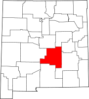
Town Villages Unincorporated
communitiesAlto | Lincoln | Hondo | San Patricio
Ghost town Categories:- National Register of Historic Places in New Mexico by county
- Lincoln County, New Mexico
- History of Lincoln County, New Mexico
-


Wikimedia Foundation. 2010.