- Carrizozo, New Mexico
Infobox Settlement
official_name = Carrizozo, New Mexico
settlement_type =Town
nickname =
motto =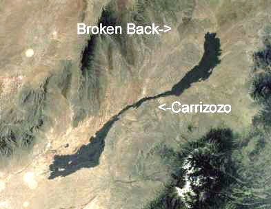
imagesize = 250px
image_caption = Official scenic historic marker at eastern town limit
image_
image_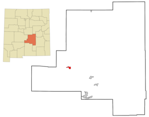
mapsize = 250px
map_caption = Location of Carrizozo, New Mexico
mapsize1 =
map_caption1 =subdivision_type = Country
subdivision_name =United States
subdivision_type1 = State
subdivision_name1 =New Mexico
subdivision_type2 = County
subdivision_name2 = Lincoln
government_footnotes =
government_type =
leader_title =
leader_name =
leader_title1 =
leader_name1 =
established_title =
established_date =unit_pref = Imperial
area_footnotes =area_magnitude =
area_total_km2 = 7.0
area_land_km2 = 7.0
area_water_km2 = 0.0
area_total_sq_mi = 2.7
area_land_sq_mi = 2.7
area_water_sq_mi = 0.0population_as_of = 2000
population_footnotes =
population_total = 1036
population_density_km2 = 147.5
population_density_sq_mi = 382.1timezone = Mountain (MST)
utc_offset = -7
timezone_DST = MDT
utc_offset_DST = -6
elevation_footnotes =
elevation_m = 1657
elevation_ft = 5436
latd = 33 |latm = 38 |lats = 38 |latNS = N
longd = 105 |longm = 52 |longs = 39 |longEW = Wpostal_code_type =
ZIP code
postal_code = 88301
area_code = 575
blank_name = FIPS code
blank_info = 35-12500
blank1_name = GNIS feature ID
blank1_info = 0918425
website =
footnotes = Carrizozo is a town in Lincoln County,New Mexico , in theUnited States . As of the 2000 census, the town population was 1,036. It is the seat of Lincoln CountyGR|6 and is in theTularosa Basin .Geography
Carrizozo is located at coor dms|33|38|38|N|105|52|39|W|city (33.643946, -105.877435)GR|1.
According to the
United States Census Bureau , the town has a total area of 2.7square mile s (7.0km² ), all of it land.See
Carrizozo Malpais for information on volcanic activity in this area.Demographics
As of the
census GR|2 of 2000, there were 1,036 people, 435 households, and 264 families residing in the town. Thepopulation density was 382.1 people per square mile (147.6/km²). There were 514 housing units at an average density of 189.6/sq mi (73.2/km²). The racial makeup of the town was 74.81% White, 0.68% African American, 1.83% Native American, 0.10% Pacific Islander, 19.21% from other races, and 3.38% from two or more races. Hispanic or Latino of any race were 53.47% of the population.There were 435 households out of which 23.0% had children under the age of 18 living with them, 45.3% were married couples living together, 12.4% had a female householder with no husband present, and 39.1% were non-families. 35.6% of all households were made up of individuals and 18.9% had someone living alone who was 65 years of age or older. The average household size was 2.18 and the average family size was 2.79.
In the town the population was spread out with 20.9% under the age of 18, 5.3% from 18 to 24, 24.8% from 25 to 44, 27.5% from 45 to 64, and 21.4% who were 65 years of age or older. The median age was 44 years. For every 100 females there were 107.6 males. For every 100 females age 18 and over, there were 103.7 males.
The median income for a household in the town was $22,647, and the median income for a family was $29,625. Males had a median income of $24,583 versus $17,708 for females. The
per capita income for the town was $12,243. About 21.0% of families and 26.8% of the population were below thepoverty line , including 40.4% of those under age 18 and 25.0% of those age 65 or over.Points of Interest
*
Lincoln National Forest (southeast of the city viaU.S. Route 380 and NM 37)
*Valley of Fires Recreation Area (west-northwest of the city viaU.S. Route 380 )Transportation
Airports
*
Carrizozo Municipal Airport Major Highways
Carrizozo is located at the intersection of two U.S. highways:
*U.S. Route 54
*U.S. Route 380 References
External links
* [http://www.townofcarrizozo.org/ Town of Carrizozo]
* [http://www.villageofcapitan.com/corridor.html Capitan-Carrizozo Corridor map - Historic New Mexico Highway 380]
Wikimedia Foundation. 2010.