- June 2010 Northern Plains tornado outbreak
-
Mid-June 2010 tornado outbreak Tracks of the 74 tornadoes that touched down across the Northern Plains on June 17
Date of tornado outbreak: June 16 – 18, 2010 Duration1: 56 hours, 52 minutes Maximum rated tornado2: EF4 tornado Tornadoes caused: 93 confirmed Damages: $117.7 million Fatalities: 3 + 2 non-tornadic Areas affected: Midwest and Northern Plains of the United States 1Time from first tornado to last tornado
2Most severe tornado damage; see Enhanced Fujita ScaleThe June 2010 Northern Plains tornado outbreak was one of the most prolific summer tornado outbreaks in the Northern Great Plains of the United States on record. The outbreak began on June 16 with a several tornadoes in South Dakota and Montana. The most intense storms took place the following day across much of eastern North Dakota and much of Minnesota and North Dakota. The system produced 93 tornadoes reported across four states while killing three people in Minnesota. Four of the tornadoes were rated as EF4 on the Enhanced Fujita scale, the most violent tornadoes in a 24-hour period since there were five within 15 hours on February 5-6, 2008. This was the region's first major tornado outbreak of the year and one of the largest on record in the region, comparable to a similar outbreak in June 1992. The 48 tornadoes that touched down in Minnesota on June 17 marked the most active single day in the state's history.[1] June 17 was the second largest tornado day on record in the meteorological summer, behind the most prolific day of the 2003 South Dakota tornado outbreak on June 24, 2003.
Contents
Synopsis
On June 16, 2010, an upper-level area of low pressure and associated trough moved southeastward across the Rocky Mountains into the Great Plains. Along the base of the trough, the presence of a strong mid-level jet stream provided significant instability; however, warm-air aloft was expected to limit the extent of convective development. Moderate to strong deep layer wind shear along with steep lapse rates would allow for the development of supercell thunderstorms with large hail (greater than 2 in (5.1 cm) in diameter). In light of this, the Storm Prediction Center issued a slight-risk of severe weather for portions of Colorado, Montana, Nebraska, North Dakota, South Dakota and Wyoming.[2]
The Storm Prediction Center issued a moderate risk of severe weather for June 17, 2010 citing a 10% threat for tornadoes, 45% threat for large hail and 45% threat for damaging wind, initially thinking tornadoes would quickly reform into a straight-line wind event. The moderate risk area extended from around Fargo, North Dakota to Des Moines, Iowa and Omaha, Nebraska including the Twin Cities area, with a slight risk area extending across the Upper Midwest. Surface dew points reached the low 70's°F (low 20's°C) with surface temperatures well into 80s°F (near 30°C) across Minnesota. Surface-based CAPE values were forecast to reach 2000–3000 j/kg.[3]
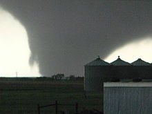
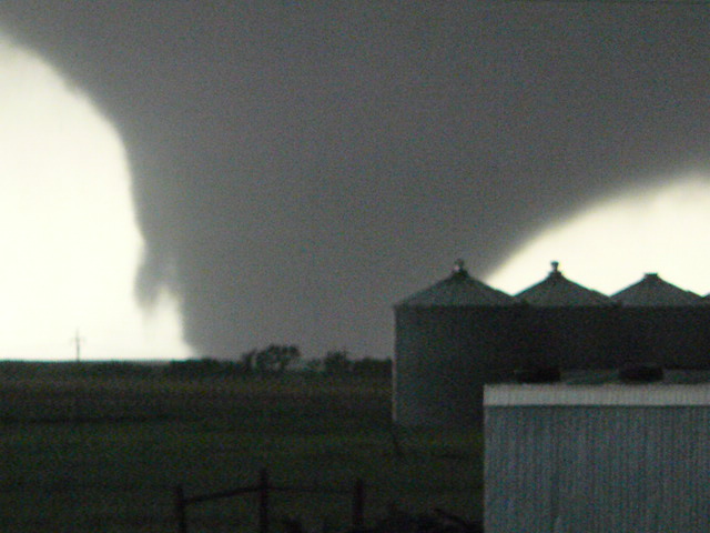
The first tornadoes were reported across eastern North Dakota during the mid-afternoon hours where a tornado watch was issued for most of the state as well as extreme northwestern Minnesota closer to the Manitoba and northwestern Ontario borders where many tornadoes, some strong to violent, touched down late that afternoon.[4] After several tornadoes affected areas near the Grand Forks area and closer to the Canadian border, the activity eventually shifted into northwestern Minnesota by the late afternoon hours while storms over northern Iowa moved across southern Minnesota near the Interstate 90 corridor producing many tornadoes. Other storms developed over central Minnesota near Interstate 94 but most activity missed the Twin Cities area. The supercells eventually reached the Wisconsin border later that evening and reformed into a squall line, rapidly ending the severe weather outbreak. Isolated tornado reports also occurred across Wisconsin and Iowa. Three people were killed according to KARE-TV including one in Mentor (Polk County), one in Almora (Otter Tail County)[5] and one near Albert Lea (Freeborn County) an area that sustained heavy damage from a possible long-track tornado.[6] Large tornadoes were sighted in Kiester in Faribault County and near Ellendale and Blooming Prairie in Steele County, Minnesota.[7]
The town of Wadena was also hard hit; the high school was heavily damaged by a tornado that prompted a tornado emergency. Extensive damage was also reported in various other communities in Minnesota as well as in North Dakota from either tornadoes or widespread damaging winds such as in the Rochester, Minnesota area where several buildings, including homes, were heavily damaged on the northern side of the town. A local emergency was declared in Rochester by the mayor following the storms.[8] The three tornado fatalities in Minnesota were the most for a single outbreak since 1978, and the three EF4 tornadoes were the most on a single day since 1967.[9]
A moderate risk of severe weather was issued for parts of southern Iowa, northern Missouri and northwestern Illinois during the mid-morning of June 18 citing mostly the threat for damaging winds (45%), though a few tornadoes would be possible as CAPE values of 4000 j/kg were forecast across the Missouri and mid-Mississippi Valleys, especially behind the main derecho.[10] Such did not materialize, however.
Tornadoes reported
Confirmed
TotalConfirmed
EF0Confirmed
EF1Confirmed
EF2Confirmed
EF3Confirmed
EF4Confirmed
EF593 48 28 9 4 4 0 June 16 event
List of reported tornadoes - Wednesday, June 16, 2010 EF# Location County Coord. Time (UTC) Path length Comments/Damage South Dakota EF0 S of Red Elm (1st tornado) Ziebach 44°57′N 101°46′W / 44.95°N 101.767°W 2304 – 2305 unknown Brief tornado touchdown with no damage.[11] EF0 S of Red Elm (2nd tornado) Ziebach 45°00′N 101°46′W / 45°N 101.767°W 2330 – 2332 unknown Brief tornado touchdown with no damage.[12] EF0 S of Red Elm (3rd tornado) Ziebach 45°00′N 101°46′W / 45°N 101.767°W 2340 unknown Brief tornado touchdown with no damage.[12] EF0 S of Red Elm (4th tornado) Ziebach 45°00′N 101°46′W / 45°N 101.767°W 2341 unknown Brief tornado touchdown with no damage.[12] EF1 SW of Dupree (1st tornado) Ziebach 45°01′N 101°40′W / 45.017°N 101.667°W 0022 – 0045 2 miles (3.2 km) A brief tornado downed several power lines.[13] EF0 SW of Dupree (2nd tornado) Ziebach 0030 unknown Satellite tornado to the previous event.[13] EF2 Dupree area Ziebach 45°02′N 101°36′W / 45.033°N 101.6°W 0033 – 0049 1 mile (1.6 km) Significant damage in the community with several houses heavily damaged, the local community center lost its roof and mobile homes and grain bins were destroyed. Two people were injured and damage amounted to $750,000.[14] EF0 WNW of Dupree (1st tornado) Ziebach 45°03′N 101°36′W / 45.05°N 101.6°W 0040 – 0042 unknown Brief tornado touchdown with no damage.[15] EF0 WNW of Dupree (2nd tornado) Ziebach 45°03′N 101°36′W / 45.05°N 101.6°W 0040 unknown Brief tornado touchdown with no damage.[15] EF0 NW of Dupree (1st tornado) Ziebach 45°05′N 101°38′W / 45.08°N 101.63°W 0053 – 0058 unknown Brief tornado touchdown with no damage.[16] EF0 NW of Dupree (2nd tornado) Ziebach 45°05′N 101°38′W / 45.08°N 101.63°W 0053 unknown Brief tornado touchdown with no damage.[16] EF0 NW of Dupree (3rd tornado) Ziebach 45°05′N 101°38′W / 45.08°N 101.63°W 0053 unknown Brief tornado touchdown with no damage.[16] EF0 NW of Dupree (4th tornado) Ziebach 45°05′N 101°38′W / 45.08°N 101.63°W 0054 unknown Brief tornado touchdown with no damage.[16] EF0 NW of Dupree (5th tornado) Ziebach 45°05′N 101°38′W / 45.08°N 101.63°W 0056 unknown Brief tornado touchdown with no damage.[16] EF0 NW of Dupree (6th tornado) Ziebach 45°05′N 101°38′W / 45.08°N 101.63°W 0058 unknown Brief tornado touchdown with no damage.[16] EF0 NW of Dupree (7th tornado) Ziebach 45°05′N 101°38′W / 45.08°N 101.63°W 0058 unknown Brief tornado touchdown with no damage.[16] EF2 ENE of Lantry Dewey 45°03′N 101°19′W / 45.05°N 101.32°W 0135 – 0138 unknown Brief but intense tornado resulted in severe structural damage to two houses and several pole barns were destroyed, killing a horse.[17] Montana EF1 E of Fort Peck McCone 47°59′N 106°04′W / 47.99°N 106.07°W 0256 – 0304 3 miles (4.8 km) Storage sheds were damaged and numerous trees were snapped.[18] Sources: SPC Storm Reports for 06/16/10, NWS Rapid City, NCDC Storm Data
June 17 event
List of reported tornadoes - Thursday, June 17, 2010 EF# Location County Coord. Time (UTC) Path length Comments/Damage North Dakota EF1 SW of Hettinger Adams 45°59′N 102°38′W / 45.99°N 102.63°W 1435 – 1440 0.6 miles (0.97 km) A brief tornado touched down along the southwest side of Hettinger, breaking windows in an apartment building and slightly lifting a car off the ground. Damage from the tornado reached $25,000.[19] One of two non-supercell tornadoes spawned during the outbreak.[20] EF0 E of Noonan Burke 48°53′N 102°55′W / 48.89°N 102.92°W 1931 – 1940 3.5 miles (5.6 km) Brief tornado touchdown near the Canadian border with known damage.[21] Second of two non-supercell tornadoes.[20] EF0 NW of Gackle Stutsman 46°49′N 99°14′W / 46.81°N 99.24°W 1955 3 miles (4.8 km) Tornado remained over open country. EF0 NE of Finley Steele 47°34′N 97°47′W / 47.57°N 97.79°W 2038 4 miles (6.4 km) Tornado spotted by off-duty NWS Dodge City meteorologist with no damage. EF0 NE of Pingree Stutsman 47°11′N 98°53′W / 47.18°N 98.88°W 2044 unknown Brief tornado touchdown with no damage. EF4 Thompson area Traill, Grand Forks 47°47′N 97°10′W / 47.78°N 97.17°W 2049 17 miles (27 km) A well-built house was blown away with only a concrete slab remaining and a welding building and several farm buildings were destroyed. One person sustained minor injuries. EF1 N of Berea Barnes 47°01′N 98°06′W / 47.01°N 98.10°W 2101 1 mile (1.6 km) Several trees and a wooden power pole were knocked down. EF0 WSW of Dazey Barnes 47°10′N 98°13′W / 47.16°N 98.22°W 2105 unknown Brief tornado touchdown with no damage. EF0 E of Sheyenne Eddy, Benson 47°49′N 98°52′W / 47.82°N 98.87°W 2127 1 mile (1.6 km) Tornado remained over open country. EF2 Hope area (1st tornado) Steele 47°19′N 97°46′W / 47.31°N 97.77°W 2128 7 miles (11 km) Severe tree damage reported at a golf course and on a farm. EF1 Hope area (2nd tornado) Steele 47°15′N 97°40′W / 47.25°N 97.67°W 2130 7 miles (11 km) An irrigation system was damaged and trees were knocked down. EF2 S of Ojata Grand Forks 47°56′N 97°19′W / 47.94°N 97.31°W 2131 7 miles (11 km) Debris was thrown in the area, including near Grand Forks Air Force Base. Many trees were snapped and a pole barn was destroyed. EF2 ENE of Hope Steele 47°21′N 97°37′W / 47.35°N 97.61°W 2140 3 miles (4.8 km) An abandoned farmhouse was destroyed and several farm buildings were heavily damaged. Trees were also damaged. EF1 NW of Grand Forks Grand Forks 47°58′N 97°11′W / 47.96°N 97.19°W 2147 10 miles (16 km) A pole barn was damaged and trees were snapped or uprooted. EF0 NNE of Sherbrooke Steele 47°37′N 97°34′W / 47.62°N 97.56°W 2202 3 miles (4.8 km) Minor damage limited to a few trees. EF0 N of Dahlen Nelson 48°09′N 97°58′W / 48.15°N 97.96°W 2215 3 miles (4.8 km) A few tree limbs were knocked down. EF1 NE of Poland Walsh, Marshall (MN) 48°16′N 97°08′W / 48.26°N 97.14°W 2221 5 miles (8.0 km) Several large trees were snapped along the Red River. EF0 SE of Orr Grand Forks 48°04′N 97°38′W / 48.07°N 97.64°W 2222 1 mile (1.6 km) A few tree limbs were knocked down. EF0 W of Thompson Grand Forks 47°46′N 97°08′W / 47.76°N 97.14°W 2230 8 miles (13 km) Intermittent tornado touchdown with minor tree damage. EF0 E of Gilby Grand Forks 48°05′N 97°29′W / 48.09°N 97.48°W 2237 2 miles (3.2 km) Tornado remained over open country. EF1 W of Fordville Walsh 48°13′N 97°51′W / 48.21°N 97.85°W 2241 2 miles (3.2 km) Several trees were snapped or uprooted. EF1 S of Orr Grand Forks 48°05′N 97°40′W / 48.09°N 97.66°W 2245 4 miles (6.4 km) Several trees were snapped or uprooted. Minnesota EF0 SW of Fossum Norman 47°13′N 96°11′W / 47.22°N 96.19°W 2028 1 mile (1.6 km) Minor tree damage in a cemetery. EF4 S of Deer Creek Douglas, Otter Tail 46°05′N 95°28′W / 46.09°N 95.46°W 2043 40 miles (64 km) 1 death - Large multiple-vortex tornado flattened several houses and blew them away along Otter Tail County Road 143, one of which had an occupant killed. Numerous other houses were damaged or destroyed. Farm buildings were also obliterated by the tornado, which was up to 1.3 miles (2.1 km) wide. Trees were also debarked and vehicles were thrown into the air. Five others were injured. EF0 E of Vergas Otter Tail 46°40′N 95°45′W / 46.67°N 95.75°W 2055 unknown Brief tornado touchdown with no damage. EF0 E of Bejou Mahnomen, Polk 47°26′N 95°53′W / 47.43°N 95.89°W 2100 6 miles (9.7 km) A few trees were knocked down. EF1 W of Lake Itasca Clearwater 47°10′N 95°22′W / 47.17°N 95.37°W 2132 1 mile (1.6 km) Trees and limbs were snapped along Long Lost Lake. EF1 NW of Zerkel Clearwater 47°20′N 95°29′W / 47.34°N 95.48°W 2141 3 miles (4.8 km) One house sustained minor damage. Extensive tree damage along the path. EF1 S of Bluffton Otter Tail 46°18′N 95°13′W / 46.3°N 95.217°W 2148 – 2150 1.5 miles (2.4 km) See section on this tornado EF4 Wadena area Otter Tail, Wadena 46°24′N 95°10′W / 46.4°N 95.167°W 2159 – 2216 10 miles (16 km) See section on this tornado EF0 NW of Elmore Faribault 43°32′N 94°08′W / 43.54°N 94.13°W 2205 3 miles (4.8 km) A metal shed was damaged and trees were uprooted. EF1 SE of Goodridge Pennington 48°07′N 95°46′W / 48.11°N 95.77°W 2207 2 miles (3.2 km) Heavy farm equipment was moved around and a few trees were damaged. EF1 W of Lake George Hubbard 47°10′N 95°08′W / 47.16°N 95.14°W 2217 6 miles (9.7 km) Many large trees were snapped or uprooted. EF0 NW of Winsted McLeod 44°58′N 94°03′W / 44.97°N 94.05°W 2223 0.75 miles (1.21 km) Isolated tree and limb damage and minor crop damage. EF1 SW of Clearbrook Clearwater 47°38′N 95°25′W / 47.64°N 95.42°W 2229 1 mile (1.6 km) Several trees and power poles were damaged. EF0 SSW of Nimrod to SSW of Osnawa Wadena, Cass 46°36′N 94°52′W / 46.6°N 94.867°W 2230 – 2248 14.8 miles (23.8 km) See section on this tornado EF0 SE of Eagle Lake Blue Earth 44°09′N 93°52′W / 44.15°N 93.87°W 2237 3 miles (4.8 km) Two sheds sustained minor damage. Many trees were damaged. EF0 NE of Elmore Faribault 43°31′N 94°01′W / 43.52°N 94.01°W 2240 1.9 miles (3.1 km) Damage mostly to trees from this second tornado in the area. EF1 NE of Gatzke Marshall, Roseau 48°28′N 95°37′W / 48.46°N 95.62°W 2244 4 miles (6.4 km) Numerous trees were snapped or uprooted. EF0 W of Kabekona Corner Hubbard 47°13′N 94°55′W / 47.21°N 94.91°W 2248 4 miles (6.4 km) Damage limited to tree branches. EF0 W of Benedict Hubbard 47°07′N 94°47′W / 47.12°N 94.79°W 2249 1 mile (1.6 km) Damage limited to tree branches. EF1 Fisher area Polk 47°52′N 96°50′W / 47.86°N 96.84°W 2250 7 miles (11 km) Well-defined tornado sighted by an off-duty SPC meteorologist. A shed was destroyed and many trees were damaged. EF0 NE of Clear Lake (1st tornado) Sherburne 45°29′N 93°57′W / 45.49°N 93.95°W 2254 unknown Brief tornado touchdown with no damage. EF0 NE of Clear Lake (2nd tornado) Sherburne 45°29′N 93°58′W / 45.48°N 93.96°W 2256 3 miles (4.8 km) Numerous trees were snapped by a second tornado that touched down as the first one dissipated. EF1 N of Buffalo Wright 45°11′N 93°52′W / 45.18°N 93.87°W 2300 5 miles (8.0 km) Many trees were damaged, including snapped trunks, around Constance Lake. EF1 W of Gentilly Polk 47°47′N 96°28′W / 47.79°N 96.46°W 2300 3 miles (4.8 km) A grain bin was tossed and trees were uprooted. EF0 SSW of Bricelyn Faribault 43°31′N 93°51′W / 43.51°N 93.85°W 2305 1 mile (1.6 km) Tornado remained over open country. EF0 N of Angus Polk 48°05′N 96°43′W / 48.09°N 96.71°W 2306 2 miles (3.2 km) One house sustained minor damage and a few tree limbs were knocked down. EF0 SW of Walters Faribault 43°31′N 93°50′W / 43.51°N 93.83°W 2310 unknown Spotter reported tornado on the ground. No damage reported. EF2 Kiester area (1st tornado) Faribault 43°30′N 93°43′W / 43.50°N 93.71°W 2313 1 mile (1.6 km) Several grain bins were destroyed and many trees were knocked down. EF3 Mentor area Polk, Red Lake 47°40′N 96°08′W / 47.67°N 96.13°W 2315 15 miles (24 km) 1 death - A Cenex station was hit killing one person. The gas station and four vehicles were destroyed by the multiple-vortex tornado. Many trees, farm buildings and a farm house were also heavily damaged and cabins and cottages were heavily damaged along Maple Lake. EF2 Kiester area (2nd tornado) Faribault 43°31′N 93°43′W / 43.52°N 93.71°W 2316 unknown Tornado quickly developed after the first Keister tornado developed, the two tornadoes merged. Severe tree damage in the area. EF1 E of Dorothy Red Lake 47°55′N 96°22′W / 47.92°N 96.36°W 2316 2 miles (3.2 km) A parked semi-trailer was blown off a highway, injuring the driver. EF0 E of Kiester Faribault 43°32′N 93°39′W / 43.54°N 93.65°W 2323 unknown Brief tornado touchdown with no damage. EF1 N of Radium Marshall 48°16′N 96°37′W / 48.27°N 96.62°W 2326 7 miles (11 km) Large trees were snapped and a shed was damaged. EF1 SE of Walters Faribault, Freeborn 43°34′N 93°38′W / 43.57°N 93.64°W 2328 unknown Brief tornado damaged a few trees. EF4 W of Albert Lea Freeborn 43°37′N 93°32′W / 43.62°N 93.53°W 2333 20 miles (32 km) 1 death - Dozens of farms were affected and several houses were destroyed or flattened by this large wedge tornado. Three hog confinements were destroyed with several hogs escaping. A wind energy facility was also damaged. There were also additional major infrastructure damage along with gas leaks. Trees were also debarked. 14 others were injured, some severely. EF1 Armstrong Freeborn 43°41′N 93°29′W / 43.69°N 93.48°W 2355 1 mile (1.6 km) Satellite tornado related to the Albert Lea tornado. Several grain bins, structures and trees were damaged. EF3 Ellendale area Freeborn, Steele 43°50′N 93°18′W / 43.84°N 93.30°W 0005 18.7 miles (30.1 km) One house and many outbuildings were destroyed and several other houses were damaged. Many trees were damaged, some of which were debarked. EF1 Clarks Grove area Freeborn, Steele 43°36′N 93°22′W / 43.60°N 93.37°W 0015 12.9 miles (20.8 km) Tornado paralleled the Ellendale tornado. Damage to farm houses, many outbuildings (some of which were destroyed) and trees. EF1 SW of Lerdal Freeborn 43°43′N 93°16′W / 43.71°N 93.27°W 0042 5 miles (8.0 km) A barn was destroyed and sheds were damaged. EF3 W of Hollandale Freeborn 43°46′N 93°16′W / 43.76°N 93.27°W 0047 5 miles (8.0 km) One house and many outbuildings were flattened and several other houses were damaged, some severely. Major damage to trees with some debarked. EF1 WSW of Newry Freeborn 43°49′N 93°08′W / 43.81°N 93.14°W 0103 2 miles (3.2 km) Three farm houses were damaged, and numerous sheds and outbuildings were also damaged. EF0 S of Hill City Aitkin 46°55′N 93°37′W / 46.91°N 93.61°W 0105 1 mile (1.6 km) Brief tornado captured by a mobile phone photograph in the Moose Willow State Wildlife Management Area with minimal damage. EF3 W of Blooming Prairie Steele 43°52′N 93°07′W / 43.87°N 93.11°W 0110 8 miles (13 km) One house was flattened and numerous others were damaged. Trees were also debarked. Debris also flew into a mobile home where one person was injured. EF2 N of Blooming Prairie (1st tornado) Steele, Dodge 43°53′N 93°04′W / 43.88°N 93.07°W 0121 6 miles (9.7 km) A manufactured home was destroyed, injuring a resident. Sheds, outbuildings and grain bins were also destroyed. It crossed paths with the 0110 UTC tornado. EF0 N of Blooming Prairie (2nd tornado) Steele, Dodge 43°58′N 93°00′W / 43.97°N 93.00°W 0122 6 miles (9.7 km) A shed was destroyed and numerous trees were damaged. EF2 NE of Rush City Chisago, Pine, Burnett (WI) 45°47′N 92°47′W / 45.78°N 92.79°W 0144 8 miles (13 km) A mobile home was destroyed and several houses were damaged. Extensive tree damage along the path. Two people were injured. EF1 Rochester Olmsted 44°01′N 92°29′W / 44.01°N 92.48°W 0203 1.5 miles (2.4 km) Major damage in the north side of town with 75 homes damaged and ten severely damaged or destroyed. Other buildings including a Menards store and other businesses around it were damaged. Several trees were blown down. Iowa EF0 NE of Lakota Kossuth 43°22′N 94°09′W / 43.37°N 94.15°W 2216 1 mile (1.6 km) Tornado remained over open country. EF0 NE of Ledyard Kossuth 43°27′N 94°01′W / 43.45°N 94.02°W 2224 1 mile (1.6 km) Tornado spotted along Highway 169. No damage was reported. EF0 E of Rake Winnebago 43°29′N 93°52′W / 43.48°N 93.86°W 2305 2 miles (3.2 km) Tornado spotted by fire department with no damage. Wisconsin EF0 N of Grantsburg Burnett 45°47′N 92°39′W / 45.79°N 92.65°W 0205 unknown A few trees were snapped. EF1 W of Cream Buffalo 44°19′N 91°47′W / 44.32°N 91.78°W 0257 2 miles (3.2 km) A few buildings were damaged and many trees were sheared or uprooted. Sources: SPC Storm Reports for 06/17/10, NWS Twin Cities, NWS Twin Cities - Final list, NWS Duluth, NWS Grand Forks, NWS La Crosse, NCDC Storm Data
June 18 event
List of reported tornadoes - Friday, June 18, 2010 EF# Location County Coord. Time (UTC) Path length Comments/Damage Iowa EF0 NNE of St. Charles Madison 41°19′N 93°48′W / 41.317°N 93.8°W 2155 – 2156 1 mile (1.6 km) Brief tornado touchdown over an open field.[22] Sources: Wadena supercell
Around 3:20 p.m. CDT (2120 UTC), a supercell thunderstorm developed over Stevens County, Minnesota and initially tracked north-northeastward before turning fully northeast. Once over Otter Tail County, the storm intensified and a brief EF1 tornado touched down around 4:48 pm CDT (2248 UTC) roughly 12 mi (19 km) south of Bluffton.[20] The rear-flank downdraft of the storm quickly obscured the tornado from view; however, it was later determined the tornado was on the ground for 1.5 mi (2.4 km), uprooting small trees and snapping limbs of lager ones.[23] At 4:56 pm CDT (2256 UTC), a tornado warning was issued for portions of Becker, Clearwater, Hubbard, Otter Tail and Wadena Counties.[24] Only two minutes after the warning was issued, a new tornado touched down about 3 mi (4.8 km) southwest of the city of Wadena.[20] Within three minutes of forming, the multiple vortex tornado rapidly intensified, reaching EF4 intensity with winds estimated at 170 mph (270 km/h). Before crossing the Otter Tail-Wadena County border, the storm's width had reached 1.1 mi (1.8 km).[25] The tornado then struck the western side of Wadena, causing widespread damage.[26] In light of the damage in the city, a tornado emergency was declared for Sebeka and Nimrod; however, substantial damage never took place in these areas.[24] Continuing northeastward, the tornado gradually weakened before dissipating at 5:16 pm CDT (2316 UTC), ending its 10 mi (16 km) track.[26] Around 5:30 pm CDT (2230 UTC), a third tornado, rated EF0, touched down within the supercell, this time roughly 1.5 mi (2.4 km) south-southwest of Nimrod. Over the following 18 minutes, this storm made several touchdowns along a 14.8 mi (23.8 km) track that continued into Cass County.[20] Damage from this tornado was largely limited to broken tree limbs.[27] Continuing northeast, the supercell eventually dissipated over Cass County around 6:30 pm CDT (2330 UTC).[20]
Two houses were blown away from their foundations and many other houses and businesses were destroyed by this large wedge tornado. Wadena High School lost its roof. A bus garage and an apartment complex were also damaged and school buses were thrown into the air. Trees were also debarked. About 20 people were injured. Damage from the tornado reached $32 million, making it the most destructive of the outbreak.[28]
Canadian Prairies flooding
North of the tornadic supercells, heavy rain affected areas of the southern Canadian Prairies where at least 4 to 6 in (100 to 150 mm) of rain fell across southern Alberta and Saskatchewan on June 16 – 17 causing widespread flooding. A state of emergency was declared at the Blood Tribe Indian Reserve where people were stranded in homes due to flood waters.[29] Nine municipal governments in Alberta also declared state of emergencies due to the flooding as did some areas of southern Saskatchewan. Portions of the Trans-Canada Highway were closed for 3 km (1.9 mi) due to flooding along the border between Saskatchewan and Alberta on June 18 and remained shut down until June 26.[30] At times, 30,000 to 40,000 acres (12,000 to 16,000 ha) of land around the highway was submerged by flood waters.[31] Other roads and bridges were flooded and in some cases washed away. The Cypress Hills Interprovincial Park was also left inaccessible.[30] In and around Medicine Hat, Alberta, most residents were forced to evacuate as water reached depths of 2 ft (0.61 m). Agricultural areas sustained considerable losses throughout the region as entire harvests were lost to the floods and much of the growing season had past leaving no time to re-plant crops.[32] Throughout Alberta, losses reached C$69 million ($70.3 million), including C$54 million ($55 million) in Medicine Hat alone. A total of 340 homes were affected by the floods, 11 of which had to be condemned. Additionally, 490 ft (150 m) of the Trans-Canada Highway had been washed out.[31][33]
Due to the prolonged shut down of the Trans-Canada Highway, many businesses along the road experienced hundreds of thousands of dollars in lost profits. Some stores reported a 95 percent decrease in income, roughly C$4,000 daily.[31] On June 25, some residents in Medicine Hat were given C$3,000 in aid from the Provincial Disaster Assistance Program. In the weeks after the disaster, reconstruction of roadways and bridges washed out by the floods began. Engineers estimated that it would take four to five weeks to repair the Trans-Canada Highway.[33]
June 18 Midwest derechos
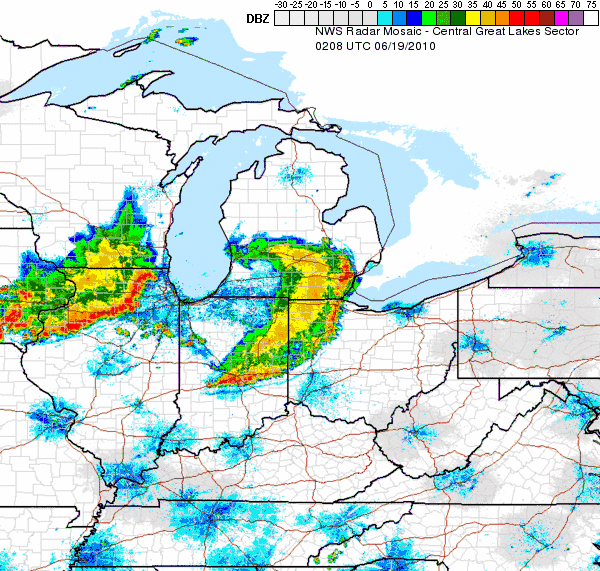
 A NWS enhanced radar image of the two derechos in the Midwest on the night of June 18th, 2010.
Following the prolific tornado outbreak, a mesoscale convective system developed across eastern Nebraska in the Omaha area during the morning hours of June 18. It gradually intensified before moving into the Des Moines area near midday.[34] The bow echo intensified into an intense progressive derecho over eastern Iowa and propagated eastward into northern Illinois and southern Wisconsin that afternoon. Extensive damage was reported from the derecho, including in the Chicago metropolitan area as the derecho reached that region shortly before 4:00 pm CDT (2100 UTC).[35] Nearly 300,000 customers lost power and windows were blown out of high-rise buildings in downtown Chicago.[36] Some counties utilized warning sirens due to the derecho's extreme winds, despite the fact there was no tornado.[37]
The derecho continued eastward, maintaining its strength over southern Lower Michigan and northern Indiana in the early evening hours. Winds as high as 90 mph (150 km/h) were reported in southwest Michigan with widespread damage over the region).[35] The storm knocked out power to nearly 300,000 customers of Commonwealth Edison in the Chicago area. Windows were blown out of several high rises in downtown Chicago, including the tallest building, the Willis Tower. [38] More than 100,000 lost power in the immediate Detroit region including in Oakland and Wayne Counties [39], over 75,000 in the Grand Rapids/Kalamazoo regions [40] and over 50,000 in northern Indiana and southwestern Michigan. [41] The derecho finally weakened and rapidly dissipated as it reached Lake Erie.
During the evening hours of June 18, a second, weaker derecho formed over Iowa and began following a path similar to the first one, and by 8:45 pm CDT (0145 UTC) the storm was moving across Illinois causing damage in areas already affected by the initial derecho event before weakening and dissipating.[35] One fatality was reported from the event in northern Indiana and in Dexter, Michigan.[35] This storm also produced dangerous lightning with two homes hit by lightning in Dexter and Scio Twp in Michigan.
See also
- Tornadoes of 2010
References
- ^ http://www.crh.noaa.gov/images/mpx/2010torlist.pdf
- ^ John Chris Broyles and Jonathan M. Garner (June 16, 2010). "Jun 16, 2010 0600 UTC Day 1 Convective Outlook". Storm Prediction Center. National Oceanic and Atmospheric Administration. http://www.spc.noaa.gov/products/outlook/archive/2010/day1otlk_20100616_1200.html. Retrieved June 19, 2011.
- ^ http://www.spc.noaa.gov/products/outlook/archive/2010/day1otlk_20100617_1200.html
- ^ http://www.spc.noaa.gov/products/watch/ww0333.html
- ^ http://www.kare11.com/news/news_article.aspx?storyid=853123&hpt=T2
- ^ http://www.kare11.com/news/news_article.aspx?storyid=853968
- ^ http://www.kttc.com/Global/story.asp?S=12669739
- ^ http://www.kttc.com/Global/story.asp?S=12669739
- ^ http://www.crh.noaa.gov/mpx/?n=10june17
- ^ http://www.spc.noaa.gov/products/outlook/day1otlk_1300.html
- ^ "South Dakota Event Report: EF0 Tornado". National Climatic Data Center. 2011. http://www4.ncdc.noaa.gov/cgi-win/wwcgi.dll?wwevent~ShowEvent~815032. Retrieved June 19, 2011.
- ^ a b c "South Dakota Event Report: EF0 Tornado". National Climatic Data Center. 2011. http://www4.ncdc.noaa.gov/cgi-win/wwcgi.dll?wwevent~ShowEvent~816049. Retrieved June 19, 2011.
- ^ a b "South Dakota Event Report: EF1 Tornado". National Climatic Data Center. 2011. http://www4.ncdc.noaa.gov/cgi-win/wwcgi.dll?wwevent~ShowEvent~815033. Retrieved June 19, 2011.
- ^ "South Dakota Event Report: EF2 Tornado". National Climatic Data Center. 2011. http://www4.ncdc.noaa.gov/cgi-win/wwcgi.dll?wwevent~ShowEvent~816033. Retrieved June 19, 2011.
- ^ a b "South Dakota Event Report: EF0 Tornado". National Climatic Data Center. 2011. http://www4.ncdc.noaa.gov/cgi-win/wwcgi.dll?wwevent~ShowEvent~815034. Retrieved June 19, 2011.
- ^ a b c d e f g "South Dakota Event Report: EF0 Tornado". National Climatic Data Center. 2011. http://www4.ncdc.noaa.gov/cgi-win/wwcgi.dll?wwevent~ShowEvent~816052. Retrieved June 19, 2011.
- ^ "South Dakota Event Report: EF2 Tornado". National Climatic Data Center. 2011. http://www4.ncdc.noaa.gov/cgi-win/wwcgi.dll?wwevent~ShowEvent~810593. Retrieved June 19, 2011.
- ^ "Montana Event Report: EF1 Tornado". National Climatic Data Center. 2011. http://www4.ncdc.noaa.gov/cgi-win/wwcgi.dll?wwevent~ShowEvent~813815. Retrieved June 20, 2011.
- ^ "North Dakota Event Report: EF1 Tornado". National Climatic Data Center. 2011. http://www4.ncdc.noaa.gov/cgi-win/wwcgi.dll?wwevent~ShowEvent~816944. Retrieved June 19, 2011.
- ^ a b c d e f "Tornadoes: June 17, 2010 Tornado Outbreak Summary". National Weather Service office in Duluth, Minnesota. National Oceanic and Atmospheric Administration. June 18, 2011. http://www.crh.noaa.gov/dlh/?n=17june2010_tornadoes. Retrieved June 19, 2011.
- ^ "North Dakota Event Report: EF0 Tornado". National Climatic Data Center. 2011. http://www4.ncdc.noaa.gov/cgi-win/wwcgi.dll?wwevent~ShowEvent~816716. Retrieved June 19, 2011.
- ^ "Iowa Event Report: EF0 Tornado". National Climatic Data Center. 2011. http://www4.ncdc.noaa.gov/cgi-win/wwcgi.dll?wwevent~ShowEvent~811868. Retrieved June 19, 2011.
- ^ "Minnesota Event Report: EF1 Tornado". National Climatic Data Center. 2011. http://www4.ncdc.noaa.gov/cgi-win/wwcgi.dll?wwevent~ShowEvent~816234. Retrieved June 19, 2011.
- ^ a b "Severe Weather Statement: Tornado Warning". National Weather Service Office in Grand Forks, North Dakota. Iowa Environmental Mesonet National Weather Service. June 17, 2010. http://mesonet.agron.iastate.edu/vtec/#2010-O-NEW-KFGF-TO-W-0030. Retrieved June 19, 2011.
- ^ "Minnesota Event Report: EF4 Tornado". National Climatic Data Center. 2011. http://www4.ncdc.noaa.gov/cgi-win/wwcgi.dll?wwevent~ShowEvent~816418. Retrieved June 19, 2011.
- ^ a b "Minnesota Event Report: EF4 Tornado". National Climatic Data Center. 2011. http://www4.ncdc.noaa.gov/cgi-win/wwcgi.dll?wwevent~ShowEvent~816432. Retrieved June 19, 2011.
- ^ "Minnesota Event Report: EF0 Tornado". National Climatic Data Center. 2011. http://www4.ncdc.noaa.gov/cgi-win/wwcgi.dll?wwevent~ShowEvent~815282. Retrieved June 19, 2011.
- ^ Associated Press (July 9, 2010). "$35.5M in public damage from Minn. June tornadoes". Minnesota Public Radio. http://minnesota.publicradio.org/display/web/2010/07/09/tornado-damage/. Retrieved June 19, 2011.
- ^ Andree Lau (June 17, 2010). "Rain saturates southern Alberta". CBC News. http://www.cbc.ca/canada/calgary/story/2010/06/17/alberta-flood-rain-cardston-blood-reserve-southern.html. Retrieved June 17, 2010.
- ^ a b Unattributed (June 18, 2010). "Floods close Trans-Canada at Sask.-Alta. border". CBC News. http://www.cbc.ca/news/canada/saskatchewan/story/2010/06/18/sk-flooding-1006.html. Retrieved June 19, 2011.
- ^ a b c Katie Schneider (June 26, 2010). "Business dries up after flood". Calgary Sun. http://www.calgarysun.com/news/alberta/2010/06/26/14529926.html. Retrieved June 19, 2011.
- ^ Unattributed (June 21, 2010). "Flood damage 'extensive' in southern Saskatchewan". CTV Edmonton. http://edmonton.ctv.ca/servlet/an/local/CTVNews/20100621/medicine-hat-100621/20100621/?hub=EdmontonHome. Retrieved June 19, 2011.
- ^ a b Joe Fries (June 25, 2010). "Alberta flood tab set at $66 million". Calgary Herald. Postmark News. http://www.canada.com/news/Alberta+flood+million/3203392/story.html. Retrieved June 19, 2011.
- ^ http://www.spc.noaa.gov/products/md/md1005.html
- ^ a b c d "20100618's Storm Report (1200 UTC - 1159 UTC)". SPC Storm Reports. Noaa.gov. http://www.spc.noaa.gov/climo/reports/100618_rpts.html. Retrieved 18 June 2010.
- ^ http://www.kwqc.com/global/story.asp?s=12675100
- ^ "Storm Sirens Now Sound When Winds Hit 70MPH". KCVI-News. 18 June 2010. http://www.kcci.com/news/23956776/detail.html. Retrieved 19 June 2010.
- ^ http://cbs2chicago.com/local/severe.thunderstorms.friday.2.1759745.html
- ^ http://www.wxyz.com/dpp/news/region/washtenaw_county/at-least-1-dead-after-powerful-storms-rip-through-metro-detroit
- ^ http://www.woodtv.com/dpp/news/local/kalamazoo_and_battle_creek/Storms-knock-out-power-in-Kzoo
- ^ http://www.wndu.com/hometop/headlines/96697759.html
Tornado Outbreaks of 2010 January 20-22 • March 10-11 • March 28-29 • April 22-25 • April 29-May 3 • May 10-13 Oklahoma • May 18-21 • May 22-25 • June 5-6 • June 17 • July 21-24 • September 16 • October complex • November 29-30 • December 31Categories:- Tornadoes of 2010
- F4 tornadoes
- Tornadoes in Minnesota
- Tornadoes in North Dakota
- Tornadoes in South Dakota
- Tornadoes in Wisconsin
- Tornadoes in Iowa
- Derechos

Wikimedia Foundation. 2010.