- Atmospheric convection
-
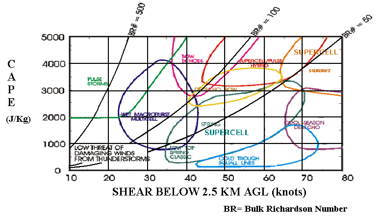
 Conditions favorable for thunderstorm types and complexes
Atmospheric convection is the result of a parcel-environment instability, or temperature difference, layer in the atmosphere. Different lapse rates within dry and moist air lead to instability. Mixing of air during the day which expands the height of the planetary boundary layer leads to increased winds, cumulus cloud development, and decreased surface dewpoints. Moist convection leads to thunderstorm development, which is often responsible for severe weather throughout the world. Special threats from thunderstorms include hail, downbursts, and tornadoes.
Contents
Overview
There are a few general archetypes of atmospheric instability that correspond to convection and lack thereof. Steeper and/or positive lapse rates (environmental air cools quickly with height) suggests atmospheric convection is more likely, while weaker and/or negative environmental lapse rates suggest it is less likely. This is because any displaced air parcels will become more (less) buoyant, given their sign of adiabatic temperature change, in the steep (weak) lapse rate environments.
Convection begins at the Level of Free Convection (LFC), where it begins its ascent through the Free Convective Layer (FCL), and then stops at the equilibrium level. The rising parcel, if having enough momentum, will continue to rise to the Maximum Parcel Level (MPL) until negative buoyancy decelerates the parcel to a stop.
As long as a parcel is convecting, it theoretically will be accelerating. The exception to this is if drag produced by the updraft creates an equal, albeit opposite force to counter that from the buoyancy.[1]. This could be thought of as similar to the terminal velocity of a falling object. This force from buoyancy can be measured by Convective Available Potential Energy (CAPE), or the joules of energy available per kilogram of potentially buoyant air. A theoretical updraft velocity can be derived from this value via substitution into the kinetic energy equation. Although this value will be an underestimation given the aforementioned drag or entrainment effects holding back further acceleration at some point. See the CAPE, buoyancy, and parcel links for a more in depth mathematical explanation of these processes.
Initiation
A thermal column (or thermal) is a vertical section of rising air in the lower altitudes of the Earth's atmosphere. Thermals are created by the uneven heating of the Earth's surface from solar radiation. The Sun warms the ground, which in turn warms the air directly above it. The warmer air expands, becoming less dense than the surrounding air mass, and creating a thermal low.[1][2] The mass of lighter air rises, and as it does, it cools due to its expansion at lower high-altitude pressures. It stops rising when it has cooled to the same temperature as the surrounding air. Associated with a thermal is a downward flow surrounding the thermal column. The downward moving exterior is caused by colder air being displaced at the top of the thermal. Another convection-driven weather effect is the sea breeze.[3][4]
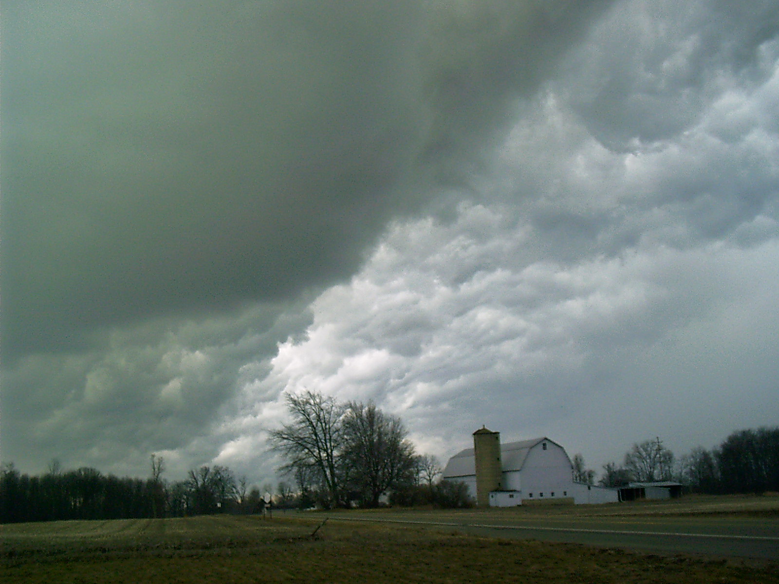
Thunderstorms
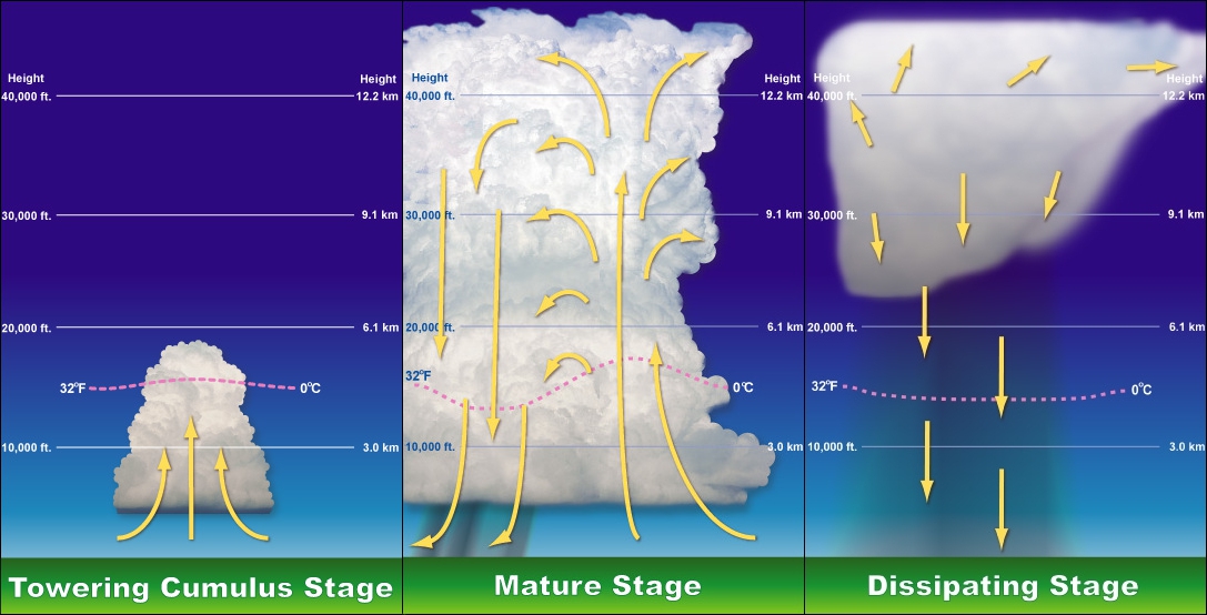
 Stages of a thunderstorm's life.
Warm air has a lower density than cool air, so warm air rises within cooler air,[5] similar to hot air balloons.[6] Clouds form as relatively warmer air carrying moisture rises within cooler air. As the moist air rises, it cools causing some of the water vapor in the rising packet of air to condense.[7] When the moisture condenses, it releases energy known as latent heat of fusion which allows the rising packet of air to cool less than its surrounding air,[8] continuing the cloud's ascension. If enough instability is present in the atmosphere, this process will continue long enough for cumulonimbus clouds to form, which support lightning and thunder. Generally, thunderstorms require three conditions to form: moisture, an unstable airmass, and a lifting force (heat).
All thunderstorms, regardless of type, go through three stages: the developing stage, the mature stage, and the dissipation stage.[9] The average thunderstorm has a 24 km (15 mi) diameter. Depending on the conditions present in the atmosphere, these three stages take an average of 30 minutes to go through.[10]
There are four main types of thunderstorms: single-cell, multicell, squall line (also called multicell line) and supercell. Which type forms depends on the instability and relative wind conditions at different layers of the atmosphere ("wind shear"). Single-cell thunderstorms form in environments of low vertical wind shear and last only 20–30 minutes. Organized thunderstorms and thunderstorm clusters/lines can have longer life cycles as they form in environments of significant vertical wind shear, which aids the development of stronger updrafts as well as various forms of severe weather. The supercell is the strongest of the thunderstorms, most commonly associated with large hail, high winds, and tornado formation.
The latent heat release from condensation is the determinate between significant convection and almost no convection at all. The fact that air is generally cooler during winter months, and therefore can not hold as much water vapor and associated latent heat, is why significant convection (thunderstorms) are infrequent in cooler areas during that period. Thundersnow is one situation where forcing mechanisms provide support for very steep environmental lapse rates, which as mentioned before is an archetype for favored convection. The small amount of latent heat released from air rising and condensing moisture in a thundersnow also serves to increase this convective potential, although minimally.
Boundaries and Forcing
Despite the fact that there might be a layer in the atmosphere that has positive values of CAPE, if the parcel does not reach or begin rising to that level, the most significant convection that occurs in the FCL will not be realized. This can occur for numerous reasons. Primarily, it is the result of a cap, or convective inhibition (CIN/CINH). Processes that can erode this inhibition are heating of the Earth's surface and forcing. Such forcing mechanisms encourage upward vertical velocity, characterized by a speed that is relatively low to what you find in a thunderstorm updraft. Because of this, it is not the actual air being pushed to its LFC that "breaks through" the inhibition, but rather the forcing cools the inhibition adiabatically. This would counter, or "erode" the increase of temperature with height that is present during a capping inversion.
Forcing mechanisms that can lead to the eroding of inhibition are ones that create some sort of evacuation of mass in the upper parts of the atmosphere, or a surplus of mass in the low levels of the atmosphere, which would lead to upper level divergence or lower level convergence, respectively. Upward vertical motion will often follow. Specifically, a cold front, sea/lake breeze, outflow boundary, or forcing through vorticity dynamics (differential positive vorticity advection) of the atmosphere such as with troughs, both shortwave and longwave. Jet streak dynamics through the imbalance of Coriolis and pressure gradient forces, causing subgeostrophic and supergeostrophic flows, can also create upward vertical velocities.There are numerous other atmospheric setups in which upward vertical velocities can be created.
Concerns regarding severe deep moist convection
Buoyancy is key to thunderstorm growth and is necessary for any of the severe threats within a thunderstorm. There are other processes, not necessarily thermodynamic, that can increase updraft strength. These include updraft rotation, low level convergence, and evacuation of mass out of the top of the updraft via strong upper level winds and the jet stream.
Hail
Main article: Hail Hail shaft
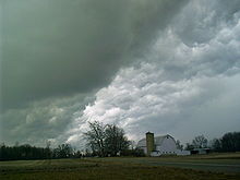 Severe thunderstorms containing hail can exhibit a characteristic green coloration[11]
Like other precipitation in cumulonimbus clouds hail begins as water droplets. As the droplets rise and the temperature goes below freezing, they become supercooled water and will freeze on contact with condensation nuclei. A cross-section through a large hailstone shows an onion-like structure. This means the hailstone is made of thick and translucent layers, alternating with layers that are thin, white and opaque. Former theory suggested that hailstones were subjected to multiple descents and ascents, falling into a zone of humidity and refreezing as they were uplifted. This up and down motion was thought to be responsible for the successive layers of the hailstone. New research (based on theory and field study) has shown this is not necessarily true.
The storm's updraft, with upwardly directed wind speeds as high as 110 miles per hour (180 km/h),[12] blow the forming hailstones up the cloud. As the hailstone ascends it passes into areas of the cloud where the concentration of humidity and supercooled water droplets varies. The hailstone’s growth rate changes depending on the variation in humidity and supercooled water droplets that it encounters. The accretion rate of these water droplets is another factor in the hailstone’s growth. When the hailstone moves into an area with a high concentration of water droplets, it captures the latter and acquires a translucent layer. Should the hailstone move into an area where mostly water vapour is available, it acquires a layer of opaque white ice.[13]
Furthermore, the hailstone’s speed depends on its position in the cloud’s updraft and its mass. This determines the varying thicknesses of the layers of the hailstone. The accretion rate of supercooled water droplets onto the hailstone depends on the relative velocities between these water droplets and the hailstone itself. This means that generally the larger hailstones will form some distance from the stronger updraft where they can pass more time growing[13] As the hailstone grows it releases latent heat, which keeps its exterior in a liquid phase. Undergoing 'wet growth', the outer layer is sticky, or more adhesive, so a single hailstone may grow by collision with other smaller hailstones, forming a larger entity with an irregular shape.[14]
The hailstone will keep rising in the thunderstorm until its mass can no longer be supported by the updraft. This may take at least 30 minutes based on the force of the updrafts in the hail-producing thunderstorm, whose top is usually greater than 10 km high. It then falls toward the ground while continuing to grow, based on the same processes, until it leaves the cloud. It will later begin to melt as it passes into air above freezing temperature[15]
Thus, a unique trajectory in the thunderstorm is sufficient to explain the layer-like structure of the hailstone. The only case in which we can discuss multiple trajectories is in a multicellular thunderstorm where the hailstone may be ejected from the top of the "mother" cell and captured in the updraft of a more intense "daughter cell". This however is an exceptional case.[13]
Downburst
A downburst is created by a column of sinking air that, after hitting ground level, spreads out in all directions and is capable of producing damaging straight-line winds of over 150 mph (240 km/h), often producing damage similar to, but distinguishable from, that caused by tornadoes. This is because the physical properties of a downburst are completely different from those of a tornado. Downburst damage will radiate from a central point as the descending column spreads out when impacting the surface, whereas tornado damage tends towards convergent damage consistent with rotating winds. To differentiate between tornado damage and damage from a downburst, the term straight-line winds is applied to damage from microbursts.
Downbursts are particularly strong downdrafts from thunderstorms. Downbursts in air that is precipitation free or contains virga are known as dry downbursts;[16] those accompanied with precipitation are known as wet downbursts. Most downbursts are less than 2.5 miles (4 km) in extent: these are called microbursts.[17] Downbursts larger than 2.5 miles (4 km) in extent are sometimes called macrobursts.[17] Downbursts can occur over large areas. In the extreme case, a derecho can cover a huge area more than 200 miles (320 km) wide and over 1000 miles (1600 km) long, lasting up to 12 hours or more, and is associated with some of the most intense straight-line winds,[18] but the generative process is somewhat different from that of most downbursts.
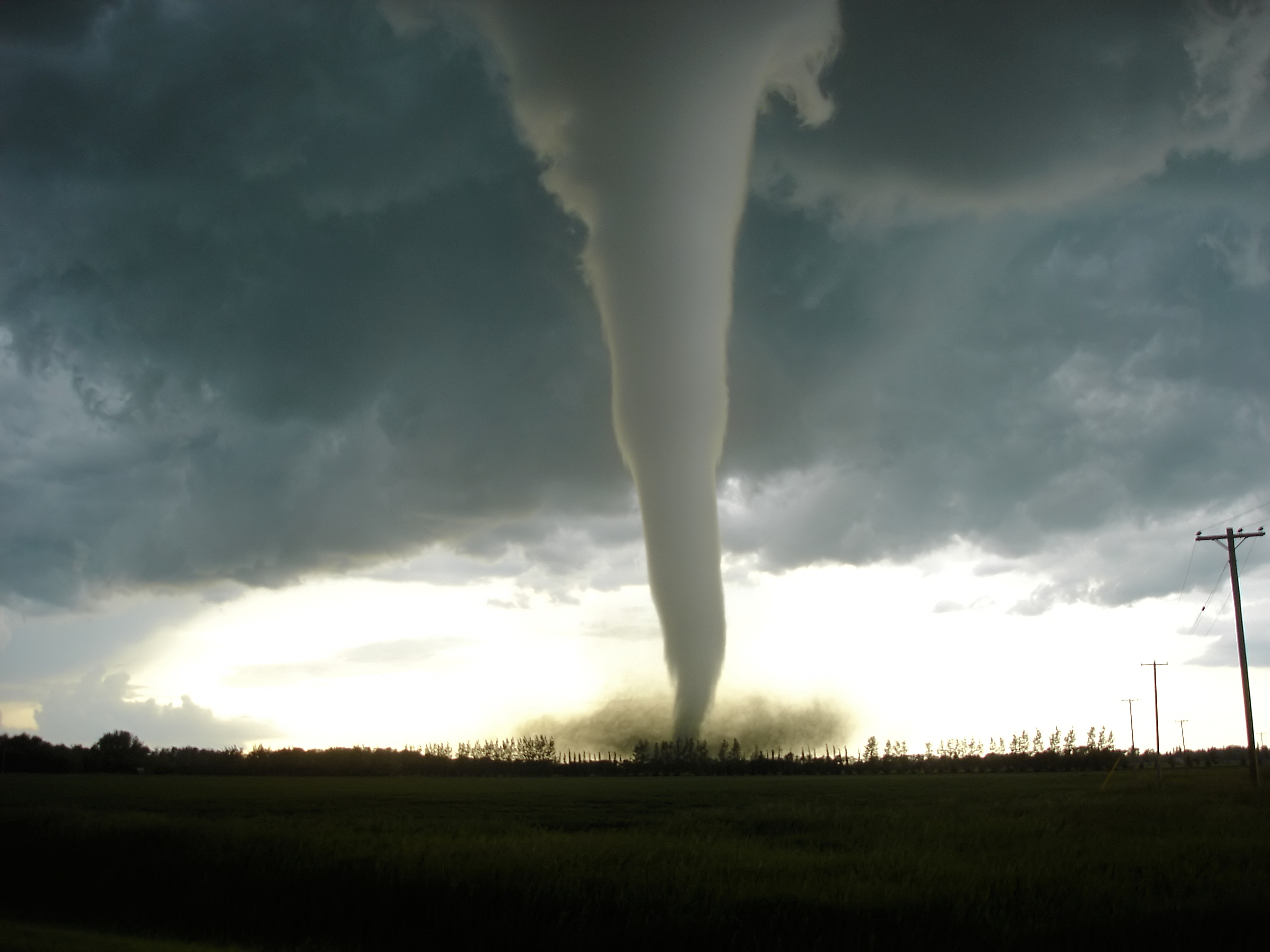
Tornadoes
Main article: Tornado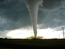 The F5 tornado that struck Elie, Manitoba in 2007.
A torando is a dangerous rotating column of air in contact with both the surface of the earth and the base of a cumulonimbus cloud (thundercloud) or a cumulus cloud, in rare cases. Tornadoes come in many sizes but typically form a visible condensation funnel whose narrowest end reaches the earth and surrounded by a cloud of debris and dust.[19]
Tornadoes wind speeds generally average between 40 miles per hour (64 km/h) and 110 miles per hour (180 km/h). They are approximately 250 feet (76 m) across and travel a few miles (kilometers) before dissipating. Some attain wind speeds in excess of 300 miles per hour (480 km/h), may stretch more than a mile (1.6 km) across, and maintain contact with the ground for dozens of miles (more than 100 km).[20][21][22]
Tornadoes, despite being one of the most destructive weather phenomena are generally short-lived. A long-lived tornado generally lasts no more than an hour, but some have been known to last for 2 hours or longer (for example, the Tri-state tornado). Due to their relatively short duration, less information is known about the development and formation of tornadoes.[23]
Measurement
The potential for convection in the atmosphere is often measured by an atmospheric temperature/dewpoint profile with height. This is often displayed on a Skew-T chart or other similar thermodynamic diagram. These can be plotted by a measured sounding analysis, which is the sending of a radiosonde attached to a balloon into the atmosphere to take the measurements with height. Forecast models can also create these diagrams, but are less accurate due to model uncertainties and biases, and have lower spatial resolution. Although, the temporal resolution of forecast model soundings is greater than the direct measurements, where the former can have plots for intervals of up to every 3 hours, and the latter as having only 2 per day (although when a convective event is expected a special sounding might be taken outside of the normal schedule of 00Z and then 12Z.).[2]
Other forecasting concerns
Atmospheric convection can also be responsible for and have implications on a number of other weather conditions. A few examples on the smaller scale would include: Convection mixing the planetary boundary layer (PBL) and allowing drier air aloft to the surface thereby decreasing dewpoints, creating cumulus type clouds which can limit a small amount of sunshine, increasing surface winds, making outflow boundaries/and other smaller boundaries more diffuse, and the eastward propagation of the dryline during the day. On the larger scale, rising of air can lead to warm core surface lows, often found in the desert southwest.
See also
References
- ^ National Weather Service Forecast Office in Tucson, Arizona (2008). "What is a monsoon?". National Weather Service Western Region Headquarters. http://www.wrh.noaa.gov/twc/monsoon/monsoon_whatis.php. Retrieved 2009-03-08.
- ^ Douglas G. Hahn and Syukuro Manabe (1975). "The Role of Mountains in the South Asian Monsoon Circulation". Journal of Atmospheric Sciences 32 (8): 1515–1541. Bibcode ...32.1515H 1975JAtS ...32.1515H. doi:10.1175/1520-0469(1975)032<1515:TROMIT>2.0.CO;2. ISSN 1520-0469.
- ^ University of Wisconsin. Sea and Land Breezes. Retrieved on 2006-10-24.
- ^ JetStream: An Online School For Weather (2008). The Sea Breeze. National Weather Service. Retrieved on 2006-10-24.
- ^ Albert Irvin Frye (1913). Civil engineers' pocket book: a reference-book for engineers, contractors. D. Van Nostrand Company. p. 462. http://books.google.com/?id=PDtIAAAAIAAJ&pg=PA462&lpg=PA462&dq=density+varies+by+temperature+book&q=. Retrieved 2009-08-31.
- ^ Yikne Deng (2005). Ancient Chinese Inventions. Chinese International Press. pp. 112–13. ISBN 9787508508375. http://books.google.com/?id=ssO_19TRQ9AC&pg=PA112&dq=Kongming+balloon. Retrieved 2009-06-18.
- ^ FMI (2007). "Fog And Stratus – Meteorological Physical Background". Zentralanstalt für Meteorologie und Geodynamik. http://www.zamg.ac.at/docu/Manual/SatManu/main.htm?/docu/Manual/SatManu/CMs/FgStr/backgr.htm. Retrieved 2009-02-07.
- ^ Chris C. Mooney (2007). Storm world: hurricanes, politics, and the battle over global warming. Houghton Mifflin Harcourt. p. 20. ISBN 9780151012879. http://books.google.com/?id=RRSzR4NQdGkC&pg=PA20&lpg=PA20&dq=cloud+formation+latent+heat+book&q=. Retrieved 2009-08-31.
- ^ Micheal H. Mogil (2007). Extreme Weather. New York: Black Dog & Leventhal Publisher. pp. 210–211. ISBN 978-1-57912-743-5.
- ^ National Severe Storms Laboratory (2006-10-15). "A Severe Weather Primer: Questions and Answers about Thunderstorms". National Oceanic and Atmospheric Administration. http://www.nssl.noaa.gov/primer/tstorm/tst_basics.html. Retrieved 2009-09-01.
- ^ Frank W. Gallagher, III. (October 2000). "Distant Green Thunderstorms - Frazer's Theory Revisited". Journal of Applied Meteorology (American Meteorological Society) 39 (10): 1754. Bibcode 2000JApMe..39.1754G. doi:10.1175/1520-0450-39.10.1754. http://journals.ametsoc.org/doi/pdf/10.1175/1520-0450-39.10.1754. Retrieved 2011-01-20.
- ^ National Center for Atmospheric Research (2008). "Hail". University Corporation for Atmospheric Research. http://www.ncar.ucar.edu/research/meteorology/storms/hail.php. Retrieved 2009-07-18.
- ^ a b c Stephan P. Nelson (August 2003). "The Influence of Storm Flow Struce on Hail Growth". Journal of Atmospheric Sciences 40 (8): 1965–1983. Bibcode 1983JAtS...40.1965N. doi:10.1175/1520-0469(1983)040<1965:TIOSFS>2.0.CO;2. ISSN 1520-0469. http://journals.ametsoc.org/doi/pdf/10.1175/1520-0469%281983%29040%3C1965%3ATIOSFS%3E2.0.CO%3B2.
- ^ Julian C. Brimelow, Gerhard W. Reuter, and Eugene R. Poolman (October 2002). "Modeling Maximum Hail Size in Alberta Thunderstorms". Weather and Forecasting 17 (5): 1048–1062. Bibcode 2002WtFor..17.1048B. doi:10.1175/1520-0434(2002)017<1048:MMHSIA>2.0.CO;2. ISSN 1520-0434.
- ^ Jacque Marshall (2000-04-10). "Hail Fact Sheet". University Corporation for Atmospheric Research. http://www.ucar.edu/communications/factsheets/Hail.html. Retrieved 2009-07-15.
- ^ Fernando Caracena, Ronald L. Holle, and Charles A. Doswell III. Microbursts: A Handbook for Visual Identification. Retrieved on 9 July 2008.
- ^ a b Glossary of Meteorology. Macroburst. Retrieved on 30 July 2008.
- ^ Peter S. Parke and Norvan J. Larson. Boundary Waters Windstorm. Retrieved on 30 July 2008.
- ^ Renno, Nilton O. (August 2008). "A thermodynamically general theory for convective vortices" (PDF). Tellus A 60 (4): 688–99. Bibcode 2008TellA..60..688R. doi:10.1111/j.1600-0870.2008.00331.x. http://vortexengine.ca/misc/Renno_2008.pdf.
- ^ Edwards, Roger (2006-04-04). "The Online Tornado FAQ". Storm Prediction Center. http://www.spc.noaa.gov/faq/tornado. Retrieved 2006-09-08.
- ^ "Doppler On Wheels". Center for Severe Weather Research. 2006. http://cswr.org/dow/DOW.htm. Retrieved 2006-12-29.
- ^ "Hallam Nebraska Tornado". Omaha/Valley, NE Weather Forecast Office. 2005-10-02. http://www.crh.noaa.gov/oax/archive/hallam/hallam.php. Retrieved 2006-09-08.
- ^ "Tornadoes". 2008-08-01. http://www.windows.ucar.edu/tour/link=/earth/Atmosphere/tornado.html&edu=high. Retrieved 2009-08-03.
Categories:- Severe weather and convection
- Atmospheric thermodynamics

Wikimedia Foundation. 2010.