- January 2008 tornado outbreak sequence
-
January 2008 tornado outbreak sequence Extensive tornado damage in Southeastern Wisconsin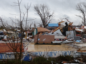
Date of tornado outbreak: January 7 – January 11, 2008 Duration1: 3 days, 11 hours, 48 minutes Maximum rated tornado2: EF3 tornado Tornadoes caused: 75 confirmed Damages: $88 million (+ $41 million non–tornadic)[1] Fatalities: 4 Areas affected: Parts of the Central and Southern United States 1Time from first tornado to last tornado
2Most severe tornado damage; see Enhanced Fujita ScaleThe January 2008 tornado outbreak sequence was an unseasonably strong tornado outbreak that began on January 7, 2008 and continued for nearly four days, with the hardest hit area being southwestern Missouri, northwestern Arkansas and the surrounding area. In addition, a strong supercell in northern Illinois and southeastern Wisconsin produced that region's first January tornadoes since 1967.[2]
More tornadoes occurred across the Mississippi Valley on January 8 and after a break in the activity on January 9, another round of severe weather took place in the Southern United States (primarily Alabama and Mississippi) on January 10. Several damaging tornadoes were reported that day, although no one was killed. In total, over the four–day period, at least 74 tornadoes were confirmed and four people were killed.
Contents
Meteorological synopsis
An unseasonably warm air mass was entrenched over much of central and eastern North America with record highs for much of the region. Several record high temperatures were broken across several states and Canadian provinces from January 7 to January 9 as temperatures rose into the 70s (21-25°C) as far north as the Ohio Valley with dewpoints in the high 50s and low 60s (14-17°C) providing additional fuel for storm development.
In addition, many areas near the Great Lakes region reached the mid to upper 60s (17-20°C) which allowed the northern cells to form, while several areas in southern Ontario and Quebec near the Canada-US border reached near 60°F (16°C).[3][4]
 Tornado tracks across Southern Missouri on January 7–8 (Courtesy of NWS Springfield, Missouri)
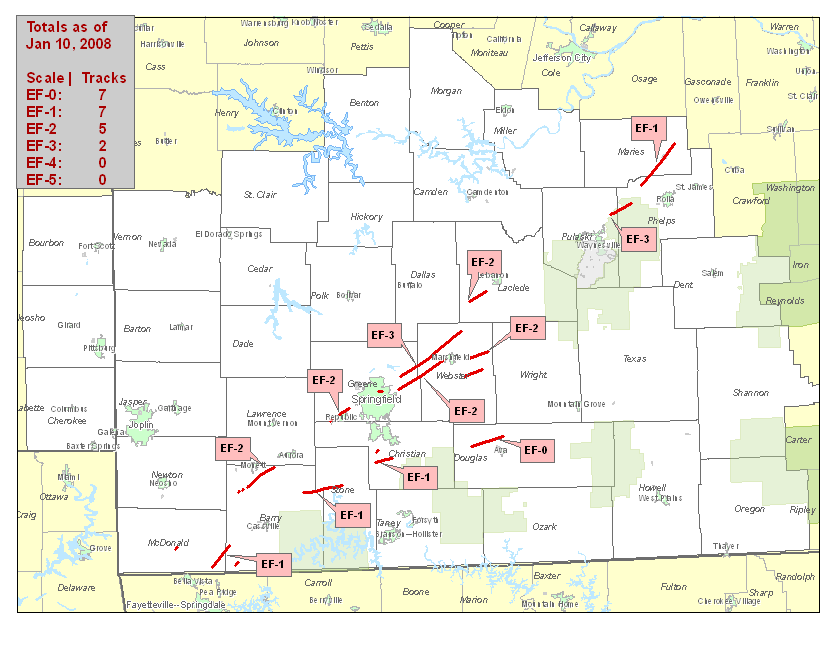
A strong low pressure area over the central Great Lakes and its associated cold front combined with intense wind shear to provide a favorable environment for supercell development.[5] Despite only moderate instability (which meant only a slight risk of severe weather was issued by the Storm Prediction Center, and only modest probabilities for severe weather at first[6]), supercells developed throughout the day over much of the central US and continued throughout the evening and overnight hours, continuing into the morning of January 8. The hardest-hit area was in the Ozarks, around Springfield, Missouri, where nearly continuous supercells developed throughout the evening, resulting in numerous tornado touchdowns. In addition to the tornadoes, hail larger than baseballs and damaging straight-line downburst winds as strong as 100 mph (160 km/h) were reported. At least three people were killed in Missouri as a result of the tornadoes. Two of these deaths occurred near Marshfield and there were also six injuries.[7]
Strong tornadoes also touched down further north near Chicago and Milwaukee causing extensive damage along the Wisconsin/Illinois border as well as several injuries. Strong cells and lines also formed in Michigan prompting rare tornado warnings across central parts of Lower Michigan.[8] Scattered thunderstorms were reported in Northern, Central and Southern Ontario on the evening of January 7.[9] Tornado watches extended from eastern Oklahoma to southwestern Ontario on January 7.[10]
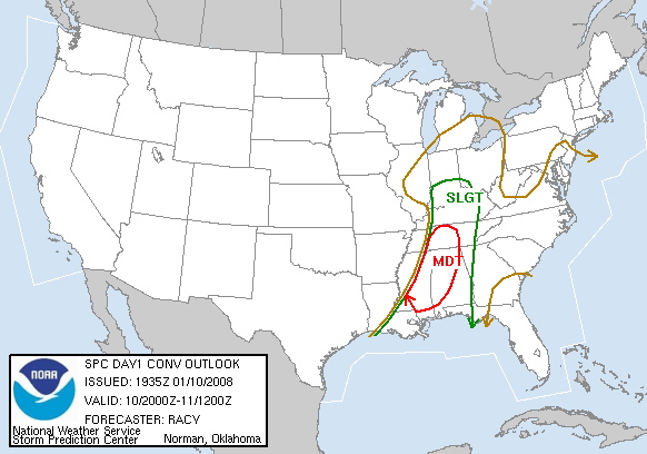
 SPC Severe Weather Forecast for January 10, 2008 showing the moderate risk area. (Courtesy of NWS Birmingham, Alabama)
Activity shifted across the Mid-Mississippi Valley on January 8 where tornado watches were issued across Arkansas and Tennessee and later extended across the Ohio Valley to near Columbus, Ohio and Dayton, Ohio until the early morning hours on January 9. A strong tornado in Pope County, Arkansas killed at least one person and additional tornadoes were reported just west of Memphis. During the day, most of the activity was formed into a line that extended from the Ohio Valley to Alabama although thunderstorm-related wind damage was reported as far north as upstate New York and western Pennsylvania.
After a lull in activity on January 9, a separate system across the Southern United States led to more severe weather, including tornadoes, on January 10. A moderate risk of severe weather was issued by the Storm Prediction Center.
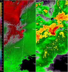 NEXRAD view of a supercell near Caledonia, Mississippi, displaying relative velocity on the left, and base reflectivity on the right. (Courtesy of NWS Jackson, Mississippi)
Storms developed across Louisiana and Mississippi during the morning and noon periods moving into Alabama with additional storms developing as far north as central and eastern Kentucky where a tornado watch was issued stretching down towards eastern Louisiana and later into Georgia. One particular storm produced several tornado reports across Attala County and near Starkville with some structural damage.
At around 2:20 PM CDT, a tornado warning was issued for Lamar County, Alabama after a report of significant structural damage was received in Caledonia, Mississippi in Lowndes County; a tornado was later spotted by the emergency management in the downtown Vernon, Alabama area. Additional tornadoes were reported from a storm that moved from southeastern Mississippi to north of Tuscaloosa later in the afternoon causing extensive damage in northeastern portion of Tuscaloosa County. More stable air farther east reduced the severe weather potential. Wintry weather including snow, sleet and freezing rain on the northern side of the storm was reported from Wisconsin to Maine on January 10–11.
Tornadoes confirmed
Confirmed
TotalConfirmed
EF0Confirmed
EF1Confirmed
EF2Confirmed
EF3Confirmed
EF4Confirmed
EF575 32 28 7 8 0 0 January 7 event
List of reported tornadoes - Monday, January 7, 2008 EF# Location County Time (UTC) Path length Damage Missouri EF0 SW of Lowry City St. Clair 2022 unknown Brief tornado touchdown by spotter with damage to a few trees. EF0 SE of Lincoln Benton 2054 unknown Report from a local newspaper. Photographs revealed that a pole barn was heavily damaged. EF0 NE of Auxvasse Audrain 2155 0.5 mile
(800 m)EF2 N of Purdy Barry 2306 12 miles
(19.2 km)Damage reported by Monett Police at the corner of Route BB and Route 37. Tornado destroyed a barn and part of a mobile home park. EF0 E of Pineville McDonald 2350 0.1 mile
(160 m)Minimal damage, primarily to trees. EF2 SW of Republic Greene 2357 6 miles
(9.6 km)A pole barn was destroyed. Numerous homes, as well as an elementary school, were badly damaged. Previously were two separate tornado tracks before being combined into a single track. EF0 W of Purdy (1st tornado) Barry 0020 0.1 mile
(160 m)Brief tornado destroyed a mobile home. EF0 W of Purdy (2nd tornado) Barry 0020 0.1 mile
(160 m)Another brief tornado touchdown destroyed a pole barn. EF0 W of Purdy (3rd tornado) Barry 0020 0.5 mile
(800 m)Third tornado in the same area destroyed a barn. EF3 Strafford area (1st tornado) Greene, Webster, Laclede 0029 26 miles
(42 km)3 deaths - Over 50 houses were damaged or destroyed, along with many barns and outbuildings. Fatalities occurred near Strafford and Sampson. Six others were injured. EF0 NE of Aurora Lawrence, Christian 0128 6 miles
(9.6 km)Heavy damage to a barn where a cow was killed. Farm houses and outbuildings were also damaged. EF2 Strafford area (2nd tornado) Greene, Webster 0132 17 miles
(29 km)Power flashes reported. Several houses and outbuildings were damaged or destroyed. EF0 S of Mount Sterling Gasconade 0150 0.25 mile
(400 m)Brief tornado touchdown with some tree damage. EF3 Jerome area Pulaski, Phelps 0206 7 miles
(11 km)Significant damage reported in the area with numerous buildings destroyed, including several houses. Extensive tree damage in the area. Three people were injured. EF1 NW of Mayflower McDonald, Barry 0215 7 miles
(11.2 km)A few structures were heavily damaged or destroyed. Several trees were damaged. EF0 W of Clarksville Pike 0230 5 miles
(8 km)Intermittent tornado touchdown with some tree damage. EF1 NE of Marshfield Webster, Dallas 0242 6 miles
(9.6 km)One house was damaged along with a few outbuildings. EF2 NW of Phillipsburg Laclede 0300 5 miles
(8 km)Several outbuildings were destroyed and one house was heavily damaged. Numerous trees were uprooted. EF0 W of Seligman Barry 0312 20 yds
(18 m)Very short-lived tornado knocked a few trees down. EF1 NW of Highlandville Christian 0336 1.5 miles
(2.4 km)Two mobile homes were destroyed and several houses were damaged. One person was injured. EF1 Vichy area Phelps, Maries 0340 13 miles
(21 km)10 houses were damaged, along with an unoccupied school building. Over 20 outbuildings were damaged or destroyed, and a mobile home was also destroyed. The Vichy recording station reported wind gusts of 97 mph (155 km/h). One person was injured. EF0 E of Marshfield Webster 0357 11 miles
(17 km)A mobile home lost its roof and a barn was destroyed. EF1 W of Washburn McDonald, Barry 0421 9 miles
(15 km)Damage limited to trees. Illinois EF3 Lawrence area Boone, McHenry 2130 13.2 miles
(21 km)Seventeen homes, and several barns were destroyed and many other buildings were damaged. live stock were killed and several injured, The tornado also derailed a train on the Union Pacific Railroad carrying hazardous materials, forcing a local evacuation. Five people were injured. It was the first tornado in northeastern Illinois in the month of January since 1950.[11] The derailment of the train was recorded by the trains on-board surveillance box camera.[12] EF1 S of Mackinaw Tazewell 2322 3 miles
(4.8 km)A pole barn was destroyed and a home and a few outbuildings were damaged. A chain link fence and tree limbs were blown down. EF0 SE of Pleasant Hill Pike 0240 2.75 miles
(4.4 km)Intermittent tornado touchdown with some tree damage. Wisconsin EF3 New Munster area Walworth, Kenosha 2202 10.8 miles
(17 km)The northernmost January tornado in the US since 1967 damaged over 150 houses, including 27 houses completely destroyed, with a few weaker structures flattened, and 32 others heavily damaged. 15 people were injured but no injuries were serious. EF1 Kenosha Kenosha 2239 2.4 miles
(3.9 km)Tornado damaged an apartment building in the northern fringes of the city, in which the second story suffered damage. Several houses suffered minor to moderate damage and some trees damaged.[13] Arkansas EF0 S of Hiwasse Benton 0205 unknown EF0 E of Centerton Benton 0250 unknown EF1 SW of Decatur Benton 0509 2.6 miles
(4.2 km)Several trees heavily damaged, but no buildings impacted. Oklahoma EF0 SW of Watts Adair 0208 unknown EF0 N of Moodys Cherokee 0428 unknown Brief touchdown resulted in minor damage to one house and two barns. EF0 NE of Porter Wagoner 0538 1 miles
(1.6 km)Extensive tree damage. EF0 NE of Wagoner Wagoner 0554 2.7 miles
(4.4 km)Damage limited to a few trees. Sources: Storm reports of January 7, 2008, NWS Milwaukee, NWS Springfield, KY3 News, NWS Chicago, NWS St. Louis, NWS Tulsa
January 8 event
List of reported tornadoes - Tuesday, January 8, 2008 EF# Location County Time (UTC) Path length Damage Missouri EF1 NE of Washburn Barry 0822 7 miles
(11 km)Several structures and trees damaged. EF1 E of Cassville Barry, Stone 0831 14 miles
(22 km)Several poultry barns were damaged, along with numerous sheds and outbuildings. EF1 Springfield Greene 0837 1 mile
(1.6 km)Spotter reported tornado on the ground in central Springfield that moved across the northern part of the downtown area near Chestnut Expressway and Sherman Avenue. A warehouse owned by the Harry S. Cooper Supply Company collapsed. EF1 Highlandville Christian 0850 5 miles
(8 km)Tornado tracked through town damaging several roofs and destroying numerous outbuildings. EF0 S of Branson Taney 0901 100 yds
(90 m)Brief tornado touchdown in the Thousand Hills Resort. Three condominiums were damaged. EF0 SW of Bracken to SW of Susanna Webster 0916 7 miles
(11.2 km)Weak tree and structure damage EF0 SW of Tigris to SE of Mount Zion Douglas 0917 10 miles
(16 km)Barns and outbuildings were damaged or destroyed EF2 S of Niangua Webster 0918 5 miles
(8 km)Several homes and outbuildings were destroyed EF1 SW of Mountain Grove Douglas 0943 1.5 miles
(2.4 km)One mobile home was torn from its foundation. A barn and some outbuildings were damaged. Significant tree damage. EF1 SE of Dawson to SE of Bado Wright, Texas 0945 12 miles
(19.2 km)A few barns and outbuildings were damaged EF0 W of West Plains Howell 1020 unknown Brief tornado touchdown reported. EF1 SW of Eminence Shannon 1027 1.5 miles
(2.4 km)Numerous trees were snapped or uprooted, but no structures impacted. EF1 NE of Eminence Shannon 1038 10 miles
(16 km)Two barns and a garage were destroyed, and another barn was damaged. Widespread tree damage. Initially were two separate tornado tracks EF0 SW of Alton Oregon 1059 1 mile
(1.6 km)Significant damage reported to three industrial buildings along Route 19. EF1 NE of Essex Stoddard 1840 4.2 miles
(6.8 km)A shed and three outbuildings destroyed and a house was damaged. About 10 power poles snapped. Arkansas EF2 Appleton area Pope, Conway, Van Buren 1440 20.5 miles
(33 km)1 death - Major structural damage reported in the area, with 10 houses destroyed and about 40 others damaged. Many other buildings were damaged or destroyed, including a church. Significant tree damage also reported. Two others were injured by the tornado.[14][15] EF0 SE of Princedale to SE of Twist Cross 1926 11 miles
(17.6 km)A mobile home lost its roof, farm water rig pivots were blown over and trees and power lines were knocked down EF1 S of Deckerville Poinsett 1952 250 yds
(225 m)Brief touchdown damaged two houses and destroyed a shed. EF1 S of Osceola Mississippi 2020 3.5 miles
(5.6 km)Several houses sustained roof damaged. Several people were trapped but rescued. Tennessee EF1 Poplar Grove area Lauderdale, Dyer 2058 7 miles
(11 km)Several houses were severely damaged and one mobile home was destroyed. Extensive tree damage. Mississippi EF0 S of Church Hill Jefferson 2130 4 miles
(6.4 km)Tornado remained in a rural area but tree damage reported along the Natchez Trace Parkway. EF1 Harrisville area Simpson 2337 20 miles
(32 km)Long-track tornado damaged several houses, including roofs blown off at least two houses. Widespread tree damage along the track. EF0 SE of Puckett Rankin 0011 unknown One house suffered shingle damage and some tree damage reported. Sources: Storm reports of January 8, 2008, NWS Little Rock, NWS Paducah, NWS Jackson (MS), NWS Memphis
January 10 event
List of reported tornadoes - Thursday, January 10, 2008 EF# Location County/
ParishTime (UTC) Path length Damage Mississippi EF1 SE of Rocky Springs Claiborne 1727 4 miles
(6.4 km)Tornado remained in a rural area with heavy tree damage but no buildings impacted. EF3 Goodman area Attala, Holmes 1751 10 miles
(16 km)Damage reported to some homes in Goodman according to ABC 33/40 coverage. Numerous houses damaged or destroyed, and hundreds of trees and powerlines down including high-tension towers by a 3/4 mile (1.2 km) wide wedge tornado. One person was injured. EF3 S of Ackerman Attala, Choctaw 1828 24 miles
(38 km)Large wedge tornado destroyed one house, a cinder block structure, a dairy barn and several other structures. A trailer was lifted and flipped onto the roof of a farm building. Three people were injured. EF0 N of Fannin Rankin 1839 1.5 miles
(2.4 km)Tornado damaged some pine trees. EF0 SW of Pearl River Resort Neshoba 1942 2 miles
(3.2 km)Two homes were damaged, one with porch damage and one with roof damage. EF1 S of Iuka Tishomingo 1954 3.5 miles
(5.6 km)Tornado touched down at a landfill site, then damaged two houses and two outbuildings and knocked down many trees. EF3 Caledonia to NE of Malloy (AL) Lowndes, Lamar (AL) 2013 14 miles
(22.4 km)Major damage reported in Caledonia according to ABC 33/40 coverage. A middle school gymnasium was destroyed, as well as several school buses and nearby houses. 10 people were injured. In Alabama, the tornado destroyed two barns, moved the foundations of two mobile homes and damaged two other homes. Initially was two separate tornado tracks with the other being a 5-mile EF2 north of Vernon in Lamar County. EF1 NW of Prairie Point Noxubee 2058 1.5 mile
(2.4 km)Damage limited to downed power poles EF0 N of Prairie Point Noxubee 2102 1 mile
(1.6 km)Damage to a few trees Alabama EF0 Dixons Mills Marengo 1908 800 yds
(750 m)Minor damage reported to four houses, and some trees knocked down. EF0 Pickensville Pickens 2140 unknown Brief tornado damaged the roof of a barn. EF1 E of Gordo Pickens, Tuscaloosa 2145 1.76 miles
(2.8 km)One barn was destroyed and numerous chicken houses were damaged. EF3 E of Windham Springs Jefferson, Walker 2220 4.9 miles
(7.8 km)Tornado reported on the ground according to ABC 33/40 coverage. It touched down west of Oak Grove. Significant damage to trees, homes, a grocery store and a church. Louisiana EF1 W of New Roads Pointe Coupee 1910 0.25 mile
(400 m)Brief tornado with minor to moderate damage at several industrial buildings at the intersection of Highways 1 and 3131. Kentucky EF1 SW of Park City Barren 2002 1.8 miles
(3 km)Tornado sighted just outside the town. Tennessee EF2 E of Waynesboro Wayne 2055 1.29 miles
(2.1 km)A metal barn was completely destroyed and several others suffered heavy damage. Minor damage to a few houses. Sources: Storm reports of January 10, 2008 NWS Birmingham, NWS New Orleans, NWS Jackson (MS), NWS Jackson (MS) Preliminary Storm Report, NWS Nashville, NWS Louisvlle
January 11 event
List of reported tornadoes - Friday, January 11, 2008 EF# Location County/
ParishTime (UTC) Path length Damage Alabama EF1 S of Blue Springs Barbour 0700 3.5 miles
(5.6 km)Late report found in surveys on February 19 while repairs were underway. Four houses and a mobile home were damaged, and trees were damaged in the area. Sources: Non-tornadic events
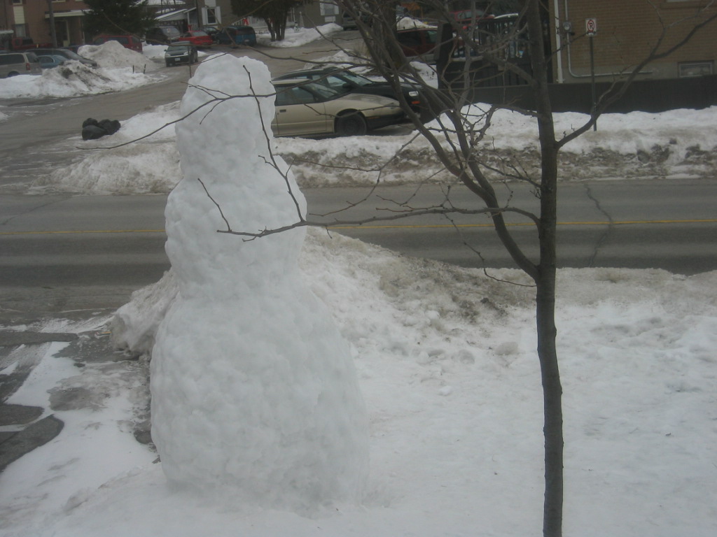
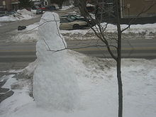 An image of a snowman taken three weeks prior to the melt.
The storm system was also responsible for heavy flooding rains across much of the Midwest from Michigan to Missouri as well as dense fog across Wisconsin, Ontario and Quebec which was caused by rapid snow melt stemming from the January thaw.[16] flooding was reported across several towns and roads which forced the evacuation of some residents. Record-breaking temperatures were reported all across Southern Ontario and surrounding areas.[17][18][19][20][21][22][23][24][25][26][27] The thick fog lead to numerous accidents including two pile-ups involving in total 100 vehicles on Interstate 90 near Madison, Wisconsin which killed at least two and injured dozens more while additional fatal accidents occurred elsewhere.[28] It also disrupted air travel across several airports.[29] Rainfall had exceeded locally 4 inches (100 mm) of rain from Missouri to Indiana and Michigan.
High winds and rain have battered Central, southern and eastern Ontario and southern and central Quebec on January 8, and 9. Power outages and wind damages were reported in some areas. As much as 140,000 Hydro One customers were without power in Ontario and at least 100,000 Hydro-Québec customers in Quebec. Winds were gusting in near on in excess of 100 km/h in some localities including the Greater Toronto Area while the highest peak being 133 km/h recorded near Sandbanks Provincial Park in Prince Edward County. One tractor trailer was overturned and nearly fell into the Saint Lawrence River on the Ogdensburg-Prescott International Bridge[30][31][32][33][34]
See also
- 1967 St. Louis tornado outbreak - Similar rare tornado outbreak in January in the Midwest
- List of North American tornadoes and tornado outbreaks
- List of tornadoes striking downtown areas
- Tornadoes of 2008
References
- ^ "Storm Events". Storm Event Database. National Climatic Data Center (NCDC). January 10, 2008. http://www4.ncdc.noaa.gov/cgi-win/wwcgi.dll?wwevent~storms. Retrieved 2008-06-19.
- ^ "January Twisters Hit Southeastern Wisconsin". Associated Press. January 7, 2008. http://www.todaystmj4.com/news/local/13507322.html. Retrieved 2008-06-19.
- ^ The Sudbury Star - Ontario, CA
- ^ Timmins Daily Press - Ontario, CA
- ^ Storm Prediction Center Jan 7, 2008 1300 UTC Day 1 Convective Outlook
- ^ Storm Prediction Center Jan 7, 2008 0600 UTC Day 1 Convective Outlook
- ^ http://www.kmbc.com/news/14998696/detail.html
- ^ Mt. Pleasant Morning Sun
- ^ The North Bay Nugget - Ontario, CA
- ^ Tornado watch in effect for Windsor-Essex County
- ^ Tornadoes of January 7, 2008
- ^ Train vs. Tornado - Spectacular! Youtube video
- ^ January Tornadoes Touch Down In Kenosha County - Milwaukee Weather News Story - WISN Milwaukee
- ^ ArkansasMatters.com - One Man Dead, One Woman Injured in Pope County, Officials Say
- ^ All Products by Site - NOAA's National Weather Service
- ^ Highway 69 at Pointe Au Baril reopens, Highway 537 still closed
- ^ "Winter flood forces evacuation of Quebec town". CBC News. January 8, 2008. http://www.cbc.ca/canada/montreal/story/2008/01/08/qc-winterthaw0108.html.
- ^ The North Bay Nugget - Ontario, CA
- ^ The North Bay Nugget - Ontario, CA
- ^ Flooding causes closure of Hwy 537
- ^ Wingrove, Josh (January 10, 2008). "Flooding forces evacuations in Huntsville". The Star (Toronto). http://www.thestar.com/News/article/292875. Retrieved May 5, 2010.
- ^ More flood threats across Quebec
- ^ CTV Toronto | CTV News, Shows and Sports - Canadian Television
- ^ Highway 69 at Pointe Au Baril reopens, Highway 537 still closed
- ^ http://www.northernlife.ca/photogallery/01_10_08/photogallery.asp
- ^ Localized flood emergency declared in Huntsville
- ^ Severe weather hits Muskoka
- ^ KHNL NBC 8 Honolulu Hawaii |Dozens of cars pile up in Wisconsin; 2 dead
- ^ "Flights cancelled as fog rolls in with Ontario thaw". CBC News. January 7, 2008. http://www.cbc.ca/canada/ottawa/story/2008/01/07/ot-flood-080107.html.
- ^ "Hydro crews still dealing with windstorm damage". CBC News. January 11, 2008. http://www.cbc.ca/canada/toronto/story/2008/01/11/hydro-repairs.html.
- ^ "Strong winds to blow away warm spell". CBC News. January 9, 2008. http://www.cbc.ca/canada/toronto/story/2008/01/09/ont-weather.html.
- ^ "Gusts blow power out for thousands in Quebec". CBC News. January 9, 2008. http://www.cbc.ca/canada/montreal/story/2008/01/09/qc-windgusts.html.
- ^ Rush, Curtis (January 10, 2008). "Streets reopen after storm". The Star (Toronto). http://www.thestar.com/News/GTA/article/292697. Retrieved May 5, 2010.
- ^ Todd, Jeffrey (January 10, 2008). "Power still out for thousands in Muskoka". The Star (Toronto). http://www.thestar.com/News/Ontario/article/292820. Retrieved May 5, 2010.
External links
- Rare January Tornado in Northern Illinois Monday Afternoon Rated EF3 (NWS Chicago)
- Pictures and Information For Rare January Tornadoes in Southeast Wisconsin (NWS Milwaukee)
- Severe Weather and Flooding of January 7-8, 2008 (NWS Lincoln IL)
- Summary of Severe Weather/Tornado Surveys January 7th-8th (NWS St. Louis)
- Unusually Early Severe Weather Outbreak Hits the Ozarks (NWS Springfield MO)
- Severe Weather on January 7-8, 2008 (NWS Little Rock)
- Jan 7-8 Severe Weather Event (NWS Tulsa)
- Overview of January 8 storms (NWS Paducah)
- Video of a train being derailed by a tornado near Harvard, IL (Youtube)
Tornado events in Alabama Enigma (1884) • Palm Sunday (1920) • May 1929 • March 1932 • April 1936 • Birmingham (1956) • April 1957 • Super Outbreak (1974) • January 1975 • Birmingham (1977) • Huntsville (1989) • November 1992 • Palm Sunday (1994) • Huntsville (1995) • Birmingham (1998) • Tuscaloosa (2000) • November 2001 • Veterans Day (2002) • Hurricane Katrina (2005) • November 2005 • September 2006 • November 2006 • March 2007 • January 2008 • Super Tuesday (2008) • April 2009 • April 2010 • April 2011Tornado Outbreaks of 2008 January · Vancouver · Super Tuesday · February 16-18 · March blizzard · Atlanta · April 8-11 · April 28 · May 1–2 · Mid-May · Late-May · June · July 7–11 · Europe · TS Fay · Hurricane Gustav · Hurricane Ike · November 15 · December 9-11Categories:- F3 tornadoes
- Tornadoes of 2008
- Tornadoes in Alabama
- Tornadoes in Arkansas
- Tornadoes in Illinois
- Tornadoes in Mississippi
- Tornadoes in Missouri
- Tornadoes in Wisconsin
- 2008 natural disasters in the United States


Wikimedia Foundation. 2010.