- December 2000 Tuscaloosa tornado
-
Tuscaloosa Tornado of 2000 Date of tornado outbreak: December 16, 2000 Duration1: 13 hours Maximum rated tornado2: F4 tornado Tornadoes caused: 24 Damages: $ 35 million[1] Fatalities: 12 Areas affected: Southeastern United States 1Time from first tornado to last tornado
2Most severe tornado damage; see Fujita ScaleThe December 2000 Tuscaloosa tornado was a destructive tornado that hit communities south and east of Tuscaloosa, Alabama on December 16, 2000. The F4 rated tornado caused the deaths of 11 people while injuring over 125 others. It was the strongest tornado to hit the state of Alabama in the month of December since 1950 and the strongest of a moderate tornado outbreak that took place across the Southeastern corner of the United States from Mississippi to North Carolina.
Contents
Tornado event
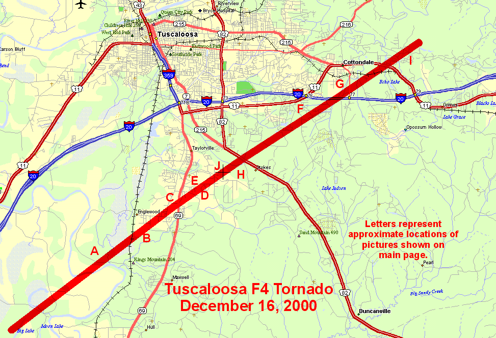
 Tornado track of the Tuscaloosa tornado on December 16, 2000 (courtesy of NWS Birmingham)
The tornado touched down just before 1:00 p.m. CDT near the Black Warrior River in southern Tuscaloosa County and proceeded northeastward for 18 miles (28.8 km) across the communities of Englewood, Hinton Place, Hillcrest Meadows, Bear Creek and Woodland Forest. A tornado emergency was issued for the area before it lifted near Cottondale east of Tuscaloosa near Interstate 20. At its peak intensity, the tornado was about 750 yards wide. The worst damage was located near the Bear Creek area where F4 damage occurred. Near I-20, several commercial buildings including hotels and restaurants were heavily damaged and a shopping center near Route 69 was also hit and partially destroyed. Damage was estimated at over $12 million US (2000 dollars). Over 40 houses and 70 mobile homes were completely destroyed with hundreds more seriously damaged.[2]
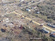 Damage to trees, homes and trailers south of Tuscaloosa
It was one of the deadliest tornadoes to hit the state since the Birmingham F5 tornado that killed 32 people across portions of northwestern Jefferson County on April 8, 1998. That tornado started just northeast of Tuscaloosa during the evening hours demolishing numerous structures south and west of the Birmingham metro area. Since records have being kept in 1950, the Tuscaloosa tornado is the second deadliest tornado in December tied with an F4 tornado near Murphysboro, Illinois in an outbreak on December 18, 1957, that included an F5 storm) and behind the Vicksburg, Mississippi F5 tornado on December 5, 1953 which killed 38. [3]
The 2000 Tuscaloosa tornado was part of a supercell thunderstorm that developed across Mississippi before traveling through western Alabama, then near the Birmingham region before dropping more tornadoes in St. Clair and Etowah counties. Additional tornadoes were confirmed northwest of Birmingham and Jasper.
Tower Cam tornado footage
Outbreak death toll State Total County County
totalAlabama 12 Geneva 1 Tuscaloosa 11 Totals 12 All deaths were tornado-related The tornado was also captured live on the ABC affiliate WBMA/WCFT/WJSU (channels 58, 33 and 40, generally called "ABC 33/40") in Birmingham during a special severe weather bulletin with meteorologists James Spann, Mark Prater, and John Oldshue. The tornado was caught by the station's tower cam located just outside downtown Tuscaloosa along Interstate 20/59 at Woodland Road on U.S. Highway 82. The National Academy of Television Arts and Sciences gave Spann an Emmy Award for the event. The tornado was followed from Englewood to just near its passage south of downtown Tuscaloosa when the reception was lost due to a torrential downpour.
Other tornadoes
Additional tornadoes were reported during the day across the southeastern portion of the US, including in Mississippi, Georgia, Tennessee and the Carolinas. A total of 24 tornadoes were reported on December 16, 2000. One more person was killed by a tornado in Geneva County in southeastern Alabama.
Tornado table
Confirmed
TotalConfirmed
F0Confirmed
F1Confirmed
F2Confirmed
F3Confirmed
F4Confirmed
F524 10 3 9 1 1 0 December 16, 2000
F# Location County Time (EDT) Path length Damage Alabama F2 NW of Geneva Geneva 1034 4.5 miles (7.2 km) 1 death 100 homes were damaged and 5 mobile homes were destroyed including one with the fatality. 9 others were injured. F2 N of Midland Houston, Dale, Henry 1100 29 miles (46.4 km) Several homes in Doe Run subdivision in Pinckard were destroyed. Several other homes and businesses were damaged to varying degrees as well as one church. F1 NW of Wheeler Lake Lawrence, Limestone 1225 5.1 miles (8.2 km) Several outbuildings and boat houses were destroyed while three homes were damaged F2 NW of Athens Limestone 1238 4.8 miles (7.7 km) Three mobile homes were destroyed and several homes were heavily damaged F4 S of Tuscaloosa Tuscaloosa 1254 18 miles (28.8 km) 11 deaths - Seen live on WCFT-TV, tower camera. See this section F0 SE of Marion Perry 1329 0.7 mile (1.1 km) Damage limited to trees F2 S of Ashville St. Clair 1420 8.5 miles (13.6 km) Two mobile homes were destroyed and four homes were damaged F3 NE of Gadsden Etowah, Cherokee 1446 12.8 miles (20.5 km) 250 homes were damaged or destroyed and 14 people were injured F0 S of Bynum Calhoun 1517 0.3 mile (0.5 km) Brief tornado with no damage F0 SW of Deatsville Autauga 1655 0.2 mile (0.32 km) Brief tornado with no damage F0 S of Tallassee Macon 1746 0.7 mile (1.1 km) Two outbuildings and two satellite dishes were destroyed while three homes had minor damage F0 N of Roanoke Randolph 1819 1 mile (1.6 km) Damage limited to trees Mississippi F2 NE of Meridian Lauderdale 1130 12 miles (19.2 km) Two homes, three businesses and three mobile homes were destroyed while 44 homes, 34 mobile homes and one business were also damaged. 17 injuries were reported, including one critical. Florida F0 NE of Freeport Walton 1255 0.2 mile (0.32 km) Damage limited to trees F2 SE of Bonifay Holmes 1324 3 miles (4.8 km) Four mobile homes were destroyed while 4 businesses and 39 homes were damaged F1 SW of Campbellton Jackson 1350 5 miles (8 km) Damage to trees, carports and mobile homes Tennessee F1 NE of Ardmore Lincoln 1308 1.5 miles (2.4 km) One outbuilding was destroyed, one mobile home was heavily damaged and the roof of a cinder block garage was turned about 90 degrees Georgia F2 N of Albany Dougherty 1550 6 miles (9.6 km) Abigail Plantation was heavily affected with several structures damaged while a few homes were also damaged. Storage buildings at a trailer park were also damaged F2 SE of Americus Sumter 2030 10 miles (16 km) A frame house, three barns, several chicken houses and five outbuildings were destroyed. 400 chickens and two cattle were killed. One camper trailer was overturned and one home was damaged. F2 S of Augusta Richmond 2310 2 miles (3.2 km) 8 people were injured as the tornado did extensive damage to a subdivision south of Augusta South Carolina F0 NW of Calhoun Falls Abbeville 2110 0.1 mile (0.16 km) A satellite dish was torn off a house North Carolina F0 W of Spring Lake Cumberland 2300 0.1 mile (0.16 km) Brief tornado with no damage F0 SW of Lillington Harnett 2310 0.1 mile (0.16 km) Some buildings had windows blown off. F0 N of Coats Harnett 2315 0.1 mile (0.16 km) Damage limited to trees and smashed car windows Sources: Storm Data, December 16, 2000 (Tornado History Project) See also
References
- ^ NCDC Storm Events Database Accessed May 7, 2008.
- ^ NCDC: Event Details
- ^ Tornado History Project December tornadoes 1950-2009
External links
- Summary of December 16, 2000 tornado event including Tuscaloosa Tornado
- Map of tornadoes on December 16, 2000
- Storm Summary from NOAA
- Live footage of tornado from ABC 33/40
- Still from the footage to use for picture here please
Tornado events in Alabama Enigma (1884) • Palm Sunday (1920) • May 1929 • March 1932 • April 1936 • Birmingham (1956) • April 1957 • Super Outbreak (1974) • January 1975 • Birmingham (1977) • Huntsville (1989) • November 1992 • Palm Sunday (1994) • Huntsville (1995) • Birmingham (1998) • Tuscaloosa (2000) • November 2001 • Veterans Day (2002) • Hurricane Katrina (2005) • November 2005 • September 2006 • November 2006 • March 2007 • January 2008 • Super Tuesday (2008) • April 2009 • April 2010 • April 2011Categories:- F4 tornadoes
- Tornadoes of 2000
- Tornadoes in Alabama
- Tornadoes in Florida
- Tornadoes in Georgia (U.S. state)
- Tornadoes in Mississippi
- 2000 natural disasters in the United States

Wikimedia Foundation. 2010.