- Clarksville, Missouri
-
Clarksville, Missouri — City — Location of Clarksville, Missouri
Coordinates: 39°22′8″N 90°54′18″W / 39.36889°N 90.905°WCoordinates: 39°22′8″N 90°54′18″W / 39.36889°N 90.905°W Country United States State Missouri County Pike Area - Total 0.8 sq mi (2.1 km2) - Land 0.5 sq mi (1.2 km2) - Water 0.4 sq mi (0.9 km2) Elevation 466 ft (142 m) Population (2000) - Total 490 - Density 1,060.2/sq mi (409.3/km2) Time zone Central (CST) (UTC-6) - Summer (DST) CDT (UTC-5) ZIP code 63336 Area code(s) 573 FIPS code 29-14194[1] GNIS feature ID 0729459[2] 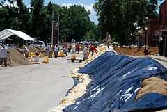 Sandbagging of low lying areas on the Mississippi River, June 2008
Clarksville is a city (which is about the size of a village) in Pike County, Missouri, United States. The population was 490 at the 2000 census.
Contents
History
The city was named for Governor William Clark.[3]
Geography
According to the United States Census Bureau, the city has a total area of 0.8 square miles (2.1 km2), of which, 0.5 square miles (1.3 km2) of it is land and 0.4 square miles (1.0 km2) of it (43.90%) is water.
Demographics
As of the census[1] of 2000, there were 490 people, 225 households, and 134 families residing in the city. The population density was 1,060.2 people per square mile (411.3/km²). There were 278 housing units at an average density of 601.5 per square mile (233.3/km²). The racial makeup of the city was 88.57% White, 7.14% African American, 0.20% Asian, 0.20% Pacific Islander, 1.43% from other races, and 2.45% from two or more races. Hispanic or Latino of any race were 3.06% of the population.
There were 225 households out of which 28.0% had children under the age of 18 living with them, 41.3% were married couples living together, 13.8% had a female householder with no husband present, and 40.4% were non-families. 35.6% of all households were made up of individuals and 15.6% had someone living alone who was 65 years of age or older. The average household size was 2.18 and the average family size was 2.78.
In the city the population was spread out with 25.3% under the age of 18, 8.0% from 18 to 24, 28.0% from 25 to 44, 20.4% from 45 to 64, and 18.4% who were 65 years of age or older. The median age was 36 years. For every 100 females there were 86.3 males. For every 100 females age 18 and over, there were 83.9 males.
The median income for a household in the city was $23,611, and the median income for a family was $29,375. Males had a median income of $29,375 versus $17,292 for females. The per capita income for the city was $14,728. About 22.3% of families and 22.2% of the population were below the poverty line, including 32.2% of those under age 18 and 11.4% of those age 65 or over.
References
- ^ a b "American FactFinder". United States Census Bureau. http://factfinder.census.gov. Retrieved 2008-01-31.
- ^ "US Board on Geographic Names". United States Geological Survey. 2007-10-25. http://geonames.usgs.gov. Retrieved 2008-01-31.
- ^ "Profile for Clarksville, Missouri". ePodunk. http://www.epodunk.com/cgi-bin/genInfo.php?locIndex=20190. Retrieved 2010-06-18.
External links
- Highest landpoints on the Mississippi River
- Historic maps of Clarksville in the Sanborn Maps of Missouri Collection at the University of Missouri
Municipalities and communities of Pike County, Missouri County seat: Bowling Green Cities Bowling Green | Clarksville | Curryville | Frankford | Louisiana

Villages Annada | Ashburn | Eolia | Paynesville | Tarrants
Townships Ashley | Buffalo | Calumet | Cuivre | Hartford | Indian | Peno | Prairieville | Salt River | Spencer
Unincorporated
communitiesCategories:- Missouri populated places on the Mississippi River
- Cities in Pike County, Missouri


Wikimedia Foundation. 2010.