- October 2010 North American storm complex
-
The Superstorm of 2010 Satellite image of the United States, while the storm was at peak intensity.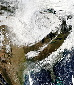
Storm type: Cyclone, Blizzard, Derecho, Tornado outbreak, Windstorm Formed: October 23, 2010 Dissipated: October 28, 2010 Maximum
snow total1:9 inches (22.9 cm) St. Louis County, Minnesota Lowest
pressure:953 mbar (hPa)[1] Snow Damages: {{{total snow damages (USD)}}} Tornado Damages: 18.5 million[2] Snow fatalities: 1 Tornado fatalities: 0 Fujita scale: EF2 tornado Tornadoes: 68 confirmed Areas affected: Eastern two-thirds of North America and adjacent waters 1Maximum snowfall or ice accretion
The October 2010 North American storm complex was a record non-tropical cyclone event occurring across North America. The massive storm complex caused a wide range of weather events including a major serial derecho stretching from the Gulf Coast to the Great Lakes, a widespread tornado outbreak across the Southeast United States and Midwest and a blizzard across portions of the Canadian Prairies and the Dakotas.[1][3] The cyclone's lowest minimum pressure of 953 mbar (28.11") made it the most intense extratropical cyclone ever recorded in the continental United States, surpassing the lowest US pressure of 958 mbar from the Great Ohio Blizzard of 1978.[4]
Contents
Summary of Events
Significant snowfall was reported on the backside of the storm. The heaviest snow fell in parts of Minnesota where 9 inches (22.5 cm) of snow was reported in St. Louis County, Minnesota.[5] Heavy snow and blizzard conditions also occurred in North Dakota, southwestern Manitoba and southeastern Saskatchewan.
The non-tropical cyclonic storm generated wind speeds of up to 70 mph, caused by a severe low pressure zone over Nebraska on October 24th.[6]
This animation shows this extratropical cyclone developing, starting late on October 25 and running through October 27, 2010.
Akron, Cleveland, Findlay, Marion, Lorain, Mansfield, Toledo, Wooster and Youngstown, Ohio all witnessed heavy winds on the 24th.[7]
The American Midwest was hit by an intense low pressure system which would later become an extratropical cyclone (later known as 'Carmen' in Europe[citation needed] after November 8) between October 25 and 27.[8]
Severe weather battered Illinois, Indiana, Michigan, and Ohio on the 25th and 26th of October, producing strong winds, rain, hail, widespread tornadoes and the major 'Chiclone' on the 26th.[6] Severe weather that hit Illinois and Indiana was dubbed a 'Chiclone' (for Chicago+cyclone). It was the region's second strongest storm on record.[6] The weather station in Bigfork, Minnesota recorded a state record atmospheric pressure of 955.2 millibars (28.21 inches of pressure), typical of a Category 3 hurricane.[8] The National Weather Service reported that a tornado with a maximum speed of 115 mph touched down about four miles east of Peotone in Will County, south of Chicago, that morning and traveled 2.9 miles, causing downed power lines and partially destroying a home. Another tornado was reported to have landed in Racine, Wisconsin.[6]
Heavy damage was reported in the Chicago area, particularly in Kane, Will, Kankakee, and Iroquois Counties in Illinois and in Porter County in Indiana. The winds flipped single engine planes on their sides at DuPage Airport in West Chicago, and flights were delayed by 30 minutes at O'Hare and Midway airports.[6] More than 300 flights were canceled at O'Hare International Airport, and more than 60,000 ComEd Co. customers were without power. Several other less powerful tornadoes also occurred in Illinois, Minnesota, Indiana, Wisconsin, Oklahoma, Nebraska and New York. Heavy snow also fell in south western Ontario. There were no fatalities with this system.[6]
A GOES satellite image on October 26 showed what could be considered the eye of the storm over the Minnesota-Ontario border, with outlying clouds reaching as far as Alberta, southern Nunavut, Newfoundland, eastern Montana, Colorado, Louisiana, Maine and Bermuda.[8][8][8]
The storm developed so quickly, that it was declared to be a weather 'bomb', which is an extremely fast developing storm that drops approximately at least one millibar of pressure per hour for 24 hours—a phenomenon more commonly seen over water than land.[8]
On the morning of October 26, a serial derecho caused widespread damage in Kentucky, Tennessee, Illinois, Wisconsin, Michigan and Ohio Tuesday. Louisville, Ky; Cincinnati, Cridersville, and Toledo, Ohio, Nashville, Tennessee[9] Indianapolis were hit at 9 am CDT, and Detroit was hit during the midday and early afternoon hours. Other cities impacted by the storms included Pittsburgh, Pa., Buffalo, N.Y., and Charleston, W.Va.[9] At one point in the morning a line of tornado warnings stretched from central Michigan down to northern Mississippi. Tornado damage to homes was also reported in and around Peotone, Ill., and Kokomo, Ind., while another tornado reportedly uprooted and downed trees onto homes near Racine, Wis.[9]
Severe weather outbreak
Confirmed tornadoes
Confirmed
TotalConfirmed
EF0Confirmed
EF1Confirmed
EF2Confirmed
EF3Confirmed
EF4Confirmed
EF568 34 26 8 0 0 0 October 23 event
List of reported tornadoes - Saturday, October 23, 2010 EF# Location County Coord. Time (UTC) Path length Comments/Damage Texas EF0 Fort Worth Tarrant 32°45′N 97°20′W / 32.75°N 97.34°W 1755 unknown Brief tornado with damage to roofs and fences. Sources: October 24 event
List of reported tornadoes - Sunday, October 24, 2010 EF# Location County Coord. Time (UTC) Path length Comments/Damage Texas EF0 N of Daingerfield Morris 33°04′N 94°43′W / 33.07°N 94.72°W 2030 3 miles (4.8 km) Damage limited to a few trees. EF2 Rice area Navarro 32°14′N 96°30′W / 32.23°N 96.50°W 2255 7 miles (11 km) Five houses were destroyed and three others were damaged. A high school was also heavily damaged. Several people were injured. EF0 Lone Oak Hunt 33°00′N 95°56′W / 33.00°N 95.93°W 2300 200 yards (180 m) Brief tornado damaged 10 houses in a residential subdivision. EF0 N of Mount Vernon Franklin 33°11′N 95°14′W / 33.19°N 95.23°W 2315 0.25 miles (400 m) Brief tornado with minor tree damage. EF0 N of Mount Pleasant Morris 33°13′N 94°59′W / 33.21°N 94.98°W 2347 0.75 miles (1.21 km) Damage limited to a few trees. Alabama EF1 Elsanor Baldwin 30°32′N 87°33′W / 30.54°N 87.55°W 0210 1.7 miles (2.7 km) A mobile home and a metal shed were destroyed and a brick houses sustained minor damage. One person sustained minor injuries. Michigan EF0 WNW of Coloma Berrien 42°12′N 86°20′W / 42.20°N 86.34°W 0250 0.1 miles (160 m) Brief tornado with minor damage to two houses and a roof blown off a barn. Arkansas EF0 W of Crystal Valley Pulaski unknown 0.77 miles (1.24 km) A barn lost its roof, and some trees were damaged. Sources: SPC Storm Reports for 10/24/10, NWS Fort Worth, NWS Shreveport, NWS Mobile, NWS Little Rock
October 25 event
List of reported tornadoes - Monday, October 25, 2010 EF# Location County Coord. Time (UTC) Path length Comments/Damage Alabama EF1 Pleasant Hill[disambiguation needed  ]
]Moore 30°40′N 88°08′W / 30.67°N 88.14°W 0540 1.2 miles (1.9 km) A hay barn was destroyed and two houses had porch damage. Trees were also knocked down. EF1 S of Haleyville Winston 34°11′N 87°36′W / 34.18°N 87.60°W 0705 10.5 miles (16.9 km) A large barn and a shed were destroyed and three houses were damaged. Extensive tree damage along the path. EF0 Arab Marshall 34°20′N 86°30′W / 34.34°N 86.50°W 0824 1 mile (1.6 km) Minor damage to a house and significant damage to an outbuilding. Numerous trees were snapped. EF2 Ider area DeKalb, Jackson 30°40′N 88°08′W / 30.67°N 88.14°W 0912 25.7 miles (41.4 km) Long track tornado with major damage to several houses and barns, one of the houses was nearly destroyed. Several people were injured. EF1 Mobile Mobile 30°40′N 88°08′W / 30.67°N 88.14°W 1020 1 mile (1.6 km) Several houses and commercial buildings, including a shopping center, were damaged. Georgia EF1 Rising Fawn Dade 34°45′N 85°32′W / 34.75°N 85.54°W 0922 2.5 miles (4.0 km) 30 houses sustained minor roof damage and a mobile home was heavily damaged. Two barns were also destroyed and many trees were snapped or uprooted. Sources: NWS Mobile, NWS Huntsville, NWS Birmingham, NWS Peachtree City
October 26 event
List of reported tornadoes - Tuesday, October 26, 2010 EF# Location County Coord. Time (UTC) Path length Comments/Damage Illinois EF1 ESE of Ashton Lee 1041 1.1 miles (1.8 km) Several farm outbuildings were destroyed and a metal silo was punched inward. EF1 W of Plato Center Kane 714 1.50 miles (2.41 km) Straight line wind damage was reported. Also a few barns were destroyed. EF1 NW of Elburn Kane 41°53′N 88°31′W / 41.89°N 88.51°W 1155 0.75 miles (1.21 km) Two farm houses were damaged and a grain bin and two barns were destroyed. EF2 E of Peotone Will 41°20′N 87°43′W / 41.33°N 87.72°W 1240 2.9 miles (4.7 km) One house was severely damaged with the second level destroyed. Power poles were also damaged. Wisconsin EF1 NNE of Kenosha Racine, Kenosha 42°40′N 87°53′W / 42.66°N 87.89°W 1247 6 miles (9.7 km) Two industrial buildings were heavily damaged and a barn and garage were destroyed. Trees and power poles were also knocked down. Two people were injured. Indiana EF0 SE of Malden Porter 41°20′N 86°58′W / 41.33°N 86.97°W 1333 200 yards (180 m) One outbuilding was damaged by this brief tornado. EF1 Wanatah LaPorte 41°26′N 86°53′W / 41.43°N 86.89°W 1342 1 mile (1.6 km) A garage and a shelter were heavily damaged and power poles were knocked down. EF0 ENE of Kokomo Howard 40°29′N 86°05′W / 40.49°N 86.08°W 1405 unknown Several houses sustained damage, one of which had significant damage. EF1 E of Bracken Huntington 40°56′N 85°37′W / 40.94°N 85.62°W 1421 0.6 miles (970 m) A metal grain barn and several outbuildings were destroyed. EF0 SW of Oswego Kosciusko 41°18′N 85°49′W / 41.30°N 85.82°W 1431 1 mile (1.6 km) Numerous houses in a subdivision sustained shingle damage. Corn was flattened and yard items were thrown, and a radio tower and power poles were bent. EF0 SW of Luther Huntington, Whitley 41°00′N 85°36′W / 41.00°N 85.60°W 1433 2 miles (3.2 km) One house sustained minor damage. A grain bin and several outbuildings were destroyed. EF0 Wabash Wabash 40°49′N 85°50′W / 40.82°N 85.84°W 1420 4.8 miles (7.7 km) Minor damage at a Walmart store and a vocational school. EF1 NE of Peabody Whitley 41°07′N 85°28′W / 41.11°N 85.47°W 1440 2 miles (3.2 km) Numerous houses sustained minor damage, and several outbuildings were severely damaged. Numerous trees were also uprooted. EF1 S of Grabill Allen 41°04′N 84°54′W / 41.06°N 84.90°W 1502 7 miles (11 km) Numerous houses were damaged and barns destroyed. Trees and power poles were knocked down. EF1 SW of Cuba Allen 41°09′N 84°59′W / 41.15°N 84.98°W 1504 1.5 miles (2.4 km) Several barns were heavily damaged and a house sustained minor damage. Four train cars were blown off the tracks. Kentucky EF0 S of Pembroke Christian 36°45′N 87°22′W / 36.75°N 87.36°W 1352 2 miles (3.2 km) A barn sustained minor damage and a few trees were snapped. EF0 N of Trenton Todd 36°46′N 87°16′W / 36.77°N 87.26°W 1358 0.25 miles (400 m) Brief tornado blew recreational equipment around a yard and damaged a barn. EF0 NE of Graham Muhlenberg 37°16′N 87°16′W / 37.26°N 87.26°W 1420 200 yards (180 m) Brief tornado with minor tree damage. EF0 Hopkinsville area Christian 36°51′N 87°29′W / 36.85°N 87.49°W 1420 2.5 miles (4.0 km) A Food Lion store sustained roof damage, and a barn and two storage buildings were heavily damaged. EF0 SW of Mount Washington Bullitt 38°05′N 85°31′W / 38.08°N 85.51°W 1551 150 yards (140 m) A concrete workshop was heavily damage. EF1 SE of Bowling Green Warren 36°56′N 86°24′W / 36.94°N 86.40°W 1608 1.3 miles (2.1 km) Intermittent tornado touchdown heavily damaged a barn and damaged some trees. EF1 Middlesboro Bell 36°37′N 83°43′W / 36.61°N 83.72°W 2210 0.7 miles (1.1 km) Several buildings and numerous trees were damaged in town. Ohio EF0 NW of Convoy Van Wert 40°55′N 84°46′W / 40.92°N 84.76°W 1502 3.5 miles (5.6 km) A barn lost its roof, a shed was destroyed and a camper and semi-trailer were blown down. EF1 NW of Grover Hill Van Wert, Paulding 40°59′N 84°35′W / 40.99°N 84.59°W 1512 9.25 miles (14.89 km) Numerous houses sustained minor damage. Two barns and a grain bin were destroyed and many trees were uprooted. EF1 E of Oakwood Paulding, Putnam 41°05′N 84°20′W / 41.08°N 84.34°W 1529 5 miles (8.0 km) A few houses sustained minor shingle damage and several barns and sheds were destroyed. EF1 N of Eldorado Preble, Darke 39°55′N 84°41′W / 39.91°N 84.69°W 1540 5.5 miles (8.9 km) Two houses sustained minor damage and barns and outbuildings sustained major damage. Several trees were uprooted. EF0 SW of Cridersville Auglaize 40°40′N 84°07′W / 40.67°N 84.11°W 1558 65 yards (60 m) Very brief tornado damaged a barn and a garage. EF2 Cridersville area Auglaize, Allen 40°38′N 84°10′W / 40.63°N 84.17°W 1559 2.2 miles (3.5 km) A house, a barn and a garage were destroyed and numerous other houses were damaged, some heavily. A brick gymnasium was also destroyed. EF0 SE of Sabina Clinton, Fayette 39°26′N 83°38′W / 39.44°N 83.64°W 1720 4 miles (6.4 km) Several barns were heavily damaged or destroyed. Two houses sustained minor damage. EF0 E of Sabina Fayette 39°29′N 83°32′W / 39.49°N 83.54°W 1730 2 miles (3.2 km) A large storage facility was heavily damaged and several sheds and outbuildings were also damaged. EF0 SW of Commercial Point Pickaway 39°43′N 83°07′W / 39.72°N 83.11°W 1752 1.5 miles (2.4 km) Several barns and outbuildings were heavily damaged or destroyed. EF0 N of Groveport Franklin 39°52′N 82°52′W / 39.87°N 82.87°W 1805 100 yards (90 m) Brief tornado destroyed two barns. EF0 E of Pataskala Licking 40°00′N 82°32′W / 40.00°N 82.53°W 1827 0.5 miles (800 m) Several houses were damaged and trees were snapped. Alabama EF1 Hillsboro Lawrence 34°39′N 87°08′W / 34.65°N 87.13°W 1823 1.1 miles (1.8 km) Several trees were uprooted. EF0 Greenbrier Limestone 34°38′N 86°51′W / 34.64°N 86.85°W 2040 500 yards (460 m) Brief tornado damaged a few small trees. EF1 W of Geraldine DeKalb 34°21′N 86°04′W / 34.35°N 86.07°W 2303 4.25 miles (6.84 km) One house sustained significant damage, along with a workshop, a boat and three vehicles. Trees were also snapped. EF0 McVille Marshall 34°16′N 86°07′W / 34.27°N 86.12°W 2313 0.9 miles (1.4 km) Minor damage to trees and a barn. Tennessee EF0 Harrison Hamilton 35°05′N 85°12′W / 35.09°N 85.20°W 2200 0.1 miles (160 m) Brief tornado with minor damage to a church and a few trees twisted and snapped. EF2 Chattanooga Hamilton 2250 1.2 miles (1.9 km) Tornado touched down over Chickamauga Dam. An apartment complex lost its roof and a cement plant was destroyed. Two trailers were blown into the water and destroyed as well. North Carolina EF2 W of Vale Lincoln 35°32′N 81°29′W / 35.54°N 81.48°W 2310 3 miles (4.8 km) Several houses were destroyed and many others were damaged, some heavily. Many trees were also snapped or uprooted. 12 people were injured, one seriously. EF2 Claremont Catawba 35°43′N 81°10′W / 35.71°N 81.16°W 2345 2 miles (3.2 km) Many trees were uprooted or snapped and grave stones were knocked over. Roof torn of off a furniture distribution center along with lesser roof damage to other homes and businesses. Tractor-trailers were flipped over as well. EF1 King (1st tornado) Stokes 36°17′N 80°22′W / 36.28°N 80.36°W 0314 2.25 miles (3.62 km) Numerous trees were snapped and a carport was heavily damaged. South Carolina EF0 NW of Tigerville Greenville 35°05′N 82°29′W / 35.08°N 82.48°W 2310 5 miles (8.0 km) Extensive tree damage with many snapped or uprooted, a few falling on houses. Boats were also damaged on Chinquapin Lake. Sources: NWS Chicago, NWS Northern Indiana, NWS Milwaukee, NWS Indianapolis, NWS Wilmington, OH, NWS Morristown, NWS Louisville, NWS Paducah, NWS Blacksburg, NWS Jackson, KY, NWS Huntsville, NWS Greenville/Spartanburg
October 27 event
List of reported tornadoes - Wednesday, October 27, 2010 EF# Location County Coord. Time (UTC) Path length Comments/Damage Virginia EF0 Aiken Summit area Henry, Pittsylvania 36°37′N 79°43′W / 36.61°N 79.72°W 0414 5.4 miles (8.7 km) Three houses sustained minor damage and five outbuildings were damaged. EF2 NW of Virgilina Halifax 36°34′N 78°53′W / 36.57°N 78.88°W 0652 4 miles (6.4 km) Several houses were damaged and barns and outbuildings were destroyed. Major and extensive tree damage with thousands of trees snapped or uprooted. EF0 N of Skipwith Mecklenburg 36°46′N 78°29′W / 36.76°N 78.49°W 0714 1.25 miles (2.01 km) A shed was damaged and numerous trees and power lines were knocked down. EF1 Richmond area Richmond (city), Hanover 37°33′N 77°30′W / 37.55°N 77.50°W 2100 11.5 miles (18.5 km) Tornado developed on the north side of Richmond and tracked through the eastern suburbs. Many trees and power poles were knocked down, damaging over 100 houses in the process, a few severely. One person was injured. North Carolina EF0 Roxboro Lake Person 36°22′N 79°09′W / 36.37°N 79.15°W 1958 200 yards (180 m) Damaged limited to a few trees. EF1 Roxboro Person 36°23′N 78°57′W / 36.39°N 78.95°W 2013 0.5 miles (800 m) Several mobile homes were damaged, one of them severely. Numerous trees were snapped or uprooted. EF1 Carr Orange 36°11′N 79°13′W / 36.19°N 79.22°W 2130 2.5 miles (4.0 km) Two houses and a church sustained significant damage. Many trees were damaged. EF0 E of Berea Granville 36°20′N 78°43′W / 36.33°N 78.71°W 2215 5.25 miles (8.45 km) Several houses sustained minor damage and sheds and outbuildings were destroyed. EF0 W of Middleburg Vance 36°23′N 78°23′W / 36.38°N 78.38°W 2250 2.75 miles (4.43 km) A BP gas station and two houses sustained minor damage. Many trees were snapped and sheds and outbuildings were destroyed. EF1 King (2nd tornado) Stokes 36°16′N 80°22′W / 36.26°N 80.36°W 2305 0.75 miles (1.21 km) Second tornado hit King 20 hours after the first one. About 25 houses were damaged, some of which had roofs blown off. Numerous trees were snapped. Sources: NWS Wakefield #1, #2, NWS Blacksburg, NWS Raleigh See also
- Tornadoes of 2010
References
- ^ a b Gerhardt, Mary Beth (October 26, 2010). "STORM SUMMARY NUMBER 4 FOR MIDWEST HIGH WIND EVENT". Hydrometeorological Prediction Center (HPC). http://www.hpc.ncep.noaa.gov/discussions/nfdscc1.html. Retrieved 27 October 2010.
- ^ "NCDC Storm Database". National Climatic Data Center (NCDC). http://www4.ncdc.noaa.gov/cgi-win/wwcgi.dll?wwevent~storms. Retrieved 22 April 2011.
- ^ "Oct 26, 2010 1630 UTC Day 1 Convective Outlook". Storm Prediction Center (SPC). October 26, 2010. http://www.spc.noaa.gov/products/outlook/day1otlk_1630.html. Retrieved 27 October 2010.
- ^ "How the upcoming cyclone ranks among other notable cyclones over the Great Lakes...". National Weather Service Chicago. http://www.crh.noaa.gov/news/display_cmsstory.php?wfo=lot&storyid=58925&source=0. Retrieved 27 October 2010.
- ^ http://climate.umn.edu/doc/journal/low_pressure_101026.htm
- ^ a b c d e f http://www.csmonitor.com/USA/2010/1026/Severe-weather-monster-storm-batters-Illinois-Indiana-and-Ohio
- ^ http://www.newsnet5.com/dpp/weather/weather_news/high-winds-blast-through-northern-ohio
- ^ a b c d e f http://earthobservatory.nasa.gov/IOTD/view.php?id=46662
- ^ a b c http://www.accuweather.com/blogs/news/story/40634/violent-thunderstorms-racing-t.asp
Tornado Outbreaks of 2010 January 20-22 • March 10-11 • March 28-29 • April 22-25 • April 29-May 3 • May 10-13 Oklahoma • May 18-21 • May 22-25 • June 5-6 • June 17 • July 21-24 • September 16 • October complex • November 29-30 • December 31Categories:- 2010 meteorology
- Blizzards in the United States
- 2010 natural disasters
- Tornadoes of 2010
- 2010 natural disasters in the United States

Wikimedia Foundation. 2010.