- Mid-June 1992 tornado outbreak
-
Mid-June 1992 tornado outbreak The Chandler, Lake Wilson tornado on June 16, 1992.
Date of tornado outbreak: June 14-18, 1992 Duration1: ~4 days Maximum rated tornado2: F5 tornado Tornadoes caused: 170 confirmed Damages: $242 million (1992 dollars) Fatalities: 1 Areas affected: Midwestern United States 1Time from first tornado to last tornado
2Most severe tornado damage; see Fujita ScaleThe Mid-June 1992 tornado outbreak was a one of the largest tornado outbreaks on record, affecting portions of the Central United States from June 14 to June 18, 1992. The outbreak began on June 14 when six tornadoes touched down in Colorado and Idaho. Fifty-eight tornadoes were reported across portions of the Great Plains on June 15, and 65 more were reported over much of the central U.S. on June 16. The 123 tornadoes that touched down on June 15-16 make that two-day span the 5th largest two-day tornado outbreak in U.S. history behind the Super Outbreak, the May 2004 tornado outbreak sequence, the April 14-16, 2011 tornado outbreak, and the April 25-28, 2011 tornado outbreak. Twenty-eight more tornadoes touched down on June 17, and 13 more touched down on June 18, giving this outbreak 170 confirmed tornadoes.
Contents
Meteorological synopsis
A major spring storm began developing in the western United States over the weekend of June 13-14, 1992. The storm ejected a minor upper air impulse across the Northern Plains on June 13, triggering severe weather across the extreme northwest corner of South Dakota. Golf ball sized hail and 10 inches of rain destroyed crops and killed over 500 sheep in Harding County, South Dakota. This event preceded the main storm which still was positioned over the western United States. As the storm moved to the east over the next several days, it caused 170 tornadoes in the central United States, including an F5 tornado in Chandler, Minnesota. The storm system finally began to weaken as it moved to the eastern United States on June 18.
Outbreak description
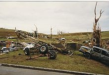
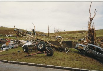
 Tornado damage near Leota, Minnesota
On Tuesday, June 16, 1992, eastern South Dakota and southwest Minnesota were heavily impacted by the storm as it moved from the Rocky Mountain Region across the Upper Midwest. At least two dozen tornadoes were reported that day, with more than three times that many reports of large hail and strong winds, causing widespread swaths of damage to crops, buildings, and other personal property across much of eastern South Dakota and southwest Minnesota. The first tornado, spawned by a supercell thunderstorm, touched down in Charles Mix County, South Dakota about 1:00 pm. The last tornado was reported shortly before midnight that evening, ending an 11 hour period of intense severe weather across eastern South Dakota and southwest Minnesota. The 27 tornadoes that touched down in Minnesota on June 16 marks the largest single day tornado outbreak in Minnesota since accurate records started being kept in 1950. [1]
Remarkably there was only one fatality from this outbreak, that coming from an F5 tornado in Chandler, Minnesota. In addition to the F5, three F4 tornadoes were reported in Murray County, Minnesota, and Mitchell and McPherson counties in Kansas. Damage estimates for the two days were in excess of $160 million dollars.[2][3][4][5]
This outbreak played a large part in a record setting month in June, 1992. The 399 tornadoes that touched down in that month was a United States record at the time, breaking the old record of 335 tornadoes set in May, 1991. This record was eventually broken, when 543 tornadoes touched down during May, 2003.[6]
Chandler – Lake Wilson tornado
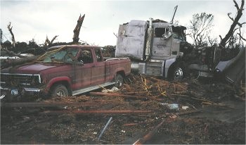
 F5 tornado damage in Chandler, Minnesota.
A tornado touched down shortly after 5:00 pm in extreme northwest Nobles County, near Leota. It destroyed a two-house farmstead just east of Leota as it strengthened and moved northeast toward Chandler and Lake Wilson. The "maxi-tornado" reached its greatest size and strength as it came over the hill immediately south of Chandler, moving into the residential area of west Chandler at approximately 5:18 pm.[4]
The tornado destroyed more than 75 homes with another 90 homes, 10 businesses, a church and school damaged. It caused over $50 million in property damage, causing one fatality and more than 40 injuries. Based on damage assessment by the National Weather Service, it is estimated this F5 tornado contained winds in excess of 260 miles per hour (418 km/h) as it moved through the residential area of Chandler. The twister was on the ground for over an hour, traveling approximately 35 miles (56 km) across southwest Minnesota, from northwest Nobles County, through Murray County, and into southeast Lyon County. It had a maximum width of .75 miles (1.21 km) in the Chandler-Lake Wilson area. This was the only F5 tornado to occur in the United States in 1992.[4]
Non-tornadic events
In addition to the severe weather, another devastating weather event was taking place across northeastern South Dakota. Heavy rains were occurring in an area already saturated by previous rains. Over a two to three day period in mid-June 1992, 15 to 20 inches of rain fell in the Clear Lake-Watertown area of northeast South Dakota, resulting in widespread flooding throughout the area, and major downstream flooding of the Big Sioux River.
A brief description of that day from two meteorology students
On June 16th, two students from the St. Cloud State meteorology department, sensing that the environment was ripe for tornadoes, and against the advice of their professors, sought to photograph, document, and experience tornadic supercells firsthand, having reviewed guidance several days in advance. Their target area was southeast South Dakota, but at approximately 330 pm, they entered the northeast periphery of a supercell, eventually running into large hail, still in southwest Minnesota. Without any modern communications (cellular phone or Internet), they decided to backtrack to Boyd, Minnesota. The Clarkfield F3 tornado passed just south of their position. They sought shelter at one of the few brick (assumed at that time to be more resistant of tornado impacts) building in the town, the municipal liquor store. When power failed, a sheriff's deputy who was dispatched there, asked for guidance from the meteorology students. The advice was that they should all seek shelter in the cooler, which was the most central spot in the building, until the tornado passed. Luckily, the tornado passed south of Boyd, although baseball sized hail did occur. (as told by one of the students on this "storm chase", although the term had not yet been coined).[citation needed]
Tornado table
Confirmed
TotalConfirmed
F0Confirmed
F1Confirmed
F2Confirmed
F3Confirmed
F4Confirmed
F5170 54 64 33 15 3 1 June 14
List of confirmed tornadoes F# Location County Time (UTC) Path length Damage Idaho F0 E of Burley Cassia 2202 0 miles Colorado F0 W of Gill Weld 0026 1 miles (1.6 km) F0 N of Goodrich Morgan 0027 0 miles F0 SE of Raymer Morgan 0027 0 miles F0 NE of Barnesville Weld 0115 0 miles F0 N of Fort Morgan Weld 0130 0 miles June 15 event
List of confirmed tornadoes F# Location County Time (UTC) Path length Damage Kansas F0 NE of Plainville (1st tornado) Rooks 2115 1 miles (1.6 km) F1 N of Natoma (1st tornado) Osborne 2126 1 miles (1.6 km) F0 E of Zurich Rooks 2128 1 miles (1.6 km) F1 NE of Plainville (2nd tornado Rooks 2137 7 miles (11.2 km) F0 N of Natona (2nd tornado) Osborne 2146 0.5 miles (0.8 km) F0 SE of Bloomington (1st tornado) Osborne 2251 0.5 miles (0.8 km) F1 SE of Bloomington (2nd tornado) Osborne 2251 2 miles (3.2 km) F1 SE of Osborne (1st tornado) Osborne 2315 0.8 miles (1.3 km) F1 SW of Osborne Osborne 2334 1 miles (1.6 km) F1 S of Osborne Osborne 2340 1 miles (1.6 km) F1 Osborne area Osborne 2345 0.5 miles (0.8 km) F1 SE of Osborne (2nd tornado) Osborne 2355 1 miles (1.6 km) F2 SE of Corinth Mitchell 2356 3.5 miles (5.6 km) F1 SE of Mankato Jewell 2359 1 miles (1.6 km) F2 NE of Tipton (1st tornado) Mitchell 0002 3 miles (4.8 km) F1 SW of Webber Jewell 0006 2 miles (3.2 km) F1 NE of Tipton (2nd tornado) Mitchell 0007 1.5 miles (2.4 km) F2 E of Mankato Jewell 0009 1.5 miles (2.4 km) F2 E of Tipton Mitchell 0010 4 miles (6.4 km) F4 SW of Beloit (1st tornado) Mitchell 0030 3 miles (4.8 km) F1 NW of Lovewell Jewell 0035 1.5 miles (2.4 km) F2 SW of Beloit (2nd tornado) Mitchell 0035 2 miles (3.2 km) F2 SW of Beloit (3rd tornado) Mitchell 0038 2 miles (3.2 km) F1 SW of Beloit (4th tornado) Mitchell 0040 2 miles (3.2 km) F3 SW of Beloit (5th tornado) Mitchell 0045 2 miles (3.2 km) F1 SW of Beloit (6th tornado) Mitchell 0055 1.5 miles (2.4 km) F0 N of Republic Republic 0100 0.5 miles (0.8 km) F1 SW of Beloit (7th tornado) Mitchell 0105 1.3 miles (2.1 km) F1 SW of Simpson Mitchell 0135 2 miles (3.2 km) F1 SE of Simpson Cloud 0152 2 miles (3.2 km) F1 NE of Simpson Cloud 0158 2 miles (3.2 km) F1 S of Delphos Ottawa 0235 1 miles (1.6 km) F3 W of Delphos Ottawa 0252 3 miles (4.8 km) F4 McPherson area McPherson 0335 6 miles (9.6 km) F1 NW of Miltonvale Cloud 0337 1 miles (1.6 km) F2 Roxbury area McPherson 0340 7 miles (11.2 km) F1 SE of Roxbury to NW of Ramona McPherson, Marion 0509 17 miles (27.2 km) F1 SW of Elmo Dickinson 0520 2 miles (3.2 km) F0 SW of Abilene Dickinson 0538 0.1 miles (0.16 km) F1 E of Enterprise Dickinson 0648 1 miles (1.6 km) F0 S of Solomon Dickinson 0705 1.5 miles (2.4 km) South Dakota F2 S of Philip Haakon 2210 2 miles (3.2 km) F0 NE of Raymond Clark 0005 0.2 miles (0.32 km) F0 SE of Bristol Day 0250 0.5 miles (0.8 km) Nebraska F1 Doniphan area Hall 0020 0.1 miles (0.16 km) F2 SW of Osceola Polk 0045 2 miles (3.2 km) F2 N of Hampton Hamilton 0055 0.1 miles (0.16 km) F0 N of Schuyler (1st tornado) Colfax 0115 0.1 miles (0.16 km) F2 N of Schuyler (2nd tornado) Colfax 0115 0.1 miles (0.16 km) F3 SE of Milligan to W of Milford Saline, Seward 0155 21 miles (33.6 km) F1 W of West Point Cuming 0250 0.5 miles (0.8 km) F1 SW of West Point Cuming 0255 0.5 miles (0.8 km) F1 SE of West Point Cuming 0300 4 miles (6.4 km) F3 W of Malcolm Seward 0315 14 miles (22.4 km) F1 N of Bancroft Cuming 0320 0.5 miles (0.8 km) F1 NW of Tecumseh Johnson 0458 1.5 miles (2.4 km) F1 NW of Johnson Johnson 0512 1.2 miles (1.9 km) F1 SW of Burr Otoe 0530 1.5 miles (2.4 km) Sources: June 16 event
List of confirmed tornadoes F# Location County Time (UTC) Path length Damage South Dakota F2 W of Mitchell (1st tornado) Davison 1930 3 miles (4.8 km) F2 W of Mitchell (2nd tornado) Davison 1930 3 miles (4.8 km) F0 NE of Letcher Sanborn 2023 0.1 miles (0.16 km) F2 SW of Fedora Miner 2025 0.5 miles (0.8 km) F3 SW of Oldham Miner 2045 3 miles (4.8 km) F3 S of Arlington Kingsbury, Brookings 2135 4 miles (6.4 km) F0 W of Oldham Kingsbury 2137 0.1 miles (0.16 km) F3 W of Fort Thompson Buffalo 2215 2 miles (3.2 km) F0 SW of Pickstown Charles Mix 0003 0.3 miles (0.5 km) F0 NE of Tripp Hutchinson 0110 0.3 miles (0.5 km) F1 Bridgewater area (1st tornado) McCook 0130 0.5 miles (0.8 km) F1 Bridgewater area (2nd tornado) McCook 0130 0.5 miles (0.8 km) F1 Brookings area Brookings 0130 7 miles (11.2 km) F1 NE of Rutland Lake 0145 1 miles (1.6 km) F0 SW of Centerville Clay 0150 0.5 miles (0.8 km) F2 Colton area Minnehaha 0200 5 miles (8 km) Iowa F1 NE of Cedar Falls Black Hawk 2003 4.7 miles (7.5 km) F3 NW of Logan to N of Dow City Harrison, Crawford 0230 26 miles (41.6 km) F0 SE of Perkins Sioux 0255 0.2 miles (0.32 km) F0 S of Ida Grove Ida 0348 0.1 miles (0.16 km) F0 NE of Soldier Monona 0401 0.1 miles (0.16 km) F2 NE of Oakland Pottawattamie 0500 4 miles (6.4 km) F2 SW of Dumfries Mills 0514 3 miles (4.8 km) F0 Harlan area Shelby 0545 0.2 miles (0.32 km) Nebraska F0 SW of Hemingford Box Butte 2120 0.1 miles (0.16 km) F0 W of Alliance Box Butte 2151 0.1 miles (0.16 km) F1 SE of Ainsworth Brown 2215 4 miles (6.4 km) F1 N of Newport Rock 2315 1 miles (1.6 km) F1 SW of Anselmo Custer 2317 0.5 miles (0.8 km) F0 SE of Anselmo Custer 2323 0.2 miles (0.32 km) F1 NW of Gates Custer 2335 0.4 miles (0.6 km) F1 SE of Naper Boyd 2338 1.5 miles (2.4 km) F1 NE of Butte Boyd 2350 10 miles (16 km) F1 Hartington area Cedar 0147 0.1 miles (0.16 km) F2 NE of Oakland Burt 0400 4 miles (6.4 km) F0 S of Western Saline 0405 0.1 miles (0.16 km) F0 NE of Waverly Lancaster 0423 0.1 miles (0.16 km) Minnesota F5 S of Leota to E of Lake Wilson Nobles, Murray 2200 16 miles (25.6 km) 1 death F4 E of Lake Wilson Murray 2218 7 miles (11.2 km) F3 S of Clarkfield Yellow Medicine 2230 6 miles (9.6 km) F2 NE of Hadley Murray 2230 13 miles (20.8 km) F3 NW of Currie Murray, Lyon 2300 12 miles (19.2 km) F2 E of Amiret Lyon 2318 2 miles (3.2 km) F3 NE of Tracy Redwood 2325 16 miles (25.6 km) F1 SW of Milroy Redwood 2355 0.1 miles (0.16 km) F2 NE of Danvers Swift 2358 1.5 miles (2.4 km) F3 W of Wabasso Redwood 0010 13 miles (20.8 km) F2 N of Vesta Redwood 0025 12 miles (19.2 km) F2 S of Delhi Redwood 0025 8 miles (12.8 km) F1 W of Redwood Falls Redwood 0030 6.5 miles (10.4 km) F2 E of Delhi Redwood 0040 5.5 miles (8.8 km) F2 W of Bechyn Renville 0050 5 miles (8 km) F2 NW of Bechyn Renville 0125 3 miles (4.8 km) F2 W of Sacred Heart Renville 0200 2.5 miles (4 km) F1 NW of Jasper Pipestone 0200 0.5 miles (0.8 km) F2 S of Chandler Murray 0210 4 miles (6.4 km) F2 W of Slayton Murray 0220 0.5 miles (0.8 km) F3 SE of Clarkfield Yellow Medicine 0240 2.5 miles (4 km) F2 S of Danube Renville 0330 2 miles (3.2 km) F2 E of Westbrook Cottonwood 0330 7.5 miles (12 km) F1 SE of Leavenworth Brown 0400 1 miles (1.6 km) F3 Cokato area Wright 0410 10 miles (16 km) F2 N of Maple Lake Wright 0420 10 miles (16 km) F2 NW of Foley Benton 0450 0.3 miles (0.5 km) North Dakota F0 E of Bismarck Burleigh 2320 0.1 miles (0.16 km) Sources: See also
- List of Minnesota weather records
- List of North American tornadoes and tornado outbreaks
- List of SPC High Risk days
References
- ^ "Minnesota Tornado History and Statistics". Minnesota Climatology Office. 2006-09-20. http://climate.umn.edu/doc/historical/tornadic.htm. Retrieved 2007-03-09.
- ^ "JUNE IN THE CENTRAL AND SOUTHERN PLAINS STATES". Intellicast.com. http://www.intellicast.com/Almanac/SouthCentral/June. Retrieved 2007-03-09.
- ^ Woelm, Scott. "Top 10 Minnesota Severe Weather Events 1990-1999". Minnesota Skywarn. http://www.skywarn.ampr.org/mn_top10.html. Retrieved 2007-03-09.
- ^ a b c "Chandler-Lake Wilson Minnesota F5 Tornado". National Weather Service - Sioux Falls. http://www.crh.noaa.gov/fsd/storms/chandler/index.php. Retrieved 2007-03-09.
- ^ "Storm Events". National Climatic Data Center. http://www4.ncdc.noaa.gov/cgi-win/wwcgi.dll?wwevent~storms. Retrieved 2007-03-09.
- ^ http://www.spc.noaa.gov/faq/tornado/may2003.htm
Categories:- F5 tornadoes
- Tornadoes of 1992
- Tornadoes in Iowa
- Tornadoes in Kansas
- Tornadoes in Minnesota
- Tornadoes in Nebraska
- Tornadoes in South Dakota
- 1992 in the United States

Wikimedia Foundation. 2010.