- Clarkfield, Minnesota
-
Clarkfield, Minnesota — City — Aerial view of Clarkfield from the southwest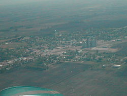 Location of Clarkfield, Minnesota
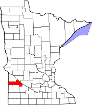
Coordinates: 44°47′28″N 95°48′12″W / 44.79111°N 95.80333°W Country United States State Minnesota County Yellow Medicine Government – Mayor Gene Kockelman Area – Total 1.1 sq mi (2.8 km2) – Land 1.1 sq mi (2.8 km2) – Water 0.0 sq mi (0.0 km2) Elevation 1,089 ft (332 m) Population (2010)[1] – Total 863 Time zone Central (CST) (UTC-6) – Summer (DST) CDT (UTC-5) ZIP code 56223 Area code(s) 320 FIPS code 27-11656[2] GNIS feature ID 0641251[3] Website www.clarkfieldminnesota.com Clarkfield is a city in Yellow Medicine County, Minnesota, United States, surrounded by Friendship Township. The population was 863 at the 2010 census.[1]
Contents
Geography
According to the United States Census Bureau, the city has a total area of 1.1 square miles (2.8 km2), all of it land.
U.S. Route 59 and Minnesota State Highway 67 are two of the main routes in the city.
Government
The mayor of Clarkfield is Gene Kockelman. The city council includes Steve Hubbard, Francis Staab, Bob Schlenner, and Dave Biermaier.
Demographics
As of the census[2] of 2000, there were 944 people, 371 households, and 228 families residing in the city. The population density was 872.7 people per square mile (337.5/km²). There were 429 housing units at an average density of 396.6 per square mile (153.4/km²). The racial makeup of the city was 98.52% White, 0.11% African American, 0.21% Native American, 0.11% Asian, 0.42% from other races, and 0.64% from two or more races. Hispanic or Latino of any race were 1.17% of the population.
There were 371 households out of which 26.1% had children under the age of 18 living with them, 50.9% were married couples living together, 8.4% had a female householder with no husband present, and 38.5% were non-families. 35.3% of all households were made up of individuals and 22.1% had someone living alone who was 65 years of age or older. The average household size was 2.25 and the average family size was 2.92.
In the city the population was spread out with 21.7% under the age of 18, 7.1% from 18 to 24, 20.9% from 25 to 44, 19.0% from 45 to 64, and 31.4% who were 65 years of age or older. The median age was 45 years. For every 100 females there were 89.2 males. For every 100 females age 18 and over, there were 84.3 males.
The median income for a household in the city was $33,819, and the median income for a family was $39,926. Males had a median income of $28,900 versus $17,431 for females. The per capita income for the city was $17,349. About 10.1% of families and 12.8% of the population were below the poverty line, including 17.2% of those under age 18 and 14.4% of those age 65 or over.
References
- ^ a b "2010 Census Redistricting Data (Public Law 94-171) Summary File". American FactFinder. United States Census Bureau. http://factfinder2.census.gov/faces/tableservices/jsf/pages/productview.xhtml?pid=DEC_10_PL_GCTPL2.ST13&prodType=table. Retrieved 27 April 2011.
- ^ a b "American FactFinder". United States Census Bureau. http://factfinder.census.gov. Retrieved 2008-01-31.
- ^ "US Board on Geographic Names". United States Geological Survey. 2007-10-25. http://geonames.usgs.gov. Retrieved 2008-01-31.
External links
Municipalities and communities of Yellow Medicine County, Minnesota Cities Canby | Clarkfield | Echo | Granite Falls‡ | Hanley Falls | Hazel Run | Porter | St. Leo | Wood Lake
Townships Indian
reservationFootnotes ‡This populated place also has portions in an adjacent county or counties
Coordinates: 44°47′26″N 95°48′31″W / 44.79056°N 95.80861°W
Categories:- Cities in Minnesota
- Populated places in Yellow Medicine County, Minnesota


Wikimedia Foundation. 2010.