- Early-May 2010 tornado outbreak
-
May 2010 Oklahoma tornado outbreak A tornado near the Harper & Kingman county line in Kansas on May 10, 2010. The tornado was rated EF2.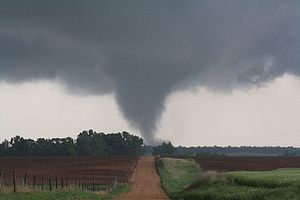
Date of tornado outbreak: May 10–13, 2010 Duration1: ~3 days, 12 hours Maximum rated tornado2: EF4 tornado Tornadoes caused: 91 confirmed Damages: >$595 million[1] Fatalities: 3 [2] Areas affected: Oklahoma, Kansas, Missouri 1Time from first tornado to last tornado
2Most severe tornado damage; see Enhanced Fujita ScaleThe May 2010 tornado outbreak was a major tornado outbreak that occurred on May 10, 2010 affecting large areas of Oklahoma, Kansas, and Missouri, with the bulk of the activity in central and eastern Oklahoma. Over 60 tornadoes, some large and multiple-vortex in nature, affected large parts of Oklahoma and adjacent parts of southern Kansas and Missouri, with the most destructive tornadoes causing severe damage in southern suburbs of the Oklahoma City metropolitan area and just east of Norman, Oklahoma, where the fatalities were reported from both tornado tracks. The outbreak was responsible for three fatalities, both of which occurred in Oklahoma including a 41-year-old man in Oklahoma City and a 27-year-old woman near Norman.[3] Damage was estimated to be over $595 million in central Oklahoma alone.[1]
Tornado activity continued to a lesser extent until May 13, with a few tornadoes occurring across parts of Oklahoma, Kansas, Missouri and Texas, caused by disturbances connected to the storm system that produced the earlier outbreak.
Contents
Meteorological synopsis
An intense trough with dry line activity moved across the southern Plains, especially Oklahoma and southern Kansas, on May 10. For the fourth time in less than three weeks, a high risk of severe weather was issued by the Storm Prediction Center; the high risk covered portions of Oklahoma and Kansas from the interchange of I-35, I-40 and I-44 in the Oklahoma City area, northeastward into southeastern Kansas and eastern Oklahoma ;[4] these areas were in the warm sector. Temperatures in the upper 70s to mid 80s°F (upper 20s °C), dewpoints in the upper 60s °F (near 20 °C), very strong deep layer wind shear aided by a strong 500mb jet streak and mixed-layer CAPE values well in excess of 3000 J/kg,[5][6] aided in highly unstable conditions capable of explosive thunderstorm development and the likelihood of strong, long-track tornadoes with any severe thunderstorms.
Two "particularly dangerous situation" tornado watches were issued that day covering the majority of Oklahoma and portions of Arkansas, Kansas and Missouri.[7][8] Strong jet stream winds above the surface permitted storm cell motions of more than 40 miles per hour (64 km/h) in many of the storms, creating even more of a dangerous situation for residents in the path of the storms as it aided in any tornadoes that touched down to track several miles in a relatively short period of time. Supercell thunderstorms erupted in the early and mid-afternoon hours in southern Kansas and northern and central Oklahoma. One supercell in northern Oklahoma produced large, multiple-vortex tornadoes that caused significant damage in Medford, Oklahoma.[9] The National Weather Service forecast office in Norman issued the first severe thunderstorm warning of the outbreak for this particular storm at 2:11 p.m. CDT,[10] which was quickly upgraded to a tornado warning 11 minutes later at 2:22 p.m. CDT.[11] Hail was measured as large as 4-6 inches (10-15 cm) in diameter in Oklahoma and Kansas.[12]
Later in the afternoon, another tornado touched down near Yukon, Oklahoma in the western part of the Oklahoma City metropolitan area, followed by numerous others in the area with a trailer park flattened near Norman, Oklahoma according to KWTV coverage with at least one fatality and many injuries reported. Within a time span of three hours from about 3:30 to 6:30 p.m. CDT (2030 to 2330 UTC), coinciding with the afternoon rush hour, a total of 39 tornadoes touched down (including most of the strongest tornadoes), with 21 tornadoes touching down in a single hour between 5:00 and 6:00 p.m. CDT at the peak of the outbreak. During that hour, there were periods that several tornadoes were on the ground simultaneously. A large grocery store along Highway 9 east of Norman and Lake Thunderbird was severely damaged by a large tornado. Early that evening, a long-lived supercell tracked parallel to Interstate 40 and produced several large and destructive tornadoes from the Oklahoma City metro area through eastern Oklahoma to nearly the Arkansas state line, finally lifting for the last time just before 9:00 p.m. CDT (0200 UTC). Initially, three people were reported to have been killed in Tecumseh, however emergency management officials later advised that there were no fatalities in Tecumseh. Due to the fast movement of the storms, the National Weather Service had, at a couple of points during the outbreak, issued severe thunderstorm and tornado warning polygons encompassing several counties, including one tornado warning that included the entire Oklahoma City metropolitan area and neighboring suburbs in Grady, Canadian and Cleveland counties.[11]
The Oklahoma Department of Emergency Management reported that 103 homes were destroyed and that 70 homes had major damage from the storm. In addition, 43 businesses were destroyed, 13 barns were destroyed or damaged, and 69 homes had minor damage.[13] The Oklahoma City Emergency Management's assessment determined that 72 dwellings or businesses were destroyed, 483 were damaged and 226 were affected in some way.[14] The Oklahoma State Department of Health reported that 104 people were treated for injuries. A state of emergency was declared for 56 counties in Oklahoma.[3]
The surface front associated with the storm system that resulted in the May 10th outbreak stalled across the Southern Plains, and a series of smaller disturbances contributed to additional severe weather on May 12 and 13. Eight tornadoes occurred in Kansas, Oklahoma and Texas on May 12, though no significant damage resulted. Later that evening, the earlier activity formed into a mesoscale convective complex, and produced 11 tornadoes as the complex pushed into parts of southern Kansas, southwestern Missouri and northeastern Oklahoma; many of which developed without advance warning.
Moore-Choctaw tornado
At 5:20 p.m. CDT (2220 UTC), a tornado touched down in the southern part of Moore, Oklahoma in Cleveland County near the interchange of Interstate 35 and Indian Hills Road (exit 114) and quickly turned to the east-northeast. Initially, the damage was mostly limited to trees as it tracked across mostly undeveloped land in southeast Moore and extreme southeast Oklahoma City near Stanley Draper Lake, with a few houses sustaining minor damage. Damage increased substantially when it reached near the intersection of SE 89th Street and Hiawassee Road as it turned north-northeast through the semi-rural areas of eastern Oklahoma County.[15]
As it approached Interstate 40, severe damage was done to several businesses at Choctaw Road (exit 166), including a Love's Travel Stop which was destroyed and a Sonic Drive-In which was heavily damaged; employees and several motorists took shelter inside the Love's Travel Stop, they were not hurt. Two people were killed by the tornado and 49 others were injured, including many motorists in afternoon rush hour traffic on I-40 who had their cars thrown. Numerous other houses were heavily damaged or destroyed, with a few flattened, as the tornado tracked across residential subdivisions near Choctaw and Harrah. The most severe damage was in the Deerfield West subdivision. The tornado lifted in Harrah, just northeast of Reno and Harrah Road, after being on the ground for 24 miles (38 km).[15]
Initially, the tornado was rated as an EF3. However, due to additional damage surveys finding houses flattened in subdivisions that were difficult to access due to damage, it was upgraded to an EF4.[16]
Norman-Little Axe tornado
Another intense tornado developed in the southern part of Norman in Cleveland County, very close to the National Weather Center at 5:32 p.m. CDT (2232 UTC), and initially precipitated EF1 damage to some homes and businesses, breaking windows and doors, partially stripping some roofs, and destroying well built wood fences. The tornado gradually intensified as it tracked eastward through the southeastern part of Norman towards Lake Thunderbird. The tornado crossed Lake Thunderbird, severely damaging a marina with about 300 boats in total damaged.[15] Footage from NBC affiliate KFOR-TV's news helicopter captured footage of a van belonging to a plumbing repair company being tossed by the tornado, the man driving the van was uninjured.[17]
The tornado then hit Little Axe Public Schools with significant damage on that property, with concrete pillars and metal bleachers thrown considerable distances. A large grocery store near Little Axe was severely damaged, its roof completely collapsed, and only a few sections of its walls remained standing. Severe damage was reported in several subdivisions in and east of Little Axe, with numerous houses destroyed or completely flattened and trees were stripped of their bark and branches as it crossed into Pottawatomie County near the community of Pink. The tornado weakened after crossing the county line and lifted between Pink and Tecumseh just before 6:00 pm CDT after being on the ground for about 22 miles (35 km). A 27-year-old woman was killed by this tornado and her three children, initially reported as having been killed as well, were seriously injured.[15] In total, 32 people were injured.
Like the Moore-Choctaw tornado, this was initially rated as an EF3. However, it was upgraded to EF4 in subsequent surveys after additional damage assessments found flattened houses on the eastern end of the track.[16]
Tornadoes
Confirmed
TotalConfirmed
EF0Confirmed
EF1Confirmed
EF2Confirmed
EF3Confirmed
EF4Confirmed
EF591 39 33 13 4 2 0 May 10 event
List of reported tornadoes - Monday, May 10, 2010 EF# Location County Coord. Time (UTC) Path length Comments/Damage Kansas EF1 NE of Marienthal Wichita 38°29′N 101°11′W / 38.48°N 101.19°W 1827 1 mile (1.6 km) A small shed was destroyed. EF0 NNE of Marienthal Wichita 38°33′N 101°11′W / 38.55°N 101.19°W 1831 1 mile (1.6 km) Tornado remained over open country with no damage. EF0 SSW of Russell Springs Logan 38°49′N 101°13′W / 38.82°N 101.22°W 1850 2 miles (3.2 km) Tornado remained over open country with no damage. EF0 S of Russell Springs Logan 38°48′N 101°07′W / 38.80°N 101.12°W 1918 2 miles (3.2 km) Tornado remained over open country with no damage. EF0 W of Elkader Logan 38°46′N 101°02′W / 38.77°N 101.04°W 1922 1 mile (1.6 km) Tornado remained over open country with no damage. EF0 SW of Zenda Kingman 38°24′N 101°19′W / 38.40°N 101.31°W 2112 3 miles (4.8 km) Rope tornado remained over open country with no damage. EF2 SE of Belmont Kingman 37°30′N 97°59′W / 37.50°N 97.98°W 2134 3 miles (4.8 km) One house sustained severe damage and several others sustained lesser damage. EF1 N of Norwich Kingman 37°31′N 97°52′W / 37.52°N 97.86°W 2144 2 miles (3.2 km) Damage limited to uprooted trees. EF1 E of Arkansas City (1st tornado) Cowley 37°04′N 97°01′W / 37.06°N 97.02°W 2149 1 mile (1.6 km) A bait shop and a storage shed were damaged. EF0 N of Viola Sedgwick 37°36′N 97°38′W / 37.60°N 97.64°W 2158 5 miles (8.0 km) Tornado confirmed by spotters, remained on the ground near Wichita Mid-Continent Airport. At least one house was damaged. EF1 E of Arkansas City (2nd tornado) Cowley 37°06′N 96°58′W / 37.10°N 96.96°W 2208 1 mile (1.6 km) Two houses were damaged and outbuildings were destroyed. Initially believed to be one tornado but confirmed as two separate touchdowns. EF0 SW of Grenola Elk 37°19′N 96°30′W / 37.31°N 96.50°W 2228 unknown Brief tornado touchdown with no damage. Oklahoma EF0 SW of Wakita Grant 36°47′N 98°03′W / 36.79°N 98.05°W 2033 1 mile (1.6 km) Tornado remained in open country with no damage. EF3 N of Medford Grant, Kay, Sumner (KS) 36°52′N 97°49′W / 36.87°N 97.81°W 2043 41 miles (66 km) Long track, large wedge tornado with significant damage, including to houses of which at least one was destroyed. Tractor-trailers were flipped on Interstate 35 at the Kansas-Oklahoma state line. Two people were injured. EF0 NW of Medford Grant 36°50′N 97°46′W / 36.83°N 97.76°W 2103 unknown Brief satellite tornado to the main Medford wedge with no damage. EF1 NW of Braman Grant, Kay 36°55′N 97°29′W / 36.92°N 97.49°W 2115 5 miles (8.0 km) Numerous trees and power poles were snapped. EF1 N of Braman Kay 36°58′N 97°26′W / 36.96°N 97.43°W 2117 7 miles (11 km) One house sustained significant roof damage and two tractor-trailers were blown off Interstate 35 south of the Kansas state line. EF0 N of Nardin Kay 36°54′N 97°26′W / 36.90°N 97.44°W 2121 1 mile (1.6 km) Anticyclonic tornado damaged a few trees and power poles. EF0 Cashion area Canadian, Kingfisher, Logan 35°43′N 97°45′W / 35.72°N 97.75°W 2146 7 miles (11 km) Numerous outbuildings, trees and power poles were damaged. EF0 NE of Union City Canadian 35°26′N 97°53′W / 35.43°N 97.89°W 2146 4 miles (6.4 km) Tornado confirmed by KWTV coverage with no damage. EF0 NE of Red Rock Noble 36°28′N 97°09′W / 36.47°N 97.15°W 2153 1 mile (1.6 km) Brief tornado touchdown with no damage. EF1 E of Marland Noble, Osage 36°32′N 97°03′W / 36.53°N 97.05°W 2200 21 miles (34 km) Very large wedge tornado which was 1.4 miles (2.2 km) wide damaged several houses and destroyed several barns and outbuildings. EF1 SE of Marland Noble 36°30′N 97°04′W / 36.50°N 97.07°W 2202 2 miles (3.2 km) A house and a casino sustained minor damage. EF1 Hastings Jefferson 34°13′N 98°05′W / 34.22°N 98.09°W 2205 5 miles (8.0 km) One house sustained severe damage as the tornado tracked onto Waurika Lake. EF0 N of The Village Oklahoma 35°36′N 97°32′W / 35.60°N 97.53°W 2213 unknown Brief tornado spotted near Quail Springs Mall by an Oklahoma City Police Department officer with no damage. EF1 NE of Bray Stephens, Grady 34°39′N 97°46′W / 34.65°N 97.76°W 2220 7 miles (11 km) A few mobile homes sustained minor damage. Many trees, fences and power poles were also damaged. Tornado rotated in an anti-cyclonic direction, reverse from most tornadoes. EF4 Moore area (1st tornado) Cleveland, Oklahoma 35°19′N 97°31′W / 35.32°N 97.51°W 2220 24 miles (39 km) 2 deaths - See section on this tornado EF1 Moore area (2nd tornado) Cleveland 35°21′N 97°26′W / 35.35°N 97.44°W 2222 4 miles (6.4 km) Satellite tornado to the main Moore tornado. A few houses were damaged in the suburban area. EF1 Moore area (3rd tornado) Cleveland 35°18′N 97°25′W / 35.30°N 97.41°W 2227 1 mile (1.6 km) Second satellite tornado to the main Moore tornado. A few houses and a restaurant sustained roof damage. EF4 Norman area (1st tornado) Cleveland, Pottawatomie 35°12′N 97°25′W / 35.20°N 97.42°W 2232 22 miles (35 km) 1 death - See section on this tornado EF0 E of Burbank (1st tornado) Osage 36°42′N 96°36′W / 36.70°N 96.60°W 2233 unknown Brief tornado touchdown with no damage. EF1 Norman area (2nd tornado) Cleveland 35°11′N 97°23′W / 35.18°N 97.39°W 2234 6 miles (9.7 km) Parallel track and possible satellite to the main Norman tornado. Minor damage to houses and trees from this anticyclonic tornado. EF1 W of Wayne (1st tornado) McClain 34°53′N 97°25′W / 34.88°N 97.41°W 2236 4.6 miles (7.4 km) The Mid-America Technology Center sustained significant damage from this large anti-cyclonic tornado. EF0 W of Wayne (2nd tornado) McClain 34°53′N 97°25′W / 34.89°N 97.42°W 2237 0.75 miles (1.21 km) Satellite tornado to the 1st Wayne tornado, rotated in the normal direction. A shed was damaged by this brief spin-up tornado. EF2 Norman area (3rd tornado) Cleveland, Pottawatomie 35°07′N 97°14′W / 35.12°N 97.23°W 2239 17 miles (27 km) Severe damage in a mobile home park with many mobile homes destroyed. A cell phone tower was mangled and the Country Boy IGA grocery store was heavily damaged. Extensive tree damage also took place. Three people were injured. Tornado generally followed the 1st Norman tornado. EF0 E of Burbank (2nd tornado) Osage 36°44′N 96°34′W / 36.74°N 96.56°W 2241 1 mile (1.6 km) Tornado remained over open country with no damage. EF0 WSW of Cornish Jefferson 34°06′N 97°44′W / 34.10°N 97.74°W 2244 2 miles (3.2 km) Tornado remained over pastures with no damage. EF0 NW of Pawhuska Osage 36°41′N 96°20′W / 36.69°N 96.34°W 2245 1 mile (1.6 km) Tornado remained over open country with no damage. EF3 N of Pink Pottawatomie 35°20′N 97°05′W / 35.34°N 97.09°W 2248 7 miles (11 km) Several houses were destroyed except for interior walls standing and metal poles attached to poles were ripped from the ground. Trees were also debarked. Three people were injured. EF0 E of Loco Stephens 34°19′N 97°38′W / 34.32°N 97.63°W 2250 2 miles (3.2 km) Tornado remained over open country with no damage. EF3 Tecumseh to Bearden Pottawatomie, Seminole, Okfuskee 35°14′N 96°48′W / 35.23°N 96.80°W 2256 37 miles (60 km) Large and intense tornado confirmed by the VORTEX2 team which was 1.25 miles (2 km) wide. Severe damage to many houses reported. The Seminole County Airport was also destroyed and many trees were debarked. 31 people were injured, some seriously. EF2 NW of Wilson Carter 34°10′N 97°29′W / 34.17°N 97.49°W 2304 5 miles (8.0 km) Several mobile homes were destroyed and many trees were heavily damaged. EF3 N of Lone Grove Carter 34°13′N 97°18′W / 34.22°N 97.30°W 2322 4.9 miles (7.9 km) One house and four mobile homes were destroyed and numerous other houses were damaged. Extensive tree and power line damage, including to high tension poles. EF0 E of Lone Grove Carter 34°11′N 97°12′W / 34.19°N 97.20°W 2325 1 mile (1.6 km) Tornado confirmed by videotape with no damage. EF1 SE of Okemah Okfuskee 35°20′N 96°17′W / 35.34°N 96.29°W 2345 14 miles (23 km) Several houses were damaged and several outbuildings were destroyed. Damage also reported to trees and power lines. EF0 E of Lexington Cleveland 35°01′N 97°11′W / 35.02°N 97.19°W 2352 2 miles (3.2 km) Damage limited to trees along the path. EF1 ENE of Marietta Love 33°57′N 97°02′W / 33.95°N 97.03°W 2354 2 miles (3.2 km) A country store and several outbuildings were damaged, and many trees were snapped or uprooted. EF0 NE of Bryant Okmulgee 35°24′N 96°03′W / 35.40°N 96.05°W 0003 0.5 miles (800 m) Brief tornado slightly damaged one house and a few trees. EF2 S of Henryetta Okmulgee 35°25′N 95°58′W / 35.42°N 95.96°W 0004 12 miles (19 km) Large wedge tornado reported on the ground in the area. A boat dock on Henryetta Lake was destroyed, along with a mobile home and an outbuilding. Several other houses and mobile homes were damaged and a large swath of trees were damaged. EF0 SE of Lebanon Marshall 33°57′N 96°53′W / 33.95°N 96.88°W 0008 1 mile (1.6 km) Tornado confirmed by spotters with no damage. EF0 NW of Willis Marshall 33°55′N 96°52′W / 33.92°N 96.87°W 0015 1 mile (1.6 km) Tornado confirmed by spotters with no damage. EF2 SE of Burney McIntosh 35°24′N 95°52′W / 35.40°N 95.87°W 0017 2 miles (3.2 km) A barn and a mobile home were destroyed. EF1 SE of Boley Okfuskee 35°30′N 96°13′W / 35.50°N 96.22°W 0018 15.5 miles (24.9 km) Houses were damaged and the roof of the local police station was torn off. Major damage to trees and power poles. EF2 S of Hitchita McIntosh 35°25′N 95°47′W / 35.42°N 95.79°W 0023 13 miles (21 km) Several houses and mobile homes were heavily damaged and barns were destroyed along and near Lake Eufaula. EF0 E of Burney McIntosh 35°25′N 95°47′W / 35.41°N 95.78°W 0025 unknown Brief tornado snapped a few tree limbs. EF1 W of Checotah McIntosh 35°26′N 95°43′W / 35.43°N 95.72°W 0028 3 miles (4.8 km) Tornado reported by KOTV reports. Numerous trees were snapped and a tractor was rolled. EF1 SW of Pierce McIntosh 35°25′N 95°43′W / 35.41°N 95.71°W 0030 1 mile (1.6 km) Trees and power poles were damaged. EF1 Pierce McIntosh 35°26′N 95°44′W / 35.43°N 95.73°W 0031 1 mile (1.6 km) Trees and power poles were damaged. EF0 NE of Pierce McIntosh 35°27′N 95°42′W / 35.45°N 95.70°W 0032 1 mile (1.6 km) Brief tornado snapped a few tree limbs. EF1 Richardsville area McIntosh 35°28′N 95°40′W / 35.46°N 95.66°W 0033 1 mile (1.6 km) Large anticyclonic tornado destroyed the local fire department building and several mobile homes and damaged a few houses. EF2 SE of Hitchita McIntosh 35°30′N 95°44′W / 35.50°N 95.73°W 0035 1 mile (1.6 km) A barn and a mobile home were destroyed and two houses were severely damaged. Trees and power poles were also damaged. EF1 SE of Rentiesville McIntosh 35°31′N 95°27′W / 35.51°N 95.45°W 0046 7 miles (11 km) A mobile home was destroyed and a house was damaged. EF1 NE of Shady Grove Muskogee 35°31′N 95°20′W / 35.52°N 95.33°W 0056 2 miles (3.2 km) A couple houses lost their roofs. Extensive damage to trees and power poles. EF0 S of Mill Creek Johnston 34°21′N 96°52′W / 34.35°N 96.86°W 0105 4 miles (6.4 km) Tornado repoted by the county EMA with no damage. EF1 N of Webbers Falls Muskogee, Sequoyah 35°34′N 95°11′W / 35.57°N 95.19°W 0106 13 miles (21 km) Large wedge tornado with significant damage in a campground where recreational vehicles were thrown near Tenkiller Lake. Several houses were also damaged. Three people were injured. EF1 S of Marble City Sequoyah 35°33′N 94°52′W / 35.55°N 94.87°W 0127 4 miles (6.4 km) Damage to trees and power poles. EF2 Coleman area Johnston, Atoka 34°15′N 96°25′W / 34.25°N 96.42°W 0142 2 miles (3.2 km) Several houses sustained major damage and others sustained lesser damage. The U Cross Arena and Pavilion was heavily damaged. Sources: SPC Storm Reports of 05/10/10, NWS Wichita, NWS Tulsa, NWS Norman, NCDC Storm Data
May 11 event
List of reported tornadoes - Tuesday, May 11, 2010 EF# Location County Coord. Time (UTC) Path length Comments/Damage Oklahoma EF0 WSW of Sharon Woodward 36°11′N 99°33′W / 36.18°N 99.55°W 0127 unknown Brief tornado touchdown with no damage. Sources: May 12 event
List of reported tornadoes - Wednesday, May 12, 2010 EF# Location County Coord. Time (UTC) Path length Comments/Damage Kansas EF0 SW of Galva McPherson 38°20′N 97°32′W / 38.33°N 97.53°W 2038 1 mile (1.6 km) Tornado remained over open country. EF0 SSW of Elyria McPherson 38°13′N 97°38′W / 38.22°N 97.64°W 2052 2 miles (3.2 km) Tornado remained over open country. EF0 WSW of Canton McPherson 38°21′N 97°28′W / 38.35°N 97.47°W 2116 1 mile (1.6 km) Tornado remained over open country. EF0 SW of Haven Reno 37°51′N 97°47′W / 37.85°N 97.78°W 2118 1 mile (1.6 km) Tornado remained over open country. EF0 NNE of Towanda McPherson 37°48′N 96°59′W / 37.80°N 96.98°W 0111 1 mile (1.6 km) Tornado remained over open pasture land. Oklahoma EF0 NW of Vinson Harmon 34°59′N 99°56′W / 34.98°N 99.94°W 2320 3 miles (4.8 km) Tornado remained over open country. EF1 NE of Bessie Washita, Custer 35°23′N 98°56′W / 35.39°N 98.94°W 0121 10 miles (16 km) A barn and a house were damaged, along with a few power poles. Missouri EF0 S of Plattsburg Clinton 39°30′N 94°28′W / 39.50°N 94.46°W 2320 unknown Brief tornado damaged two greenhouses and several trees and power lines. Sources: May 13 event
List of reported tornadoes - Thursday, May 13, 2010 EF# Location County Coord. Time (UTC) Path length Comments/Damage Oklahoma EF1 SE of Milfay Creek 36°07′N 95°55′W / 36.12°N 95.92°W 0919 20 miles (32 km) Long track, large wedge tornado damaged numerous houses and destroyed barns and outbuildings. Extensive tree and power pole damage. EF2 South Tulsa Creek, Tulsa 36°00′N 96°07′W / 36.00°N 96.11°W 0943 23 miles (37 km) Tornado started in Sapulpa and tracked across much of Tulsa south of downtown. Damage to many houses and businesses, with the most significant damage near U.S. Route 75 EF1 Glenpool area Creek, Tulsa 36°07′N 95°55′W / 36.12°N 95.92°W 0945 16 miles (26 km) Minor damage to numerous houses, businesses and trees in the mostly suburban area. EF2 SE of Okmulgee Okmulgee 35°37′N 95°53′W / 35.61°N 95.88°W 0952 6 miles (9.7 km) Two houses were heavily damaged and several others sustained minor damage. Barns and outbuildings were also destroyed. EF2 SE of Oneta Wagoner 36°01′N 95°41′W / 36.01°N 95.69°W 1004 5 miles (8.0 km) One house was severely damaged and two people were injured in that house. Sheds and outbuildings were destroyed and trees and power poles were knocked down. EF2 SW of Claremore Rogers 36°14′N 95°41′W / 36.23°N 95.69°W 1005 6 miles (9.7 km) Two houses sustained major damage, and a metal building at the Port of Catoosa was also heavily damaged. EF0 E of Catoosa Rogers 36°09′N 95°40′W / 36.15°N 95.67°W 1009 3 miles (4.8 km) A barn was damaged and trees were blown down. EF2 SE of Inola Rogers, Mayes 36°07′N 95°29′W / 36.11°N 95.49°W 1017 8 miles (13 km) A wood-frame metal shop was destroyed and several houses were heavily damaged. High-tension power poles were also knocked down. Two people were injured. EF1 E of Hulbert Cherokee 35°55′N 95°07′W / 35.92°N 95.11°W 1037 4 miles (6.4 km) Many trees were snapped and several outbuildings were damaged. EF1 E of Moodys Cherokee 36°01′N 94°53′W / 36.02°N 94.89°W 1051 4 miles (6.4 km) Damage limited to trees and limbs. EF1 S of Copeland Delaware, Ottawa 36°40′N 94°50′W / 36.66°N 94.84°W 1105 8 miles (13 km) Many trees were snapped or uprooted and several houses were damaged. Arkansas EF1 NW of Savoy Washington 36°07′N 94°21′W / 36.11°N 94.35°W 1124 unknown Brief tornado reported by KNWA coverage. Trees were uprooted and snapped. Missouri EF1 SSW of Monett Barry 36°55′N 93°56′W / 36.91°N 93.93°W 1200 2 miles (3.2 km) The tornado destroyed a casino park area in the Plymouth Hill Subdivision and a Pizza Hut restaurant. EF0 SE of Hurley Stone 36°55′N 93°26′W / 36.91°N 93.43°W 1242 0.75 miles (1.21 km) One house sustained minor damage and many trees were damaged. EF0 NE of Sparta Christian 37°01′N 93°04′W / 37.01°N 93.06°W 1300 4 miles (6.4 km) The tornado downed many trees and damaged at least one house. Sources: SPC Storm Reports of 05/13/10, NWS Tulsa, NWS Tulsa PNS, NCDC Storm Data
See also
- Tornadoes of 2010
References
- ^ a b "NCDC: Event Details". NOAA. http://www4.ncdc.noaa.gov/cgi-win/wwcgi.dll?wwevent~ShowEvent~806828. Retrieved 2010-09-20.
- ^ "Annual Fatal Tornado Summaries". NOAA. http://www.spc.noaa.gov/climo/torn/fataltorn.html. Retrieved 2010-06-17.
- ^ a b "More Power Outages Reported". KSBI. 2010-05-12. http://www.ksbitv.com/news/93609954.html. Retrieved 2010-05-13.[dead link]
- ^ "Hazardous Weather Outlook". Noaa.gov. http://forecast.weather.gov/product.php?site=NWS&issuedby=OUN&product=HWO&format=txt&version=12&glossary=0. Retrieved 22 May 2010.
- ^ Guyer, Jared (2010-05-10). "Convective Outlook: 2000 UTC May 10, 2010". Storm Prediction Center. http://www.spc.noaa.gov/products/outlook/archive/2010/day1otlk_20100510_2000.html. Retrieved 2010-05-13.
- ^ Kerr, Brynn (2010-05-10). "Mesoscale Discussion 506". Storm Prediction Center. http://www.spc.noaa.gov/products/md/md0506.html. Retrieved 2010-05-13.
- ^ Hart, John (2010-05-10). "Tornado watch 147". Storm Prediction Center. http://www.spc.noaa.gov/products/watch/ww0147.html. Retrieved 2010-05-11.
- ^ Hales, Jack (2010-05-10). "Tornado watch 150". Storm Prediction Center. http://www.spc.noaa.gov/products/watch/ww0150.html. Retrieved 2010-05-11.
- ^ Storm Prediction Center (2010-05-10). "Storm Reports". Storm Prediction Center. http://www.spc.noaa.gov/climo/reports/100422_rpts.html. Retrieved 2010-05-10.
- ^ Iowa Environmental Mesonet (2010-05-10). "Severe Thunderstorm Warning". Iowa Environmental Mesonet. http://mesonet.agron.iastate.edu/vtec/#2010-O-NEW-KOUN-SV-W-0052. Retrieved 2010-05-12.
- ^ a b Iowa Environmental Mesonet (2010-05-10). "Tornado Warning". Iowa Environmental Mesonet. http://mesonet.agron.iastate.edu/vtec/#2010-O-NEW-KOUN-TO-W-0003. Retrieved 2010-05-12.
- ^ http://www.startribune.com/blogs/93362549.html?elr=KArks7PYDiaK7DUvckD_V_jEyhD:UiD3aPc:_Yyc:aUU
- ^ "Storm death toll reduced to 2; Henry declares state of emergency". Tulsa World. 2010-05-12. http://www.tulsaworld.com/news/article.aspx?subjectid=12&articleid=20100511_298_0_hrimgs994671. Retrieved 2010-05-12.
- ^ "Oklahoma tornadoes: At least six of Monday's tornadoes classified at EF-3". The Oklahoman. 2010-05-12. http://newsok.com/oklahoma-tornadoes-at-least-six-of-mondays-tornadoes-classified-at-ef-3/article/3460770. Retrieved 2010-05-13.
- ^ a b c d National Weather Service (2010-05-11). "Public Information Statement about Tornado Damage Paths Issued at 5/12/2010 11:50 am CDT". National Weather Service, Norman OK. http://www.srh.noaa.gov/oun/?n=events-20100510-pns1. Retrieved 2010-05-14.
- ^ a b National Weather Service (2010-05-11). "Public Information Statement about Tornado EF Scale Ratings Issued at 5/14/2010 1:09 pm CDT". National Weather Service, Norman OK. http://www.srh.noaa.gov/oun/?n=events-20100510-pns3. Retrieved 2010-05-14.
- ^ "Caught on tape: Oklahoma tornado tosses cars like toys". Wfaa.com. http://www.wfaa.com/news/Caught-on-tape--93461024.html. Retrieved 22 May 2010.
External links
- NWS Norman outbreak page
- Coverage of the May 10 tornadoes from The Oklahoman
- Pictures of damage, hail and tornadoes from KFOR-TV
- May 10 Tornado Slideshows from KWTV-DT
Tornado Outbreaks of 2010 January 20-22 • March 10-11 • March 28-29 • April 22-25 • April 29-May 3 • May 10-13 Oklahoma • May 18-21 • May 22-25 • June 5-6 • June 17 • July 21-24 • September 16 • October complex • November 29-30 • December 31Categories:- Tornadoes of 2010
- Tornadoes in Oklahoma
- History of Oklahoma City, Oklahoma
- F4 tornadoes

Wikimedia Foundation. 2010.