- Otterton
-
Coordinates: 50°39′29″N 3°18′04″W / 50.658178°N 3.301008°W
Otterton 
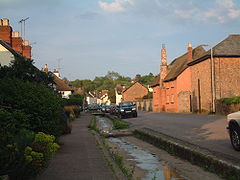
Otterton.
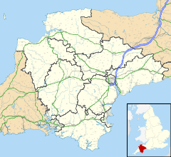
 Otterton shown within Devon
Population 700 (2001 census) OS grid reference SY080851 Shire county Devon Region South West Country England Sovereign state United Kingdom Postcode district EX9 Dialling code 01395 Police Devon and Cornwall Fire Devon and Somerset Ambulance South Western EU Parliament South West England UK Parliament East Devon List of places: UK • England • Devon Otterton is a village and civil parish in East Devon, England.
Contents
The village
The village is located on the east bank of the River Otter, east of the B3178 road and the village of East Budleigh. It is about a mile inland of Ladram Bay, on the Jurassic Coast. It was first settled by the Saxons and because of its favourable location and rich resources was by 1000 AD the centre of one of the major rural communities in Devon.[1]
The church, dedicated to St Michael, belonged to the monastery of Mont Saint-Michel at the time of the Domesday Book. After passing through ownership by Syon Abbey in the 15th century, it was bought by Richard Duke at the Dissolution.[2] Duke converted some of the monastic buildings into a mansion, part of which still exists to the north of the present-day church, which was rebuilt in 1869–71 by Benjamin Ferrey.[3] Burials in the churchyard ceased in 1986.[4]
The village includes attractive cob and thatched cottages and is the location of Otterton Mill which is a watermill and craft centre.
The Budleigh Salterton Railway, which was open from 1897 to 1967, ran along the valley of the River Otter. The station known as East Budleigh was closer to Otterton, being just over the river from the village. The platform and station building survive as a private house.[5]
The parish
Otterton civil parish is bounded by the coast on the east and the River Otter on the west; these two bounds meet at the mouth of the river, just east of the town of Budleigh Salterton, after passing through the 57-acre (230,000 m2) Otter Estuary Nature Reserve - a Site of Special Scientific Interest. The northern parish boundary leaves the river near Colaton Raleigh and swings south to meet the coast at Peak Hill, west of Sidmouth.[6]
About ¾ of a mile west along the coast from Peak Hill is High Peak, a 157-metre high cliff. Excavations into the earthworks on top of this have shown habitation in the Iron Age, Roman period and in the 6th–8th centuries AD. Many of these earthworks have been lost to the sea by erosion.[2] The cliffs below High Peak have yielded rare fossils from the Middle Triassic age, for example Mastodonsaurus.[7]
References
- ^ Millington, Gerald. "A History of the Otter Estuary, Ice-age to Saxon period. Budleigh Salterton, Otterton, East Budleigh.". Otter Valley Association. http://www.ovapedia.org.uk/index.php?page=a-history-of-the-otter-estuary-ice-age-to-saxon-period-budleigh-salterton-otterton-east-budleigh. Retrieved 2010-07-01.
- ^ a b Harris, Helen (2004). A Handbook of Devon Parishes. Tiverton: Halsgrove. p. 129. ISBN 1-84114-314-6.
- ^ Pevsner, Nikolaus; Cherry, Bridget (revision) (1989) [1952]. The Buildings of England: Devon. Harmondsworth: Penguin Books. pp. 614–615. ISBN 0 14 071050 7.
- ^ London Gazette: (Supplement) no. 50472. p. 4373. 27 March 1986. Retrieved 23 September 2011.
- ^ Catford, Nick. "East Budleigh Station". Disused Stations. http://www.disused-stations.org.uk/e/east_budleigh/index.shtml. Retrieved 2010-07-02.
- ^ Ordnance Survey 1:25,000 scale map. Sheet 115: Exmouth & Sidmouth (2004)
- ^ "Educational Register of Geological Sites: Ladram Bay to Sidmouth". Devon County Council. http://www.devon.gov.uk/geo-ladram-bay-to-sidmouth.pdf. Retrieved 2010-07-02.
External links
 Civil parishes in the ceremonial county of Devon
List of civil parishes in Devon Exeter1,2 NoneEast Devon1 All Saints • Awliscombe • Axminster • Axmouth • Aylesbeare • Beer • Bicton • Brampford Speke • Branscombe • Broad Clyst • Broadhembury • Buckerell • Budleigh Salterton • Chardstock • Clyst Honiton • Clyst Hydon • Clyst St George • Clyst St Lawrence • Clyst St Mary • Colaton Raleigh • Colyton • Combe Raleigh • Combpyne Rousdon • Cotleigh • Dalwood • Dunkeswell • East Budleigh • Exmouth • Farringdon • Farway • Feniton • Gittisham • Hawkchurch • Honiton • Huxham • Isle of Man • Kilmington • Luppitt • Lympstone • Membury • Monkton • Musbury • Nether Exe • Newton Poppleford and Harpford • Northleigh • Offwell • Otterton • Ottery St Mary • Payhembury • Plymtree • Poltimore • Rewe • Rockbeare • Seaton • Sheldon • Shute • Sidmouth • Southleigh • Sowton • Stockland • Stoke Canon • Talaton • Uplyme • Upottery • Upton Pyne • Whimple • Widworthy • Woodbury • YarcombeMid Devon1 Bampton • Bickleigh • Bow • Bradninch • Brushford • Burlescombe • Butterleigh • Cadbury • Cadeleigh • Chawleigh • Cheriton Bishop • Cheriton Fitzpaine • Clannaborough • Clayhanger • Clayhidon • Coldridge • Colebrooke • Copplestone • Crediton • Crediton Hamlets • Cruwys Morchard • Cullompton • Culmstock • Down St Mary • Eggesford • Halberton • Hemyock • Hittisleigh • Hockworthy • Holcombe Rogus • Huntsham • Kennerleigh • Kentisbeare • Lapford • Loxbeare • Morchard Bishop • Morebath • Newton St Cyres • Nymet Rowland • Oakford • Poughill • Puddington • Sampford Peverell • Sandford • Shobrooke • Silverton • Stockleigh English • Stockleigh Pomeroy • Stoodleigh • Templeton • Thelbridge • Thorverton • Tiverton • Uffculme • Uplowman • Upton Hellions • Washfield • Washford Pyne • Wembworthy • Willand • Woolfardisworthy • Zeal MonachorumNorth Devon1 Arlington • Ashford • Atherington • Barnstaple • Berrynarbor • Bishop's Nympton • Bishop's Tawton • Bittadon • Bratton Fleming • Braunton • Brayford • Brendon • Burrington • Challacombe • Chittlehamholt • Chittlehampton • Chulmleigh • Combe Martin • Countisbury • East and West Buckland • East Anstey • East Down • East Worlington • Filleigh • Fremington • Georgeham • George Nympton • Goodleigh • Heanton Punchardon • Horwood, Lovacott and Newton Tracey • Ilfracombe • Instow • Kentisbury • King's Nympton • Knowstone • Landkey • Loxhore • Lynton and Lynmouth • Mariansleigh • Martinhoe • Marwood • Meshaw • Molland • Mortehoe • North Molton • Parracombe • Pilton West • Queen's Nympton • Rackenford • Romansleigh • Rose Ash • Satterleigh and Warkleigh • Shirwell • South Molton • Stoke Rivers •Swimbridge • Tawstock • Trentishoe • Twitchen • West Anstey •West Down • Westleigh • Witheridge •Torridge1 Abbots Bickington • Abbotsham • Alverdiscott • Alwington • Ashreigney • Ashwater • Beaford • Bideford • Black Torrington • Bradford • Bradworthy • Bridgerule • Broadwoodwidger • Buckland Brewer • Buckland Filleigh • Bulkworthy • Clawton • Clovelly • Cookbury • Dolton • Dowland • East Putford • Frithelstock • Great Torrington • Halwill • Hartland • High Bickington • Hollacombe • Holsworthy • Holsworthy Hamlets • Huish • Huntshaw • Landcross • Langtree • Littleham • Little Torrington • Luffincott • Merton • Milton Damerel • Monkleigh • Newton St Petrock • Northam • Northcott • Pancrasweek • Parkham • Peters Marland • Petrockstow • Pyworthy • Roborough • Shebbear • Sheepwash • St Giles in the Wood • St Giles on the Heath • Sutcombe • Tetcott • Thornbury • Virginstow • Weare Giffard • Welcombe • West Putford • Winkleigh • Woolfardisworthy • Yarnscombe •West Devon1,3 Beaworthy • Belstone • Bere Ferrers • Bondleigh • Bradstone • Bratton Clovelly • Brentor • Bridestowe • Bridestowe and Sourton Common • Broadwoodkelly • Buckland Monachorum • Chagford • Coryton • Dartmoor Forest • Drewsteignton • Dunterton • Exbourne • Germansweek • Gidleigh • Gulworthy • Hatherleigh • Highampton • Horrabridge • Iddesleigh • Inwardleigh • Jacobstowe • Kelly • Lamerton • Lewtrenchard • Lifton • Lydford • Marystow • Mary Tavy • Meavy • Meeth • Milton Abbot • Monkokehampton • North Tawton • Northlew • Okehampton • Okehampton Hamlets • Peter Tavy • Sampford Courtenay • Sampford Spiney • Sheepstor • Sourton • South Tawton • Spreyton • Sticklepath • Stowford • Sydenham Damerel • Tavistock • Throwleigh • Thrushelton • Walkhampton • Whitchurch •South Hams1 Ashprington • Aveton Gifford • Berry Pomeroy • Bickleigh • Bigbury • Blackawton • Brixton • Buckland Tout Saints • Charleton • Chivelstone • Churchstow • Cornwood • Cornworthy • Dartington • Dartmouth • Dean Prior • Diptford • Dittisham • East Allington • East Portlemouth • Ermington • Frogmore and Sherford • Halwell and Moreleigh • Harberton • Harford • Holbeton • Holne • Ivybridge • Kingsbridge • Kingston • Kingswear • Littlehempston • Loddiswell • Malborough • Marldon • Modbury • Newton and Noss • North Huish • Rattery • Ringmore • Salcombe • Shaugh Prior • Slapton • South Brent • South Huish • South Milton • South Pool • Sparkwell • Staverton • Stoke Fleming • Stoke Gabriel • Stokenham • Strete • Thurlestone • Totnes Ugborough • Wembury • West Alvington • West Buckfastleigh • Woodleigh • YealmptonTeignbridge1 Abbotskerswell • Ashburton • Ashcombe • Ashton • Bickington • Bishopsteignton • Bovey Tracey • Bridford • Broadhempston • Buckfastleigh • Buckland-in-the-Moor • Christow • Chudleigh • Coffinswell • Dawlish • Denbury and Torbryan • Doddiscombsleigh • Dunchideock • Dunsford • Exminster • Haccombe with Combe • Hennock • Holcombe Burnell • Ide • Ideford • Ilsington • Ipplepen • Kenn • Kenton • Kingskerswell • Kingsteignton • Lustleigh • Mamhead • Manaton • Moretonhampstead • Newton Abbot • North Bovey • Ogwell • Powderham • Shaldon • Shillingford St George • Starcross • Stokeinteignhead • Tedburn St Mary • Teigngrace • Teignmouth • Trusham • Whitestone • Widecombe-in-the-Moor • WoodlandPlymouth2,4 NoneTorbay4 Bold text denotes a parish council refered to as a "town council".
- Non-metropolitan district of the non-metropolitan county of Devon (administered by Devon County Council).
- Has city status in the United Kingdom.
- Has borough status in the United Kingdom.
- Unitary authority not part of the non-metropolitan county, thus not administered by Devon County Council.
- The remainder of Torbay is unparished.
Categories:- Civil parishes in Devon
- Villages in Devon
Wikimedia Foundation. 2010.

