- Diptford
-
Coordinates: 50°23′40″N 3°47′42″W / 50.394516°N 3.795137°W
Diptford 
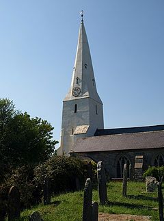
St Mary's church, Diptford
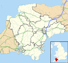
 Diptford shown within Devon
OS grid reference SX7256 Parish Diptford District South Hams Shire county Devon Region South West Country England Sovereign state United Kingdom Police Devon and Cornwall Fire Devon and Somerset Ambulance South Western EU Parliament South West England List of places: UK • England • Devon Diptford is a village in the county of Devon, England. It is perched on a hill overlooking the River Avon. The name is believed to come from "deep ford", referring to the local site of a river crossing.
At the centre of the village is a small primary school,[1] the parish hall and the recently redeveloped 14th century church. There is also a temporary pub, which is open 4 times a year.
References
External links
Non-metropolitan district of South Hams List of civil parishes in Devon#South Hams Civil parishes Ashprington • Aveton Gifford • Berry Pomeroy • Bickleigh • Bigbury • Blackawton • Brixton • Buckland Tout Saints • Charleton • Chivelstone • Churchstow • Cornwood • Cornworthy • Dartington • Dartmouth • Dean Prior • Diptford • Dittisham • East Allington • East Portlemouth • Ermington • Frogmore and Sherford • Halwell and Moreleigh • Harberton • Harford • Holbeton • Holne • Ivybridge • Kingsbridge • Kingston • Kingswear • Littlehempston • Loddiswell • Malborough • Marldon • Modbury • Newton and Noss • North Huish • Rattery • Ringmore • Salcombe • Shaugh Prior • Slapton • South Brent • South Huish • South Milton • South Pool • Sparkwell • Staverton • Stoke Fleming • Stoke Gabriel • Stokenham • Strete • Thurlestone • Totnes Ugborough • Wembury • West Alvington • West Buckfastleigh • Woodleigh • YealmptonBold text denotes a parish council refered to as a "town council" i.e. towns. Categories:- Devon geography stubs
- Civil parishes in South Hams
- Villages in South Hams
Wikimedia Foundation. 2010.

