- Modbury
-
Coordinates: 50°20′57″N 3°53′13″W / 50.349111°N 3.886896°W
Modbury 
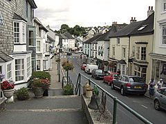
View down Church Street, Modbury
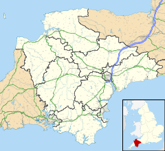
 Modbury shown within Devon
Population 1,454 (2001)[1] OS grid reference SX63835946 - London 181 mi (291 km) Parish Harford District South Hams Shire county Devon Region South West Country England Sovereign state United Kingdom Post town IVYBRIDGE Postcode district PL21 Dialling code 01548 Police Devon and Cornwall Fire Devon and Somerset Ambulance South Western EU Parliament South West England UK Parliament South West Devon Website Modbury Parish Council website List of places: UK • England • Devon Modbury is a town and parish in the South Hams region of the English county of Devon. It is situated on the A379 road, which links it to Plymouth and Kingsbridge. The current parish population is approximately 1,500.
Contents
Etymology
The name Modbury is a corruption of the Anglo-Saxon name, Moot burgh from 'Moot' meaning either 'Mud' or 'Meeting' and 'Bury' meaning 'Fortified Enclosure'.
History
Modbury is recorded in the Domesday Book.
The population of the town was greatly reduced as a consequence of the Black Death.
Katherine 'Kat' Ashley née Champernowne (? - 1565) governess to Elizabeth I was probably born in or near the village.
John Batterson Stetson, founder of the Stetson cowboy hat company in the U.S., is descended from Modbury natives Robert Stetson and Honour Tucker (who emigrated to Massachusetts c. 1634).[2]
Civil War
It was the site of two battles in the English Civil War. The first battle was a minor royalist victory on December 9, 1642, when a small Royalist force put to flight a smaller Parliamentarian force.
The second Battle of Modbury occurred on February 21, 1643 when the Royalists forces, expecting an attack by Parliamentarian forces assembled at nearby Kingsbridge, had fortified the town. Outnumbered approximately four to one, and running short of ammunition, the royalists retreated. This victory was largely instrumental in the lifting of the Siege of Plymouth, and the driving of the encircling Royalist forces into Cornwall.
19th century
By 1801, the population of Modbury had risen to 1,813, with almost half engaged in the wool trade. The impact of the mechanisation of the wool industry was to have a dramatic effect on the economic prosperity and population of the town in the mid 1820s and later. Many workers left the town and headed to large cities in search of employment; others left the country altogether, emigrating to America.
The railway line bypassed Modbury, contributing still further to this decline. Modbury remained an important market town until as late as 1944 when the cattle market ceased.
Plastic bag ban
In April 2007 local traders declared that for environmental reasons, they would no longer give customers plastic bags.[3][4][5] This initiative led to other communities, such as Ilam in Staffordshire and Hebden Bridge in West Yorkshire, to pursue similar enterprises.[6]
Modbury Rovers FC
Modbury has a recreation field with a football pitch, tennis courts, and a tarmac all-weather surface used mainly for skateboarding. This is the home of Modbury Rovers, who are managed by Alex Pitcher and compete in the Plymouth and West Devon Combination League.
References
- ^ "Parish Headcounts". The Office for National Statistics. 2001-04-01. http://neighbourhood.statistics.gov.uk/dissemination/LeadTableView.do?a=7&b=793715&c=Modbury&d=16&e=15&g=437110&i=1001x1003x1004&m=0&r=1&s=1288126320179&enc=1&dsFamilyId=779. Retrieved 2010-10-26.
- ^ Stetson Kindred/History
- ^ Vidal, John (28 April 2007). "Welcome to Modbury. Just don't ask for a plastic bag". The Guardian. http://www.guardian.co.uk/environment/2007/apr/28/plasticbags.frontpagenews. Retrieved 2011-08-15.
- ^ Elliott, Valerie (28 April 2007). "Modbury (pop 1,553) is first to ban plastic bags". The Times. http://www.timesonline.co.uk/tol/news/uk/article1717476.ece. Retrieved 2011-08-15.
- ^ Barkham, Patrick (12 May 2007). "World asks town that banned the plastic bag: how can we do it too?". The Guardian. http://www.guardian.co.uk/environment/2007/may/12/uknews.waste. Retrieved 2011-08-15.
- ^ Sunday Telegraph 22nd July 2007 2, 406 pC12
External links
Non-metropolitan district of South Hams List of civil parishes in Devon#South Hams Civil parishes Ashprington • Aveton Gifford • Berry Pomeroy • Bickleigh • Bigbury • Blackawton • Brixton • Buckland Tout Saints • Charleton • Chivelstone • Churchstow • Cornwood • Cornworthy • Dartington • Dartmouth • Dean Prior • Diptford • Dittisham • East Allington • East Portlemouth • Ermington • Frogmore and Sherford • Halwell and Moreleigh • Harberton • Harford • Holbeton • Holne • Ivybridge • Kingsbridge • Kingston • Kingswear • Littlehempston • Loddiswell • Malborough • Marldon • Modbury • Newton and Noss • North Huish • Rattery • Ringmore • Salcombe • Shaugh Prior • Slapton • South Brent • South Huish • South Milton • South Pool • Sparkwell • Staverton • Stoke Fleming • Stoke Gabriel • Stokenham • Strete • Thurlestone • Totnes Ugborough • Wembury • West Alvington • West Buckfastleigh • Woodleigh • YealmptonBold text denotes a parish council refered to as a "town council" i.e. towns. Categories:- Civil parishes in South Hams
- Towns in Devon
Wikimedia Foundation. 2010.

