- South Molton
-
"Molton" redirects here. Or see Molten or Moulton.
Coordinates: 51°01′N 3°50′W / 51.02°N 3.83°W
South Molton
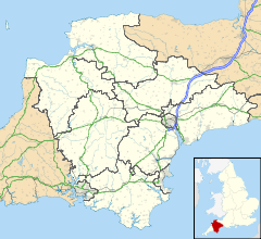
 South Molton shown within Devon
Population 4,093 (2001 Census) District North Devon Shire county Devon Region South West Country England Sovereign state United Kingdom Post town SOUTH MOLTON Postcode district EX36 Dialling code 01769 Police Devon and Cornwall Fire Devon and Somerset Ambulance South Western EU Parliament South West England UK Parliament North Devon List of places: UK • England • Devon South Molton is a small town in Devon, England. It is part of the North Devon local government district. The town is on the River Mole. According to the 2001 census the civil parish of South Molton had a population of 4,093.
The town was one of the boroughs reformed by the Municipal Reform Act 1835. It retained this status as a municipal borough until 1967, when it became a rural borough in the South Molton Rural District.[1]
On 14 March 1655 Sir John Penruddock was captured after a three-hour street fight in South Molton by soldiers of the New Model Army under the command of Captain Unton Crook. With his capture the Penruddock uprising came to an end and so did the 1655 plans of the Sealed Knot to restore King Charles II to the throne of England.
It is a small, well built market town trading mostly in sheep and cattle. Situated on the southern side of Exmoor just off the North Devon link road.
Contents
Education
There are good local educational facilities, South Molton College[2] which is a state secondary school rated as a specialist technology college.
South Molton Primary School was one of the schools studied in the 1950s by Iona and Peter Opie.[3]
See also
- South Molton (UK Parliament constituency) (1885–1950)
References
- ^ Vision of Britain
- ^ South Molton Community College website
- ^ Opie, Iona & Peter (1959) The Lore and Language of Schoolchildren Oxford: Clarendon Press
External links
Categories:- Towns in Devon
Wikimedia Foundation. 2010.

