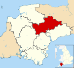
- Mid Devon
-
Coordinates: 50°54′00″N 3°29′24″W / 50.900°N 3.490°W
Mid Devon District — Non-metropolitan district — Mid Devon shown within Devon Sovereign state United Kingdom Constituent country England Region South West England Non-metropolitan county Devon Status Non-metropolitan district Admin HQ Tiverton Incorporated 1 April 1974 Government - Type Non-metropolitan district council - Body Mid Devon District Council - Leadership Alternative - Sec.31 (Conservative) - MPs Neil Parish
Mel StrideArea - Total 222.8 sq mi (577.1 km2) Area rank 33rd (of 326) Population (2010 est.) - Total 76,100 - Rank 292nd (of 326) - Density 341.5/sq mi (131.9/km2) - Ethnicity 99.2% White Time zone GMT (UTC0) - Summer (DST) BST (UTC+1) ONS code 18UD OS grid reference SS9523512287 Website middevon.gov.uk Mid Devon is a local government district in Devon, England. Its council is based in Tiverton.
The district was formed under the Local Government Act 1972, on 1 April 1974 by the merger of the borough of Tiverton and Crediton urban district together with Tiverton Rural District, and Crediton Rural District[1]. It was originally called Tiverton District, but was renamed in 1978 by resolution of the district council.[2] The main Town in Mid Devon is Tiverton, it is a major, busy town set in the heart of Devon.
Contents
Geography
Mid Devon shares borders with several other Devon districts as well as the county of Somerset. Neighbouring districts include Exeter, East Devon, North Devon, Teignbridge, West Devon and Torridge.
Rivers running through Mid Devon
Several rivers run through the district of Mid Devon, including the Exe, the Culm and the Yeo.
Raddon Top
Raddon Top (772 ft.) is a landmark for 20 miles around. Westcote tells us that there was an earthwork on the summit, practically ploughed down even in his day. The views from here are superb, even for Devon.[3]
Tourism
Grand Western Canal
The Grand Western Canal stretches from Canal Hill in Tiverton to just outside Greenham in Somerset. It no longer operates for trade purposes, but is a popular tourist location. Visitors are able to walk along its banks or take a trip down the canal in a horse drawn barge. A static barge also operates at the Canal Hill end of the canal, offering refreshments. The site is one of two tourism spots owned by Devon County Council.
Exmoor
Exmoor National Park is a national park situated in Mid Devon and Somerset in South West England. The park covers 267 square miles (692 km²) of hilly open moorland. Exmoor is one of the first British National Parks, designated in 1954, and is named after its main river, the River Exe. Several areas of the moor have been declared a Site of Special Scientific Interest.
Devon Railway Centre
The Devon Railway Centre is located at Bickleigh in Mid Devon, on a station site on the closed Great Western Railway branch from Exeter to Dulverton. The Railway operates a 2 ft (610mm) gauge passenger railway and has the largest narrow gauge collection in the South West. An attractive miniature railway is also located at the site. There is also a collection of model railways at the Centre where some of the nation's most famous working layouts can be seen. The original Victorian station has been restored.
Major settlements
Several towns and large villages exist in Mid Devon. The major town is Tiverton, but other towns include Cullompton and Crediton.
References
- ^ The English Non-metropolitan Districts (Definition) Order 1972 (SI 1972/2039)
- ^ London Gazette: no. 47488. p. 3251. 14 March 1978.
- ^ Devon Libraries Local Studies Shobroke Community Page, 22 February 2005
 Districts of South West England
Devon Dorset Gloucestershire Somerset Unitary authorities Bath and North East Somerset · Bournemouth · Bristol · Cornwall · Isles of Scilly · North Somerset · Plymouth · Poole · South Gloucestershire · Swindon · Torbay · WiltshireCategories:- Local government in Devon
- Non-metropolitan districts of Devon
- Local government districts of South West England
- Mid Devon
Wikimedia Foundation. 2010.

