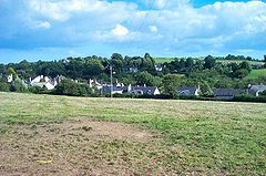
Broadhempston

Broadhempston
Broadhempston
Broadhempston - geograph.org.uk - 40487.jpg
Broadhempston
Population 641 (2001)
OS grid reference SX8066
Parish Broadhempston
District Teignbridge
Shire county Devon
Region South West
Country England
Sovereign state United Kingdom
Post town TOTNES
Postcode district TQ9
Dialling code 01803
Police Devon and Cornwall
Fire Devon and Somerset
Ambulance South Western
EU Parliament South West England
UK Parliament Newton Abbot
List of places: UK • England • Devon

Broadhempston is a small village within the Teignbridge District Council Area in the County of Devon in the South West of England ("The West Country"). It comprises 257 houses with a population (total parish) of 641.[1]

It has a good mix of generations with a church, a primary school, two pubs (the Monk's Retreat and the Coppa Dolla) and a shop/post office. The working population tends to work in neighbouring cities and towns such as Torquay, Exeter and Plymouth. There is a higher than average proportion of professional and managerial staff than the national and house ownership, as a measure of prosperity, is also high. Many of the villagers are "incomers" and they now outnumber "natives".

Until the last few years, there were five working farms within the village itself, but, in common with many rural areas, the decline in farming has meant that these are now no longer in business and have become part of the housing pool of the village.

The village is very old, having been founded in Saxon times, although the church itself is more modern, having been built in the 13th century. It suffers from diminishing congregations, although remains a focus for many village activities. The vicar serves four parishes as well as Broadhempston.

The 15th-century almshouse is now an inn. The church has a 13th-century Chancel, and 15th-century arcades, beams and bosses. The fine screen is equally old, but the baptismal font is over 600 years old. Giles Hussey, artist and theorist, is buried in the churchyard.[2]

There is a Community Woodland Project being developed. This currently has public access for pedestrians. They are in the process of developing plans to build the woodland as a community educational resource.

References

  1. ^ Office for National Statistics : Census 2001 : Parish Headcounts : Teignbridge Retrieved 25 June 2010
  2. ^ Dictionary of National Biography

External links

Media related to Broadhempston at Wikimedia Commons

Coordinates: 50°29′N 3°41′W / 50.483°N 3.683°W / 50.483; -3.683


Wikimedia Foundation. 2010.

Игры ⚽ Нужно сделать НИР?

Look at other dictionaries:

  • South Devon Football League — The South Devon League is a football competition based in England, and is sponsored by WBW Solicitors. Its top division, the Premier Division , sits at level 8 of the English football league system. This league is a feeder to the South West… …   Wikipedia

  • South Hams — is a local government district on the south coast of Devon, England. It contains the towns of Dartmouth, Kingsbridge, Ivybridge, Salcombe, and Totnes, where the district council has its offices.To the north it includes part of Dartmoor National… …   Wikipedia

  • Teignbridge — is a local government district in Devon, England. Its council is based in Newton Abbot.Other towns in the district include Ashburton, Dawlish and Teignmouth. It is named for the old Teignbridge hundred.The district was formed on April 1, 1974,… …   Wikipedia

  • List of places in Devon — This is a list of settlements and places of interest in Devon, England. See List of places in England for settlements in other counties. NOTOC A*Abbots Bickington *Abbotsham *Abbotskerswell *Alverdiscott *Appledore (Mid Devon) *Appledore (North… …   Wikipedia

  • List of civil parishes in Devon — Blank map of civil parish boundaries in Devon This is a list of civil parishes in the ceremonial county of Devon, England. Contents 1 Ea …   Wikipedia

  • Ipplepen — is a small village located within the county of Devon in south west England. It has approximately 2000 residents and it is situated about 4 miles to the west of the market town of Newton Abbot. Ipplepen is also located just 6 miles from the… …   Wikipedia

  • Otterton — Coordinates: 50°39′29″N 3°18′04″W / 50.658178°N 3.301008°W / 50.658178; 3.301008 …   Wikipedia

  • List of Grade I listed buildings in Devon — There are over 6000 Grade I listed buildings in England. This page is a list of these buildings in the county of Devon, sub divided by district.East Devon* Church of St Michael All Angels, Awliscombe * Weycroft Hall, Axminster * Church of St… …   Wikipedia

  • Charles Mole — Sir Charles Johns Mole KBE, MVO (1886–1962) was a British architect who served in the Ministry of Works, eventually becoming its Director General.[1] Career Mole was born in 1886 in Broadhempston in the English county of Devon. He was initially… …   Wikipedia

  • Dean Prior — St George Martyr, Dean Prior Dean Prior is a village and civil parish near the A38 road, in the South Hams district, in the county of Devon, England. It is located near the town of Buckfastleigh. Dean Prior has a church called St George Martyr,… …   Wikipedia

Share the article and excerpts

Direct link
Do a right-click on the link above
and select “Copy Link”